 BharatNotes
Part 6 of 6 of the Astronomical Geography notes. The overview page has the quick revision, exam strategy and key terms for all six parts.
Maps and Projections
A globe shows the curved surface of the Earth, but it is awkward to use and its scale is necessarily small. A flat map is handier, but it has to stretch, squeeze or cut that surface, and the rule it follows to do so is a map projection. This section explains what a projection can and cannot keep true, the three families of projection, why Mercator's map makes Greenland look enormous, and why the shortest route between two places looks curved on most maps.
Why every flat map distorts
Peel an orange and try to press the peel flat: it splits or stretches. The Earth's surface behaves the same way, so no flat map can show it without distortion. The US Geological Survey's working manual on projections (Snyder, 1987) puts it plainly: "Since this cannot be done without distortion, the cartographer must choose the characteristic which is to be shown accurately at the expense of others, or a compromise of several characteristics." The properties a projection can keep are these:
What a projection can keep true
| Property | What stays true | The catch |
|---|---|---|
| Conformal | Angles, and so the shapes of small areas; meridians cross parallels at right angles, as on the globe | Areas are generally enlarged or reduced |
| Equal-area | The relative size of every area | Shapes, angles and scale are distorted on most parts of the map |
| Equidistant | True scale from one or two points to every other point, or along every meridian | No projection shows scale correctly throughout the map; it is true only from the chosen points or along the chosen lines |
| Azimuthal | Directions from the centre to every other point | Combines with the others: one azimuthal projection is also equal-area, another conformal, another equidistant |
Snyder, J. P. (1987), Map Projections: A Working Manual, US Geological Survey Professional Paper 1395, chapter 1, "Characteristics of map projections".
Key idea
Snyder states the central rule in one line: "No map can be both equal-area and conformal." Every flat map of the world trades true shape against true size, and the choice depends on what the map is for.
Cylinder, cone and plane
Many projections can be pictured as wrapping a sheet round the globe, transferring the grid of latitude and longitude onto it, and then laying the sheet flat. The sheet must be a developable surface, which Snyder defines as "one that can be transformed to a plane without distortion". Of the three he names, "They are the cylinder, the cone, and the plane."
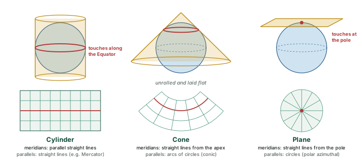
On a cylinder touching the Equator, Snyder explains, the meridians become "equidistant straight lines perpendicular to the Equator". On a cone, once it is cut and laid flat, "the meridians remain straight radiating lines, but the parallels are now circular arcs centered on the apex", and the angles between meridians come out smaller than the true angles. On a plane touching a pole the meridians radiate from the pole at their true angles, and "The parallels of latitude are complete circles, centered on the pole." The spacing of the parallels is then chosen to give the property the map needs.
The Mercator projection
The best-known cylindrical projection is Mercator's, which Snyder records as "Presented by Mercator in 1569". It is conformal. Its meridians are equally spaced straight lines, and its parallels are straight lines that are "closest near the Equator" and spread further apart towards the poles. The reason is arithmetic. Every parallel is drawn as long as the Equator, although on the globe the parallel at latitude φ is only cos φ times as long, so the map stretches east-west by 1 ÷ cos φ (computed). To keep shapes true it must stretch north-south by the same factor: twice at 60°, and without limit towards the poles, which Snyder notes "are at infinity".
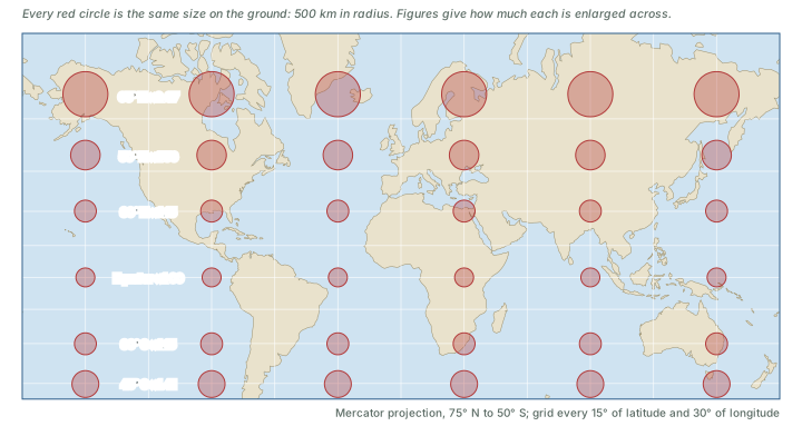
Mercator's map has one great practical strength. A rhumb line (or loxodrome), a line that keeps one compass bearing, appears on it as a straight line: "Loxodromes (rhumb lines) are straight lines." A navigator can draw a straight line between two ports, read its bearing off the chart and hold that course. Snyder's summary of its use is three words long: "Used for navigation."
How much Mercator enlarges
The price of true shapes and straight rhumb lines is area. Snyder gives the textbook case: "The classic comparison of areas is between Greenland and South America. Greenland appears larger, although it is only one-eighth the size of South America." The diagram below and the table below measure the effect directly from the map outlines.
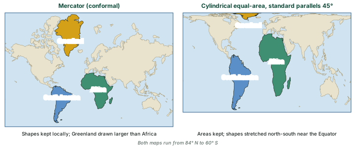
Area on the globe and on a Mercator map (computed)
| Landmass | True area (million km²) | Area on a Mercator map at Equator scale (million km²) | Enlarged by |
|---|---|---|---|
| Greenland | 2.19 | 36.2 | × 16.5 |
| South America | 17.8 | 20.8 | × 1.2 |
| Africa (with Madagascar) | 30.0 | 33.5 | × 1.1 |
Computed from the Natural Earth 1:110m countries (public domain; used only to pick out the three landmasses, no borders drawn) outlines, densified to 0.25°, on a sphere of radius 6,371 km: true area with the Lambert cylindrical equal-area formula, map area with the Mercator formula. The 1:110m outlines are generalised, so the areas are approximate.
On the globe, Africa is about 14 times the size of Greenland and South America about 8 times (computed from the table above). On a Mercator map the order is reversed: Greenland covers more paper than Africa, and about 1.7 times as much as South America, because it lies between about 60° N and 84° N, where the stretch is greatest.
Don't confuse
Conformal (Mercator) keeps angles and the shapes of small areas but not sizes. Equal-area (Gall-Peters) keeps sizes but not shapes. No map does both. In a question, "true shape" or "constant bearing" points to Mercator; "true relative size" points to an equal-area map.
Great circles and rhumb lines
The shortest route between two places on a sphere runs along a great circle (see the section on Latitude and Longitude). A rhumb line keeps one compass bearing instead, and Snyder states the consequence: a rhumb line "is usually longer than the great circle path (which is the shortest possible route on the sphere). It is the same length as a great circle only if it follows the Equator or a meridian." Which of the two looks straight depends on the projection: "On the Mercator projection, all rhumb lines, or lines of constant direction, are shown as straight lines", while on the gnomonic "all great circle paths" are.
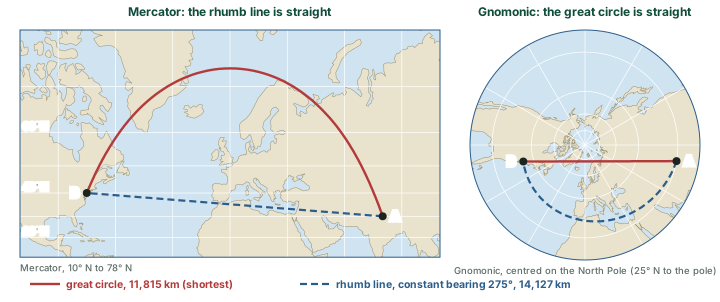
Worked example: great circle against rhumb line
Compare the great-circle route and the constant-bearing route from A (30° N, 80° E) to B (40° N, 75° W).
- Great circle: cos d = sin φA sin φB + cos φA cos φB cos Δλ, with Δλ = 155°, gives d = 11,815 km. The route leaves A on a bearing of 340° (north-north-west) and reaches about 73° N.
- Rhumb line: the constant bearing is 275°, almost due west, and the route is 14,127 km long.
- Difference: 14,127 − 11,815 = 2,312 km.
Answer: The rhumb line is about 20% longer. The great circle is shorter, but its bearing changes all the way along.
Remember
Straight on Mercator means constant bearing (a rhumb line). Straight on a gnomonic map means shortest route (a great circle). Only along the Equator or a meridian are the two the same line.
Azimuthal maps and the UN emblem
A plane touching the globe at one point gives an azimuthal projection, on which, in Snyder's words, "the directions or azimuths of all points on the map are shown correctly with respect to the center". The azimuthal equidistant projection also keeps distances from the centre true: "Distances measured from the center are true." Snyder lists its uses: "Used in the polar aspect for world maps and maps of polar hemispheres", and, centred elsewhere, for "world maps for aviation and radio use".
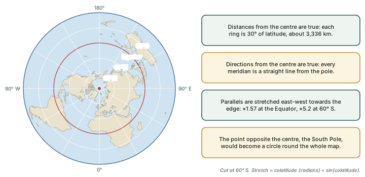
The gnomonic projection is azimuthal too, made by projecting the globe from its centre onto a touching plane. Its "outstanding (and only useful) feature", Snyder writes, is that every great-circle arc comes out as a straight line. It cannot show even a hemisphere ("Less than one hemisphere may be shown around a given center"), and away from the centre "the distortion of shape, area, and scale on the Gnomonic projection is so great that it has seldom been used for atlas maps".
The Equal Earth projection
Sections 9.3 and 9.4 showed the trade-off at its sharpest: Mercator keeps shapes but not sizes, and the Gall-Peters map keeps sizes but squashes shapes. Equal Earth is a recent attempt at a world map that keeps every area exactly true and still looks like the familiar globe. It was designed by three cartographers, Bojan Šavrič, Tom Patterson and Bernhard Jenny, and published in the International Journal of Geographical Information Science (online on 7 August 2018; volume 33, 2019). Their follow-up abstract for the International Cartographic Association calls it "a new pseudocylindrical projection for world maps. It is similar to the popular Robinson projection, but unlike the Robinson, it is an equal-area projection." It also gives the reason it was made: "The creation of this projection was motivated by a wave of news stories about Boston Public Schools switching to maps using the Peters projection." The abstract adds that the projection "shows continental outlines in a visually pleasing and balanced way".
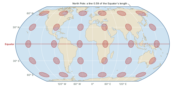
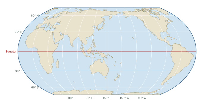
Pseudocylindrical means "false cylindrical". Snyder explains the name: such projections are "so called because latitude lines are straight and parallel, and meridians are equally spaced, as on cylindrical projections, but all meridians except the central meridian are curved instead of straight." Esri's description of Equal Earth matches: "All parallels, the central meridian, and both poles are presented as straight lines. The parallels are unequally spaced. The meridians are equally spaced and other than the central meridian are curved outward." Because the meridians bend inwards towards the poles, the poles are not stretched to the full width of the map as on a cylindrical projection: "The poles are 0.59247 times the length of the equator." This rounded outline is what makes the map look like a globe laid flat.
How it is built. The ICA abstract notes that "Its equations are simple to implement and fast to evaluate." The diagram below sets out the steps. First an auxiliary angle θ replaces the latitude φ, through sin θ = (√3/2) sin φ. The height of each parallel above the Equator is then a short polynomial in θ, and the distance along a parallel is the longitude scaled by cos θ and divided by the slope of that polynomial. The four constants are A₁ = 1.340264, A₂ = −0.081106, A₃ = 0.000893 and A₄ = 0.003796, as coded in the PROJ library.
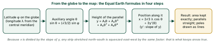
Do the numbers: Why the area comes out true (derived)
Take a small patch of the globe between latitudes φ and φ + dφ and longitudes λ and λ + dλ. On a globe of radius 1 its area is cos φ dφ dλ. On the map the patch becomes a thin parallelogram (slanted where the meridians curve, which changes its shape but not its area). Its height is dy = y′(θ) dθ and its width is (2√3 cos θ ÷ 3y′(θ)) dλ, so its area is (2√3 ÷ 3) cos θ dθ dλ: the slope y′ cancels. Differentiating sin θ = (√3/2) sin φ gives cos θ dθ = (√3/2) cos φ dφ. The map area is therefore (2√3 ÷ 3) × (√3 ÷ 2) × cos φ dφ dλ = cos φ dφ dλ, exactly the area on the globe. Because y′ cancels, the polynomial can be tuned for a pleasing shape without losing equal area.
What it keeps and what it bends. The whole map is 2.05 times as wide as it is tall, and each pole is a line 0.592 times the length of the Equator (computed; Esri gives 0.59247). Areas are exact everywhere, so Greenland, Africa and South America appear in their true proportions, unlike the Mercator areas in the table above. Shapes are not exact. Along the Equator the map stretches north-south by a factor of 1.161 and shrinks east-west to 0.862; on the central meridian at 60° the factors are 0.770 and 1.298 (computed). In each pair the two numbers multiply to 1, which is the equal-area property. Esri summarises the pattern: "Shapes, directions, angles, and distances are distorted and stretched north-south in tropical and mid-latitude areas. Nearer the poles, features are compressed in the north-south direction."
Shape distortion can be measured. Snyder calls it the maximum angular deformation, ω: "The greatest deviation from the correct angle is called ω, the maximum angular deformation. For a conformal map, ω is zero." It is computed from the two scale factors h and k at a point, through sin(ω/2) = |h − k| ÷ (h + k). The table below and the diagram below compare Equal Earth with the Gall-Peters type of equal-area map.
Shape distortion ω on two equal-area maps (computed)
| Latitude (N or S) | Gall-Peters type (standard parallels 45°) | Equal Earth, central meridian | Equal Earth, 90° from it | Equal Earth, map edge (180°) |
|---|---|---|---|---|
| 0° | 39° | 17° | 17° | 17° |
| 15° | 35° | 15° | 18° | 24° |
| 30° | 23° | 8° | 20° | 37° |
| 45° | 0° | 5° | 27° | 51° |
| 60° | 39° | 30° | 43° | 65° |
| 75° | 100° | 80° | 82° | 88° |
Computed from the scale factors of each projection on a sphere, with sin(ω/2) = |h − k| ÷ (h + k) (Snyder, J. P. (1987), Map Projections: A Working Manual, US Geological Survey Professional Paper 1395, equation 4-9). Equal Earth formulas: PROJ, eqearth.cpp (the Equal Earth code of the open-source PROJ library). On the Gall-Peters type ω does not change with longitude.
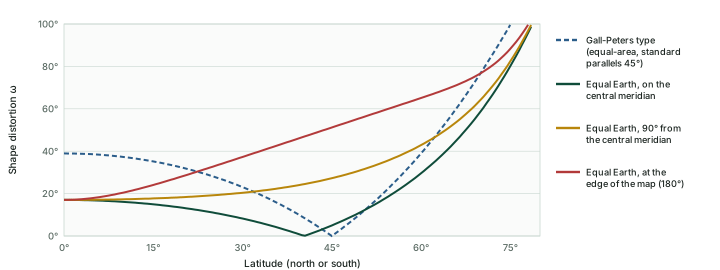
Between the Equator and 45°, Equal Earth's ω on the central meridian is at most 17°, while the Gall-Peters type reaches 39° at the Equator. Equal Earth's worst shapes lie in the high-latitude corners of the map, far from the central meridian. No world map escapes Snyder's rule from section 9.1; Equal Earth chooses where the unavoidable distortion goes.
Three centrings. A world map can be centred on any meridian. epsg.io records EPSG:8857, EPSG:8858 and EPSG:8859, all on the WGS 84 datum: "Equal Earth Greenwich" (central meridian 0°), "Equal Earth Americas" (90° W) and "Equal Earth Asia-Pacific" (150° E). The Asia-Pacific version moves the cut to 30° W, in the Atlantic, so the Pacific appears unbroken.
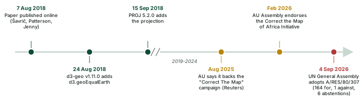
From a paper to the software. The projection spread quickly through mapping software. The d3-geo library for web maps added d3.geoEqualEarth in version 1.11.0 on 24 August 2018, and the open-source PROJ library added it in version 5.2.0 on 15 September 2018. Esri records that it "was quickly adopted by the NASA Goddard Institute for Space Studies (GISS)" and is "available in ArcGIS Pro 2.3 and later and in ArcGIS Desktop 10.7 and later". The GISS page of global temperature animations states: "These animations use the equal-area Equal Earth map projection." Esri's guidance on use is that it suits "thematic world maps illustrating area characteristics and analysis requiring accurate areas".
Endorsement by the African Union and a UN resolution. In August 2025 Reuters reported that "The African Union has backed a campaign to end the use by governments and international organisations of the 16th-century Mercator map", a campaign called "Correct The Map" that promotes Equal Earth. In February 2026 the 39th Ordinary Session of the AU Assembly "endorsed the Correct the Map of Africa Initiative, championed by Togo", according to the AU's press release. On 4 September 2026 the UN General Assembly adopted resolution 80/307, titled "'Correct the map': rebalancing global cartographic representation and promoting equitable representation of the world's regions, particularly Africa", by "a recorded vote of 164 in favour to 1 against (United States), with 6 abstentions (Estonia, Georgia, Lithuania, Republic of Moldova, Serbia, Ukraine)".
What resolution 80/307 says. It "Declares that the Equal Earth cartographic projection offers a more accurate representation of the sizes of continental landmasses" and "Encourages Member States, international organizations and other relevant entities to adopt, disseminate and use the Equal Earth cartographic projection and equal area map projection methods". Its preamble notes that the Mercator projection, "designed in the sixteenth century for navigational purposes, remains widely used in educational, media, digital and official materials", and notes "with concern that this distortion contributes to minimizing the perceived sizes of Africa, Latin America and South Asia". It encourages "the critical teaching of cartography" in school curricula, and it is "without prejudice to the established practice with regard to the use of cartographic material for navigational purposes".
What it does not do. UN News: "The resolution does not ban the Mercator projection or impose a replacement." It describes the measure as "nonbinding". On the AU's step, the two bodies use different words: the AU says its Assembly "endorsed" the Correct the Map initiative, while the UN resolution notes "with satisfaction the adoption by the African Union of the Equal Earth cartographic projection".
Sources: UN General Assembly resolution A/RES/80/307 (adopted 4 September 2026); UN Press, GA/12779 (4 September 2026); UN News (4 September 2026); African Union, Press Release No. 0118/2026 (12 June 2026).
India's position. India voted in favour. Explaining the vote, Raghoo Puri, First Secretary at India's Permanent Mission to the UN, said India "welcomes" the intention behind the resolution, and added: "We believe that the resolution should be understood as supporting the broader use and consideration of Equal Area map projections, and not as endorsing the Equal Earth projection or any other specific map projection." Two days later the Ministry of External Affairs spokesperson, Randhir Jaiswal, was reported as saying that "The resolution neither adopts nor authenticates any particular world map, nor does it address political cartography, including international boundaries, disputed territories or place names." The same statement added: "India's sovereign territory, including the Union Territories of Jammu and Kashmir and Ladakh, must be depicted in accordance with India's official map." No move to Equal Earth by an Indian agency had been reported as of 24 October 2026.
Sources: PTI, in ThePrint (5 September 2026) for the vote and the explanation; MEA statement as reported by Business Today (6 September 2026).
Don't confuse
Equal Earth: equal-area; pseudocylindrical (straight parallels, curved meridians); each pole a line about 0.59 of the Equator. Gall-Peters: equal-area too, but cylindrical (straight meridians), with each pole as long as the Equator, so shapes are squashed north-south near the poles and stretched north-south near the Equator. Robinson: looks much like Equal Earth, but it is not equal-area (the ICA abstract makes this the key difference). Mercator: conformal, not equal-area. A question about "true relative size on a world map that keeps the globe's look" points to Equal Earth.
Five projections compared
| Projection | Family | Keeps true | Distorts | Good for |
|---|---|---|---|---|
| Mercator | Cylindrical | Shapes of small areas (conformal); rhumb lines are straight | Area, greatly towards the poles; the poles cannot be shown | Navigation: a straight line is a constant bearing |
| Gall-Peters (cylindrical equal-area) | Cylindrical | Area | Shapes: stretched north-south near the Equator, squeezed north-south near the poles | Comparing the true sizes of regions |
| Azimuthal equidistant | Plane (azimuthal) | Distance and direction from the centre | Everything else, increasingly towards the edge | Polar world maps; aviation and radio maps; the UN emblem |
| Gnomonic | Plane (azimuthal, from the centre) | Every great circle is a straight line | Shape, area and scale, rapidly away from the centre; less than a hemisphere | Plotting the shortest (great-circle) route |
| Equal Earth | Pseudocylindrical (straight parallels, curved meridians) | Area | Shapes: mildly near the centre, most at the high-latitude edges | World maps where true size matters; thematic world maps |
Snyder, J. P. (1987), Map Projections: A Working Manual, US Geological Survey Professional Paper 1395 (Mercator, Cylindrical Equal-Area, Gnomonic and Azimuthal Equidistant chapters); United Nations, "UN emblem and flag"; Esri, ArcGIS Pro help, "Equal Earth"; PROJ, eqearth.cpp (the Equal Earth code of the open-source PROJ library). Shape distortion of the Gall-Peters type and of Equal Earth computed from their scale factors (see the shape-distortion table above).
Exam tip
When a question asks which map suits a job, ask which property the job needs: a constant compass bearing (Mercator), true relative size (an equal-area map), the shortest route (gnomonic), or true distance and direction from one place (azimuthal equidistant).
Sources
Each table and data figure names its source beneath it. The main documents are collected here, with a date where the source carries one. Figures not listed under image credits were drawn for this page from the data and formulas stated in their source lines.
Main sources
| Topic | Source |
|---|---|
| Maps | United Nations, emblem and flag; Natural Earth 1:110m land (public domain) |
| Equal Earth projection | Šavrič, Patterson and Jenny, "The Equal Earth map projection", IJGIS 33(3), 2019 (online 7 Aug 2018); ICA abstract, 2019; PROJ, eqearth.cpp; PROJ 5.2.0; d3-geo v1.11.0; Esri, ArcGIS Pro help; EPSG:8857, 8858, 8859; NASA GISS, GISTEMP animations |
| Correct the map: AU and UN | UN General Assembly resolution A/RES/80/307; UN Press, GA/12779; UN News, 4 Sep 2026; African Union, Press Release 0118/2026; Reuters, 14 Aug 2025; PTI in ThePrint, 5 Sep 2026; Business Today, 6 Sep 2026 |
Image credits
| Image | Credit and licence |
|---|---|
| World land outlines on maps | Natural Earth, 1:110m physical vectors. Public domain. |
| All other figures | Drawn for this page from the data and formulas given in their source lines. |