 BharatNotes
Part 5 of 6 of the Astronomical Geography notes. The overview page has the quick revision, exam strategy and key terms for all six parts.
Cross-paper relevance
- GS1 (Geography, primary): the cause of tides, the lunar day, spring and neap tides, daily tide patterns and what makes a tide big
- GS3 (Energy): India's tidal-energy potential
Tides
Twice a day, along most coasts, the sea rises up the shore and falls back again. These tides are raised by the Moon and, to a lesser extent, the Sun. The same line-ups of Sun, Earth and Moon that cause eclipses (see the section on Eclipses) also make tides larger or smaller through the month. This section explains why there are two high tides a day, why they come about 50 minutes later each day, why some tides are far bigger than others, and how tides are used, including as a source of energy.
What a tide is, and why there are two bulges
Along most coasts the sea rises and falls twice a day. This rise and fall is the tide. NOAA describes tides as "very long-period waves that move through the oceans in response to the forces exerted by the moon and sun". When the crest of this wave reaches a place, it is high tide there; the trough brings low tide. "The difference in height between the high tide and the low tide is called the tidal range" (NOAA, What are Tides?).
The rise and fall also moves water sideways. As the tide rises, water moves towards the shore, a flood current; as it falls, water moves away from the shore, an ebb current (NOAA, What are Tides?). NOAA's tutorial dates the scientific explanation: "In 1687, Sir Isaac Newton explained that ocean tides result from the gravitational attraction of the sun and moon on the oceans of the earth" (NOAA, What Causes Tides).
Two bulges, not one
Two high tides a day means two bulges of water: one on the side of the Earth facing the Moon and one on the side facing away from it. The first is easy to accept; the second is the puzzle. NASA's explanation is that the Moon's gravity pulls on every point of the Earth, and "The strongest pull occurs on the points closest to the Moon, and the weakest on the points farthest away, but every bit of water is affected" (NASA Science, Tides).
What raises the tide is the difference between these pulls (diagram below). The Earth as a whole responds to the pull on its centre. Water on the near side is pulled a little more than the centre, so it is drawn towards the Moon. Water on the far side is pulled a little less than the centre, so it is left behind, on the side away from the Moon. Both sides gain a bulge. Between them the leftover forces point slightly inwards and along the surface, and they move water towards the two bulges: NASA notes that the water is not lifted off the Earth but gets "pushed and squeezed around on the globe" (NASA Science, Tides).
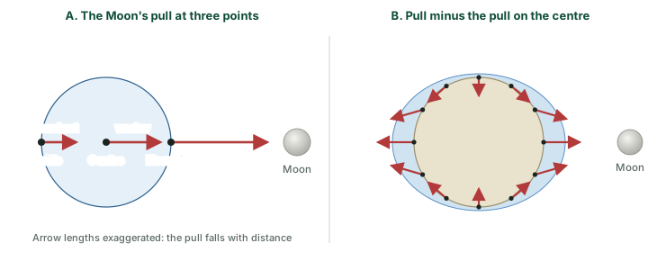
NOAA's tutorial gives a simpler account in terms of gravity and inertia. On the near side the Moon's gravitational force exceeds inertia and the water is pulled towards the Moon. On the far side, "inertia exceeds the gravitational force, and the water tries to keep going in a straight line, moving away from the Earth, also forming a bulge". "Over the rest of the globe gravity and inertia are in relative balance" (NOAA, Gravity, Inertia, and the Two Bulges).
Key idea
A tide is raised not by the Moon's pull as such but by how much that pull differs from one side of the Earth to the other. That is why there are two bulges, on opposite sides, and why distance matters so much (Section 8.5).
The timing of tides: the lunar day
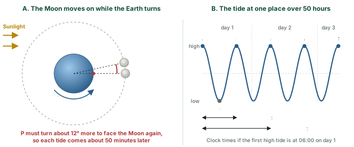
The Earth turns once a day beneath the two bulges, so a place on the coast passes through high water twice and low water twice. The cycle does not take 24 hours, though. NOAA defines the lunar day, or tidal day, as the time a place takes to come back to the same position under the Moon, and notes that "a lunar day is 24 hours and 50 minutes". The reason: "The lunar day is 50 minutes longer than a solar day because the moon revolves around the Earth in the same direction that the Earth rotates around its axis." (NOAA, Frequency of Tides: The Lunar Day).
The diagram below (A) shows this. In one day the Moon moves about 12° along its orbit relative to the Sun (360° ÷ 29.53 days), so a point that faced the Moon yesterday must turn a little further today to face it again. The two bulges pass in each lunar day, so, in NOAA's words, "High tides occur 12 hours and 25 minutes apart. It takes six hours and 12.5 minutes for the water at the shore to go from high to low, or from low to high." (NOAA, Frequency of Tides: The Lunar Day). The result, seen from the shore, is that the tides come about 50 minutes later each day (diagram below (B)).
Worked example: When is the next high tide?
High tide at a port is at 06:00 on Monday. Estimate the times of the next two high tides.
- In 29.53 days (one synodic month) the Earth turns 29.53 times relative to the Sun, but only 28.53 times relative to the Moon, because the Moon has gone once round the Earth in the same direction.
- Lunar day = 24 h × 29.53 ÷ 28.53 = 24.84 h = about 24 h 50 min.
- Check with the diagram above (A): the Earth turns 15° an hour, so the extra 12.2° takes about 49 minutes; the Moon moves on a little in that time too, which brings the delay to about 50 minutes.
- Half a lunar day = 12.42 h = about 12 h 25 min, the gap between high tides.
- High tides: 06:00 Monday, then 18:25 Monday, then 06:50 Tuesday. Low tides fall about halfway between: 12:13 and about 00:38.
Answer: About 18:25 on Monday and about 06:50 on Tuesday. Real ports differ from this average, and tide tables give the actual times.
Real tides depart from this simple rhythm. NASA notes that "Earth's spin carries the tidal bulge forward", so "the high tide bulges are never directly lined up with the Moon, but a little ahead of it" (NASA Science, Tides). Continents, ocean depths and the shape of each coast change the times and heights further. As NOAA puts it, "Detailed forecasts are available for high and low tides in all sea ports, but are specific to local conditions" (NOAA, Where is the highest tide?).
Tide timings (NOAA)
- Lunar day (tidal day): 24 h 50 min.
- High tide to high tide: 12 h 25 min.
- High to low, or low to high: 6 h 12.5 min.
- Tides come about 50 minutes later each day.
Spring tides and neap tides
The Sun raises tides too, by the same kind of difference in pull, but they are smaller. NOAA explains how the two combine: "Solar tides are about half as large as lunar tides and are expressed as a variation of lunar tidal patterns, not as a separate set of tides" (NOAA, Tidal Variations: The Influence of Position and Distance). The Sun does not give a coast an extra pair of high tides at its own times. It makes the Moon's tides bigger or smaller, depending on where the Sun and Moon stand.
Spring tides
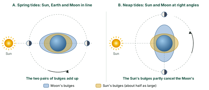
At New Moon and at Full Moon the Sun, Earth and Moon lie in a line, the arrangement NOAA's glossary calls syzygy: "whenever the Moon is lined up with the Earth and Sun in a straight Sun-Moon-Earth or Sun-Earth-Moon configuration. At these times the range of tide is greater than average" (NOAA, Tide and Current Glossary (2000)). The Sun's bulges then lie on top of the Moon's, and the solar tide "has an additive effect on the lunar tide, creating extra-high high tides, and very low, low tides" (NOAA, Tidal Variations: The Influence of Position and Distance). These are spring tides.
Neap tides
About a week later the Moon is at first or last quarter, and the Sun and Moon are at right angles as seen from the Earth (quadrature). Now "the bulge of the ocean caused by the sun partially cancels out the bulge of the ocean caused by the moon". The result is "moderate tides known as neap tides", meaning that "high tides are a little lower and low tides are a little higher than average" (NOAA, What are spring and neap tides?).
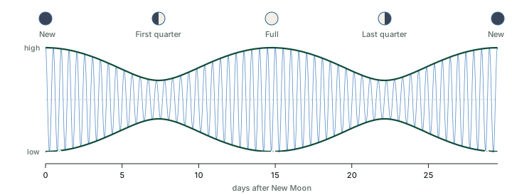
Because the Moon goes through all its phases once a month, the pattern repeats: "During each lunar month, two sets of spring tides and two sets of neap tides occur" (NOAA, Tidal Variations: The Influence of Position and Distance). The glossary describes both kinds as occurring "semimonthly" (NOAA, Tide and Current Glossary (2000)). The diagram below adds an idealised lunar tide and a solar tide about half its size: the daily rise and fall swells and shrinks through the month.
Don't confuse: Spring tide or spring season? Neap tide or low tide?
Spring tides have nothing to do with the season. NOAA says the term "has nothing to do with the season of spring" and comes from the idea of the tide "springing forth". "Spring tides occur twice each lunar month all year long without regard to the season." (NOAA, What are spring and neap tides?).
A neap tide is not a low tide. A neap tide still has its high and low waters; the difference between them, the range, is smaller.
Spring tides and neap tides compared
| Spring tides | Neap tides | |
|---|---|---|
| Moon's phase | New Moon and Full Moon | First quarter and last quarter |
| Line-up | Sun, Earth and Moon in a line (syzygy) | Sun and Moon at right angles as seen from the Earth (quadrature) |
| Sun's bulges | Add to the Moon's | Partly cancel the Moon's |
| Tidal range | Greater than average: higher high tides, lower low tides | Less than average: high tides a little lower, low tides a little higher |
| How often | Twice each lunar month | Twice each lunar month, about a week after each spring tide |
NOAA, Tide and Current Glossary (2000) (syzygy; quadrature; spring and neap tides "semimonthly"); NOAA, Tidal Variations: The Influence of Position and Distance; NOAA, What are spring and neap tides?.
Remember
- New Moon or Full Moon: spring tides, the largest range.
- First or last quarter: neap tides, the smallest range.
- Each comes twice a month, about a week apart from the other.
- A solar eclipse needs a New Moon and a lunar eclipse a Full Moon (see the section on Eclipses), so eclipses always come at spring-tide times.
One tide a day or two: daily patterns
The two-bulge picture promises every coast two equal high tides a day. NOAA says that would hold only on an ideal planet: "If the Earth were a perfect sphere without large continents, all areas on the planet would experience two equally proportioned high and low tides every lunar day." The real continents "block the westward passage of the tidal bulges as the Earth rotates", and the tides "establish complex patterns within each ocean basin that often differ greatly from tidal patterns of adjacent ocean basins or other regions of the same ocean basin" (NOAA, Types and Causes of Tidal Cycles). NASA adds the depth of the ocean to the list: tides are "also affected by the presence of continents, the shape of the Earth, the depth of the ocean in different locations, and more" (NASA Science, Tides).
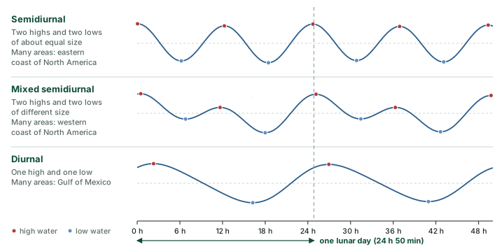
"In general, most areas have two high tides and two low tides each day" (NOAA, Types and Causes of Tidal Cycles). NOAA sorts the daily patterns into three types, each counted over a lunar day of 24 h 50 min:
- Semidiurnal ("half-daily"): "two high and two low tides of approximately equal size every lunar day". NOAA's example is many areas on the eastern coast of North America.
- Mixed semidiurnal: "two high and two low tides of different size every lunar day". Example: many areas on the western coast of North America.
- Diurnal ("daily"): "one high and one low tide every lunar day". Example: many areas in the Gulf of Mexico.
Definitions and examples: NOAA, Types and Causes of Tidal Cycles.
Why the two high tides of a day can differ
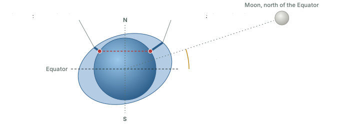
NOAA's glossary calls the gap between the two highs (or the two lows) of a day the diurnal inequality: "The difference in height of the two high waters or of the two low waters of each tidal day". It ties the gap to the Moon's declination, its angle north or south of the Equator: "the inequality tends to increase with increasing declination, either north or south, and to diminish as the Moon approaches the Equator" (NOAA, Tide and Current Glossary (2000)).
The diagram below shows why. The bulges point towards and away from the Moon. When the Moon is north of the Equator, the bulge under it is centred north of the Equator and the opposite bulge south of it. A place in the northern hemisphere passes through the thick middle of one bulge and, about 12 hours later, only the thin edge of the other, so one high tide is higher than the next. When the Moon is over the Equator, both bulges are centred on the Equator and the two highs come out nearly equal.
Tide scientists split a tide into regular parts called constituents, each with its own speed. The glossary lists the principal lunar semidiurnal constituent (M2), the principal solar semidiurnal constituent (S2), and two diurnal ones, K1 and O1, which together express "the effect of the Moon's declination" and "account for diurnal inequality and, at extremes, diurnal tides" (NOAA, Tide and Current Glossary (2000)). Comparing the sizes of the two groups gives a simple test of the type of tide.
Type of tide from the sizes of its constituents
| Ratio (K1 + O1) ÷ (M2 + S2) | Type of tide | Ratio of the curves in the diagram above |
|---|---|---|
| Less than 0.25 | Semidiurnal | 0.08 (top curve) |
| 0.25 to 1.5 | Mixed, mainly semidiurnal | 0.81 (middle curve) |
| 1.5 to 3.0 | Mixed, mainly diurnal | not drawn |
| Greater than 3.0 | Diurnal | 9.0 (bottom curve) |
NOAA, Tide and Current Glossary (2000), "type of tide" (classification after Dietrich, using the amplitudes of the constituents). Last column computed from the illustrative amplitudes of the diagram above.
Don't confuse: Semidiurnal, mixed, diurnal
Semidiurnal means two tides each lunar day, diurnal one. A mixed tide still has two highs and two lows; they are of different size.
The count is per lunar day of 24 h 50 min, not per calendar date. Because the highs come about 50 minutes later each day, a coast with two high tides a lunar day now and then has only one high tide on a calendar date. If one date has highs at 11:34 and 23:59, the next date has only one, at 12:24, and the date after that begins with a high at 00:49 (12 h 25 min steps).
Why the Moon beats the Sun
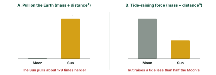
The Sun is far more massive than the Moon, and its gravity holds the Earth in its orbit. NOAA: "Based on its mass, the sun's gravitational attraction to the Earth is more than 177 times greater than that of the moon to the Earth" (NOAA, What Causes Tides). Yet the Moon raises the bigger tides. The reason is the one met in Section 8.1: a tide depends not on the pull itself but on how much the pull changes from one side of the Earth to the other, and that change dies away faster with distance than the pull does. In NOAA's words, "Gravitational attractive forces only vary inversely to the square of the distance between the objects", while "Tidal generating forces vary inversely as the cube of the distance from the tide generating object" (NOAA, What Causes Tides).
So distance counts for more than mass. NOAA again: "Although the sun is 27 million times more massive than the moon, it is 390 times further away from the Earth than the moon." Dividing 27 million by 390 cubed, about 59 million, leaves a little under one half. NOAA's conclusion: "the sun’s tide-generating force is about half that of the moon, and the moon is the dominant force affecting the Earth’s tides" (NOAA, What Causes Tides). NASA puts it as "a little less than half of the Moon’s tide-generating force" (NASA Science, Tides).
Worked example: Pull against tide, Sun against Moon
The NASA fact sheets give the Sun's mass as 1,988,400 × 1024 kg at a mean distance of 149.6 million km, and the Moon's as 0.07346 × 1024 kg at an average distance (semimajor axis) of 384,400 km. Compare (a) their pulls on the Earth and (b) their tide-raising forces.
- Mass ratio: 1,988,400 ÷ 0.07346 = 27.07 million (masses in 1024 kg).
- Distance ratio: 149.6 million km ÷ 384,400 km = 389.2.
- (a) Pull goes as mass ÷ distance²: 27.07 million ÷ 389.2² = 27.07 million ÷ 151,459 = 178.7.
- (b) Tide-raising force goes as mass ÷ distance³: 27.07 million ÷ 389.2³ = 27.07 million ÷ 58.94 million = 0.46.
Answer: The Sun pulls the Earth about 179 times harder than the Moon, but its tide-raising force is only about 0.46 of the Moon's. Both agree with NOAA ("more than 177 times"; "about half").
Why the cube? Do the numbers
Compare the pull on the side of the Earth facing each body with the pull on the Earth's centre, one Earth radius (6,371 km) farther away. Pull falls as distance squared, so:
- Moon: (384,400 ÷ 378,029)² = 1.034. The near side is pulled 3.4% harder than the centre.
- Sun: (149.6 million ÷ 149,593,629)² = 1.000085. The near side is pulled only 0.0085% harder.
- The Sun's pull is 178.7 times the Moon's, so its extra pull on the near side is 178.7 × 0.0085% = 1.52% of the Moon's pull, against the Moon's own 3.4%: a ratio of about 0.45.
That is close to the 0.46 worked out above; the cube rule is a close approximation. The difference is the pull (which falls as distance squared) times a share of about 2 × radius ÷ distance (which falls as distance once more): distance cubed in all.
Remember
- Pull on the Earth: mass ÷ distance². The Sun wins, about 179 to 1.
- Tide-raising force: mass ÷ distance³. The Moon wins; the Sun's is about half.
- So the Moon sets the rhythm of the tides, and the Sun makes them bigger (spring) or smaller (neap).
What makes a tide big
The phase of the Moon is only one of the things that set the size of a tide. NOAA: "Tidal highs and lows depend on a lot of different factors. The shape and geometry of a coastline play a major role, as do the locations of the Sun and Moon. Storm systems at sea and on land also shift large quantities of water around and affect the tides." (NOAA, Where is the highest tide?).
Distance: perigee and apogee
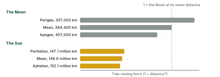
The Moon's orbit is an ellipse, so "the distance between them varies by about 31,000 miles over the course of a month". Once a month, at perigee (closest), "tide-generating forces are higher than usual, producing above-average ranges in the tides"; "About two weeks later", at apogee (farthest), the ranges "are less than average". The Earth's distance from the Sun works the same way over a year: ranges are enhanced at perihelion, "about January 2", and reduced at aphelion, "around July 2" (NOAA, Tidal Variations: The Influence of Position and Distance). Because tide-raising force goes as 1 ÷ distance³ (Section 8.5), even these modest changes in distance count.
Worked example: How much stronger at perigee?
The NASA Moon Fact Sheet gives the Moon's distance as "roughly" 357,000 km at its closest and 407,000 km at its farthest; the Sun Fact Sheet gives the Earth-Sun distance as 147.1 to 152.1 million km. Using the cube rule, compare the tide-raising force at the nearest and farthest points.
- Change in the Moon's distance: 407,000 − 357,000 = 50,000 km = about 31,000 miles (÷ 1.609). This agrees with NOAA.
- Moon, perigee against apogee: (407,000 ÷ 357,000)³ = 1.140³ = 1.48.
- Sun, perihelion against aphelion: (152.1 ÷ 147.1)³ = 1.0340³ = 1.105.
Answer: The Moon's tide-raising force is about 48% stronger at perigee than at apogee; the Sun's is about 11% stronger in early January than in early July. These are forces, not tide heights: how much higher the water actually rises depends on the coast.
Perigean spring tides and king tides
When the two effects coincide the tides are larger still. "A perigean spring tide occurs when the moon is either new or full and closest to Earth." NOAA adds: "Typically between 6-8 times each year, the new or full moon coincides closely in time with the perigee of the moon". How much bigger they are is "location dependent", but "It is not uncommon for high tides during a perigean spring tide to be more than a foot higher than high tides during ‘apogean spring tides’", that is, more than about 30 cm. The same page also gives a smaller count ("About three or four times a year, the new or full moon coincides closely in time with the perigee") and adds: "In most cases, the difference is only a couple of inches above normal spring tides" (a few centimetres). Yet they are not always the year's highest: seasonal effects such as the thermal expansion of warmer water "can sometimes mean that some of the highest tides of the year are not perigean spring tides" (NOAA, What is a perigean spring tide?).
The very highest tides are often called king tides. That is not a scientific category: NOAA calls it "a popular, non-scientific term people often use to describe exceptionally high tides", and notes that such tides typically come at a new or full moon when the Moon is at perigee, or in certain seasons (NOAA, What is a King Tide?).
The shape of the coast
Where a place is matters too. NOAA: "The highest tides in the world can be found in Canada's Bay of Fundy at Burntcoat Head in Nova Scotia." In the United States the highest are "near Anchorage, Alaska, with tidal ranges that average around 30 feet" (about 9 m) (NOAA, Where is the highest tide?).
Don't confuse: Latitude does not make tides bigger
Many of the places with the largest tides are in Alaska, Canada and northern Europe. NOAA says this "has created a misconception that the range of tide increases with increasing latitude", and that "This is incorrect." The large ranges there come from the continents of North America, Europe and Asia crowding together in the northern high latitudes; that "constriction" of the oceans raises the range. In the high southern latitudes, where the continents are not pressed together, "tidal ranges are not increased" (NOAA, Where is the highest tide?).
What makes a tide bigger or smaller
| What changes | Effect on the tide | Source |
|---|---|---|
| Moon's phase | New or Full Moon: spring tides, larger range. First or last quarter: neap tides, smaller range. | NOAA tides06; NOAA spring and neap |
| Moon's distance | Perigee: above-average ranges. Apogee, about two weeks later: below average. | NOAA tides06 |
| Earth's distance from the Sun | Perihelion, about 2 January: ranges enhanced. Aphelion, around 2 July: reduced. | NOAA tides06 |
| Moon's declination | Moon far north or south of the Equator: the two daily highs differ most. As it nears the Equator: the difference shrinks. | NOAA glossary |
| Shape of the coast | Plays "a major role": Bay of Fundy, Anchorage. | NOAA highest tide |
| Storms | Shift large quantities of water and change the tides. | NOAA highest tide |
| Season | Seasonal effects, such as the thermal expansion of warmer water, can mean that some of the highest tides of the year are not perigean spring tides. | NOAA perigean spring tide |
NOAA, Tidal Variations: The Influence of Position and Distance; NOAA, What are spring and neap tides?; NOAA, Tide and Current Glossary (2000) ("diurnal inequality"); NOAA, Where is the highest tide?; NOAA, What is a perigean spring tide?.
Using the tides
Knowing when the water will be high or low matters to many people. NOAA: "Navigating ships through shallow water ports, intracoastal waterways and estuaries requires knowledge of the time and height of the tides as well as the speed and direction of the tidal currents." "Commercial and recreational fishermen use their knowledge of the tides and tidal currents to help them improve their catches." For ecologists, tidal mixing of near-shore waters is where "pollutants are removed and nutrients are recirculated", and "Tidal currents also move floating animals and plants to and from breeding areas in estuaries to deeper waters" (NOAA, The Importance of Monitoring the Tides and Their Currents). The strip of shore that the tides cover and uncover is the intertidal zone, "the area where the ocean meets the land between high and low tides" (NOAA, What is the intertidal zone?).
Tidal energy: the barrage
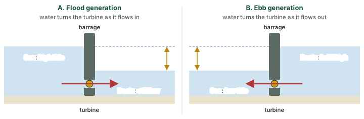
Tides can also make electricity. The best-known method is a barrage: a wall across an estuary or bay, with turbines set in it and gates to let water in or out. The tide makes the water level on one side differ from the other, and that difference in height, the head, drives water through the turbines. South Korea's Sihwa Lake plant generates "on tidal inflows" into its basin, that is, on the flood tide. Another way, described for Canada's small Annapolis plant, is to close the gates while the rising tide fills the basin, then open them and generate "when a head of 1.6m or more is created" as the tide falls, that is, on the ebb (power-technology.com, "Tidal giants – the world’s five biggest tidal power plants" (2014; archived copy), 2014).
Two large tidal barrages
| Plant | Capacity | Opened | Details |
|---|---|---|---|
| Sihwa Lake, South Korea | 254 MW | August 2011 | Ten 25.4 MW submerged bulb turbines; generates on tidal inflows into a 30 km² basin; uses a seawall of about 12.5 km built in 1994 |
| La Rance, Brittany, France | 240 MW | 1966 (built 1961 to 1966) | 24 reversible bulb turbines of 10 MW each; a 145.1 m barrage with six gates and a 163.6 m dyke; average tidal range at the site 8.2 m |
power-technology.com, "Tidal giants – the world’s five biggest tidal power plants" (2014; archived copy): a secondary source, figures as of 2014. It called Sihwa "the world’s biggest tidal power plant" and La Rance "the world’s oldest and second biggest tidal power station" at that time. Check: 10 × 25.4 = 254 MW and 24 × 10 = 240 MW (computed).
India's tidal energy potential
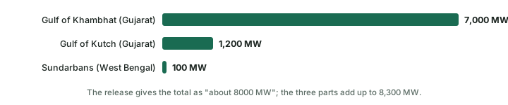
In the Rajya Sabha on 2 January 2018, the Minister of State for Power and New & Renewable Energy said in a written reply that, "as per a study conducted by the Indian Institute of Technology, Chennai, in association with CRISIL", India has "an estimated potential of about 8000 MW of tidal energy, with 7000 MW in the Gulf of Kambhat, 1200 MW in the Gulf of Kutch in Gujarat, and about 100 MW in the Gangetic delta in Sunderbans in West Bengal" (PIB (MNRE), 2 January 2018). The Gulf of Kambhat is the Gulf of Khambhat (Cambay), and Sunderbans is the Sundarbans. A later release, issued on 22 August 2019 when ocean energy was declared renewable energy, gives the "Total identified potential of Tidal Energy" as "about 12455 MW", in the Khambhat and Kutch regions and in "large backwaters, where barrage technology could be used" (PIB, 22 August 2019). It is the more recent official figure; 8,000 MW is the estimate of the IIT Chennai and CRISIL study.
Don't confuse: Potential is not power
An estimated potential is not installed capacity. The same 2018 reply said that "tidal energy cannot be presently harnessed on commercial basis due to high capital cost ranging from Rs. 30 crores to 60 crores per MW" (PIB (MNRE), 2 January 2018).
Remember
- A tide needs a difference in water level (a head) to make power.
- Flood generation uses the incoming tide (Sihwa Lake); ebb generation holds water back and uses the falling tide.
- India: about 8,000 MW (study reported in 2018, mostly in the Gulf of Khambhat) and about 12,455 MW of identified potential (PIB, 2019); not commercially harnessed in 2018 because of cost.
Sources
Each table and data figure names its source beneath it. The main documents are collected here, with a date where the source carries one. Figures not listed under image credits were drawn for this page from the data and formulas stated in their source lines.
Main sources
| Topic | Source |
|---|---|
| Planets, the Sun and the Earth | NASA Planetary Fact Sheet (18 Mar 2025); NASA Earth Fact Sheet; NASA, Earth facts; NASA, Sun facts |
| Tides | NOAA tides tutorial; NOAA, spring and neap tides; NOAA, highest tides; NOAA Tides and Currents; PIB (MNRE), tidal energy potential, 2 Jan 2018; PIB, ocean energy declared renewable, 22 Aug 2019 |
Image credits
| Image | Credit and licence |
|---|---|
| All other figures | Drawn for this page from the data and formulas given in their source lines. |