 BharatNotes
Part 3 of 6 of the Astronomical Geography notes. The overview page has the quick revision, exam strategy and key terms for all six parts.
Cross-paper relevance
- GS1 (Geography, primary): latitude and longitude, great circles, the Prime Meridian, local and standard time, Indian Standard Time, time zones and the International Date Line
- GS3 (Science and technology): the atomic clocks of the NavIC satellites, the IRNSS-1F clock that stopped in March 2026, and NVS-02, which could not be raised to its working orbit
Latitude and Longitude
A sphere has no corners and no edges, so to say where a place is we need a grid drawn on it. The grid of latitude and longitude does this with two angles measured from the centre of the Earth. This section builds the grid from first principles, shows why a degree of longitude shrinks towards the poles while a degree of latitude barely changes, and places India on it.
Two angles fix any place
Picture a line from the centre of the Earth to a place P on the surface. Two angles describe the direction of that line, and so the position of P.
- Latitude (symbol φ, "phi") is the angle between the line to P and the plane of the Equator. It runs from 0° at the Equator to 90° N at the North Pole and 90° S at the South Pole.
- Longitude (symbol λ, "lambda") is the angle, measured around the Earth's axis, between the half-plane of a reference meridian and the half-plane of the meridian through P. The reference is the Prime Meridian through Greenwich. Longitude runs from 0° to 180° east and 0° to 180° west.
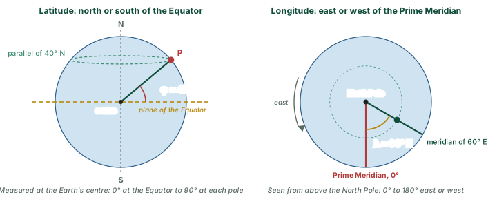
Each degree is divided into 60 minutes (′) and each minute into 60 seconds (″), so a position is written like 23°30′ N, 82°30′ E. Always give the letter: 30° on its own does not say which hemisphere.
Joining all places with the same latitude gives a circle round the globe called a parallel, because it runs parallel to the Equator. Joining all places with the same longitude gives a half-circle from pole to pole called a meridian. Together they form the graticule, the grid you see on a globe.
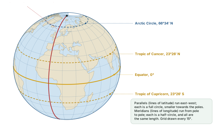
Parallels and meridians compared
| Parallels (latitude) | Meridians (longitude) | |
|---|---|---|
| Measures | Latitude: angle north or south of the Equator | Longitude: angle east or west of the Prime Meridian |
| Range | 0° to 90° N or S | 0° to 180° E or W |
| Shape | Full circles | Half-circles from pole to pole |
| Length | Shrink towards the poles: the Equator is 40,075 km round; the poles are points | All equal: each about 20,004 km from pole to pole |
| Spacing | Almost equal: about 111 km per degree everywhere | Widest at the Equator (111.3 km per degree), meeting at the poles |
| Direction they run | East-west | North-south |
| Reference line | Equator (fixed by the Earth's spin axis) | Prime Meridian (chosen by agreement) |
| Great circle? | Only the Equator | Every meridian, joined with its opposite meridian |
| Used for | Climate belts, heat zones, length of day | Time and time zones (see the section on Longitude and Time) |
Lengths computed from the WGS 84 ellipsoid, EPSG:7030 (a = 6,378.137 km, 1/f = 298.257223563): Equator = 2πa; meridian = numerical sum of the meridian arc from 90° S to 90° N.
A natural zero and an agreed zero
Latitude is fixed by nature: the Equator is the circle midway between the poles of the Earth's spin. Longitude has no natural zero. Any meridian could serve, so the zero had to be agreed, which is why there was an international conference about it (section 5.5).
Don't confuse: Length versus spacing
Parallels get shorter towards the poles, but the spacing between them stays almost the same. Meridians are all the same length, but the spacing between them shrinks to nothing at the poles. Questions often swap "length" and "spacing".
Great circles and small circles
Slice a sphere with a flat plane and the cut edge is always a circle. If the plane passes through the centre of the Earth, the circle is a great circle: it is the largest circle the sphere can carry and it cuts the globe into two equal halves. If the plane misses the centre, the circle is a small circle.
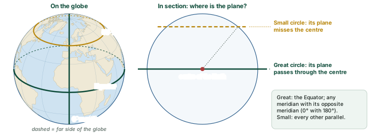
The Equator is the only parallel that is a great circle; every other parallel is a small circle. A single meridian is only a half-circle, but a meridian and its opposite meridian (for example 0° and 180°, or 82°30′ E and 97°30′ W) together make a great circle. Great circles matter for travel: the shortest path between two points on a sphere runs along the great circle through them. The section on Maps and Projections shows why such routes look curved on most flat maps.
Don't confuse: Not every famous line is a great circle
The International Date Line is not a great circle. It follows the 180° meridian only in open ocean and zigzags round island groups and eastern Russia (see the section on Longitude and Time). The Tropics and polar circles are small circles.
The important parallels
Five parallels have names. The Equator is fixed by the Earth's spin axis; the other four come from the tilt of that axis, which is about 23.44° (NASA). The Sun can be directly overhead at noon only between the latitudes equal to the tilt, so the Tropics lie at about 23.44° (written 23°26′). The Arctic and Antarctic Circles lie the same angle from the poles, at 90° − 23.44° = 66.56° (66°34′). NCERT rounds the Tropics to 23°30′ and many books use 66½° for the polar circles. The section on Seasons, Insolation and Heat Zones explains how these lines frame the seasons and heat zones; here they are simply part of the grid.
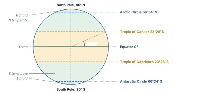
The named parallels
| Parallel | Latitude | What it marks |
|---|---|---|
| North Pole | 90° N | Northern end of the spin axis; every meridian meets here |
| Arctic Circle | 66°34′ N | Southern edge of the zone that has at least one day of 24-hour daylight (June solstice) and one of 24-hour night (December solstice) |
| Tropic of Cancer | 23°26′ N | Northernmost latitude where the noon Sun can be directly overhead (June solstice); crosses India |
| Equator | 0° | Divides the Northern and Southern Hemispheres; the only parallel that is a great circle |
| Tropic of Capricorn | 23°26′ S | Southernmost latitude where the noon Sun can be directly overhead (December solstice) |
| Antarctic Circle | 66°34′ S | Northern edge of the zone with at least one day of 24-hour daylight (December solstice) and one of 24-hour night (June solstice) |
| South Pole | 90° S | Southern end of the spin axis |
Latitudes computed from the axial tilt of 23.44° (NASA); the day-and-night conditions are the geometric ones, ignoring the bending of sunlight by the atmosphere.
How long is one degree?
If the Earth were a perfect sphere, every degree of latitude would have the same length. It is not: the Earth is slightly flattened at the poles (see the section on Shape and Size of the Earth), and the standard model used by GPS, the WGS84 ellipsoid, has an equatorial radius of 6,378.137 km and a flattening of 1/298.257223563. On that shape the length of a degree depends on latitude, and the two kinds of degree behave very differently.
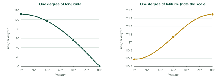
Length of one degree at different latitudes (km)
| Latitude | 1° of latitude (north-south) | 1° of longitude (east-west) | Whole parallel (km round) |
|---|---|---|---|
| 0° | 110.57 | 111.32 | 40,075 |
| 15° | 110.65 | 107.55 | 38,718 |
| 30° | 110.85 | 96.49 | 34,735 |
| 45° | 111.13 | 78.85 | 28,385 |
| 60° | 111.41 | 55.80 | 20,088 |
| 75° | 111.62 | 28.90 | 10,405 |
| 90° | 111.69 | 0.00 | 0 |
Computed from the WGS 84 ellipsoid, EPSG:7030 with the formulas in the diagram above. Whole parallel = 360 × the length of 1° of longitude.
Why a degree of latitude is longer near the poles
A degree of latitude is the distance you must walk along a meridian for the overhead direction to swing by 1°. Where the Earth is flatter, its surface curves more gently, so you must walk farther for the same 1° swing. The Earth is flattest near the poles, so degrees of latitude are longest there (111.69 km) and shortest at the Equator (110.57 km). Degrees of longitude shrink for a quite different reason: the meridians converge.
Worked example: distance along a parallel
Two towns lie on the parallel of 60° N, 10° of longitude apart. How far apart are they along the parallel? How does this compare with two places 10° apart on the Equator?
- At 60° N one degree of longitude is 55.80 km (see the table of degree lengths above).
- 10 × 55.80 ≈ 558 km.
- On the Equator: 10 × 111.32 ≈ 1,113 km.
Answer: About 558 km, almost exactly half the 1,113 km on the Equator, because cos 60° = 0.5. (The shortest path between the towns is a great circle and is a little shorter still.)
The Prime Meridian and the 1884 conference
Because longitude has no natural zero, nations long used different starting meridians, often running through their own capitals or observatories. In October 1884 the International Meridian Conference met in Washington to choose one. Its second resolution proposed to governments "the adoption of the meridian passing through the centre of the transit instrument at the Observatory of Greenwich as the initial meridian for longitude." The vote was 22 in favour, 1 against (San Domingo) and 2 abstaining (Brazil and France), out of 25 nations voting.
A further resolution settled the counting: "That from this meridian longitude shall be counted in two directions up to 180 degrees, east longitude being plus and west longitude minus." The conference also proposed a universal day starting at midnight on the Greenwich meridian, for purposes where it was convenient, without interfering with local or standard time.
Don't confuse: What 1884 did and did not do
The 1884 conference chose the Prime Meridian and the way of counting longitude. It did not pass a resolution fixing the International Date Line, and it did not set up the world's time zones. Countries adopted standard times on their own, and they still choose their own dates (see the section on Longitude and Time).
Remember
- Prime Meridian: 0°, through Greenwich.
- Opposite meridian: 180°, in the Pacific.
- East longitudes run to 180° E, west longitudes to 180° W; 180° E and 180° W are the same line.
Quotations and vote: International Conference Held at Washington for the Purpose of Fixing a Prime Meridian and a Universal Day, October 1884: Protocols of the Proceedings.
India on the grid
NCERT gives the extent of India's mainland as 8°4′ N to 37°6′ N and 68°7′ E to 97°25′ E, so it spans about 30° in each direction. Yet the east-west extent is the shorter of the two in kilometres. The reason is section 5.4: a degree of latitude is always about 111 km, but at India's latitudes a degree of longitude is shorter (about 102 km along the Tropic of Cancer, computed).
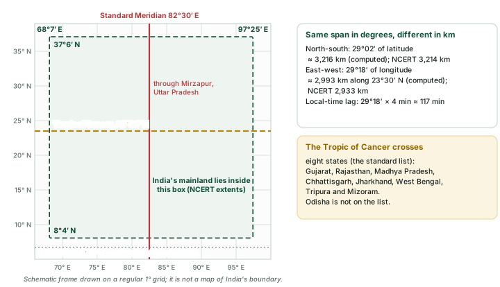
The Tropic of Cancer (23°30′ N in NCERT) divides India into two almost equal parts. The Standard Meridian of India, 82°30′ E, passes through Mirzapur in Uttar Pradesh, near the middle of the country's longitudes; the section on Longitude and Time shows why it gives Indian Standard Time an offset of 5 hours 30 minutes. Because the mainland spans 29°18′ of longitude, local solar time at its eastern and western ends differs by about 117 minutes; NCERT puts it as a time lag of two hours from Gujarat to Arunachal Pradesh. The southern boundary reaches 6°45′ N in the Bay of Bengal (NCERT Class XI), south of the mainland. NCERT Class IX names the southernmost point of the Indian Union, Indira Point, and notes that it "got submerged under the sea water in 2004 during the Tsunami".
Exam tip
Learn the eight states the Tropic of Cancer crosses in west-to-east order: Gujarat, Rajasthan, Madhya Pradesh, Chhattisgarh, Jharkhand, West Bengal, Tripura, Mizoram. A common trap is Odisha, which the Tropic does not cross.
What the two extents mean
Latitude tells you about climate and day length: India's south lies in the tropics and its north in the subtropics. Longitude tells you about time: a span of about 30° of longitude means about two hours of difference in local time across the country.
Longitude and Time
Longitude does more than locate a place: it sets the place's clock. Relative to the Sun, the Earth turns through 360° in one mean solar day of 24 hours, so every degree of longitude stands for four minutes of time. This section turns that single rule into a method for any time question, and then explains standard time, Indian Standard Time, the world's time zones and the International Date Line.
The Earth as a clock
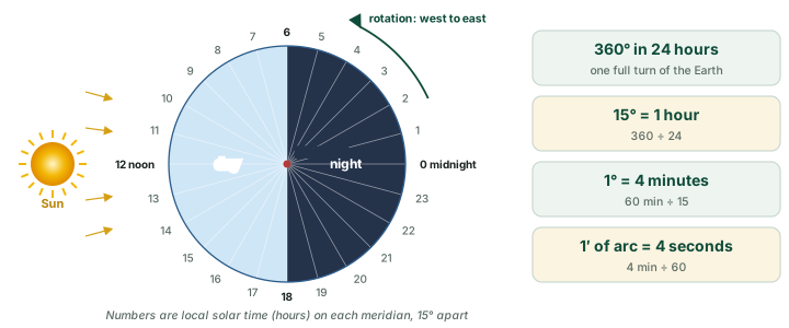
The Earth turns on its axis from west to east: seen from above the North Pole, it turns anticlockwise. As it turns, each meridian in turn faces the Sun. The moment the Sun crosses a meridian, and stands highest in the sky for every place on it, is local noon for that meridian. Time counted from that noon is local time, and because each meridian faces the Sun at a different moment, each meridian has its own local time.
Clocks follow the mean solar day of 24 hours, the average interval from one local noon to the next, not the sidereal rotation of 23 h 56 min 4 s measured against the stars (see the section on Rotation and Revolution). Clock time based on this steady 24-hour day is local mean time, and all the time questions in this section use it. In one mean solar day the Earth turns through 360° relative to the Sun, which gives the conversion rates in the diagram below.
Remember
East is ahead, west is behind. A place 1° east of another turns into the sunlight 4 minutes earlier, so its local time is 4 minutes ahead. A place 1° west is 4 minutes behind. Fifteen degrees east is a full hour ahead.
Exam tip
Learn the conversions both ways: 1° = 4 min and 1 min = 15′ of arc; 15° = 1 h and 1 h = 15°. Most time questions are one multiplication or one division by 4, followed by a careful check of direction.
Finding the time at another longitude
Every local-time question reduces to the same four steps. First find the difference in longitude: if both places are east of Greenwich, or both west, subtract one longitude from the other; if one is east and the other west, add them, because the Prime Meridian lies between them. Then turn degrees into time at 4 minutes per degree. Then decide the direction: add the time if the place you want lies east of the place you know, subtract it if it lies west. Finally, check whether the answer has run past midnight in either direction, which changes the date.
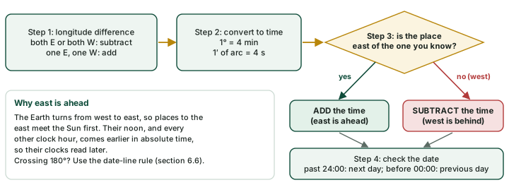
Worked example: from Greenwich to 82°30′ E
It is 12:00 noon, local time, at Greenwich (0°). What is the local time at 82°30′ E?
- Difference in longitude: 82°30′ − 0° = 82.5°.
- Time: 82.5 × 4 min = 330 min = 5 h 30 min.
- The place is east of Greenwich, so add: 12:00 + 5 h 30 min.
Answer: 17:30, that is 5:30 p.m. This is why Indian Standard Time is 5 h 30 min ahead of UTC (section 6.4).
Worked example: across the Prime Meridian
It is 10:00 at 75° E. What is the local time at 45° W?
- One place is east and one west, so add: 75° + 45° = 120°.
- Time: 120 × 4 min = 480 min = 8 h.
- 45° W lies west of 75° E, so subtract: 10:00 − 8 h.
Answer: 02:00 on the same day.
Worked example: finding longitude from a clock
At a ship, the Sun crosses the meridian (local noon) when a clock set to Greenwich time reads 15:20. What is the ship's longitude?
- Time difference: 15:20 − 12:00 = 3 h 20 min = 200 min.
- Longitude difference: 200 ÷ 4 = 50°.
- Greenwich is ahead of the ship, so the ship is west of Greenwich.
Answer: 50° W.
Worked example: when the date changes
It is 02:00 on Tuesday at 90° E. What is the local time at 60° W?
- One east, one west: 90° + 60° = 150°.
- Time: 150 × 4 min = 600 min = 10 h.
- 60° W is west, so subtract: 02:00 − 10 h takes the clock back past midnight.
Answer: 16:00 on Monday, the previous day.
Exam tip
Read the question twice: does it ask for local time or standard time? Local time changes by 4 minutes for every degree; standard time stays the same across a whole zone and jumps only at its border (section 6.3).
Local time and standard time
If every town kept its own local time, two towns only one degree apart would differ by four minutes, and a journey across a large country would need constant resetting of watches. Countries therefore choose a standard meridian and let every clock in the country, or in one zone of it, keep the local mean time of that meridian. That shared time is standard time.
The arithmetic of the 24-hour clock above decides what the offset from Greenwich will be. A standard meridian at a multiple of 15° gives a difference of a whole number of hours; one at an odd multiple of 7°30′, as 82°30′ is (11 × 7°30′), gives a difference ending in half an hour.
Local mean time, standard time and UTC
| Local mean time | Standard time | Coordinated Universal Time (UTC) | |
|---|---|---|---|
| Set by | The meridian of the place itself | One standard meridian chosen for a country or zone | The worldwide reference from which zone times are counted |
| Changes | 4 minutes for every degree east or west | Only when you cross into another zone | Does not change with place |
| In India | About 117 minutes apart between the western and eastern ends of the mainland | Indian Standard Time, one time for the whole country | IST = UTC + 5 h 30 min |
| Used for | Finding when the Sun is highest at a place | Everyday clocks in a country | Comparing times across the world |
IST = UTC + 5:30: CSIR-National Physical Laboratory, "Indian Standard Time". Single standard time for India: NCERT Class IX, Contemporary India I, ch. 1 (reprint 2025-26). Spread computed: (97°25′ − 68°7′) × 4 min.
Key idea
Local time is a fact of astronomy; standard time is a choice made by law. The Sun decides local noon at every meridian. A government decides which meridian's time its clocks will keep.
Indian Standard Time
India keeps one standard time for the whole country, Indian Standard Time (IST). The CSIR-National Physical Laboratory maintains IST and describes it as "UTC(NPLI) plus 5:30 hours". Five and a half hours is 330 minutes, and 330 ÷ 4 = 82.5, so IST is the local mean time of the meridian 82°30′ E.
The legal basis (2026). The Legal Metrology (Indian Standard Time) Rules, 2026 were notified on 27 August 2026 and published in the Official Gazette on 29 August (All India Radio, 3 Sep 2026). All India Radio had reported on 30 August (All India Radio, 30 Aug 2026): "The Department of Consumer Affairs has notified the Legal Metrology (Indian Standard Time) Rules, 2026." The rules "will come into force one hundred eighty days from the date of their publication in the Official Gazette", which falls in late February 2027 (computed).
NCERT explains the choice from India's east-west spread: "From Gujarat to Arunachal Pradesh, there is a time lag of two hours. Hence, time along the Standard Meridian of India (82°30'E) passing through Mirzapur (in Uttar Pradesh) is taken as the standard time for the whole country." The mainland runs from 68°7′ E to 97°25′ E (NCERT), whose midpoint is about 82°46′ E (computed), and 82°30′ E is the nearest meridian that gives a half-hour offset from Greenwich.
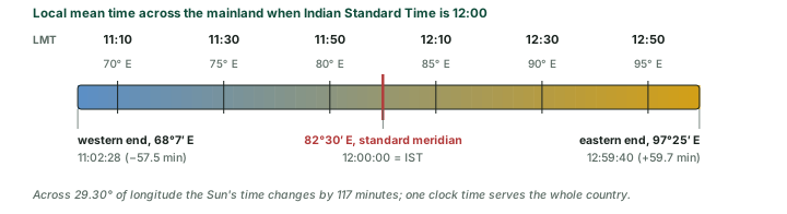
The diagram above puts numbers on NCERT's "time lag of two hours". At the western end the local mean time is 57½ minutes behind IST; at the eastern end it is almost exactly an hour ahead. In UTC terms, local mean time across the mainland runs from about UTC + 4 h 32 min to UTC + 6 h 30 min (computed), while every clock reads UTC + 5 h 30 min.
Do the numbers
Local noon (Sun highest) at the eastern end comes about 117 minutes before local noon at the western end, though both are read off the same IST clocks. That is (97°25′ − 68°7′) × 4 min = 29°18′ × 4 min = 117 min.
Exam tip
For a Mains answer on one time zone versus two, start from the arithmetic: a spread of about 29° of longitude means close to two hours between the Sun's time in the far east and the far west. Weigh the daylight argument for the north-east against the convenience of a single national time.
Time zones of the world
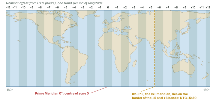
Divide the 360° of longitude by 24 hours and the globe splits into 24 bands of 15°. Each band has a central meridian at a multiple of 15° and keeps that meridian's time, so neighbouring bands differ by exactly one hour. The band centred on the Prime Meridian runs from 7°30′ W to 7°30′ E and keeps UTC; the band at 180° is cut in two, one half 12 hours ahead of UTC and the other 12 hours behind.
Don't confuse
The International Meridian Conference of 1884 proposed Greenwich as the initial meridian for longitude and proposed a universal day beginning at mean midnight at Greenwich, which, in its words, "shall not interfere with the use of local or other standard time". It did not lay out the world's time zones, and none of its resolutions defines a date line. Source: International Conference Held at Washington for the Purpose of Fixing a Prime Meridian and a Universal Day, October 1884: Protocols of the Proceedings.
The International Date Line
Travel eastward round the world and you set your watch forward one hour in each zone: 24 hours in all by the time you return. Travel westward and you set it back 24 hours. The calendar must absorb that day somewhere, and the natural place is the 180° meridian, opposite Greenwich, where the zone 12 hours ahead of UTC meets the zone 12 hours behind it. In this nominal scheme the clocks on the two sides agree, but the dates differ by one day.
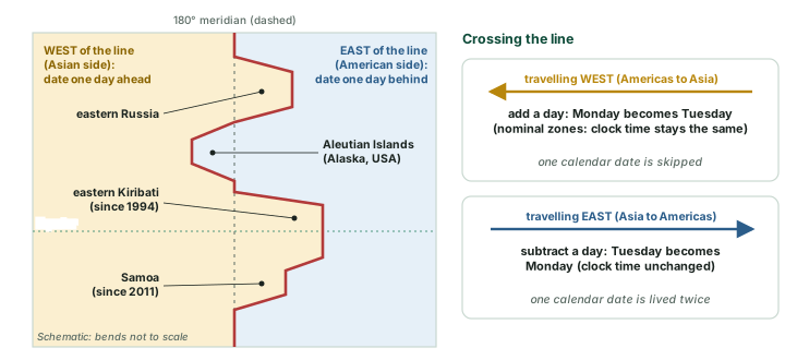
The National Oceanic and Atmospheric Administration (NOAA) of the United States describes the International Date Line as the "line of demarcation" between "two consecutive calendar dates". It follows the 180° meridian across open ocean but, in NOAA's words, "it zigzags around political borders such as eastern Russia and Alaska’s Aleutian Islands", so that a country or island group is not split between two dates.
Remember
Crossing the line westward (from the Americas towards Asia), the date goes forward one day; NOAA puts it simply: "Cross to the west and it’s one day later". Crossing eastward, the date goes back one day. In the nominal scheme the clock reads the same on both sides (UTC + 12 h and UTC − 12 h): only the date changes.
Because the line is a matter of national choice, it has moved. NOAA notes that the date line "has no legal international status and countries are free to choose the dates that they observe". Two changes in the Pacific are recorded in the international time zone database:
Two Pacific countries that changed sides of the date line
| Place | Change | Day skipped | Note |
|---|---|---|---|
| Kiribati: Line Islands (eastern Kiribati) | From UTC − 10 h to UTC + 14 h | 31 December 1994: the local date went from Friday 30 December 1994 to Sunday 1 January 1995 | Eastern Kiribati moved to the west side of the line |
| Samoa | Moved from the east side of the line to the west side | Friday 30 December 2011: Thursday 29 December 23:59:59 was followed by Saturday 31 December 00:00:00 | Tokelau also skipped 30 December 2011 |
IANA time zone database, file australasia (zones Pacific/Kiritimati and Pacific/Apia; Tokelau zone data).
Worked example: crossing the date line
A ship sailing west from Hawaii towards Japan crosses the date line at 10:00 on Monday. What are the time and date just after the crossing?
- Westward across the line: the date goes forward one day.
- In the nominal scheme the clock time is unchanged.
Answer: 10:00 on Tuesday. A ship sailing east on the same route would go from 10:00 Tuesday back to 10:00 Monday.
Don't confuse
The date line is not a great circle: it zigzags, and only the meridians 0° and 180° taken together make a great circle. It is not set by the 1884 conference, none of whose resolutions defines a date line. And it is not a legal boundary: NOAA says it "has no legal international status".
Day and night on the world map
On a globe, the line between day and night is the circle of illumination (see the section on Rotation and Revolution). Spread onto a flat world map it becomes a curve called the terminator, and its shape depends on where the Sun is overhead. The diagram below computes it for two moments in 2026 and marks the IST meridian on each.
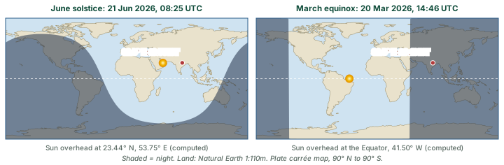
The two panels show why time and longitude go together. At any instant, the meridian under the Sun has local noon, the meridian 90° to its east is at 18:00 local time and turning into evening, and the meridian 180° away has midnight. Read the clock time at any meridian and you know where it stands on the day-night wheel of the 24-hour clock above.
Clocks in orbit: NavIC
Satellite navigation works by timing signals, so a satellite without a working clock cannot be used for positioning.
NavIC clocks (Mar 2026). ISRO said that "On 13th March 2026, [the] procured on-board atomic clock stopped functioning" on IRNSS-1F, which had completed its 10-year design life on 10 March 2026, and that the satellite would continue to provide one-way broadcast messaging. GPS World reported that only three NavIC satellites remained operational (GPS World, 16 Mar 2026).
NVS-02 (Jan 2025). NVS-02, India's second next-generation NavIC satellite, was launched by GSLV-F15 on 29 January 2025. ISRO reported that "the valves for admitting the oxidizer to fire the thrusters for orbit raising did not open", so it could not be raised to its working orbit (ISRO, GSLV-F15/NVS-02 mission page).
Sources
Each table and data figure names its source beneath it. The main documents are collected here, with a date where the source carries one. Figures not listed under image credits were drawn for this page from the data and formulas stated in their source lines.
Main sources
| Topic | Source |
|---|---|
| Shape and size | WGS84 ellipsoid (EPSG:7030) |
| Orbit, tilt, seasons | F. Espenak, perihelion and aphelion 2001-2100; F. Espenak, equinoxes and solstices 2001-2100; NASA Earth Observatory, Milankovitch |
| India: extent, time, Zero Shadow Day | NCERT Class IX, Contemporary India I, ch. 1 (reprint 2025-26); NCERT Class XI, India: Physical Environment, ch. 1 (reprint 2026-27); CSIR-NPL, Indian Standard Time; Astronomical Society of India, Zero Shadow Day |
| Prime meridian and date line | Proceedings of the International Meridian Conference, 1884; NOAA, International Date Line; IANA time zone database |
| Maps | United Nations, emblem and flag; Natural Earth 1:110m land (public domain) |
| NavIC and IST rules | ISRO, GSLV-F15/NVS-02; GPS World, 16 Mar 2026; All India Radio, 30 Aug 2026; All India Radio, 3 Sep 2026 |
Image credits
| Image | Credit and licence |
|---|---|
| World land outlines on maps | Natural Earth, 1:110m physical vectors. Public domain. |
| All other figures | Drawn for this page from the data and formulas given in their source lines. |