 BharatNotes
Part 2 of 6 of the Astronomical Geography notes. The overview page has the quick revision, exam strategy and key terms for all six parts.
Rotation and Revolution
The Earth has two motions. It spins on its axis once a day, which gives day and night, and it travels round the Sun once a year, which with its tilted axis gives the seasons. This section takes each motion in turn: which way the Earth spins and how fast the ground moves, why the day measured by the stars is four minutes shorter than the day measured by the Sun, how the spin bends winds and currents, and what shape the orbit really has. It ends with the year and the rule for leap years.
Rotation: the daily spin
The Earth spins on its axis, an imaginary line through the North and South Poles. This spin is called rotation. NCERT puts it simply: "The earth takes about 24 hours to complete one rotation around its axis." Measured against the distant stars, one turn takes 23.9345 hours, or about 23 hours 56 minutes 4 seconds (section 3.3 explains why this is a little less than 24 hours).
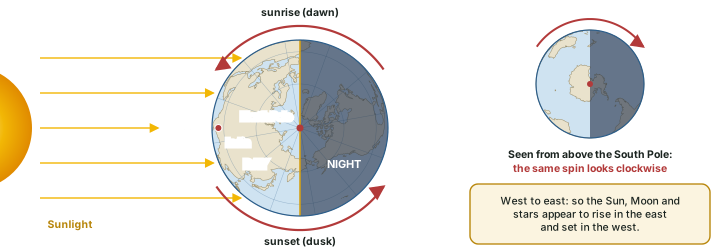
The spin is from west to east. Looked at from above the North Pole, the Earth turns anticlockwise; from above the South Pole the same spin looks clockwise. Because we are carried eastward, towards the Sun in the morning and away from it in the evening, the Sun appears to rise in the east, cross the sky and set in the west. The Moon and stars appear to move the same way for the same reason (diagram above).
From the NCERT Class VI textbook
The ancient Indian astronomer Aryabhata, NCERT notes, "had stated that ‘the earth is round and rotates on its own axis’".
Day and night: the circle of illumination
The Earth gives off no light of its own, and at any moment the Sun lights only the half of the globe that faces it. That half has day; the other half has night. The boundary between them is a circle round the globe, which NCERT defines this way: "The circle that divides the day from night on the globe is called the circle of illumination." As the Earth rotates, every place is carried across this circle twice a day: once into the light (sunrise) and once out of it (sunset). Without rotation, one half of the Earth would face the Sun for months on end.
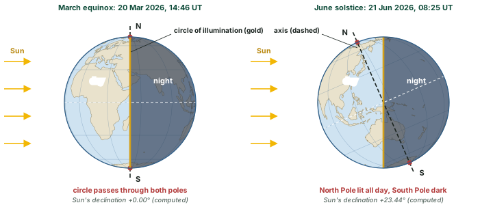
The circle of illumination always cuts the globe into two equal halves, but it is not always lined up with the axis. At an equinox the Sun is over the equator and the circle passes through both poles, so every place has roughly equal day and night. At other times the tilted axis leans one pole towards the Sun, and the circle passes beyond the poles: around the June solstice the whole area round the North Pole stays in daylight as the Earth turns, while the area round the South Pole stays dark (diagram above; the section on Seasons, Insolation and Heat Zones follows this through the year).
Don't confuse: Circle of illumination and axis
- Circle of illumination: the moving line between day and night. It divides the globe into two equal halves at every moment.
- Axis: the fixed line through the poles about which the Earth spins. The two coincide (as seen from the side) only at the equinoxes.
Two kinds of day: sidereal and solar
There are two ways to time one rotation. Against the distant stars, the Earth turns once in 23.9345 hours, or 23 hours 56 minutes 4 seconds: this is the sidereal day (from the Latin word for star). Against the Sun, from one noon to the next, the day lasts 24 hours on average: this is the solar day, the day our clocks keep. NASA lists both numbers for the Earth, a sidereal rotation period of 23.9345 hours and a length of day of 24.0000 hours.
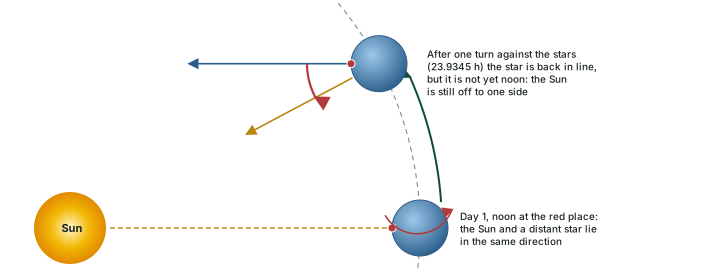
The difference comes from revolution. While the Earth spins once, it also moves a little along its orbit, about 360° ÷ 365.256 days = 0.986° each day. After one turn against the stars, the Sun is therefore not quite back in the same place in the sky, and the Earth has to turn that extra fraction of a degree before it is noon again (diagram below). Both motions go the same way, anticlockwise as seen from above the North Pole, which is why the solar day is the longer one.
Worked example: Where do the 4 minutes come from?
The Earth turns 360° in 23.9345 hours and moves about 0.9856° along its orbit in a day. How much longer is the solar day than the sidereal day?
- Extra angle the Earth must turn: about 0.9856°.
- Time for that angle: 23.9345 h × 0.9856 ÷ 360 = 0.0655 h = 3.93 min.
- Sidereal day + extra: 23 h 56 min 4 s + 3 min 56 s = 24 h 00 min.
Answer: about 3 minutes 56 seconds, which is why a given star rises about 4 minutes earlier each night (computed).
Don't confuse: Sidereal day and solar day
- Sidereal day (23 h 56 min 4 s): one turn measured against the stars. This is the true period of rotation.
- Solar day (24 h on average): one turn measured against the Sun, noon to noon. Clocks, calendars and time zones use this one.
How fast does the ground move?
Every place on the Earth turns once in the same sidereal day, but places travel round circles of very different sizes. A point on the equator goes round the full circumference, 2π × 6,378.137 km = 40,075 km, in 23.9345 hours, so it moves at about 1,674 km/h (465 m/s). Away from the equator the circle of latitude is smaller: its radius is the Earth's radius times the cosine of the latitude. At 60° the circle has half the radius, so the ground moves at half the speed, and at the poles it only turns on the spot (diagram below).
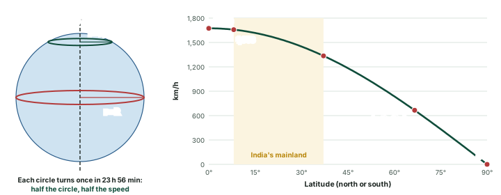
Speed of the ground due to rotation
| Latitude | Place on the globe | km/h | m/s |
|---|---|---|---|
| 0° | Equator | 1,674 | 465 |
| 8°4′ | Southern limit of India's mainland | 1,658 | 460 |
| 10° | 1,649 | 458 | |
| 20° | 1,573 | 437 | |
| 23°26′ | Tropic of Cancer | 1,536 | 427 |
| 30° | 1,450 | 403 | |
| 37°6′ | Northern limit of India's mainland | 1,335 | 371 |
| 40° | 1,283 | 356 | |
| 45° | 1,184 | 329 | |
| 50° | 1,076 | 299 | |
| 60° | 837 | 233 | |
| 66°34′ | Arctic Circle | 666 | 185 |
| 70° | 573 | 159 | |
| 80° | 291 | 81 | |
| 90° | North Pole | 0 | 0 |
Computed: 2π × 6,378.137 km × cos(latitude) ÷ 23.9345 h, on a sphere. The Tropic is taken at 23°26′, from the axial tilt of 23.44°.
Do the numbers: Why the numbers are a little rounded
The table treats the Earth as a sphere. On the WGS84 ellipsoid the circle of latitude is slightly larger than on a sphere of the equatorial radius, by about 0.17% at 45° (computed from the ellipsoid's eccentricity), which changes the speeds by only a few km/h.
We do not feel this motion because the ground, the air and we ourselves all move together at a steady speed. What we do notice are its effects: day and night, and the bending of winds and currents described next.
The Coriolis effect
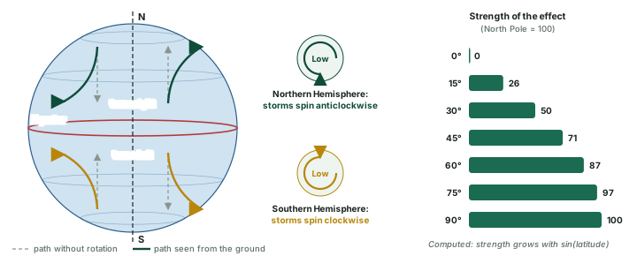
Rotation also changes the path of anything that moves freely over long distances across the Earth, such as winds and ocean currents. Seen from the rotating ground, such a body does not keep to a straight line: NCERT's Class XI textbook says the force due to rotation "deflects the wind to the right direction in the northern hemisphere and to the left in the southern hemisphere." This is the Coriolis effect (called the Coriolis force in NCERT), named after the French physicist Gaspard-Gustave de Coriolis. NOAA describes the same deflection for ocean currents.
Why the turn happens
A simple picture for winds moving north or south: the ground at the equator moves east at about 1,674 km/h, but the ground at 30° N moves at about 1,450 km/h (see the table of rotation speeds above). Air that sets off northward from the equator keeps its faster eastward motion, so it runs ahead of the slower ground beneath it and curves towards the east, which is to its right. Air moving towards the equator lags behind the faster ground and curves towards the west, again to its right. In the Southern Hemisphere the same reasoning gives a turn to the left.
The strength of the effect depends on latitude. NCERT states that the Coriolis force "is maximum at the poles and is absent at the equator." More exactly, it is proportional to the sine of the latitude, not to the latitude itself: the effect at 30° is already half of its value at the pole (diagram above, right). The rate is 2Ω sin(latitude), where Ω is the Earth's rate of spin, 7.2921 × 10⁻⁵ radians per second (computed from the sidereal day); at the poles this gives 1.458 × 10⁻⁴ per second.
The effect shapes several things you will meet in climatology and oceanography:
- Cyclones. IMD explains that winds flowing in to fill a low are "deflected to the right and a counter-clockwise rotation will be initiated" north of the equator, with the opposite south of it. NOAA NESDIS gives the same rule for storms.
- No cyclones on the equator. NCERT notes that at the equator the Coriolis force is zero, "The low pressure gets filled instead of getting intensified. That is the reason why tropical cyclones are not formed near the equator." IMD lists a distance of at least 500 km from the equator among the conditions for a tropical cyclone to form.
- Monsoon winds. NCERT's India: Physical Environment (Class XI, ch. 4 "Climate", reprint 2026-27) explains that the trade winds of the southern hemisphere cross the equator and "start blowing from southwest to northeast due to the Coriolis force", becoming the southwest monsoon.
- Ocean currents. Large currents are turned the same way, right in the north and left in the south (NOAA).
Don't confuse: Storms, yes; sinks, no
The Coriolis effect matters for winds and currents that travel hundreds of kilometres over hours or days. IMD's FAQ notes that it is far too small to decide which way water swirls down a sink or a toilet: the shape of the basin and the way the water was moving decide that.
Revolution: the path round the Sun
NCERT's Class VI book defines the second motion simply: "The movement of the earth around the sun in a fixed path or orbit is called Revolution." The path is not a perfect circle. NASA states Kepler's first law as: "each planet's orbit about the Sun is an ellipse. The Sun's center is always located at one focus of the orbital ellipse." For the Earth, though, the ellipse is very close to a circle. Its eccentricity is 0.0167 (NASA Earth Fact Sheet (updated 15 Nov 2024)), where 0 would be a perfect circle, so the Sun sits only about 2.5 million km from the centre of the orbit (computed: 149.6 million km × 0.0167). Drawn to scale, the orbit looks like a circle; textbook diagrams stretch it so that the idea can be seen (diagram below).
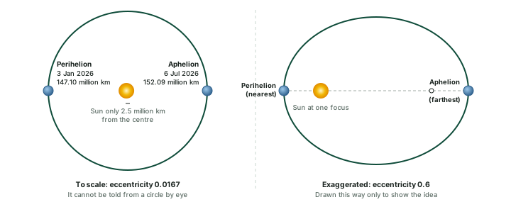
The point of the orbit nearest the Sun is perihelion and the farthest is aphelion. In 2026 the Earth passed perihelion on 3 January and aphelion on 6 July (table below). The two distances differ by about 5 million km, which is only about 3% of the average distance (computed).
Perihelion and aphelion, 2026
| Perihelion (nearest) | Aphelion (farthest) | |
|---|---|---|
| Date and time (UT) | 3 Jan 2026, 17:16 | 6 Jul 2026, 17:31 |
| Date and time (IST) | 3 Jan 2026, 22:46 | 6 Jul 2026, 23:01 |
| Distance from the Sun in 2026 | 147.10 million km | 152.09 million km |
| Average value (NASA) | 147.095 million km | 152.100 million km |
| Orbital speed (NASA) | 30.29 km/s, the fastest | 29.29 km/s, the slowest |
| Season in north India (NCERT) | Cold weather season | Southwest monsoon season |
2026 instants and distances: F. Espenak, Earth at perihelion and aphelion, 2001 to 2100. Average distances and speeds: NASA Earth Fact Sheet (updated 15 Nov 2024). Seasons: NCERT, India: Physical Environment, Class XI, ch. 4 "Climate" (Reprint 2026-27). IST = UT + 5 h 30 min (computed).
Worked example: How much stronger is sunlight at perihelion?
Sunlight spreads out over a larger area as distance grows, so its strength falls with the square of the distance. Compare the 2026 perihelion (147.10 million km) with the aphelion (152.09 million km).
- Ratio of distances: 152.09 ÷ 147.10 = 1.0339.
- Square it: 1.0339² = 1.069.
Answer: about 7% more sunlight reaches the Earth at perihelion than at aphelion (computed). Yet NCERT counts December and January as the coldest months in the northern plain, so distance cannot be what makes the seasons. The tilt of the axis does that (see the section on Seasons, Insolation and Heat Zones).
Faster when nearer: Kepler's second law
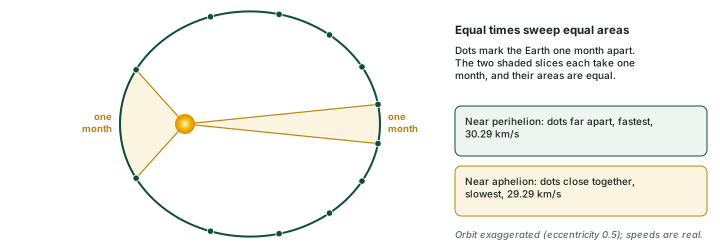
The Earth does not move at a steady speed. NASA gives Kepler's second law as: "the imaginary line joining a planet and the Sun sweeps equal areas of space during equal time intervals as the planet orbits." Near the Sun the line is short, so the Earth must cover a longer stretch of orbit to sweep the same area; far from the Sun the line is long and a shorter stretch does it (diagram below). The Earth's speed ranges from 30.29 km/s at its fastest to 29.29 km/s at its slowest, with an average of 29.78 km/s (NASA Earth Fact Sheet (updated 15 Nov 2024)).
The changing speed shows up on the calendar. In 2026 the March equinox fell on 20 March at 14:46 UT and the September equinox on 23 September at 00:06 UT (F. Espenak, Solstices and equinoxes, 2001 to 2100). From one to the other is 186.4 days, so the other half of the year, from September back to March, lasts only about 178.9 days (computed, with a tropical year of 365.242 days). The Northern Hemisphere's summer half-year is about a week longer because aphelion falls inside it, when the Earth moves slowest.
Don't confuse: Perihelion and the solstice
Perihelion (early January; 3 January in 2026) comes about two weeks after the December solstice (about 21 December), but they are different events. Perihelion is about distance: the Earth is nearest the Sun. The solstice is about the tilt: the Sun is overhead at its farthest south, on the Tropic of Capricorn. In the same way, aphelion (6 July) is not the June solstice (21 June).
The year and the leap year
NCERT's Class VI book says the Earth "takes 365¼ days (one year) to revolve around the sun." A calendar has to count whole days, so the book explains: "We consider a year as consisting of 365 days only and ignore six hours for the sake of convenience. Six hours saved every year are added to make one day (24 hours) over a span of four years." That day goes into February, which then has 29 days: "Such a year with 366 days is called a leap year".
The year that the calendar follows is the tropical year. NASA defines it as the time for the Earth "to orbit the Sun from one vernal equinox to the next" and gives it as 365.242 days, about 365 days 5 hours 48 minutes (computed). The Hong Kong Observatory gives 365.2422 days. That is a little less than 365¼, so adding a day every four years over-corrects. The Observatory notes that the mean Julian calendar year "exceeds the length of the tropical year (365.2422 days) by about 11 m 14s." Those minutes add up to a whole day in about 128 years (computed).
The fix came in 1582, when, in the Observatory's words, "Pope Gregory XIII revised the Julian calendar and adopted a different rule for leap year by omitting the intercalary day in century years that are not divisible by 400." This is the Gregorian calendar used today. Its rule has three steps (diagram below).
Worked example: Is 2100 a leap year?
Apply the Gregorian rule to the year 2100.
- 2100 ÷ 4 = 525, so it passes the first test.
- 2100 is a century year (2100 ÷ 100 = 21), so it must also divide by 400.
- 2100 ÷ 400 = 5.25, not a whole number.
Answer: No. 2100 will have 365 days, and February 2100 will have 28 days.
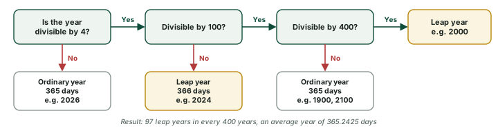
With 97 leap days in 400 years, the average Gregorian year is 365 + 97 ÷ 400 = 365.2425 days, which the Observatory calls "quite close to the length of the tropical year of 365.2422 days." The gap left is about 26 seconds a year (computed).
Don't confuse: Sidereal year and tropical year
- Sidereal year (365.256 days): one orbit measured against the stars.
- Tropical year (365.242 days): from one March equinox to the next. It keeps the seasons on the same dates, so the calendar follows it.
The two differ by about 20 minutes (computed from the NASA Earth Fact Sheet (updated 15 Nov 2024)).
Rotation and revolution compared
| Rotation | Revolution | |
|---|---|---|
| What moves | The Earth spins on its axis, from west to east | The Earth travels round the Sun in its orbit |
| Time taken | 23 h 56 min 4 s against the stars; 24 h from noon to noon | 365.256 days against the stars; 365.242 days from equinox to equinox |
| Speed | Up to about 1,674 km/h at the equator, zero at the poles (computed) | 29.78 km/s on average, about 107,000 km/h (computed from NASA) |
| Main results | Day and night; the Coriolis effect; the difference in time between places | The year and leap years; together with the tilted axis, the seasons and changing length of day (see the section on Seasons, Insolation and Heat Zones) |
NCERT, The Earth: Our Habitat, Class VI, ch. 3 "Motions of the Earth" (rationalised edition 2023-24); NASA Earth Fact Sheet (updated 15 Nov 2024); NASA, Planetary Fact Sheet notes (updated 20 Dec 2021). Rotation speed computed in section 3.4.
Rotation and revolution in five lines
- Rotation: 23 h 56 min 4 s against the stars, 24 h against the Sun; west to east.
- Ground speed: about 1,674 km/h at the equator, falling with the cosine of latitude.
- Coriolis effect: winds and currents turn right in the north, left in the south; zero at the equator.
- Orbit: an ellipse of eccentricity 0.0167; perihelion 3 Jan 2026, aphelion 6 Jul 2026.
- Year: 365.242 days (tropical); the Gregorian calendar averages 365.2425 days.
Seasons, Insolation and Heat Zones
The Earth's tilted axis, carried round the Sun with its direction fixed, is what gives the year its seasons. This section follows the tilt through one orbit: where the noon Sun stands overhead in each month of 2026, why slanting sunlight warms the ground less, why days are long in summer and short in winter, and how the same geometry divides the globe into heat zones. It ends with the Zero Shadow Day that places in the tropics, including much of India, see twice a year.
The tilted axis
The Earth's axis is not upright to the plane of its orbit. It leans by 23.44° from the perpendicular (NASA Earth Fact Sheet (updated 15 Nov 2024)). Measured from the plane of the orbit itself, the angle is 90° − 23.44° = 66.56° (computed). NCERT's Class VI book gives the rounded value: "The axis of the earth which is an imaginary line, makes an angle of 66½° with its orbital plane." The tilt is not fixed for ever: NASA notes that it varies between 22.1° and 24.5° over a cycle that averages about 40,000 years (NASA Earth Observatory, "Milutin Milankovitch").
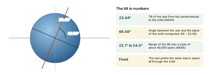
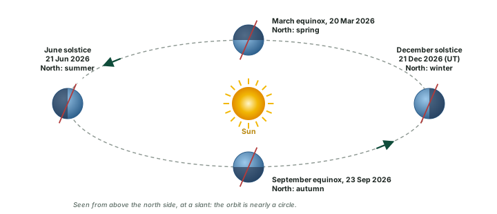
Two facts about the tilt make the seasons. First, its size: 23.44° sets how far north and south of the Equator the Sun can be overhead, and how far from the poles the zone of round-the-clock daylight and darkness reaches. Second, its direction stays the same all through the orbit. In NCERT's words: "Notice that throughout its orbit, the earth is inclined in the same direction." So for half the year the North Pole leans towards the Sun, and for the other half it leans away.
Where the tropics and polar circles come from
The important latitudes all come from the tilt. The Tropics lie at 23.44° (about 23°26′) north and south: the farthest the overhead Sun goes. The Arctic and Antarctic Circles lie at 90° − 23.44° = 66°34′ (computed): the edge of the zone that gets at least one day of 24-hour sunlight and one of 24-hour night. NCERT rounds these to 23½° and 66½°.
Four positions in the orbit
NCERT puts the cause in one line: "Seasons change due to the change in the position of the earth around the sun." Because the axis keeps its direction, the hemisphere that leans towards the Sun changes as the Earth moves round. Four points in the orbit mark the turning points (diagram below):
- June solstice: the North Pole leans towards the Sun. The Northern Hemisphere has summer and its longest day.
- December solstice: the South Pole leans towards the Sun. The Southern Hemisphere has summer; the north has winter.
- March and September equinoxes: neither pole leans towards the Sun, and day and night are nearly equal everywhere.
Equinoxes and solstices, 2026
| Event | Time (UT) | Time (IST) | Sun overhead at noon |
|---|---|---|---|
| March equinox | 20 Mar, 14:46 | 20 Mar, 20:16 | Equator |
| June solstice | 21 Jun, 08:25 | 21 Jun, 13:55 | Tropic of Cancer |
| September equinox | 23 Sep, 00:06 | 23 Sep, 05:36 | Equator |
| December solstice | 21 Dec, 20:50 | 22 Dec, 02:20 | Tropic of Capricorn |
Instants: F. Espenak, Solstices and equinoxes, 2001 to 2100. IST = UT + 5 h 30 min (computed).
The textbook dates (21 March, 21 June, 23 September, 22 December in NCERT) are round values. The exact instant falls at a different hour each year, which is why the December solstice of 2026 is on 21 December by Universal Time but already 22 December in India.
Why the tilt, not the distance
The distance to the Sun does change through the year, but it is not what makes the seasons. NASA Space Place puts it plainly: "Earth's tilted axis causes the seasons." It adds: "Earth's distance from the Sun is not the cause of the seasons." The proof is in the calendar: the Earth is nearest the Sun in early January, in the middle of the northern winter (NASA Space Place, "What causes the seasons?" (updated 29 Jul 2025)).
The solstices and equinoxes up close
A side view shows what changes at each turning point (diagram below). The Sun's rays arrive parallel. Where they strike the ground at right angles, the noon Sun is overhead (the red dot). The circle of illumination always cuts the globe into a day half and a night half, but the tilt decides where the parallels of latitude sit against it.
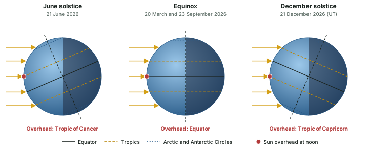
NCERT describes the June position: "on 21st June, the Northern Hemisphere is tilted towards the sun. The rays of the sun fall directly on the Tropic of Cancer." The longest day and shortest night in the north come then, and "This position of the earth is called the Summer Solstice." On the December solstice the Tropic of Capricorn gets the direct rays and the Southern Hemisphere has its summer; NCERT adds: "Do you know that Christmas is celebrated in Australia in the summer season?" At the equinoxes "the whole earth experiences equal days and equal nights. This is called an equinox."
Don't confuse: Summer solstice for whom?
"Summer solstice" and "winter solstice" are names from the Northern Hemisphere. The June solstice brings summer to the north but winter to the south, so the neutral names June solstice and December solstice avoid confusion. In the same way, the March equinox opens spring in the north and autumn in the south.
The overhead Sun moves north and south
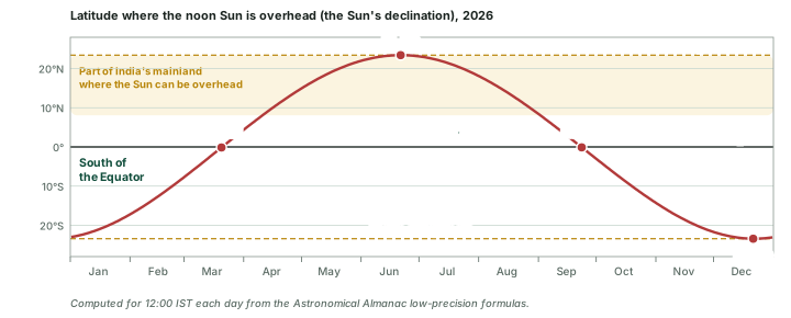
On any date there is one latitude where the noon Sun stands straight overhead. Astronomers call it the Sun's declination. The diagram below follows it through 2026, computed for every day of the year. It climbs from the Tropic of Capricorn in December, crosses the Equator at the March equinox, reaches the Tropic of Cancer at the June solstice and turns back.
Three things stand out from the curve.
- The overhead Sun never leaves the tropics. It reaches 23°26′ N and 23°26′ S (from the tilt of 23.44°) and no further. Places beyond the tropics never have the Sun overhead.
- It moves unevenly. Near the equinoxes it shifts about 0.4° of latitude a day (computed, roughly 44 km a day). Near the solstices it almost halts: on 21 June 2026 it moves only 0.003° (computed). So for several days around each solstice the noon Sun keeps almost the same height.
- The two halves are unequal. From the March to the September equinox of 2026 the overhead Sun stays north of the Equator for 186.4 days; it is south for the remaining 178.9 days (computed). The Earth moves more slowly near aphelion in July, so the northern summer half-year is longer (see the section on Rotation and Revolution).
One number for each date
The latitude of the overhead noon Sun is 0° at both equinoxes, 23°26′ N at the June solstice and 23°26′ S at the December solstice. Every question about the noon Sun's height, the length of day or the Zero Shadow Day starts from this one number for the date.
Insolation and the angle of the Sun's rays
NCERT's Class XI book defines the term: "The energy received by the earth is known as incoming solar radiation which in short is termed as insolation." At the top of the atmosphere the Earth receives, on average, "1.94 calories per sq. cm per minute" (NCERT), which is about 1,350 watts per square metre (computed).
How much of it reaches a given place depends, in NCERT's list, on five factors:
- the rotation of the Earth on its axis (day and night);
- the angle of inclination of the Sun's rays;
- the length of the day;
- the transparency of the atmosphere;
- the configuration of land in terms of its aspect (which way a slope faces).
NCERT adds that "The last two however, have less influence." The first three are set by the Earth's motions and its tilt, and they are the subject of the rest of this part.
Why slanting rays heat less
NCERT gives two reasons. The first is spreading: "The area covered by vertical rays is always less than the slant rays. If more area is covered, the energy gets distributed and the net energy received per unit area decreases." The second is the air: "the slant rays are required to pass through greater depth of the atmosphere resulting in more absorption, scattering and diffusion." The Class VI book makes the same point with a torch: light falling straight down "is bright and covers a smaller area"; on a slanted surface it "is less bright but covers a bigger area."
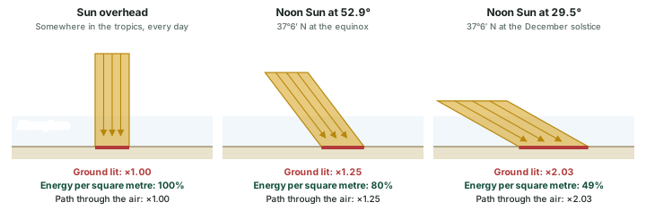
Height of the noon Sun across India, 2026
| Date | Sun overhead at | 8°4′ N (southern limit) | 23°26′ N (Tropic of Cancer) | 37°6′ N (northern limit) |
|---|---|---|---|---|
| June solstice | 23°26′ N | 74.6° (N) | 90° (overhead) | 76.3° (S) |
| Equinoxes | 0° | 81.9° (S) | 66.6° (S) | 52.9° (S) |
| December solstice | 23°26′ S | 58.5° (S) | 43.1° (S) | 29.5° (S) |
Computed: altitude = 90° − |latitude − declination|. (N) or (S): the noon Sun is to the north or south of overhead. Latitudes: NCERT, Contemporary India I, Class IX, ch. 1 (Reprint 2025-26).
Two lessons sit in the table. The noon Sun at India's northern limit is nearly 47° lower in December than in June (computed): slanting rays and shorter days, two of NCERT's factors, act together in the northern winter. And in June the noon Sun stands to the north of overhead for every place south of the Tropic of Cancer, so at noon a vertical pole at India's southern tip casts its short shadow towards the south.
Worked example: Noon Sun at India's northern limit in December
At the December solstice of 2026 the Sun is overhead at 23°26′ S. How high is the noon Sun at 37°6′ N, and how strong is the sunlight on level ground compared with an overhead Sun?
- Angular distance between the place and the overhead point: 37.1° + 23.44° = 60.5°.
- Noon altitude = 90° − 60.5° = 29.5°.
- Energy per square metre compared with an overhead Sun = sin 29.5° = 0.49.
Answer: The noon Sun stands 29.5° high, and level ground gets only about 49% of the energy an overhead Sun would give it (computed, before any loss in the air).
Don't confuse: Distance versus angle
The Earth is nearest the Sun on 3 January 2026 and farthest on 6 July 2026, and sunlight at the top of the atmosphere is about 7% stronger at perihelion (computed in the section on Rotation and Revolution). NCERT notes that "the effect of this variation in the solar output is masked by other factors like the distribution of land and sea and the atmospheric circulation." The angle of the rays and the length of the day matter far more.
Length of day and the midnight Sun
The tilt also decides how long the Sun stays above the horizon. In June the circle of illumination reaches beyond the North Pole (as in the side view of sunlight above), so every parallel in the Northern Hemisphere has more than half its length in daylight: days are longer than nights, and more so the farther north a place is. In December the same parallels are mostly in darkness. The Equator is always cut exactly in half, so its day is about 12 hours all year round (diagram below).
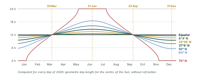
Do the numbers: Working out the length of day
For a place at latitude φ on a date when the overhead Sun is at δ, the Sun rises and sets at an hour angle H given by cos H = − tan φ × tan δ. The day lasts 2H ÷ 15 hours, because the Earth turns 15° an hour. When tan φ × tan δ reaches 1 the Sun does not set at all; when it reaches −1 it does not rise.
Worked example: Longest day at India's northern limit
How long is the day at 37°6′ N at the June solstice of 2026, when the Sun is overhead at 23.44° N?
- tan 37.1° × tan 23.44° = 0.7563 × 0.4336 = 0.3279.
- cos H = −0.3279, so H = 109.14°.
- Day length = 2 × 109.14 ÷ 15 = 14.55 hours.
Answer: About 14 h 33 min of daylight, against 9 h 27 min at the December solstice (both computed). At India's southern limit (8°4′ N) the same two days give 12 h 28 min and 11 h 32 min.
Length of day at the solstices and equinoxes
| Latitude | June solstice | Equinoxes | December solstice |
|---|---|---|---|
| Equator | 12 h 00 min | 12 h 00 min | 12 h 00 min |
| 8°4′ N | 12 h 28 min | 12 h 00 min | 11 h 32 min |
| 23°26′ N | 13 h 27 min | 12 h 00 min | 10 h 33 min |
| 37°6′ N | 14 h 33 min | 12 h 00 min | 9 h 27 min |
| 50° N | 16 h 09 min | 12 h 00 min | 7 h 51 min |
| 60° N | 18 h 29 min | 12 h 00 min | 5 h 31 min |
| 66°34′ N | 24 h 00 min | 12 h 00 min | 0 h 00 min |
| 70° N | 24 h 00 min | 12 h 00 min | 0 h 00 min |
| 80° N | 24 h 00 min | 12 h 00 min | 0 h 00 min |
| North Pole | 24 h 00 min | Sun on the horizon all day | 0 h 00 min |
Computed (geometric, centre of the Sun, no refraction) with δ = +23.44°, 0° and −23.44°. Real day lengths are a few minutes longer: Royal Observatory of Belgium, "Why does the day of the equinox have (slightly) more than 12 hours of daylight?". In the Southern Hemisphere the June and December columns swap.
The figures are geometric, for the centre of the Sun. The Royal Observatory of Belgium explains why real days are a little longer: "Sunrise (sunset) is defined as the time when the upper edge of the solar disc, not the centre of the Sun, appears (disappears) on the horizon," and the atmosphere bends sunlight so that "the upper edge of the Sun may be visible when it is actually below the horizon." Together, it says, "These two effects combined therefore explain why the length of the day is longer than 12 hours on the day of the equinox."
The midnight Sun and the polar night
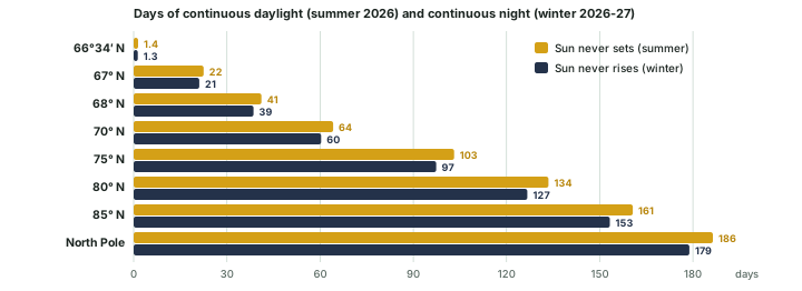
North of the Arctic Circle the Sun stays up through the night for part of the summer and stays below the horizon for part of the winter. How long depends on the latitude (diagram below). At the Circle itself it is only about a day; at 70° N the Sun does not set for about 64 days; at the North Pole it stays up for 186 days, from the March to the September equinox, and then stays down for about 179 (all computed for 2026-27). About six months of day followed by about six months of night happens only at the poles themselves.
Heat zones
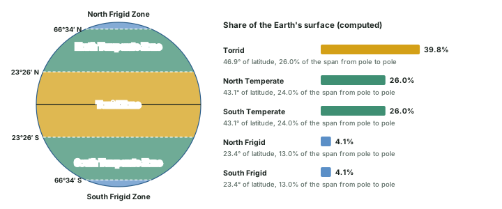
The tropics and the polar circles split the globe into five heat zones, defined by how high the Sun can climb (diagram above). NCERT's Class VI book describes them:
- Torrid Zone (between the tropics): "The mid-day sun is exactly overhead at least once a year on all latitudes in between the Tropic of Cancer and the Tropic of Capricorn. This area, therefore, receives the maximum heat and is called the Torrid Zone."
- Temperate Zones (from each tropic to its polar circle): the noon Sun is never overhead, and these areas "have moderate temperatures. These are, therefore, called Temperate Zones."
- Frigid Zones (from each polar circle to its pole): "It is because here the sun does not rise much above the horizon. Therefore, its rays are always slanting and provide less heat. These are, therefore, called Frigid Zones (very cold)."
The five heat zones
| Zone | Latitudes | Share of the surface | The noon Sun |
|---|---|---|---|
| Torrid Zone | 23°26′ S to 23°26′ N | 39.8% | Overhead at noon once or twice a year |
| North Temperate Zone | 23°26′ N to 66°34′ N | 26.0% | Never overhead; rises and sets every day |
| South Temperate Zone | 66°34′ S to 23°26′ S | 26.0% | Never overhead; rises and sets every day |
| North Frigid Zone | 66°34′ N to Pole | 4.1% | Never overhead; stays up for a day or more in summer and down in winter |
| South Frigid Zone | Pole to 66°34′ S | 4.1% | Never overhead; stays up for a day or more in summer and down in winter |
Definitions: NCERT, The Earth: Our Habitat, Class VI, ch. 2 "Globe: Latitudes and Longitudes" (rationalised edition 2023-24). Shares computed for a sphere. "Once or twice a year": twice between the tropics, once on each tropic (computed from the curve of the overhead noon Sun above).
NCERT's Class IX book notes that the Tropic of Cancer "divides the country into almost two equal parts". So by this geometric scheme the southern half of India lies in the Torrid Zone and the northern half in the North Temperate Zone.
Don't confuse: Torrid Zone versus the sunniest places
The Torrid Zone is where the Sun can be overhead, but the Equator is not where the ground gets the most sunlight. NCERT's Class XI book: "Maximum insolation is received over the subtropical deserts, where the cloudiness is the least. Equator receives comparatively less insolation than the tropics." It adds that insolation at the surface "varies from about 320 Watt/m² in the tropics to about 70 Watt/m² in the poles." Cloud cover, not just the angle of the Sun, decides how much reaches the ground.
Zero Shadow Day
When the noon Sun is exactly overhead, an upright pole casts no shadow at all. The outreach page of the Astronomical Society of India explains that "it happens twice a year, for places between +23.5 and -23.5 degrees latitude." For Bengaluru it lists 24 April and 18 August (Astronomical Society of India, "Zero Shadow Day").
The dates follow straight from the curve of the overhead noon Sun above. A place in the tropics gets its Zero Shadow Day when the overhead Sun passes its latitude: once on the way north and once on the way back. On Bengaluru's two dates the overhead Sun is at 12.9° N and 13.1° N (computed for 2026), which places the city near 13° N. A place exactly on a tropic gets only one Zero Shadow Day, at the solstice. In the northern half of India, north of the Tropic of Cancer, there is none.
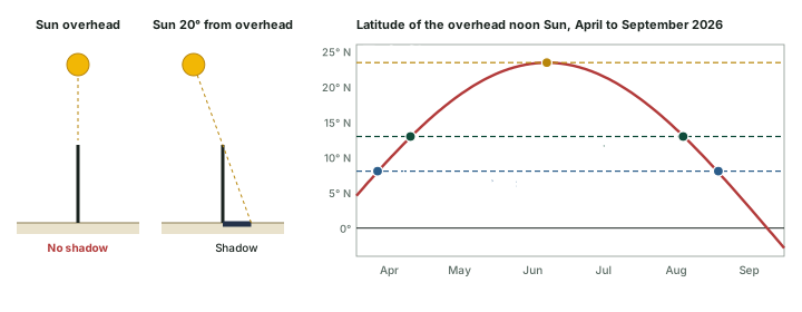
Two more results come out of the curve. The noon Sun is overhead somewhere on India's mainland from about 10 Apr to 2 Sep 2026, for 144 days (computed). And the shadow vanishes only at local noon, the moment the Sun crosses the meridian of the place, which in India falls at different clock times from east to west (see the section on Longitude and Time).
Worked example: Shadows on Bengaluru's Zero Shadow Day
On 24 April 2026 the noon Sun is overhead at 12.89° N (computed). How long is the noon shadow of a 1 m upright stick at 8°4′ N and at the Tropic of Cancer, and which way does it point?
- At 8°4′ N the Sun is 12.89° − 8.07° = 4.82° from overhead, on the north side. Shadow = tan 4.82° = 0.084 m, pointing south.
- At 23°26′ N the Sun is 23.44° − 12.89° = 10.55° from overhead, on the south side. Shadow = tan 10.55° = 0.186 m, pointing north.
Answer: About 8 cm pointing south at the southern limit, and about 19 cm pointing north at the Tropic (computed).
Seasons in five lines
- The 23.44° tilt (66.56° to the orbit plane), fixed in direction, makes the seasons, not distance.
- 2026: equinoxes 20 Mar and 23 Sep; solstices 21 Jun and 21 Dec (22 Dec in IST).
- Slant rays spread wider and cross more air; noon altitude = 90° − |latitude − declination|.
- Day length grows with latitude in summer; continuous daylight lasts from about one day at 66°34′ to about six months at the Pole.
- Five heat zones, Torrid about 40% of the surface; Zero Shadow Day: Bengaluru 24 Apr and 18 Aug.
Sources
Each table and data figure names its source beneath it. The main documents are collected here, with a date where the source carries one. Figures not listed under image credits were drawn for this page from the data and formulas stated in their source lines.
Main sources
| Topic | Source |
|---|---|
| Planets, the Sun and the Earth | NASA Planetary Fact Sheet (18 Mar 2025); NASA Earth Fact Sheet; NASA, Earth facts; NASA, Sun facts |
| Orbit, tilt, seasons | F. Espenak, perihelion and aphelion 2001-2100; F. Espenak, equinoxes and solstices 2001-2100; NASA Earth Observatory, Milankovitch |
| India: extent, time, Zero Shadow Day | NCERT Class IX, Contemporary India I, ch. 1 (reprint 2025-26); NCERT Class XI, India: Physical Environment, ch. 1 (reprint 2026-27); CSIR-NPL, Indian Standard Time; Astronomical Society of India, Zero Shadow Day |
Image credits
| Image | Credit and licence |
|---|---|
| World land outlines on maps | Natural Earth, 1:110m physical vectors. Public domain. |
| All other figures | Drawn for this page from the data and formulas given in their source lines. |