 BharatNotes
Part 1 of 6 of the Astronomical Geography notes. The overview page has the quick revision, exam strategy and key terms for all six parts.
Origin of the Solar System and Earth
This section starts at the beginning, with the birth of the Sun and planets about 4.6 billion years ago, and ends with the geological time scale that geographers use to date landforms.
The nebular hypothesis
The accepted scientific account of how the solar system formed is the nebular hypothesis. The idea goes back to the philosopher Immanuel Kant and the mathematician Pierre-Simon Laplace in the second half of the 18th century. Its modern form, often called the Solar Nebular Disk Model, adds 20th-century work on how solid bodies grow by accretion, and today it is tested against telescope images of young stars that are still surrounded by flat disks of gas and dust.
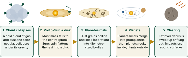
The story runs in five steps (diagram above). A cold cloud of gas and dust, the solar nebula, began to collapse under its own gravity. As it fell inward it spun faster, just as a skater spins faster when the arms are pulled in. Most of the mass gathered at the centre and became the proto-Sun; the rest flattened into a rotating protoplanetary disk. Inside the disk, dust grains collided and stuck together, growing into kilometre-sized planetesimals. These merged into protoplanets and finally into planets, and the leftover debris was swept up or scattered.
Two outcomes of this process explain a great deal. First, the Sun holds about 99.8% of the solar system's mass (NASA), because most of the nebula fell to the centre. Second, all the planets orbit the Sun in the same direction and in nearly the same plane, because they formed from one spinning, flattened disk.
Why rocky planets inside, giants outside
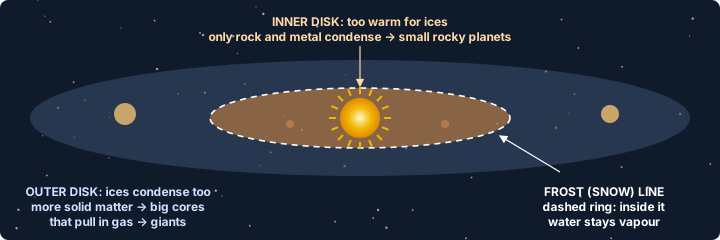
Temperature in the disk fell with distance from the young Sun. Close in, it was too warm for water and other ices to freeze, so only rock and metal could condense: this gave small, dense, terrestrial planets (Mercury, Venus, Earth, Mars). Farther out, beyond the so-called frost line, ices froze as well. In the standard model, with far more solid material to build from, protoplanets there grew large enough to pull in hydrogen and helium gas from the disk, becoming the gas giants (Jupiter, Saturn) and the ice giants (Uranus, Neptune).
Two ideas that are still hypotheses
What triggered the collapse? One old idea is that a shock wave from a nearby exploding star (supernova) set the cloud collapsing. It is contested: measurements of short-lived isotopes in meteorites give mixed support. Write "one hypothesis", never "was triggered by".
Late Heavy Bombardment. A spike of impacts on the inner planets about 4.1 to 3.8 billion years ago was long inferred from Moon rocks. Whether it was a sharp spike or the tail of a slowly declining impact rate is still debated.
Earth forms and layers itself
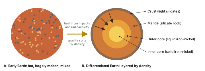
Earth is about 4.54 billion years old, a figure from radiometric dating of meteorites and the oldest materials, with an uncertainty of less than 1% (USGS). The young planet was heated by the energy of colliding planetesimals and by radioactive decay, and much of it melted. In a molten body, gravity sorts material by density: heavy iron and nickel sank to the centre to form the core, while lighter silicate rock rose to form the mantle and, at the top, the crust. This sorting is called planetary differentiation, and it is why Earth has layers.
The origin of the Moon
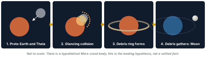
The leading explanation is the giant-impact hypothesis. A Mars-sized protoplanet, named Theia, struck the young Earth a glancing blow. The impact threw out a ring of hot debris, mostly from the outer layers of both bodies, which gathered into the Moon. The model explains why the Moon is poor in iron (it formed largely from mantle-like rock); why its rocks are so similar to Earth's is still debated. Estimates of when it happened vary; "about 4.5 billion years ago" is a fair summary.
The first oceans and the first life
As the surface cooled, water vapour released by volcanoes (outgassing), probably with some water delivered by comets and asteroids, condensed into the first oceans. The evidence is indirect, so the milestones below are best read as current estimates rather than fixed facts.
Early-Earth milestones: estimates, not settled facts
- Oldest mineral grains: zircon crystals from the Jack Hills of Western Australia are about 4.4 billion years old. Their chemistry suggests that continental crust and liquid water existed very early, but that is an inference, still debated.
- Earliest life: layered microbial mounds called stromatolites in the Dresser Formation of the Pilbara, Western Australia, about 3.48 billion years old, are among the oldest widely accepted signs of life. Older claims, such as about 3.7 billion years at Isua in Greenland, are disputed.
- Oxygen: the Great Oxidation Event, when free oxygen first built up in the air, began about 2.4 billion years ago and was a drawn-out process (roughly 2.5 to 2.3 billion years ago), not a single moment.
The solar system in numbers
The eight planets
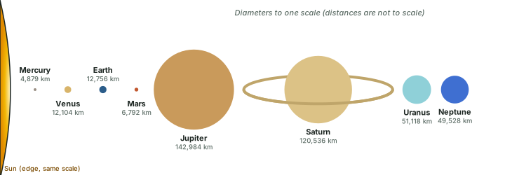
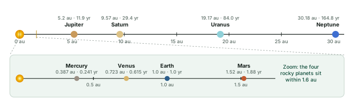
| Planet | Mean distance from Sun (au) | Equatorial diameter (km) | Mass (Earth = 1) | Orbital period (years, sidereal) | Known moons |
|---|---|---|---|---|---|
| Mercury | 0.387 | 4,879 | 0.055 | 0.241 | 0 |
| Venus | 0.723 | 12,104 | 0.815 | 0.615 | 0 |
| Earth | 1.0 | 12,756 | 1.0 | 1.0 | 1 |
| Mars | 1.52 | 6,792 | 0.107 | 1.88 | 2 (Phobos, Deimos) |
| Jupiter | 5.2 | 142,984 | 317.8 | 11.9 | 115 (NASA, Sep 2026)* |
| Saturn | 9.57 | 120,536 | 95.2 | 29.4 | 293 (NASA, Aug 2026) |
| Uranus | 19.17 | 51,118 | 14.5 | 84.0 | 29 (NASA, Aug 2026) |
| Neptune | 30.18 | 49,528 | 17.1 | 164.8 | 16 (NASA) |
Distance, diameter and mass: NASA Planetary Fact Sheet (updated 18 Mar 2025); distances are NASA's values in astronomical units (1 au = Earth's mean distance, about 149.6 million km). Period: the sidereal orbit period (one orbit relative to the stars) from NASA's individual planet fact sheets, in years of 365.25 days (computed); the summary sheet's "orbital period" is the tropical period, equinox to equinox, which is slightly shorter (Neptune 163.7 years). Moons: NASA planet pages (Sep-Oct 2026). *NASA says Jupiter's 115 moons are recognised by the IAU; the IAU Minor Planet Center announcement of 26 Mar 2026 had given a total of 101. Counts change as new moons are confirmed, so quote the source and date.
Uranus gained its 29th known moon, S/2025 U1, found with the James Webb Space Telescope and announced on 19 August 2025 (NASA Webb blog, 19 Aug 2025; count: NASA, Uranus moons).
Two families of planets
- Terrestrial (inner) planets: Mercury, Venus, Earth, Mars. Small, rocky, dense, with few or no moons.
- Gas giants: Jupiter, Saturn. Ice giants: Uranus, Neptune. Large, low density, many moons and ring systems.
- The asteroid belt lies between Mars and Jupiter.
Dwarf planets
The IAU reclassified Pluto as a dwarf planet in 2006. NASA lists five dwarf planets: Ceres, Pluto, Haumea, Makemake and Eris. Ceres is the only one in the inner solar system (in the asteroid belt); the others lie beyond Neptune.
The geological time scale
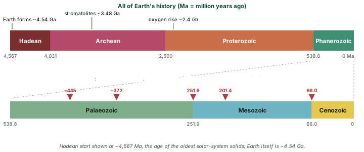
To talk about Earth's 4.54-billion-year history, geologists divide it into nested units: eons are split into eras, eras into periods, and periods into epochs. The official boundaries are set by the International Commission on Stratigraphy (ICS) and are revised as dating improves. The figures below are from the ICS chart, version 2024/12.
Eons and eras (Ma = million years ago)
| Eon | Era | Span (Ma) | Key events |
|---|---|---|---|
| Hadean | — | ~4,567 to 4,031 | Molten surface; differentiation; Moon-forming impact (hypothesis) |
| Archean | — | 4,031 to 2,500 | Early continents; earliest widely accepted life (stromatolites, ~3,480) |
| Proterozoic | — | 2,500 to 538.8 | Great Oxidation Event (~2,400); first complex (eukaryotic) cells; first multicellular life |
| Phanerozoic | Palaeozoic | 538.8 to 251.9 | "Cambrian explosion" of animal life; fish, land plants, amphibians, reptiles; ends with the end-Permian extinction |
| Mesozoic | 251.9 to 66.0 | "Age of reptiles": dinosaurs; first mammals and birds; flowering plants; the supercontinent Pangaea breaks up | |
| Cenozoic | 66.0 to today | "Age of mammals"; India collides with Asia and the Himalaya rise; Quaternary ice ages; Holocene (last 11,700 years) |
Boundaries: ICS International Chronostratigraphic Chart v2024/12. Events: standard summaries; dates of early-life events are estimates (see the hypothesis box above).
The "Big Five" mass extinctions
| Extinction | Age (Ma) | Notes |
|---|---|---|
| Late Ordovician | ~445 | Ice age and falling sea level |
| Late Devonian | ~372 | A series of pulses; marine life worst hit |
| End-Permian ("the Great Dying") | 251.9 | Largest of all: about 81% of marine species lost (Stanley 2016); older estimates said 90-96%. Linked to Siberian Traps volcanism |
| End-Triassic | 201.4 | Linked to huge volcanic outpourings as Pangaea began to split; dinosaurs then dominated the Jurassic |
| End-Cretaceous (K-Pg) | 66.0 | Chicxulub asteroid impact (main cause), with Deccan Traps volcanism in India a possible contributor; ended the non-avian dinosaurs |
Ages: boundary ages on the ICS International Chronostratigraphic Chart v2024/12 (Hirnantian, Frasnian-Famennian, Permian-Triassic, Triassic-Jurassic, Cretaceous-Palaeogene). End-Permian loss: S. M. Stanley, PNAS 113 (2016), "Estimates of the magnitudes of major marine mass extinctions in Earth history".
Our address in geological time
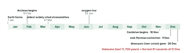
We live in the Holocene Epoch of the Quaternary Period of the Cenozoic Era of the Phanerozoic Eon. The Holocene began 11,700 years ago. A proposed new epoch, the Anthropocene, was rejected as a formal unit in March 2024 (vote of the ICS Subcommission on Quaternary Stratigraphy, upheld by the IUGS); the word is still used informally.
Shape and Size of the Earth
Ask anyone what shape the Earth is and the answer is "round". This section shows how we know that from things anyone can see, then sharpens the answer: the Earth is very slightly flattened at the poles and bulges at the equator, and its true sea-level shape, the geoid, is lumpier still. It ends with the numbers to carry into the exam: radii, circumference, surface area and the share of the surface covered by ocean.
How we know the Earth is round
Long before anyone saw the Earth from space, people worked out its shape from what they could see around them. Each clue below could, on its own, have some other explanation. Taken together they leave only one: the Earth is a ball.
Ships sink hull first over the horizon
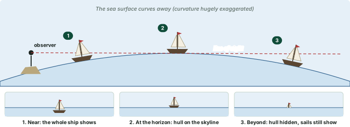
Watch a ship sail out to sea on a clear day. It does not simply shrink to a dot. First the hull disappears, then the lower sails, and the top of the mast goes last. On a flat sea the whole ship would shrink evenly. On a curved sea, the bulge of water between you and the ship rises into your line of sight and hides the lower parts first (diagram below). A ship coming towards you shows the reverse: mast first, hull last.
The higher you stand, the farther you see
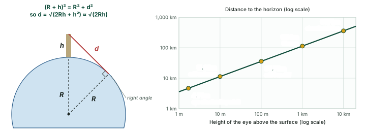
The horizon is where your line of sight just touches the curved surface. Climb higher and that point moves farther away, which is why lookouts were posted at the top of a mast and lighthouses are built tall. The distance follows from Pythagoras' theorem: if R is the Earth's radius and h the height of your eye, the distance d to the horizon satisfies (R + h)² = R² + d². Since h is tiny compared with R, d ≈ √(2Rh)**.
Distance to the horizon
| Viewpoint | Eye height | Horizon distance |
|---|---|---|
| Eye of a standing adult on a beach | 1.7 m | 4.7 km |
| Top of a 10 m tower | 10 m | 11.3 km |
| A 30 m lighthouse | 30 m | 19.6 km |
| A 100 m cliff | 100 m | 35.7 km |
| A hill or balloon 1 km up | 1,000 m | 113 km |
| An aircraft at 10 km | 10,000 m | 357 km |
Computed: d = √(2Rh), R = 6,371.0 km; no allowance for atmospheric refraction.
Worked example: the horizon from a beach
How far away is the sea horizon for a person whose eyes are 1.7 m above the water?
- Convert to the same unit: h = 1.7 m = 0.0017 km; R = 6,371 km.
- d = √(2 × 6,371 × 0.0017) = √21.66.
- Note how slowly d grows: four times the height gives only twice the distance, because d grows with √h.
Answer: about 4.7 km. A ship 20 km out is already "over the horizon" for this person, though its masts may still show.
Earth's shadow on the Moon is always round
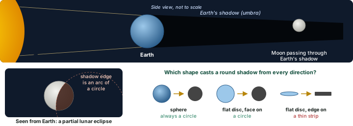
In a lunar eclipse the Moon passes through the shadow that the Earth casts away from the Sun (see the section on Eclipses). The edge of that shadow, creeping across the Moon, is always an arc of a circle. Eclipses happen with the Moon high or low in the sky and at every season, so the Earth is lit from many different directions, yet the shadow is round every time. A flat disc would cast a round shadow only when it faced the Sun squarely; turned edge-on it would cast a thin strip. Only a sphere casts a round shadow from every direction (diagram below).
The Pole Star climbs as you travel north
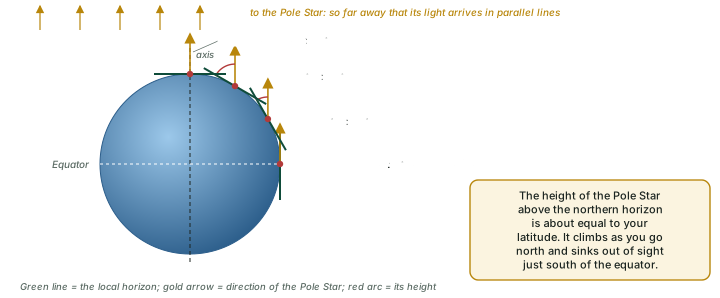
The Pole Star (Polaris) lies almost directly above the North Pole, in line with the Earth's axis, and it is so far away that its light reaches every part of the Earth along parallel lines. On a flat Earth it would stand at the same height in the sky everywhere. In fact its height above the northern horizon is roughly equal to the observer's latitude: on the horizon at the equator, about 30° up at 30° N, and overhead at the North Pole. Only a curved surface, with the local horizon tilting as you move, gives this (diagram below). The same tilting means that travellers going south see new southern stars rise into view.
Sunrise comes earlier to the east
On a turning sphere, places to the east turn into the sunlight first. Within India, NCERT notes a "time lag of two hours" between Gujarat in the west and Arunachal Pradesh in the east, which is why the Sun rises much earlier in the north-east (the section on Longitude and Time explains how clocks deal with this).
Going round it, and seeing it from space
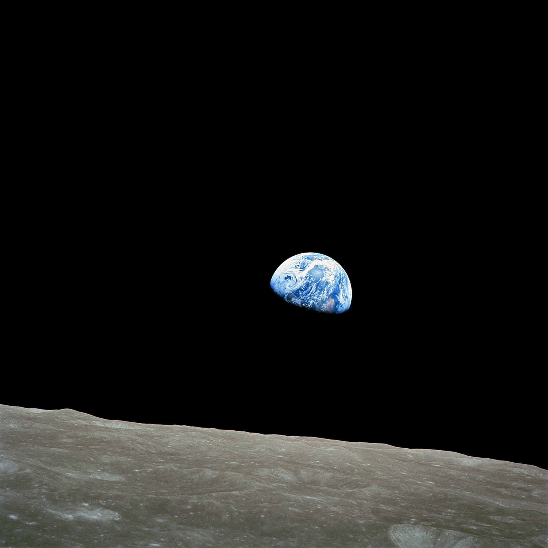
Ships and aircraft that keep travelling in one direction come back to where they started. Today the final proof is photographic: spacecraft have photographed the whole globe, and astronauts have seen its curve directly (diagram below).
Don't confuse
Going round proves less than it seems. A voyage round the world shows that the surface closes on itself, but a cylinder would also let you sail east until you return. It is the other clues together, the hull-first ship, the round shadow on the Moon, the changing height of the Pole Star, and photographs from space, that prove the shape is a sphere.
Six proofs of a round Earth
- Ship: hull disappears first.
- Height: the horizon moves farther away as you climb, d ≈ √(2Rh).
- Lunar eclipse: Earth's shadow is always round.
- Pole Star: its height ≈ your latitude.
- Sunrise: earlier in the east.
- Space: photographs of the whole globe.
Not quite a sphere: the oblate spheroid
The Earth is round, but not perfectly. It spins once a day, and a point on the equator travels a full 40,075 km circle in that time while a point near a pole barely moves. The outward effect of the spin is therefore strongest at the equator. Over geological time the planet, which can slowly flow at depth, has settled into a shape that bulges at the equator and is flattened at the poles. Geometers call this shape an oblate spheroid: an ellipse spun around its shorter axis.
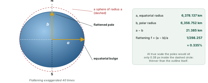
The standard model of this shape is the World Geodetic System 1984 (WGS 84) ellipsoid. Its equatorial radius a is 6,378.137 km and its flattening f = (a − b)/a is 1/298.257223563. From these two numbers everything else follows: the polar radius b = a(1 − f) = 6,356.752 km, only 21.4 km less. So the polar diameter is about 43 km shorter than the equatorial diameter (12,714 km against 12,756 km). Next to the Earth's size that is tiny, about 0.34%: drawn to scale, the Earth looks perfectly round.
| Number | What it is |
|---|---|
| 6,378 km | equatorial radius a (WGS 84: 6,378.137 km) |
| 6,357 km | polar radius b (computed: 6,356.752 km) |
| 21.4 km | how much shorter the polar radius is (a − b) |
| 1/298.26 | flattening f, about 0.335% |
| 40,075 km | equatorial circumference, 2πa |
| 510.1 M km² | surface area of the ellipsoid (computed) |
Defining values a and f: WGS 84 ellipsoid, EPSG:7030; the other numbers are computed from them (full values in the table below).
Why the equator bulges
Spin pushes outward most where the ground moves fastest, at the equator, and not at all at the poles. Two everyday consequences follow. The surface at the equator is farther from the centre than at the poles, and the outward push slightly offsets gravity there, so an object weighs very slightly less at the equator than at the poles. And because the Earth is flatter near the poles, a degree of latitude there covers slightly more ground than near the equator (the section on Latitude and Longitude gives the numbers).
The geoid: the shape of mean sea level
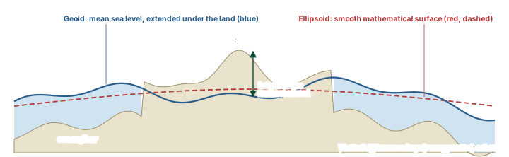
An ellipsoid is a smooth mathematical surface. The real Earth is not smooth even underneath its mountains, because rock of different density is spread unevenly inside it, so the pull of gravity is slightly stronger in some places than in others. If the oceans were left alone, without tides, currents or wind, the sea surface would follow these small differences in gravity. That surface, imagined as continuing under the continents, is the geoid. In the words of the US National Ocean Service, "The geoid is a model of global mean sea level that is used to measure precise surface elevations." Heights "above mean sea level" are heights above the geoid.
Don't confuse: Sphere, spheroid and geoid
- Sphere: a perfect ball; a good first picture of the Earth.
- Oblate spheroid (ellipsoid): a smooth ball flattened at the poles. It has an exact formula, so it serves as the reference surface for latitude, longitude and maps.
- Geoid: the true "level" surface, mean sea level extended under the land. Gently irregular, with no simple formula.
Textbooks often say "the Earth is a geoid". In an exam answer, say the Earth is an oblate spheroid in shape and that its true level surface is the geoid.
How big is the Earth?
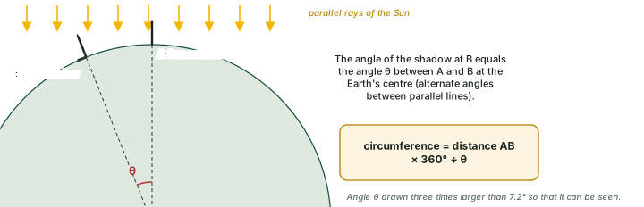
The size of the Earth can be measured with nothing more than sticks, shadows and a known distance. Pick two places on the same meridian. At noon on a day when the Sun is directly overhead at place A, a vertical stick there casts no shadow, while at place B, farther north, a stick casts a short shadow. Because the Sun is so far away its rays arrive in parallel, so the angle of the shadow at B equals the angle between A and B measured at the centre of the Earth (diagram below). That angle is the same fraction of 360° as the distance AB is of the whole circumference.
Worked example: the circumference from shadows
Two places on the same meridian are 800 km apart. At noon the Sun is overhead at one of them, and at the other a vertical stick's shadow shows the Sun is 7.2° from overhead. What is the Earth's circumference? (Example figures, chosen for easy arithmetic.)
- The angle at the Earth's centre equals the shadow angle: θ = 7.2°.
- 7.2° is 7.2/360 = 1/50 of a full circle.
- So the distance is 1/50 of the circumference: C = 800 × 50.
Answer: C = 40,000 km, close to the true 40,008 km measured round the poles.
The Earth's dimensions (WGS 84 ellipsoid)
| Quantity | Value | How it is obtained |
|---|---|---|
| Equatorial radius (a) | 6,378.137 km | WGS 84 defining value |
| Polar radius (b) | 6,356.752 km | b = a(1 − f) |
| Mean radius | 6,371.009 km | (2a + b)/3 |
| Equatorial diameter | 12,756.274 km | 2a |
| Polar diameter | 12,713.505 km | 2b |
| Flattening (f) | 1/298.257 = 0.3353% | WGS 84 defining value |
| Equatorial circumference | 40,075.017 km | 2πa |
| Meridional circumference (round the poles) | 40,007.863 km | perimeter of the ellipse with semi-axes a and b, by numerical integration |
| Surface area | 510.066 million km² | 2πa²[1 + (1 − e²)/e · artanh e], e² = f(2 − f) |
Defining values a = 6,378.137 km and 1/f = 298.257223563: WGS 84 ellipsoid, EPSG:7030 and NASA Earth Fact Sheet (updated 15 Nov 2024). Every other row is computed from them.
Exam tip
Learn the rounded set: equatorial radius 6,378 km, polar radius 6,357 km, equatorial circumference about 40,075 km, polar circumference about 40,008 km, surface area about 510 million km². A question that asks why the equatorial circumference is longer than the polar one is asking about the equatorial bulge caused by rotation.
A water planet
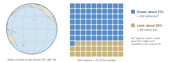
Seen from space, the Earth is mostly blue. NASA states that the ocean "covers about 71% of the planet's surface". That leaves about 29% as land, including the ice-covered land of Antarctica and Greenland. Applied to the surface area above, that is roughly 360 million km² of ocean and 150 million km² of land. The Pacific Ocean alone is so large that a globe turned to face it shows mostly ocean (diagram below).
Shape and size in three lines
The Earth is a sphere to the eye, an oblate spheroid to the geographer (bulging at the equator because it spins) and, in fine detail, a geoid (the true mean-sea-level surface). Its equatorial radius is 6,378 km, its polar radius 6,357 km, and about 71% of its surface is ocean.
Sources
Each table and data figure names its source beneath it. The main documents are collected here, with a date where the source carries one. Figures not listed under image credits were drawn for this page from the data and formulas stated in their source lines.
Main sources
| Topic | Source |
|---|---|
| Planets, the Sun and the Earth | NASA Planetary Fact Sheet (18 Mar 2025); NASA Earth Fact Sheet; NASA, Earth facts; NASA, Sun facts |
| Moons and dwarf planets | NASA, Saturn moons; NASA, Jupiter moons; NASA, Uranus moons; IAU, 26 Mar 2026; NASA, dwarf planets |
| Age of the Earth; time scale | USGS, Age of the Earth; ICS chart v2024/12; Anthropocene Working Group |
| Shape and size | WGS84 ellipsoid (EPSG:7030) |
Image credits
| Image | Credit and licence |
|---|---|
| Earthrise, 24 Dec 1968 (see the section on Shape and Size of the Earth) | Bill Anders, Apollo 8, NASA. Public domain. File page |
| World land outlines on maps | Natural Earth, 1:110m physical vectors. Public domain. |
| All other figures | Drawn for this page from the data and formulas given in their source lines. |