 BharatNotes
Part 8 of 11 of the Atmosphere and Climatology notes. The overview page has the quick revision and exam strategy for all eleven parts.
Tropical Cyclones, Thunderstorms and Tornadoes
The atmosphere's most destructive storms come in three sizes. A tropical cyclone spans hundreds of kilometres and lives for days; a single thunderstorm cell lasts about 30 to 60 minutes; a tornado is a spinning column that averages about 100 m across. This part explains how each forms and how each is measured. India's cyclone seasons, the Bay of Bengal and Arabian Sea compared, the North Indian Ocean naming list and the loo and Nor'westers are taught on the Monsoon Mechanism, Jet Streams and Tropical Cyclones page.
What a tropical cyclone is
NCERT's definition: "Tropical cyclones are violent storms that originate over oceans in tropical areas and move over to the coastal areas bringing about large scale destruction caused by violent winds, very heavy rainfall and storm surges." The US National Hurricane Center (NHC) adds what makes it different from the extratropical cyclones of the air masses and fronts part. It is "A warm-core non-frontal synoptic-scale cyclone, originating over tropical or subtropical waters, with organized deep convection and a closed surface wind circulation about a well-defined center." Two words matter: warm-core, because the centre is warmer than its surroundings, and non-frontal, because there are no fronts. The NHC goes on: "Once formed, a tropical cyclone is maintained by the extraction of heat energy from the ocean at high temperature and heat export at the low temperatures of the upper troposphere."
One storm, several names
NCERT: "They are known as Cyclones in the Indian Ocean, Hurricanes in the Atlantic, Typhoons in the Western Pacific and South China Sea, and Willy-willies in the Western Australia." The names are regional labels for one phenomenon. The NHC draws the lines precisely: "The term hurricane is used for Northern Hemisphere tropical cyclones east of the International Dateline to the Greenwich Meridian. The term typhoon is used for Pacific tropical cyclones north of the Equator west of the International Dateline." Australia's Bureau of Meteorology uses "tropical cyclone" on its own pages (Bureau of Meteorology, "Naming tropical cyclones").
Regional names for a tropical cyclone
| Name | Where it is used |
|---|---|
| Hurricane | Northern Hemisphere east of the International Dateline to the Greenwich Meridian (NHC); the Atlantic (NCERT) |
| Typhoon | Pacific north of the Equator, west of the International Dateline (NHC); Western Pacific and South China Sea (NCERT) |
| Cyclone | the Indian Ocean (NCERT) |
| Willy-willy | Western Australia (NCERT's list); the Bureau of Meteorology itself says "tropical cyclone" |
Source: NCERT, Fundamentals of Physical Geography, Class XI, ch 9 "Atmospheric Circulation and Weather Systems" (Reprint 2026-27); NOAA National Hurricane Center glossary; Bureau of Meteorology, "Naming tropical cyclones".
The word itself has an Indian history. The IMD notes that it comes from the Greek cyclos, meaning the coiling of a snake, and that it was coined by Henry Piddington, who worked as a Rapporteur in Kolkata during British rule (IMD, RSMC New Delhi FAQ on tropical cyclones).
Where and when they form
Stull: "Most tropical cyclones form between 10° and 30° latitude, which is the trade-wind region. Hence, most tropical cyclones are steered from east to west initially". None form on the equator itself: "Tropical cyclones cannot exist within about 500 km of the equator (i.e., ≤ 5° latitude), because Coriolis force is near zero there". Very small ones have rarely been seen closer, but none right at the equator. NCERT gives the same idea without a number, and adds what happens later in the track: "The cyclones, which cross 20° N latitude generally, recurve and they are more destructive."
The season follows the ocean's heat: "Tropical cyclones are most frequent in late Summer and Fall of their respective hemisphere. This is because the sun has been at its highest in the sky, causing the top layers of the tropical ocean to accumulate the most heat." Some oceans almost never produce them. The South Atlantic is the clearest case: Cyclone Catarina, which struck Brazil in March 2004, is one of very few tropical cyclones recorded there. India's cyclone seasons, and how the Bay of Bengal and the Arabian Sea differ, are taught on the Monsoon Mechanism, Jet Streams and Tropical Cyclones page.
The conditions for genesis
NCERT lists five: "The conditions favourable for the formation and intensification of tropical storms are: (i) Large sea surface with temperature higher than 27° C; (ii) Presence of the Coriolis force; (iii) Small variations in the vertical wind speed; (iv) A pre-existing weak-low-pressure area or low-level-cyclonic circulation; (v) Upper divergence above the sea level system." Research meteorology says the same things with numbers attached, and two of them differ slightly from the textbook.
Conditions for tropical-cyclone formation
| Condition | NCERT | Research and agency thresholds |
|---|---|---|
| Warm sea | surface temperature higher than 27 °C | about 26.5 °C or warmer (Stull; IMD), with the warm water at least about 50 m deep |
| Spin | presence of the Coriolis force | none within about 500 km (about 5°) of the equator (Stull; IMD) |
| Little shear | small variations in the vertical wind speed | shear under about 10 m/s (20 knots) between the lower (1.5 km) and upper (12 km) troposphere (IMD) |
| A seed | a pre-existing weak low or low-level cyclonic circulation | a pre-existing near-surface disturbance with enough spin and inflow (IMD); triggers include the ITCZ, African easterly waves, the monsoon trough and mid-latitude fronts (Stull) |
| Outflow aloft | upper divergence above the sea-level system | heat exported at the cold upper troposphere (NHC) |
Source: NCERT, Fundamentals of Physical Geography, Class XI, ch 9 "Atmospheric Circulation and Weather Systems" (Reprint 2026-27); R. Stull, Practical Meteorology (Univ. of British Columbia, via LibreTexts), section 16.3; IMD, RSMC New Delhi FAQ on tropical cyclones; NOAA National Hurricane Center glossary.
Stull's full list has seven items: "Seven conditions are necessary for tropical cyclones to form: a warm sea surface, non-zero Coriolis force, nonlocal conditional instability, high humidity in the mid troposphere, weak ambient wind shear, enhanced synoptic-scale vorticity, and a trigger." The two that NCERT leaves out, instability and a moist middle troposphere, are what let deep thunderstorms grow.
Why the depth of warm water matters: the storm's own waves stir the top of the ocean. Stull says the SST "must be approximately 26.5°C or warmer" and "the warm surface waters must be at least 50 m deep". If the warm layer is too shallow, the stirring brings colder, deeper water up, the surface falls below 26.5 °C, and "the tropical cyclone kills itself." The IMD adds that its conditions "are necessary but not sufficient": all of them can be present and still no cyclone forms.
Don't confuse
NCERT's threshold is "higher than 27° C"; Stull and the IMD use about 26.5 °C. Use NCERT's figure for a textbook question and know that 26.5 °C is the figure used in research and by the IMD.
Energy and structure
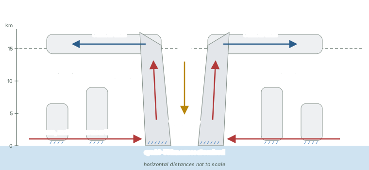
NCERT's account of the engine: "The energy that intensifies the storm, comes from the condensation process in the towering cumulonimbus clouds, surrounding the centre of the storm. With continuous supply of moisture from the sea, the storm is further strengthened. On reaching the land the moisture supply is cut off and the storm dissipates." Warm, moist air spirals in near the sea surface, rises in the ring of towering clouds round the centre, releases its latent heat (see the water in the atmosphere part) and flows out at the top. "The place where a tropical cyclone crosses the coast is called the landfall of the cyclone."
Eye, eyewall and rain bands
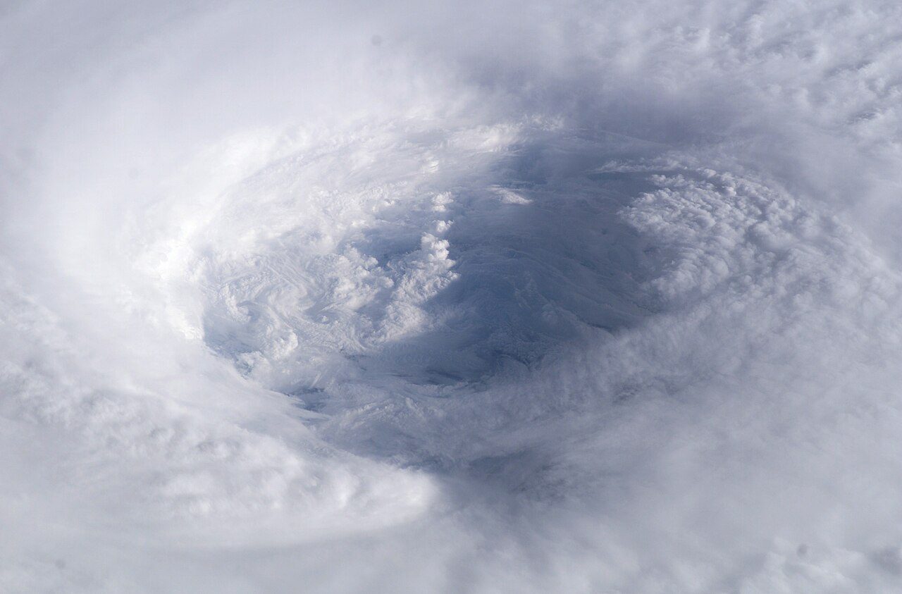
- Eye. NCERT: "The eye is a region of calm with subsiding air." Stull: "In the middle of the eyewall is a calmer region called the eye with warm temperatures, subsiding (sinking) air, and fewer or no clouds." "Eye diameter at sea level is 20 to 50 km. The eye is conical, with the larger diameter at the storm top".
- Eyewall. The ring of thunderstorms round the eye, the most violent part of the storm with the heaviest rain (Stull). NCERT: "Around the eye is the eye wall, where there is a strong spiralling ascent of air to greater height reaching the tropopause. The wind reaches maximum velocity in this region, reaching as high as 250 km per hour." Stull puts the tallest eyewall tops at 15 to 18 km, in the lower stratosphere.
- Rain bands. Bands of thunderstorms spiral out from the eyewall; NCERT says "rain bands may radiate" from it.
- Eyewall replacement. Spiral bands sometimes merge into a temporary second eyewall round the first; the lighter rain between the two is the moat. In very strong storms "the inner eyewall dissipates and is replaced by the outer eyewall". Intensity sometimes drops for a while, then recovers as the new eyewall shrinks to the size of the old one (Stull).
Don't confuse
NCERT also says that "The diameter of the circulating system can vary between 150 and 250 km", next to its description of the eye. NCERT does not say exactly what this measures. Do not read it as the size of the eye, which Stull gives as 20-50 km across at sea level.
Size and movement
Sources give different sizes because they measure different things and different basins. NCERT: "The diameter of the storm over the Bay of Bengal, Arabian sea and Indian ocean is between 600 - 1200 km. The system moves slowly about 300 - 500 km per day." The IMD's general description is "a vast violent whirl of 150 to 800 km, spiraling around a centre and progressing along the surface of the sea at a rate of 300 to 500 km a day." Both agree on the speed of travel. The IMD also gives the extremes: Typhoon Tip (12 October 1979) had gale-force winds out to a radius of 1,100 km; Tropical Cyclone Tracy (24 December 1974) had gale-force winds out to only 50 km when it struck Darwin, Australia (IMD, RSMC New Delhi FAQ on tropical cyclones).
Measuring intensity
Agencies classify storms by their maximum sustained wind, but "sustained" is averaged over different times. The IMD: "India Meteorological Department (IMD) uses a 3 minutes averaging for the sustained wind." The NHC uses one minute. Stull notes that "some agencies use 1-minute average (sustained) winds, some use 10-minute average (sustained) winds, and some use gusts." A shorter average catches more of the peaks, so the same storm gives different numbers on different scales, and categories from two scales cannot be matched one to one.
The NHC classes and the Saffir-Simpson scale
With 1-minute winds, the NHC calls a tropical cyclone a tropical depression at 33 knots (62 km/h) or less, a tropical storm at 34-63 knots (63-118 km/h) and a hurricane (or typhoon) at 64 knots (119 km/h) or more. Hurricanes are then rated by the Saffir-Simpson scale. The NHC is explicit about what it measures: "The Saffir-Simpson Hurricane Wind Scale is a 1 to 5 rating based only on a hurricane's maximum sustained wind speed. This scale does not take into account other potentially deadly hazards such as storm surge, rainfall flooding, and tornadoes." A Category 1 storm can therefore still bring a deadly flood.
The Saffir-Simpson Hurricane Wind Scale
| Category | Sustained wind (1-min) | km/h | NHC's damage wording |
|---|---|---|---|
| 1 | 64-82 kt (74-95 mph) | 119-153 | Very dangerous winds will produce some damage |
| 2 | 83-95 kt (96-110 mph) | 154-177 | Extremely dangerous winds will cause extensive damage |
| 3 (major) | 96-112 kt (111-129 mph) | 178-208 | Devastating damage will occur |
| 4 (major) | 113-136 kt (130-156 mph) | 209-251 | Catastrophic damage will occur |
| 5 (major) | 137 kt or higher (157 mph or higher) | 252 or higher | Catastrophic damage will occur; most of the area uninhabitable for weeks or months |
Source: NOAA NHC, "Saffir-Simpson Hurricane Wind Scale"; "major hurricane" (Category 3 or higher) from the NOAA National Hurricane Center glossary.
Two more NHC terms are worth knowing. Rapid intensification is "An increase in the maximum sustained winds of a tropical cyclone of at least 30 kt in a 24-h period", about 56 km/h in a day. And super typhoon is a term of the US Joint Typhoon Warning Center for typhoons with 1-minute sustained winds of at least 130 knots (65 m/s) (IMD, RSMC New Delhi FAQ on tropical cyclones).
The IMD scale
IMD classes of cyclonic disturbances, North Indian Ocean
| Class | 3-min sustained wind (knots) | km/h |
|---|---|---|
| Low pressure area | below 17 | below 31 |
| Depression | 17-27 | 31-49 |
| Deep Depression | 28-33 | 50-61 |
| Cyclonic Storm | 34-47 | 62-88 |
| Severe Cyclonic Storm | 48-63 | 89-117 |
| Very Severe Cyclonic Storm | 64-89 | 118-166 |
| Extremely Severe Cyclonic Storm | 90-119 | 167-221 |
| Super Cyclonic Storm | 120 and above | 222 and above |
Source: IMD, RSMC New Delhi FAQ on tropical cyclones (the FAQ is undated). The Indian use of the scale is taught on the Monsoon Mechanism, Jet Streams and Tropical Cyclones page.
Worked example: Reading one wind speed on two scales
A storm's maximum sustained wind is reported as 100 knots. Convert it to km/h and place it on the Saffir-Simpson scale and the IMD scale.
- 1 knot = 1.852 km/h, so 100 kt × 1.852 = 185 km/h.
- Saffir-Simpson: 100 kt lies in 96-112 kt, so Category 3, a major hurricane.
- IMD: 100 kt lies in 90-119 kt, so an Extremely Severe Cyclonic Storm.
- Caution: the NHC figure is a 1-minute average and the IMD figure a 3-minute average. An agency measuring the same storm would not report the same 100 kt on both, so this is a reading exercise, not a conversion.
Answer: about 185 km/h (computed): Category 3 on Saffir-Simpson; ESCS on the IMD scale.
Naming
Storms are named by the regional specialised meteorological centres (RSMCs) from lists agreed by regional bodies. Among the WMO's reasons: to identify each individual cyclone, and to avoid confusion when more than one is active over a region. Six RSMCs name storms worldwide (WMO news, 1 May 2020). The North Indian Ocean panel, its member countries and its list of names are taught on the Monsoon Mechanism, Jet Streams and Tropical Cyclones page.
Hazards: surge, rain and tornadoes
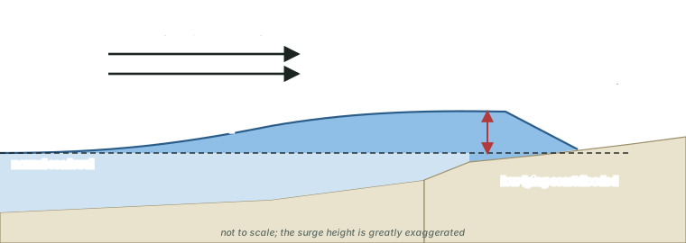
Wind is only one of the dangers. The NHC defines storm surge as "An abnormal rise in sea level accompanying a hurricane or other intense storm, and whose height is the difference between the observed level of the sea surface and the level that would have occurred in the absence of the cyclone." Two things raise the water: onshore winds pile it against the coast, and the low pressure of the storm lets the sea bulge up. Stull: "Typical surge depths can be 2 to 10 m at the coast, with extreme values of 13 to 20 m." NCERT: "The cyclone creates storm surges and they inundate the coastal low lands."
Heavy rain from decaying tropical storms also brings inland flooding, a major killer (Stull). Tropical cyclones can also spawn tornadoes (see tornadoes, below).
World records
Tropical-cyclone and tornado records
| Record | Value | Where and when |
|---|---|---|
| Lowest sea-level pressure (excluding tornadoes) | 870 hPa | eye of Typhoon Tip, 12 October 1979 |
| Highest tropical-cyclone gust | 113.2 m/s (253 mph; 220 kt), about 408 km/h | Barrow Island, Australia, 10 April 1996 |
| Deadliest tropical cyclone | estimated 300,000 deaths | coastal Bangladesh, 12-13 November 1970 |
| Deadliest tornado | estimated 1,300 deaths | Manikganj district, Bangladesh, 26 April 1989 |
Source: WMO, "Records of Weather and Climate Extremes", as of 31 July 2025. km/h computed: 113.2 × 3.6 = 407.5.
For the North Indian Ocean, the IMD's FAQ calls the Odisha super cyclone of 29 October 1999 "the most intense cyclonic storm over north Indian Ocean in the recorded history of the region", with a lowest estimated central pressure of 912 hPa (IMD, RSMC New Delhi FAQ on tropical cyclones; the FAQ is undated). Its story is on the Monsoon Mechanism, Jet Streams and Tropical Cyclones page.
Thunderstorms
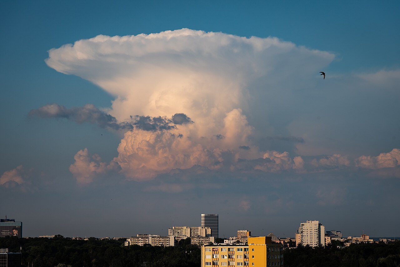
NCERT: "Thunderstorms are caused by intense convection on moist hot days. A thunderstorm is a well-grown cumulonimbus cloud producing thunder and lightening [sic]." Stull describes the same cloud: "Thunderstorms are convective clouds with large vertical extent, often with tops near the tropopause and bases near the top of the boundary layer. Their official name is cumulonimbus". The flat, spreading top is the anvil (official name incus, Latin for anvil). Strictly, "Not all cumulonimbus clouds have lightning and thunder"; without them the storm is technically not a thunderstorm.
The life of a cell
NCERT gives the basic sequence: "A thunderstorm is characterised by intense updraft of rising warm air, which causes the clouds to grow bigger and rise to greater height. This causes precipitation. Later, downdraft brings down to earth the cool air and the rain." Stull divides it into three stages: "Its evolution has three stages: (1) towering-cumulus; (2) mature; and (3) dissipation". "Each individual cell lasts about 30 to 60 min."
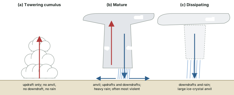
- Towering cumulus: "The towering cumulus stage consists of only updraft in a rapidly growing cumulus congestus tower. It has no anvil, no downdrafts, and no precipitation."
- Mature: "the thunderstorm has an anvil, both updrafts and downdrafts, and heavy precipitation of large-size drops." It is often the most violent time, with possible lightning, strong turbulence and winds.
- Dissipating: "In the dissipating stage, the storm consists of downdrafts, precipitation, and a large glaciated (containing ice crystals) anvil."
Why does a single cell die so quickly? Stull: "In the absence of wind shear, two factors conspire to limit the lifetime of the storm [...]: (1) the storm runs out of fuel as it consumes nearby boundary-layer air; and (2) the colder outflow air chokes off access to adjacent warm boundary-layer air." The cold downdraft, in other words, cuts off the warm air that fed the updraft.
Hail and dust
NCERT: "When the clouds extend to heights where sub-zero temperature prevails, hails are formed and they come down as hailstorm. If there is insufficient moisture, a thunderstorm can generate dust-storms."
Three kinds of thunderstorm
Thunderstorm types
| Type | What it is | Life and character |
|---|---|---|
| Airmass (single-cell) | one cell | about 30-60 minutes, the life of one cell |
| Multicell | one cloud mass holding 2 to 5 cells at different stages | new cells form as old ones decay; "Most thunderstorms in North America are multicell storms" |
| Supercell | one large storm with a rotating updraft (a mesocyclone) | the most severe, long-lasting (for hours) and less frequent; the source of the most violent tornadoes and hail |
Source: R. Stull, Practical Meteorology (Univ. of British Columbia, via LibreTexts), sections 14.1, 15.4.
What a severe storm needs
Stull: "Four environmental (pre-storm) conditions are needed to form the strong moist convection that is a severe thunderstorm": high humidity in the boundary layer, nonlocal conditional instability, strong wind shear, and a trigger mechanism to lift the boundary-layer air. Lifted air cools until it saturates at the lifting condensation level (LCL). Pushed higher, it reaches the level of free convection (LFC), where it becomes warmer than its surroundings, and then rises on its own up to its neutrally buoyant equilibrium level (EL) (the water in the atmosphere part explains the lapse rates behind this). In strong upper winds the anvil can be "100 km wide (crosswind) and 300 km long (downwind)". Where the strongest updraft punches above the anvil it makes an overshooting top, and "Storms that have overshooting tops are often more violent and turbulent."
Tornadoes
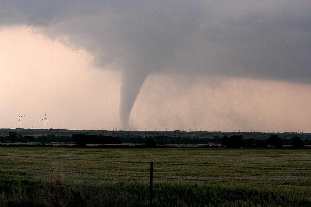
NCERT: "From severe thunderstorms sometimes spiralling wind descends like a trunk of an elephant with great force, with very low pressure at the centre, causing massive destruction on its way. Such a phenomenon is called a tornado. Tornadoes generally occur in middle latitudes. The tornado over the sea is called water spouts."
Stull's definition: "Tornadoes are violently rotating, small-diameter columns of air in contact with the ground. Diameters range from 10 to 1000 m, with an average of about 100 m." "Tornadoes are usually formed by thunderstorms, but most thunderstorms do not spawn tornadoes. The strongest tornadoes come from supercell thunderstorms." Wind speeds round them range from about 18 m/s in weak tornadoes to more than 140 m/s in exceptionally strong ones, and fewer than 2 per cent rotate anticyclonically.
How the spin is made
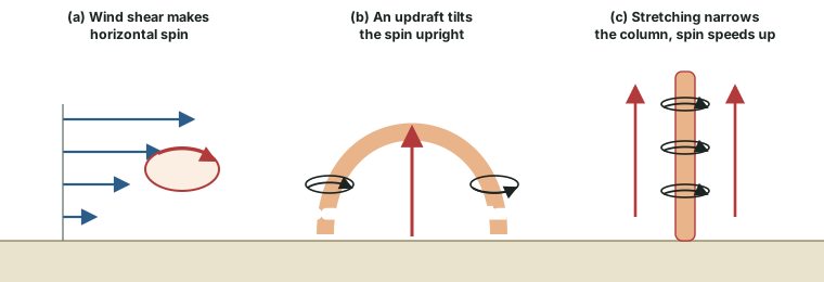
Wind that grows stronger with height (shear) makes the air roll about a horizontal axis. Stull: "rotation about a vertical axis can increase (i.e., spin up) if horizontal vorticity is tilted into the vertical, or if the volume of air containing this vertical vorticity is stretched in the vertical". A supercell's updraft tilts the roll upright, making the slowly rotating mesocyclone; stretching then narrows the spinning column and speeds it up, as a skater spins faster with arms pulled in.
The funnel is not the tornado
The visible funnel is cloud: "The water-condensation funnel is caused by low pressure inside the tornado, which allows air to expand as it is sucked horizontally toward the core. As the air expands it cools, and can reach saturation if the pressure is low enough and the initial humidity of the air is great enough." Sometimes only part of a tornado is visible, and rarely none of it: "Regardless of whether you can see the tornado, if the structure consists of a violently rotating column of air, then it is classified as a tornado." Stull traces a supercell tornado through five stages, from a dust swirl at the ground, through a developing funnel and the mature stage ("This is the stage when tornadoes are most destructive."), to a weakening, slender rope, until the funnel disappears up into the cloud base.
Kinds of tornado and look-alikes
| Kind | Description (Stull) |
|---|---|
| Supercell tornado | from a rotating supercell; the most violent |
| Landspout | weaker (about EF0-EF2), not usually from a supercell; short-lived; forms along strong cold fronts |
| Waterspout | like a landspout but over water; 3-100 m across; under cumulus congestus or small thunderstorms; usually 5-10 minutes, weak (EF0-EF1) |
| Cold-air funnel | very short-lived (1-3 minutes), weak, usually does not reach the ground |
| Dust devil | not a tornado and not linked to thunderstorms: a fair-weather vortex in a clear-air thermal over heated ground |
Source: R. Stull, Practical Meteorology (Univ. of British Columbia, via LibreTexts), section 15.4.
The Enhanced Fujita scale
Tornado winds are rarely measured directly, so tornadoes are rated from the damage they do. "The Enhanced Fujita Scale or EF Scale, which became operational on February 1, 2007, is used to assign a tornado a 'rating' based on estimated wind speeds and related damage" (US NWS Norman, "The Enhanced Fujita Scale"). The speeds are estimated 3-second gusts, judged by comparing the damage with 28 damage indicators (DIs) and their degrees of damage (DoD). They are estimates, not measurements.
The Enhanced Fujita (EF) scale
| Rating | 3-second gust (mph) | km/h (computed) |
|---|---|---|
| EF0 | 65-85 | 105-137 |
| EF1 | 86-110 | 138-177 |
| EF2 | 111-135 | 179-217 |
| EF3 | 136-165 | 219-265 |
| EF4 | 166-200 | 267-322 |
| EF5 | over 200 | over 322 |
Source: US NWS Norman, "The Enhanced Fujita Scale". km/h computed at 1 mph = 1.609 km/h and rounded.
Don't confuse
A tornado is 10 to 1,000 m across (Stull); a tropical cyclone is a whirl of 150 to 800 km (IMD). They are different storms on different scales: Saffir-Simpson or the IMD scale for cyclones, the EF scale for tornadoes.
Downbursts
Not every wind disaster under a thunderstorm is a tornado. Stull: "Downbursts are rapidly descending (w = –5 to –25 m s–1) downdrafts of air ..., found below clouds with precipitation or virga. Downbursts of 0.5 to 10 km diameter are usually associated with thunderstorms and heavy rain." When the falling air hits the ground it spreads out as straight-line winds, with no rotation.
Summary
- 27 / 26.5 °C sea temperature: NCERT / Stull and IMD
- 10°-30° latitudes where most tropical cyclones form
- 20-50 km eye diameter at sea level (Stull)
- 870 hPa record low pressure, Typhoon Tip, 1979 (WMO)
In one minute
- A tropical cyclone is warm-core and has no fronts; it runs on latent heat from condensation and dies over land.
- Names: cyclone (Indian Ocean), hurricane (Atlantic and NE Pacific), typhoon (NW Pacific), willy-willy (NCERT, Western Australia).
- Genesis: warm sea (NCERT 27 °C; 26.5 °C, 50 m deep), Coriolis (not within about 500 km of the equator), low shear, a seed disturbance, outflow aloft.
- Structure: calm sinking eye, violent eyewall with tops at 15-18 km, spiral rain bands.
- Scales differ in averaging time: NHC 1 minute, IMD 3 minutes, some agencies 10 minutes.
- Storm surge: sea above its no-storm level; 2-10 m typical, 13-20 m extreme.
- Thunderstorm cell: towering cumulus, mature, dissipating; 30-60 minutes.
- Tornado: 10-1,000 m wide; spin tilted upright and stretched; rated on the EF scale (from 1 February 2007).
Sources
Each table and data figure names its source beneath it. The main documents are collected here, with a date where the source carries one. Figures not listed under image credits were drawn for this page from the sources stated in their source lines.
Main sources
| Topic | Source |
|---|---|
| Textbook | NCERT, Fundamentals of Physical Geography, Class XI, ch 9 "Atmospheric Circulation and Weather Systems" (Reprint 2026-27) |
| Definitions, regional names, intensity classes, rapid intensification, storm surge | NOAA National Hurricane Center glossary |
| Saffir-Simpson scale | NOAA NHC, "Saffir-Simpson Hurricane Wind Scale" |
| Origin of the word, genesis thresholds, size, IMD classes, super typhoon, Odisha 1999 | IMD, RSMC New Delhi FAQ on tropical cyclones (undated) |
| Australian usage | Bureau of Meteorology, "Naming tropical cyclones" |
| Naming by RSMCs | WMO news, 1 May 2020 |
| Formation, structure and hazards of tropical cyclones | R. Stull, Practical Meteorology (Univ. of British Columbia, via LibreTexts): section 16.1, section 16.3, section 16.8 |
| Thunderstorms and tornadoes | R. Stull, Practical Meteorology (Univ. of British Columbia, via LibreTexts): section 14.1, section 15.4 |
| Glossary definitions (eye, shelf cloud, waterspout) | NWS glossary: "eye", "shelf cloud", "waterspout" |
| World records | WMO, "Records of Weather and Climate Extremes", as of 31 July 2025 |
| Enhanced Fujita scale | US NWS Norman, "The Enhanced Fujita Scale" |
Image credits
| Image | Credit and licence |
|---|---|
| The eye of Hurricane Isabel from the International Space Station, 13 September 2003 | NASA astronaut Ed Lu. Public domain, via Wikimedia Commons. File page |
| Cumulonimbus with its anvil (incus) over Warsaw, Poland, 27 June 2020 | Kamil Nowacki. CC BY-SA 4.0, via Wikimedia Commons. File page |
| Shelf cloud over Asprovalta, Greece, 24 May 2019 | Neptuul. CC BY-SA 4.0, via Wikimedia Commons. File page |
| A tornado over the plains of Kansas, 23 May 2008 | Sean Waugh NOAA/NSSL. Public domain, via Wikimedia Commons. File page |
| A waterspout off the Florida Keys, 10 September 1969 | NOAA/NOS-NGS/Steve Nicklas. Public domain, via Wikimedia Commons. File page |
| All other figures | Drawn for this page from the sources given in their source lines. |




