 BharatNotes
Part 7 of 11 of the Atmosphere and Climatology notes. The overview page has the quick revision and exam strategy for all eleven parts.
Air Masses, Fronts and Extratropical Cyclones
Most of the day-to-day weather of the middle latitudes is made where two great bodies of air meet. This part starts with the bodies themselves, the air masses, then follows what happens at their boundaries, the fronts, and ends with the storms that grow on those boundaries: the extratropical cyclones, with their partners the anticyclones. NCERT's account comes first in each section, because it is the exam baseline; the modern meteorology that sharpens it follows.
Air masses
NCERT starts from a simple observation: "When the air remains over a homogenous area for a sufficiently longer time, it acquires the characteristics of the area." The area can be a vast ocean surface or a vast plain. "The air with distinctive characteristics in terms of temperature and humidity is called an airmass. It is defined as a large body of air having little horizontal variation in temperature and moisture." The surfaces over which air masses form are their source regions.
Stull adds the scale: "An airmass is a widespread (of order 1000 km wide) body of air in the bottom third of the troposphere that has somewhat-uniform characteristics." He also explains where they form: "Surface high-pressure centers favor the formation of airmasses because the calm or light winds allow long residence times." That is why many source regions coincide with the large high-pressure regions of the general circulation part, such as the subtropical highs and the polar highs.
NCERT's five types
NCERT recognises five major source regions and five matching air masses. Read the code letter by letter: the small letter says whether the air formed over sea (m, maritime) or land (c, continental), and the capital says how far poleward it formed. In NCERT's summary, "Tropical air masses are warm and polar air masses are cold."
NCERT's five air masses
| Code | Name | Source region (NCERT) | Character (from the letters) |
|---|---|---|---|
| mT | Maritime tropical | warm tropical and subtropical oceans | humid, warm |
| cT | Continental tropical | the subtropical hot deserts | dry, warm |
| mP | Maritime polar | the relatively cold high-latitude oceans | humid, cold |
| cP | Continental polar | the very cold snow-covered continents in high latitudes | dry, cold |
| cA | Continental arctic | permanently ice-covered continents in the Arctic and Antarctica | dry, very cold |
Source: NCERT, Fundamentals of Physical Geography, Class XI, ch 9 "Atmospheric Circulation and Weather Systems" (Reprint 2026-27); meaning of the letters from R. Stull, Practical Meteorology (Univ. of British Columbia, via LibreTexts), section 12.2 (Table 12-1). NCERT lists the regions and the types in the same order.
The full letter code
Meteorologists use a wider code built on the same idea. Stull: "The first letter, in lowercase, describes the humidity source. The second letter, in uppercase, describes the temperature source." Besides A, P and T, the second letter can be E (equatorial, hot), M (monsoon, similar to tropical) or S (superior, a warm dry air mass whose origin is aloft); his table also lists AA (Antarctic) for exceptionally cold, dry air. Stull's examples are maritime tropical air "such as can form over the Gulf of Mexico" and continental polar air "such as can form in winter over Canada". He also notes that "Some meteorologists change all “mE” to “mT”, and “cAA” to “cA”", which is close to NCERT's simpler scheme.
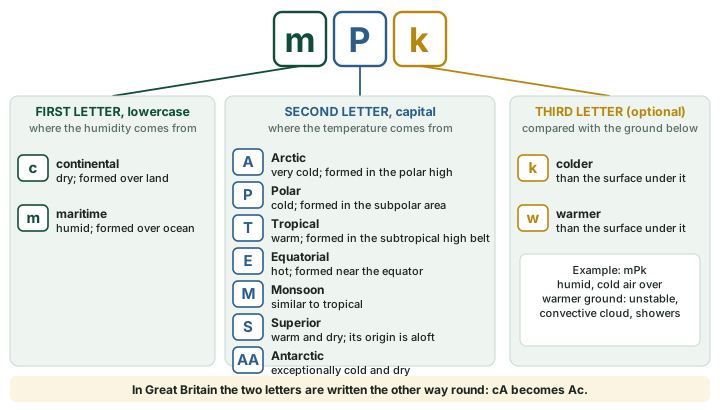
An optional third letter says how the air compares with the surface it is now crossing: k if the air is colder than the ground below, w if it is warmer. This is where an air mass starts to change. Stull's example: "“mPk” is humid cold air moving over warmer ground, which would likely be statically unstable and have convective clouds and showers." Air that is warmer than the ground is cooled from below and becomes more stable (the temperature part shows how such cooling builds an inversion).
Don't confuse
British usage reverses the letters. Stull's caution: "In Great Britain, the two letters are reversed." His example is continental arctic air, which "In Great Britain, the same airmass is labeled as Ac." If a British text writes Pm, it means the same air as mP.
Fronts
NCERT: "When two different air masses meet, the boundary zone between them is called a front. The process of formation of the fronts is known as frontogenesis." There are four types: cold, warm, stationary and occluded. "The fronts occur in middle latitudes and are characterised by steep gradient in temperature and pressure. They bring abrupt changes in temperature and cause the air to rise to form clouds and cause precipitation."
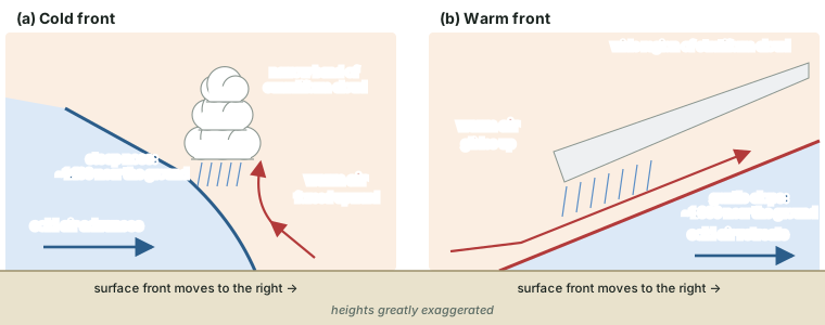
Which front is which depends on which air is advancing. NCERT puts it this way: when the cold air moves towards the warm air mass, the contact zone is a cold front; when the warm air mass moves towards the cold air mass, it is a warm front; when the front does not move, it is a stationary front. Stull says the same thing from the cold side: "Advancing cold air at the surface defines the cold front, where the front moves toward the warm airmass", while "Retreating cold air defines the warm front, where the front moves toward the cold airmass".
Why fronts slope
Cold air is denser, so it always lies underneath as a wedge, and the boundary leans back over the cold air. The slopes are gentle: Stull notes that "Within about 200 m of the surface, there are appreciable differences in frontal slope. The cold front has a steeper nose (slope ≈ 1 : 100) than the warm front (slope ≈ 1 : 300), although wide ranges of slopes have been observed." A slope of 1:300 means the frontal surface climbs only about 1 km for every 300 km of distance, so a warm front announces itself in the sky long before it reaches the ground below.
Weather at each front
NCERT describes both in its account of the temperate cyclone. Ahead of the warm front, "The warm air glides over the cold air and a sequence of clouds appear over the sky ahead of the warm front and cause precipitation." At the cold front, "The cold front approaches the warm air from behind and pushes the warm air up. As a result, cumulus clouds develop along the cold front."
Stull adds a refinement based on what the warm air does above the front. If the warm air flows down the frontal surface, the front is a katafront; if it flows up the frontal surface, it is an anafront. "Frequently in central N. America, the cold fronts are katafronts", with "the narrow band of cumuliform clouds that is typical along the front". "It is also common that warm fronts are anafronts, which leads to a wide region of stratiform clouds". A stationary front "is like an anafront where the cold air neither advances nor retreats." Stormy weather can also run ahead of a cold front: "Sometimes a squall line of thunderstorms will form in advance of the front, in the warm air." Thunderstorms themselves are treated in the tropical cyclones, thunderstorms and tornadoes part.
The four fronts compared
| Front | What moves | Slope near the ground | Typical cloud and weather |
|---|---|---|---|
| Cold | cold air advances; the front moves towards the warm air | steeper, ~1:100 | warm air pushed up; cumulus along the front (NCERT); often a narrow band of cumuliform cloud; a squall line may form ahead, in the warm air |
| Warm | cold air retreats; the front moves towards the cold air | gentler, ~1:300 | warm air glides up; clouds and precipitation ahead of the front (NCERT); often a wide region of stratiform cloud |
| Stationary | neither air mass advances | not given | like an anafront in which the cold air neither advances nor retreats |
| Occluded | the cold front overtakes the warm front | not given | the warm air is lifted off the ground (see occluded fronts, below) |
Source: NCERT, Fundamentals of Physical Geography, Class XI, ch 9 "Atmospheric Circulation and Weather Systems" (Reprint 2026-27); R. Stull, Practical Meteorology (Univ. of British Columbia, via LibreTexts), sections 12.3, 12.6. Slopes are Stull's values within about 200 m of the surface; wide ranges are observed.
Remember
Both definitions turn on the cold air. Cold air advancing: cold front. Cold air retreating (so the warm air takes its place): warm front. Neither: stationary front. Cold front overtaking warm front: occluded front.
Occluded fronts
NCERT gives the exam definition in one line: "If an air mass is fully lifted above the land surface, it is called the occluded front." It happens because "The cold front moves faster than the warm front ultimately overtaking the warm front." The warm air that used to sit between the two fronts is squeezed upwards and loses contact with the ground.
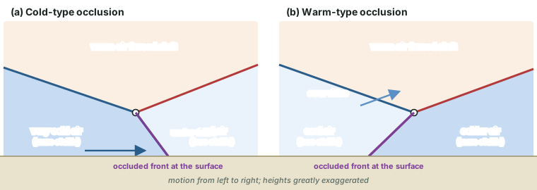
Stull distinguishes two kinds, according to which of the two cold air masses is colder and more stable.
- In a cold-front occlusion, "very cold air that is very statically stable catches up to, and under-rides, cooler air that is less statically stable." "Most occlusions in interior N. America are of this type".
- In a warm-front occlusion, "cool air that is less statically stable catches up to, and over-rides, colder air that is more statically stable". "Most occlusions in Europe and the Pacific Northwest USA are this type".
On a surface map, the point "where the cold, warm, and occluded fronts intersect at the surface is called the triple point".
The polar-front theory
Much of this vocabulary comes from one group of Norwegian scientists. Stull's account: during the First World War, "Vilhelm Bjerknes, a Norwegian physicist with expertise in radio science and fluid mechanics, was asked in 1918 to form a Geophysical Institute in Bergen, Norway." Cut off from weather data by the war, he had "a dense network of 60 surface weather stations" installed. His son Jacob Bjerknes used the station data to identify and classify cold, warm and occluded fronts. On the name, Stull writes: "The term “front” supposedly came by analogy to the battle fronts during the war."
The key papers are Jacob Bjerknes, "On the structure of moving cyclones" (Monthly Weather Review 47: 95-99, 1919), and J. Bjerknes and H. Solberg, "Life cycle of cyclones and the polar front theory of atmospheric circulation" (Geofysiske Publikasjoner 3(1), 1922). Their description of the cyclone life cycle is known as the Norwegian cyclone model. Among the students of the Bergen school Stull lists C.-G. Rossby, whose waves appear in the jet streams and general circulation part, and T. Bergeron.
Don't confuse
Vilhelm Bjerknes founded the Bergen institute (1918). The front and cyclone-model papers are by his son Jacob Bjerknes (1919) and by Jacob Bjerknes with H. Solberg (1922). Do not credit the polar-front model to Vilhelm alone.
The life cycle of an extratropical cyclone
NCERT: "The systems developing in the mid and high latitude, beyond the tropics are called the middle latitude or extra tropical cyclones." They are the travelling lows of the westerlies, and NCERT ties them to the polar front: "Extra tropical cyclones form along the polar front. Initially, the front is stationary."
The textbook sequence
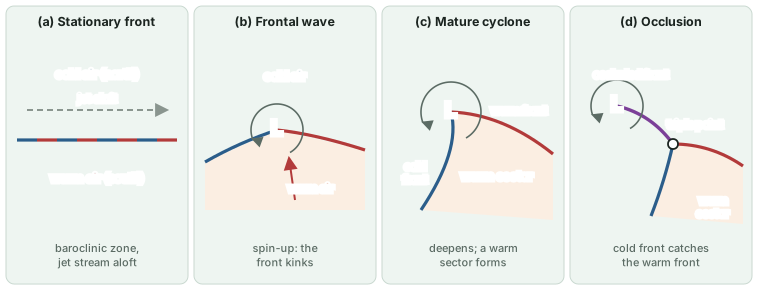
NCERT continues, for the northern hemisphere: warm air blows from the south and cold air from the north of the front. "When the pressure drops along the front, the warm air moves northwards and the cold air move towards, south setting in motion an anticlockwise cyclonic circulation." The result is a well-developed cyclone with a warm front and a cold front, and "pockets of warm air or warm sector wedged between the forward and the rear cold air or cold sector." The cold front then catches the warm front: "The warm air is completely lifted up and the front is occluded and the cyclone dissipates."
The stages in modern terms
Stull follows the same storm in more detail. "One condition that favors cyclogenesis is a baroclinic zone", a long, narrow region of large temperature change near the surface, which is what a stationary front is, and above it there is often a strong jet stream. As pressure falls, the front kinks: "The kinked front is wave shaped, and is called a frontal wave." Stull calls this "the spin-up stage", named for the vorticity that increases as the cyclone intensifies. The low deepens and the warm sector opens out between the fronts. Near the time of strongest winds the cold front catches up with the warm front near the low centre, and the occluded front forms. The low then weakens, surrounded by cool air; the drier air wrapping into it shows on satellite images as a "dry tongue". Birth and growth is cyclogenesis; decay is cyclolysis.
Stull's figures for the life span: "Life cycles of 1 day to 2 weeks have been observed, with 3 days being typical", and "Cyclones in the Northern Hemisphere typically evolve during a 2 to 7 day period, with most lasting 3 - 5 days." They also travel, carried east by the westerlies at typical speeds of 12 to 15 m/s (43 to 54 km/h), "which means they can move about 5000 km during their life".
Worked example: How far does a temperate cyclone travel?
A northern-hemisphere cyclone moves east at 12-15 m/s and lives 4 days (the middle of Stull's usual 3-5). How far does it go?
- One day is 24 × 3,600 = 86,400 seconds.
- At 12 m/s: 12 × 86,400 = 1,036,800 m, about 1,037 km a day.
- At 15 m/s: 15 × 86,400 = 1,296,000 m, about 1,296 km a day.
- Over 4 days: about 4,147 to 5,184 km.
Answer: roughly 4,147-5,184 km (computed), in line with Stull's "about 5000 km".
Why it happens
NCERT adds that "The processes of wind circulation both at the surface and aloft are closely interlinked." The jet stream above the baroclinic zone (see the jet streams part) is part of the reason: the cyclone at the ground and the waves in the westerlies aloft grow together.
Where cyclones grow fast, and where they die
Some places favour cyclogenesis. Stull lists the lee side of mountains, "east of mountain ranges, where terrain slopes downhill under the jet stream", and places "where cold air moves over warm, wet surfaces such as the Gulf Stream, such that strong evaporation adds water vapor to the air and strong surface heating destabilizes the atmosphere."
When several of these favourable conditions coincide, a cyclone can deepen very fast. "If cyclogenesis is rapid enough (central pressures dropping 2.4 kPa or more over a 24-hour period), the process is called explosive cyclogenesis (also nicknamed a cyclone bomb)." Since 1 kPa is 10 hPa, that is a fall of 24 hPa or more in a day. Stull's example is a front that "stalls over the Gulf Stream, with a strong amplitude Rossbywave trough to the west"; in winter such storms bring "storm-force winds, high waves, and blizzards or freezing rain" off the east coast of the USA.
Cyclones also have favourite places to die. Stull notes that "cyclones that form off of Japan often die in the Gulf of Alaska just west of British Columbia (BC), Canada", a cyclolysis region "known as a cyclone graveyard".
The southern hemisphere
Southern-hemisphere lows behave in the same way with the rotation reversed. In Stull's words, "They have low pressure at the surface, rotate cyclonically, form east of upper-level troughs, propagate from west to east and poleward". Cyclonic there means clockwise (see the pressure and winds part). "These Southern Hemisphere cyclones last an average of 3 to 5 days, and translate with average speeds faster than 10 m s-1 (= 36 km h-1) toward the east-south-east." A band of even faster movement runs from south of south-western Africa to south of western Australia; the average track length is 2,100 km, and the usual graveyard "is in the circumpolar trough (between 65°S and the Antarctic coastline)".
Anticyclones
A high-pressure centre works the other way round. Above it the air sinks (subsidence) and near the ground it spreads out (divergence). Stull: "Subsidence impedes cloud development, leading to generally clear skies and fair weather." Winds near the centre are generally calm or light. The Coriolis force turns the outflowing air clockwise round a high in the northern hemisphere and anticlockwise in the southern.
Sinking air also brings down warmer air from higher in the troposphere. That strengthens the temperature inversion that caps the lowest layer of air, which "acts to trap pollutants and reduce visibility near the ground" (see the temperature part). As for where they form: "Surface highs form at mid-latitudes, east of high-pressure ridges in the jet stream". A slow-moving or stationary high, a blocking high, can block the eastward passage of cyclones for days.
Key idea
Cyclone (low): converging, rising air; cloud and rain; anticlockwise in the north, clockwise in the south. Anticyclone (high): sinking, diverging air; clear, calm, stable weather; clockwise in the north, anticlockwise in the south.
Western disturbances
Older textbooks loosely call the western disturbances that bring winter rain and snow to north-west India "temperate cyclones". Current research describes them as "upper-level synoptic-scale systems embedded in the subtropical westerly jet stream" (Hunt, Turner and Shaffrey (2018), QJRMS 144: 278-290); their Indian role is taught on the Monsoon Mechanism, Jet Streams and Tropical Cyclones page.
Temperate and tropical cyclones compared
NCERT sets out the contrasts: "The extra tropical cyclones have a clear frontal system which is not present in the tropical cyclones. They cover a larger area and can originate over the land and sea. Whereas the tropical cyclones originate only over the seas and on reaching the land they dissipate." Further, "The wind velocity in a tropical cyclone is much higher and it is more destructive. The extra tropical cyclones move from west to east but tropical cyclones, move from east to west." The tropical cyclones part treats them in full.
Temperate (extratropical) and tropical cyclones
| Feature | Temperate (extratropical) cyclone | Tropical cyclone |
|---|---|---|
| Where it forms | mid and high latitudes, beyond the tropics, along the polar front (NCERT) | over warm tropical oceans (NCERT); most between 10° and 30° (Stull) |
| Fronts | a clear frontal system (NCERT) | none (NCERT) |
| Origin | over land and sea (NCERT) | only over the seas; dissipates on reaching land (NCERT) |
| Area affected | larger (NCERT) | smaller than a temperate cyclone (NCERT) |
| Wind | lower | much higher, more destructive (NCERT) |
| Direction of travel | west to east (NCERT) | east to west (NCERT) |
| Key ingredient | a baroclinic zone (large temperature change over a short distance), often with a strong jet stream above (Stull) | energy from condensation in towering clouds (NCERT) |
| Life span | 2-7 days, most 3-5 days (northern hemisphere, Stull) | varies (see the tropical cyclones part) |
| Typical travel speed | 12-15 m/s, 43-54 km/h (northern hemisphere, Stull) | varies |
Source: NCERT, Fundamentals of Physical Geography, Class XI, ch 9 "Atmospheric Circulation and Weather Systems" (Reprint 2026-27); R. Stull, Practical Meteorology (Univ. of British Columbia, via LibreTexts), section 13.1; tropical formation zone from R. Stull, Practical Meteorology (Univ. of British Columbia, via LibreTexts), section 16.2.
Summary
- 5 NCERT air masses: mT, cT, mP, cP, cA
- 1:100 / 1:300 cold / warm front slope near the ground (Stull)
- 3-5 days usual life of a temperate cyclone (Stull)
- 24 hPa fall in 24 h that makes a "cyclone bomb"
In one minute
- An air mass takes the temperature and humidity of its source region, often under a high.
- Code: small letter = humidity (c, m); capital = temperature (A, P, T, E, M, S); k or w = colder or warmer than the ground. Britain reverses the order.
- Cold front: cold air advancing, steep (~1:100), narrow band of cumulus. Warm front: cold air retreating, gentle (~1:300), wide cloud and rain ahead.
- Occlusion: the cold front overtakes the warm front and lifts the warm air; cold-type (North American interior) or warm-type (Europe).
- Bergen school: J. Bjerknes 1919, Bjerknes and Solberg 1922, the Norwegian cyclone model.
- Life cycle: stationary front, frontal wave, mature cyclone with warm sector, occlusion, cyclolysis.
- Highs: sinking air, clear skies, inversions that trap pollution.
Sources
Each table and data figure names its source beneath it. The main documents are collected here, with a date where the source carries one. Figures not listed under image credits were drawn for this page from the sources stated in their source lines.
Main sources
| Topic | Source |
|---|---|
| Textbook | NCERT, Fundamentals of Physical Geography, Class XI, ch 9 "Atmospheric Circulation and Weather Systems" (Reprint 2026-27) |
| Air masses, fronts and occlusions | R. Stull, Practical Meteorology (Univ. of British Columbia, via LibreTexts): section 12.2 (air masses, Table 12-1), section 12.3 (fronts and slopes), section 12.6 (occlusions, triple point) |
| Extratropical cyclones, anticyclones, Bergen school | R. Stull, Practical Meteorology (Univ. of British Columbia, via LibreTexts), section 13.1 |
| Where tropical cyclones form | R. Stull, Practical Meteorology (Univ. of British Columbia, via LibreTexts), section 16.2 |
| Polar-front theory (original papers) | Jacob Bjerknes, "On the structure of moving cyclones" (Monthly Weather Review 47: 95-99, 1919); J. Bjerknes and H. Solberg, "Life cycle of cyclones and the polar front theory of atmospheric circulation" (Geofysiske Publikasjoner 3(1), 1922) |
| Western disturbances | Hunt, Turner and Shaffrey (2018), QJRMS 144: 278-290 |
Image credits
| Image | Credit and licence |
|---|---|
| All figures | Drawn for this page from the sources given in their source lines. |

