 BharatNotes
Part 5 of 9 of the Geomorphology and Landforms notes. The overview page has the quick revision, exam strategy and key terms for all nine parts.
Groundwater and Karst
Water that sinks into the ground does not stop working. In most rocks its work is hidden, but in limestone and dolomite it dissolves the rock and builds a landscape of its own: pitted surfaces, sinkholes, vanishing streams, caves, and caverns hung with stalactites. This part explains the chemistry behind that landscape, its erosional and depositional forms, and where it is found in India.
Groundwater as an agent
NCERT's interest here "is not on groundwater as a resource" but on its work in eroding landmasses and shaping landforms. Surface water percolates well where rocks are permeable, thinly bedded and highly jointed and cracked. After going down to some depth, the water moves horizontally along bedding planes, along joints or through the material itself, and it is this downward and sideways movement that erodes the rock. Groundwater does very little by mechanical removal: "Physical or mechanical removal of materials by moving groundwater is insignificant in developing landforms." Its power is chemical, which is why its results "cannot be seen in all types of rocks".
In rocks rich in calcium carbonate, such as limestones and dolomites, surface water and groundwater work "through the chemical process of solution and precipitation deposition" to develop many landforms. NCERT defines the result: "Any limestone or dolomitic region showing typical landforms produced by the action of groundwater through the processes of solution and deposition is called Karst topography". The name comes, in NCERT's words, from the "Karst region in the Balkans adjacent to Adriatic sea", the classic karst of the Dinaric (Balkan) area; the name is usually traced to the Kras plateau of Slovenia. Beyond NCERT's limestone and dolomite, the US National Park Service lists the rocks in which solution caves form as "limestone, marble, dolomite ..., gypsum and halite".
Karst in numbers
- 15.2% of the ice-free continental surface has karstifiable carbonate rock (Goldscheider and others, 2020).
- 1.18 billion people, 16.5% of the world's population, live on karst (same study).
- 426+ miles surveyed in Mammoth Cave, Kentucky, USA, "by far the longest known cave system in the world" (NPS, Nov 2024); about 686 km (computed: 426 × 1.609).
Sources: Goldscheider and others (2020), "Global distribution of carbonate rocks and karst water resources", Hydrogeology Journal 28: 1661-1677; US National Park Service, Mammoth Cave National Park FAQ (updated 7 Nov 2024). The first two figures come from a 2020 global map of carbonate rocks; the Mammoth Cave length grows as explorers survey more passage.
Karst matters for water as well as landforms. The NPS calls it "ideal for storing water as an aquifer", but because of its porous nature water "flows quickly through it and receives little filtration" (US National Park Service, "Karst landscapes").
The chemistry of solution and deposition
Karst is chemistry made visible. The same reaction, run forwards and backwards, carves the caves and then decorates them.
How it works: Carbonation, how water dissolves limestone and builds it again
- Making the acid. Rain and snowmelt take up carbon dioxide, "most often in the soil", and form carbonic acid, "a common and very weak acid" (US National Park Service).
- Dissolving the rock. Calcium carbonate, the chief chemical in limestone, "is easily soluble in carbonated water (carbon dioxide absorbed rainwater)" (NCERT). The acidified water widens cracks, joints and bedding planes and carries the rock away in solution. The NPS explains that once a crack is big enough for water to flow through, more acid water enters "and the cave begins to grow more quickly".
- Depositing it again. The calcium carbonate "is deposited when the water carrying it in solution evaporates or loses its carbon dioxide as it trickles over rough rock surfaces" (NCERT). This builds stalactites, stalagmites and pillars.
In symbols (standard chemistry): CO2 + H2O → H2CO3 (carbonic acid), then CaCO3 + H2CO3 ⇌ Ca(HCO3)2 (calcium bicarbonate, which stays in solution). When the water loses carbon dioxide, the second reaction runs backwards and calcium carbonate comes out of solution.
Erosional landforms
NCERT groups the erosional forms of karst as pools, sinkholes, lapies and limestone pavements. They grow in a rough sequence, from small hollows to a surface eaten away almost entirely.
Swallow holes
NCERT's definition comes first: "Small to medium sized round to sub-rounded shallow depressions called swallow holes form on the surface of limestones through solution." Many textbooks use the term differently, for the point where a surface stream disappears underground. NCERT covers that process too: "Quite often the surface run-off simply goes down swallow and sink holes and flow as underground streams and re-emerge at a distance downstream through a cave opening." The NPS calls this a sinking stream, "where an entire creek or stream diverts underground and into a cave passage". Use NCERT's wording in NCERT-based answers, and know the other meaning when you meet it.
Sinkholes: solution and collapse
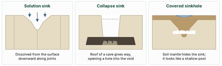
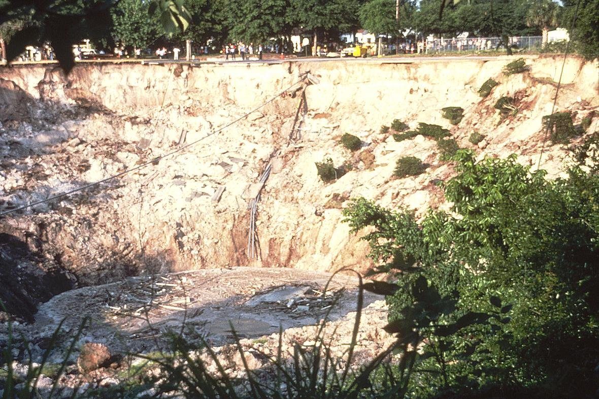
"Sinkholes are very common in limestone/karst areas." NCERT describes a sinkhole as "an opening more or less circular at the top and funnel-shapped towards the bottom with sizes varying in area from a few sq. m to a hectare and with depth from a less than half a metre to thirty metres or more". There are two kinds. Solution sinks form "solely through solution action". Others start as solution forms, but if the bottom of a sinkhole forms the roof of a void or cave underground, it may collapse, "leaving a large hole opening into a cave or a void below": these are collapse sinks. "Solution sinks are more common than collapse sinks." Sinkholes are often covered by a soil mantle and then appear as shallow water pools. The NPS definition combines the two origins: a sinkhole is "a depression or hole formed when the land surface sinks due to underground bedrock dissolution or cave collapse."
Don't confuse: Doline
NCERT: "The term doline is sometimes used to refer the collapse sinks." In international usage, doline is the general name for any closed karst depression, whatever its origin. For an NCERT-based question, doline = collapse sink; elsewhere, read it as sinkhole in general.
Uvalas, lapies and limestone pavements
"When sink holes and dolines join together because of slumping of materials along their margins or due to roof collapse of caves, long, narrow to wide trenches called valley sinks or Uvalas form." Gradually most of the limestone surface is eaten away by these pits and trenches, leaving it "extremely irregular with a maze of points, grooves and ridges or lapies". The ridges form "due to differential solution activity along parallel to sub-parallel joints". In time, NCERT says, "The lapie field may eventually turn into somewhat smooth limestone pavements."
Remember: Other names you may meet
Beyond NCERT, textbooks use three more karst terms, labelled here as standard textbook terms rather than NCERT's: karren, the international name for lapies; ponor, a swallow hole in the sense of a point where a stream sinks; and polje, a large, flat-floored closed depression, larger than an uvala.
Caves and tunnels
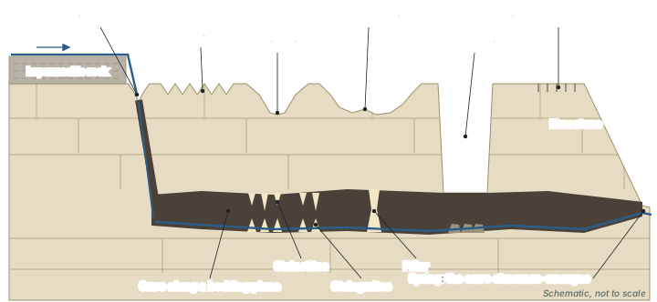
NCERT notes that cave formation is prominent in two settings: where limestones or dolomites alternate with beds of other rocks (shales, sandstones, quartzites), and where limestones are dense, massive and occur as thick beds. Water percolates down through the rock or through cracks and joints and then moves horizontally along bedding planes. "It is along these bedding planes that the limestone dissolves and long and narrow to wide gaps called caves result." There can be a maze of caves at different levels, depending on the limestone beds and the rocks between them. Caves normally have an opening through which cave streams are discharged, and "Caves having openings at both the ends are called tunnels."
The NPS describes the same plumbing from the cave explorer's side: streams inside caves "make passageways and continue to enlarge them", bring in sediment that scours the rock, and "Eventually the stream exits the cave and returns to the surface as a spring." (US National Park Service, "Solution caves")
Depositional landforms: stalactites, stalagmites and pillars
Many depositional forms develop within limestone caves, from the calcium carbonate that water brings in solution (described under the chemistry of solution and deposition, above).
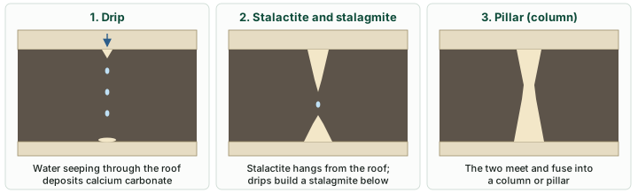
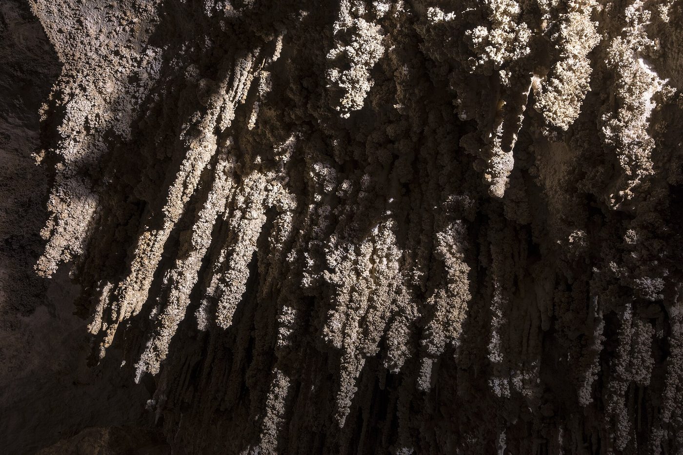
- Stalactites "hang as icicles of different diameters. Normally they are broad at their bases and taper towards the free ends showing up in a variety of forms."
- Stalagmites "rise up from the floor of the caves". They form "due to dripping water from the surface or through the thin pipe, of the stalactite, immediately below it". A stalagmite may take the shape of a column or a disc, with either a smooth, rounded, bulging end or a small crater-like depression.
- Pillars or columns: "The stalagmite and stalactites eventually fuse to give rise to columns and pillars of different diameters." (NCERT)
A memory aid
Stalactite or stalagmite? Stalactites hang tight to the ceiling; stalagmites rise from the ground.
Karst and caves in India
NCERT's India: Physical Environment notes that the Meghalaya plateau is rich in mineral resources including limestone, and that heavy south-west monsoon rain has given it "a highly eroded surface". The plateau holds India's longest known cave. NCERT does not name individual caves; the table below gives a few, each with the body that reported it.
Selected karst areas and caves of India
| Cave or area | State | What is recorded | Reported by |
|---|---|---|---|
| Meghalaya plateau | Meghalaya | Rich in limestone; "a highly eroded surface" | NCERT, India: Physical Environment |
| Krem Liat Prah | Meghalaya (East Jaintia Hills) | India's longest known cave. It took the record in 2006, when it measured 22 km. By March 2018 the connected Krem Liat Prah-Umim-Labit system measured "a little over 31km" (Brian Daly Kharpran, Meghalaya Adventurers' Association). Surveys continue | Bristol Exploration Club, Meghalaya expedition report (2006); Kharpran quoted by The Better India, 20 Mar 2018 |
| Krem Puri | Meghalaya (East Khasi Hills, near Laitsohum) | Reported in 2018 as "the world's largest sandstone cave", 24,583 m long. A sandstone cave, not a limestone one | The Better India, 20 Mar 2018, citing a Hindustan Times report |
| Borra Caves | Andhra Pradesh | Limestone caves; "one of India's deepest", reaching about 80 m | Ministry of Tourism, Incredible India, "Borra Caves" |
| Kotumsar Cave | Chhattisgarh (Kanger Valley, Bastar district) | Karst cave; home to a cave-dwelling fish, formerly identified as Indoreonectes (Nemacheilus) evezardi; its identity is now unsettled (DNA analysis by Keskar and others, 2018, as cited by the database) | Cave fishes database (Proudlove), species record 56 |
Source: NCERT, India: Physical Environment, Class XI, chapter 2 "Structure and Physiography" (Reprint 2026-27); Bristol Exploration Club, Meghalaya expedition report (2006); The Better India, 20 Mar 2018; Ministry of Tourism, Incredible India, "Borra Caves"; Cave fishes database (Proudlove), species record 56. Cave lengths are survey figures that change as exploration continues (as of the sources' dates).
Don't confuse: Cave and karst
Not every cave is karst. Krem Puri is a sandstone cave. Karst topography, in NCERT's definition, belongs to limestone or dolomite regions, where the rock is dissolved.
Summary
- Groundwater works mainly by solution; its landforms appear in limestone and dolomite, as karst topography, named after the Karst region of the Balkans.
- Carbonic acid dissolves calcium carbonate; losing carbon dioxide or evaporating, the water deposits it again.
- Erosional forms: swallow holes (NCERT: shallow solution depressions), sinkholes (solution sinks, more common, and collapse sinks, called dolines in NCERT), uvalas, lapies and limestone pavements.
- Caves form along bedding planes; a cave open at both ends is a tunnel.
- Depositional forms: stalactites hang, stalagmites rise, and the two fuse into pillars.
- About 15.2% of the ice-free land is karstifiable carbonate rock, and 1.18 billion people live on karst (2020). In India, Meghalaya has the longest known cave, Krem Liat Prah.
Karst landforms at a glance
| Landform | Erosional or depositional | How it forms (NCERT) | Size or note |
|---|---|---|---|
| Swallow hole | Erosional | Solution of the limestone surface | Small to medium, shallow, round to sub-rounded |
| Solution sink | Erosional | Solution alone | More common than collapse sinks |
| Collapse sink (doline in NCERT) | Erosional | Roof of a cave or void collapses | Opens into a cave below |
| Sinkhole (general) | Erosional | Solution or collapse | A few m² to a hectare; under 0.5 m to 30 m or more deep |
| Uvala (valley sink) | Erosional | Sinkholes and dolines join by slumping or cave-roof collapse | Long, narrow to wide trench |
| Lapies | Erosional | Differential solution along joints | Maze of points, grooves and ridges |
| Limestone pavement | Erosional | Lapie field smoothed in time | Fairly smooth surface |
| Cave / tunnel | Erosional | Solution along bedding planes | Tunnel: open at both ends |
| Stalactite | Depositional | Calcium carbonate deposited from drips at the roof | Broad base, tapering free end |
| Stalagmite | Depositional | Drips falling to the floor | Column, disc, or crater-like top |
| Pillar / column | Depositional | Stalactite and stalagmite fuse | Different diameters |
Source: NCERT, Fundamentals of Physical Geography, Class XI, chapter 6 "Landforms and their Evolution" (Reprint 2026-27).
Sources
Each table and data figure names its source beneath it. The main documents are collected here, with a date where the source carries one. Figures not listed under image credits were drawn for this page from the sources stated in their source lines.
Main sources
| Topic | Source |
|---|---|
| Textbooks | NCERT, Fundamentals of Physical Geography, Class XI, chapter 6 "Landforms and their Evolution" (Reprint 2026-27); NCERT, India: Physical Environment, Class XI, chapter 2 "Structure and Physiography" (Reprint 2026-27) |
| Groundwater and karst | Goldscheider and others (2020), "Global distribution of carbonate rocks and karst water resources", Hydrogeology Journal 28: 1661-1677; US National Park Service, "Karst landscapes"; US National Park Service, "Solution caves"; US National Park Service, Mammoth Cave National Park FAQ (updated 7 Nov 2024) |
| Caves of India | Bristol Exploration Club, Meghalaya expedition report (2006); The Better India, 20 Mar 2018; Ministry of Tourism, Incredible India, "Borra Caves"; Cave fishes database (Proudlove), species record 56 |
Image credits
| Image | Credit and licence |
|---|---|
| Winter park florida sinkhole 1981 11 USGS | Anthony S. Navoy, USGS, 9 May 1981. Public domain. File page |
| Stalactites under Iceberg Rock - Main Corridor, Carlsbad Cavern | NPS / Daniel Leifheit, Carlsbad Caverns National Park, 29 January 2018. Public domain. File page |
| All other figures | Drawn for this page from the sources given in their source lines. |