 BharatNotes
Part 6 of 9 of the Geomorphology and Landforms notes. The overview page has the quick revision, exam strategy and key terms for all nine parts.
Glaciers
Glaciers are slow, but they erode on a tremendous scale: valley glaciers carve broad U-shaped troughs and cut mountain tops into horns and knife-edge ridges. When the ice melts, it leaves behind ridges and sheets of debris. This part describes how glaciers move and erode, the landforms they carve and build, India's Himalayan glaciers, and the growing glacial lakes that satellites now monitor.
Cross-paper relevance
- GS1 (Geography, primary): glaciers and how they move, erosional and depositional glacial landforms, India's Himalayan glaciers and the rivers they feed
- GS3 (Disaster management): glacial lakes and glacial lake outburst floods (GLOFs), ISRO's satellite monitoring of expanding glacial lakes, the Dharali flash flood of August 2025
What a glacier is
NCERT defines glaciers as "Masses of ice moving as sheets over the land (continental glacier or piedmont glacier if a vast sheet of ice is spread over the plains at the foot of mountains) or as linear flows down the slopes of mountains in broad trough-like valleys (mountain and valley glaciers)". The two broad kinds are therefore continental glaciers (ice sheets) and mountain or valley glaciers, which flow down valleys like rivers of ice.
Glaciers move slowly, "a few centimetres to a few metres a day or even less or more", and "Glaciers move basically because of the force of gravity." Slow as they are, they erode on a large scale. NCERT explains that "Erosion by glaciers is tremendous because of friction caused by sheer weight of the ice." Material plucked from the land, usually large angular blocks and fragments, is dragged along the floors and sides of the valleys and does "great damage through abrasion and plucking". Glaciers can damage even unweathered rock and "can reduce high mountains into low hills and plains". As erosion goes on, the slope is eventually reduced so much that the glacier stops moving, leaving "only a mass of low hills and vast outwash plains along with other depositional features".
Key idea
Two tools of glacial erosion. Plucking: the ice pulls away blocks of rock from the bed and sides. Abrasion: those blocks, dragged along by the ice, scrape and scour the rock beneath. The scratches they leave are glacial striations, which the US National Park Service describes as fine, commonly straight and parallel lines on a bedrock surface, "usually oriented in the direction of ice movement".
Erosional landforms
Cirques and tarns
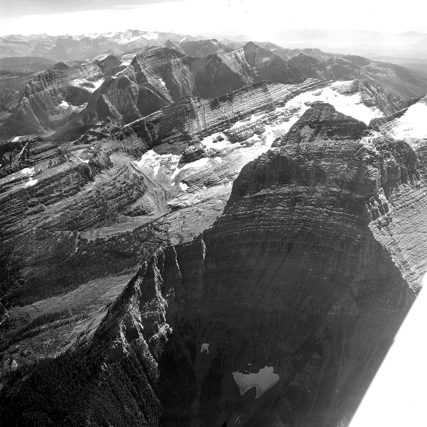
"Cirques are the most common of landforms in glaciated mountains." They are often found at the heads of glacial valleys, where "The accumulated ice cuts these cirques while moving down the mountain tops." NCERT describes them as deep, long and wide troughs or basins "with very steep concave to vertically dropping high walls at its head as well as sides". After the glacier disappears, a lake is often seen inside a cirque: "Such lakes are called cirque or tarn lakes." Two or more cirques may lead one into another down the slope "in a stepped sequence". The NPS glossary's definition is the same landform in brief: "A semicircular, topographic hollow eroded by alpine glaciers; commonly contains a small round lake".
Horns and arêtes
"Horns form through head ward erosion of the cirque walls. If three or more radiating glaciers cut headward until their cirques meet, high, sharp pointed and steep sided peaks called horns form." Between neighbouring cirques, the dividing walls are narrowed by progressive erosion until they "turn into serrated or saw-toothed ridges sometimes referred to as arêtes with very sharp crest and a zig-zag outline". The NPS glossary describes an arête as a ridge that "results from the continued backward growth of the walls of adjoining cirques". NCERT's examples of horns are the Matterhorn in the Alps and Everest: NCERT describes Everest as a horn formed through headward erosion of radiating cirques.
Don't confuse: the Matterhorn is a horn, not the Alps' highest peak
NCERT calls the Matterhorn "The highest peak in the Alps". It is not. Zermatt Tourism gives its height as 4,478 m and states: "It is not the highest summit: the Monte Rosa, almost directly opposite, is higher". Mont Blanc, the highest peak of the Alps, is higher again. The mountain has a Swiss side above Zermatt and an Italian side above Breuil; the Zermatt Tourism history names its Swiss north-east ridge and Italian south-west ridge. Its fame as a horn is deserved; its rank in NCERT's sentence is not.
Glacial valleys, hanging valleys and fjords
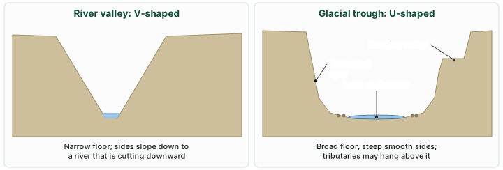
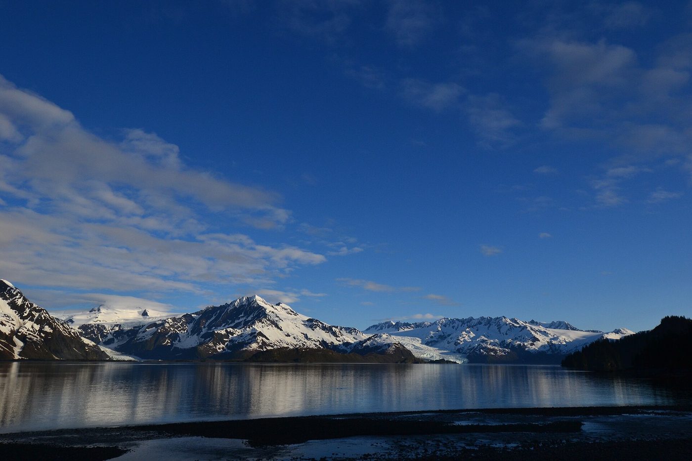
"Glaciated valleys are trough-like and U-shaped with broad floors and relatively smooth, and steep sides." They may contain scattered debris or debris shaped as moraines, and lakes "gouged out of rocky floor or formed by debris within the valleys". Hanging valleys may sit high on one or both sides of the main valley; the NPS glossary defines one as "A tributary glacial valley whose mouth is high above the floor of the main valley, which was eroded by the main body of the glacier." Where hanging valleys open into the main valley, the faces of the spurs between them are often cut back, giving "an appearance like triangular facets". At the coast, "Very deep glacial troughs filled with sea water and making up shorelines (in high latitudes) are called fjords/fiords" (NCERT). The NPS adds that a fjord is "generally several hundred meters deep" and usually the seaward end of a glacial trough "partially submerged by drowning after the melting of glacial ice".
River valley and glacial valley compared
| Feature | River valley | Glacial valley (trough) |
|---|---|---|
| Cross-profile | V-shaped (in youth and maturity) | U-shaped, trough-like |
| Floor | Narrow; little or no floodplain in youth | Broad; may hold debris, moraines and lakes |
| Sides | Slope down to the river | Steep and relatively smooth |
| Hanging valleys | - | May sit high on one or both sides of the main valley |
| Spurs | - | Faces often truncated into triangular facets |
| At the coast | Delta or estuary (see fluvial landforms) | Fjord, if drowned by the sea |
Source: NCERT, Fundamentals of Physical Geography, Class XI, chapter 6 "Landforms and their Evolution" (Reprint 2026-27).
Depositional landforms
Glaciers deposit two kinds of material, and the difference matters for every landform that follows.
Glacial till and outwash
| Glacial till | Outwash deposits | |
|---|---|---|
| Laid down by | Melting ice, directly | Meltwater streams (glacio-fluvial) |
| Sorting | "unassorted coarse and fine debris" | "roughly stratified and assorted" |
| Shape of fragments | Angular to sub-angular | Somewhat rounded at the edges |
| Landforms | Moraines, drumlins | Eskers, outwash plains |
Source: NCERT, Fundamentals of Physical Geography, Class XI, chapter 6 "Landforms and their Evolution" (Reprint 2026-27).
Moraines
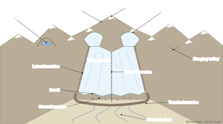
Moraines are "long ridges of deposits of glacial till". The NPS glossary describes a moraine as an accumulation "of unsorted, unstratified glacial drift, predominantly till, deposited mostly by direct action of a glacier". NCERT names four kinds.
The four moraines
| Moraine | Where it lies | What NCERT adds |
|---|---|---|
| Terminal | At the end (toe) of the glacier | Long ridges of debris; laterals may join it in a horseshoe-shaped ridge |
| Lateral | Along the sides, parallel to the valley | There can be many on either side; they "partly or fully owe their origin to glacio-fluvial waters pushing up materials to the sides of glaciers" |
| Medial | In the centre of the valley, flanked by laterals | "imperfectly formed as compared to lateral moraines"; sometimes indistinguishable from ground moraines |
| Ground | An irregular sheet of till over the valley floor | Left by valley glaciers "retreating rapidly"; varies greatly in thickness and surface form |
Source: NCERT, Fundamentals of Physical Geography, Class XI, chapter 6 "Landforms and their Evolution" (Reprint 2026-27); US National Park Service, Glossary of Geologic Terms.
Eskers
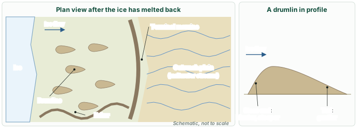
In summer, meltwater flows over the ice, seeps down its margins or moves through holes in it, and collects beneath the glacier to flow like a stream in a channel under the ice. "Such streams flow over the ground (not in a valley cut in the ground) with ice forming its banks." The coarse material such a stream carries, "boulders and blocks along with some minor fractions of rock debris", settles in its channel beneath the glacier, and "after the ice melts can be found as a sinuous ridge called esker" (NCERT).
Outwash plains
The plains at the foot of glacial mountains, or beyond the limits of continental ice sheets, are covered with glacio-fluvial deposits "in the form of broad flat alluvial fans which may join to form outwash plains of gravel, silt, sand and clay" (NCERT). The NPS glossary's definition matches: a "broad, gently sloping sheet of outwash deposited by meltwater streams flowing from the front of or beyond a glacier, and formed by coalescing outwash fans".
Drumlins
"Drumlins are smooth oval shaped ridge-like features composed mainly of glacial till with some masses of gravel and sand." Their long axes lie parallel to the direction of ice movement, and they "may measure up to 1 km in length and 30 m or so in height". The end facing the glacier, the stoss end, "is blunter and steeper than the other end called tail". NCERT explains that drumlins form "due to dumping of rock debris beneath heavily loaded ice through fissures in the glacier", and that the stoss end is blunted by the push of the moving ice. Because of their alignment, "Drumlins give an indication of direction of glacier movement."
Kame, erratic and roche moutonnée
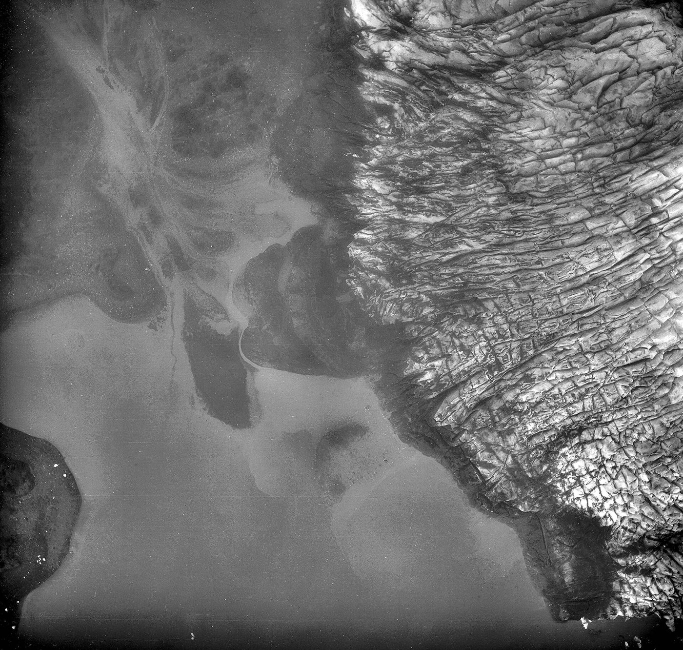
Beyond NCERT. Three more depositional terms appear in other textbooks; the definitions here are the US National Park Service's. A kame is "A mound, knob, or short irregular ridge, composed of stratified sand and gravel deposited by a subglacial stream as a fan or delta at the margin of a melting glacier." An erratic is "A rock fragment carried by glacial ice deposited at some distance from the outcrop from which it was derived". A roche moutonnée is "A glacially sculpted, elongated bedrock knob or hillock"; in the standard textbook description it is smoothed on the up-glacier side by abrasion and steep and jagged on the down-glacier side, where the ice plucked it.
India's glaciers
"We have many glaciers in our country moving down the slopes and valleys in Himalayas," NCERT notes, and the higher reaches of Uttarakhand (NCERT still uses the old name Uttaranchal), Himachal Pradesh and Jammu and Kashmir are places to see some of them. Several great rivers begin at glaciers:
- Ganga. The Ganga "rises in the Gangotri glacier near Gaumukh (3,900 m) in the Uttarkashi district of Uttarakhand. Here, it is known as the Bhagirathi." It meets the Alaknanda at Devprayag, and below that confluence it is known as the Ganga (NCERT, India: Physical Environment).
- Alaknanda. The two NCERT books name different glaciers. Fundamentals of Physical Geography: "Alkapuri glacier feeds waters to Alakananda river." India: Physical Environment: "The Alaknanda has its source in the Satopanth glacier above Badrinath."
- Brahmaputra. It originates in the Chemayungdung glacier of the Kailash range near the Mansarovar lake (NCERT, India: Physical Environment).
- Siachen and Baltoro. NCERT's India: Physical Environment (2019 reprint) names "the Baltoro and Siachen" among the important glaciers of South Asia in the Kashmir Himalayas. NASA's Earth Observatory describes Siachen as "the second-longest glacier within Earth's midlatitudes", 75 km long (17 March 2024).
Glacial lakes and outburst floods
As glaciers retreat, new lakes form and old ones grow. ISRO calls these "glacial lakes" and notes that they are freshwater sources for Himalayan rivers but also a hazard. "GLOFs occur when glacial lakes release large volumes of meltwater due to the failure of natural dams, such as those made of moraine or ice, resulting in sudden and severe flooding downstream." Such failures, ISRO adds, can be triggered by "avalanches of ice or rock, extreme weather events, and other environmental factors". The moraines described above are thus more than landforms: many glacial lakes are dammed by them.
In April 2024 ISRO published an analysis of satellite imagery from 1984 to 2023 covering the catchments of the Indian Himalayan river basins, an area that extends well beyond India's borders. "Of the 2,431 lakes larger than 10 hectares identified during 2016-17, 676 glacial lakes have notably expanded since 1984." Of these 676, 130 lie within India: 65 in the Indus basin, 7 in the Ganga basin and 58 in the Brahmaputra basin. ISRO adds: "Elevation-based analysis reveals that 314 lakes are located in the 4,000 to 5,000 m range and 296 lakes are above 5,000 m elevation." One example is the Ghepang Ghat glacial lake in Himachal Pradesh (Indus basin, 4,068 m), which grew by 178%, from 36.49 to 101.30 hectares, between 1989 and 2022.
Expanding glacial lakes in numbers
- 676 of 2,431 glacial lakes over 10 ha (2016-17 inventory) expanded notably since 1984 (ISRO, Apr 2024).
- 601 (89%) of those 676 more than doubled in size; 10 grew 1.5 to 2 times and 65 grew 1.5 times.
- 130 of the expanding lakes lie in India: Indus 65, Ganga 7, Brahmaputra 58.
The 676 expanding glacial lakes by type (ISRO, April 2024)
| Type (by how the water is held) | Number of expanding lakes |
|---|---|
| Moraine-dammed (water dammed by moraine) | 307 |
| Erosion (water held in depressions formed by erosion) | 265 |
| Other glacial lakes | 96 |
| Ice-dammed (water dammed by ice) | 8 |
| Total | 676 |
Source: ISRO, "Satellite insights: expanding glacial lakes in the Indian Himalayas" (April 2024). The total is ISRO's; the four counts add up to it.
A different inventory gives a much larger number because it counts much smaller lakes. The National Remote Sensing Centre's inventory for the National Hydrology Project (December 2023) lists 28,043 glacial lakes of 0.25 hectare or more in the Indian Himalayan Region. The two figures answer different questions (all lakes above 0.25 ha within the Indian Himalayan Region, against lakes above 10 ha across whole river catchments), so they should never be compared directly.
Dharali, Uttarakhand, August 2025
On 5 August 2025 a flash flood sent debris-laden flows over Dharali and Harsil villages in Uttarkashi district, Uttarakhand, sweeping away homes, buildings, bridges and roads and claiming lives. ISRO's National Remote Sensing Centre compared Cartosat-2S images taken after the event (7 August 2025) with earlier ones. Its release described "A catastrophic flash flood triggered by intense rainfall" and stated that "Scientific analysis is being carried out to ascertain the cause of the triggering event." Whether a cloudburst, or the failure of a glacial or landslide dam upstream, set off the flood was not settled in that release.
Sources for this section: ISRO, "Satellite insights: expanding glacial lakes in the Indian Himalayas" (April 2024); NRSC, National Hydrology Project glacial lake inventory (Dec 2023); ISRO/NRSC, "Indian satellite data based analysis of the Dharali flash flood" (7 Aug 2025).
Summary
- Glaciers are continental (ice sheets, piedmont glaciers) or mountain and valley glaciers; they move by gravity, a few centimetres to a few metres a day.
- They erode by plucking and abrasion, leaving striations, and can reduce mountains to low hills and outwash plains.
- Erosional forms: cirques (often with tarns), horns, arêtes, U-shaped troughs, hanging valleys with truncated spurs, and fjords. NCERT calls the Matterhorn the Alps' highest peak; it is not.
- Till is unsorted and angular; outwash is roughly stratified and rounded. Moraines (terminal, lateral, medial, ground) and drumlins are till; eskers and outwash plains are outwash.
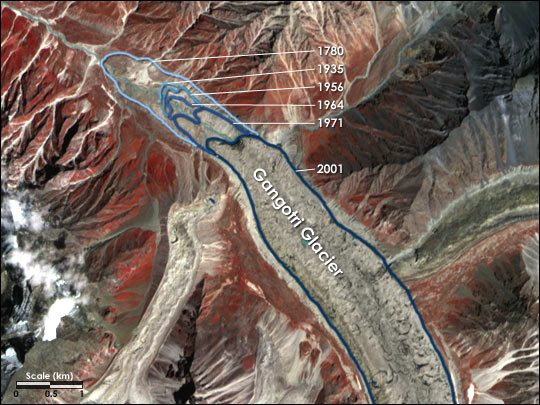
- India's glaciers feed the Ganga (Gangotri, at Gaumukh), the Alaknanda and the Brahmaputra; Siachen is 75 km long (NASA, 2024). Gangotri has been receding since 1780 (NASA).
- ISRO (April 2024): 676 of 2,431 glacial lakes over 10 ha have grown since 1984, 130 of them in India. Moraine-dammed lakes are the commonest type, and dam failure causes GLOFs.
Glacial landforms at a glance
| Landform | Erosional or depositional | How it forms | Key feature |
|---|---|---|---|
| Cirque | Erosional | Ice cuts a basin at the valley head | Steep concave walls; may hold a tarn |
| Horn | Erosional | Three or more cirques cut headward until they meet | Sharp, steep-sided peak |
| Arête | Erosional | Walls between cirques narrowed | Saw-toothed ridge, zig-zag outline |
| U-shaped valley | Erosional | Erosion by a valley glacier | Broad floor, steep smooth sides |
| Hanging valley | Erosional | Main glacier erodes the main valley floor far below a tributary's mouth | Mouth high above the main floor |
| Fjord | Erosional | Deep glacial trough drowned by the sea | High-latitude coasts |
| Moraine | Depositional (till) | Debris dropped directly by ice | Terminal, lateral, medial, ground |
| Drumlin | Depositional (till) | Debris dumped beneath heavily loaded ice | Up to 1 km long, 30 m high; stoss and tail |
| Esker | Depositional (outwash) | Stream channel beneath the ice fills with coarse debris | Sinuous ridge |
| Outwash plain | Depositional (outwash) | Meltwater fans join beyond the ice | Gravel, silt, sand and clay |
Source: NCERT, Fundamentals of Physical Geography, Class XI, chapter 6 "Landforms and their Evolution" (Reprint 2026-27); US National Park Service, Glossary of Geologic Terms.
Sources
Each table and figure names its source beneath it. The main documents are collected here, with a date where the source carries one. Figures not listed under image credits were drawn for this page from the sources stated in their source lines.
Main sources
| Topic | Source |
|---|---|
| Textbooks | NCERT, Fundamentals of Physical Geography, Class XI, chapter 6 "Landforms and their Evolution" (Reprint 2026-27); NCERT, India: Physical Environment, Class XI (the Siachen and Baltoro line quoted from the 2019 reprint) |
| Glacial terms (striations, cirque, arête, hanging valley, fjord, moraine, outwash plain, kame, erratic, roche moutonnée) | US National Park Service, Glossary of Geologic Terms |
| The Matterhorn | Zermatt Tourism, "Matterhorn" |
| Siachen | NASA Earth Observatory, "Siachen Glacier" (Image of the Day, 17 Mar 2024) |
| Gangotri | NASA Earth Observatory, "Retreat of the Gangotri Glacier" (Image of the Day, 23 Jun 2004) |
| Glacial lakes and GLOFs | ISRO, "Satellite insights: expanding glacial lakes in the Indian Himalayas" (April 2024); NRSC, National Hydrology Project glacial lake inventory (Dec 2023) |
| Dharali flash flood | ISRO/NRSC, "Indian satellite data based analysis of the Dharali flash flood" (7 Aug 2025) |
Image credits
| Image | Credit and licence |
|---|---|
| Agassiz Glacier, Cirque Glacier Remnant, September 8, 1969 (GLACIERS 1629) | Austin Post, 8 September 1969. Public domain. File page |
| Pederson and Aialik Glaciers | National Park Service, Alaska Region, 5 June 2013. Public domain. File page |
| Columbia Glacier, Terminus and Terminal Moraine, Heather Island, August 24, 1968 (GLACIERS 998) | Austin Post, 24 August 1968. Public domain. File page |
| Kukak Glacier, terminus of valley glacier and braided streams, August 26, 1969 (GLACIERS 7019) | Austin Post, 26 August 1969. Public domain. File page |
| Gangotri Glacier, retreat from 1780 to 2001 | NASA Earth Observatory. Public domain. File page |
| All other figures | Drawn for this page from the sources given in their source lines. |