 BharatNotes
Part 4 of 9 of the Geomorphology and Landforms notes. The overview page has the quick revision, exam strategy and key terms for all nine parts.
Running Water
Of all the agents that shape the land, running water does the most work in humid regions. This part follows a river from its headwaters to the sea: how a landscape changes as its rivers age, the valleys, gorges and waterfalls that rivers cut, and the fans, floodplains, levees, meanders and deltas they build. It ends with India's rivers, which offer an example of almost every form.
Running water as an agent
NCERT puts it plainly: "In humid regions, which receive heavy rainfall running water is considered the most important of the geomorphic agents in bringing about the degradation of the land surface." Running water works in two ways. Overland flow moves as a thin sheet over the general land surface, and linear flow is concentrated in streams and rivers in their valleys.
Overland flow causes sheet erosion. Where the surface is uneven, the sheet gathers into narrow paths, and the friction of the moving water removes material along them. Small, narrow rills form; rills grow into long, wide gullies; and gullies deepen, widen, lengthen and join until they form a network of valleys. A drainage network is therefore built from the top down, one channel at a time.
Most erosional landforms of running water belong to vigorous rivers on steep gradients. As erosion lowers a channel's gradient, the river loses velocity and begins to deposit. Some deposition happens even on steep slopes, but it is small compared with what happens on medium to gentle slopes: in NCERT's words, "The gentler the river channels in gradient or slope, the greater is the deposition." As down-cutting slows, rivers erode their banks sideways, and hills and valleys are gradually reduced towards plains.
Key idea
If erosion runs long enough, valley sides are lowered, divides between basins are flattened, and what is left is "a lowland of faint relief with some low resistant remnants called monadnocks". NCERT calls this end-form a peneplain ("an almost plain"). The part on landform development theories sets out the theory behind it, W.M. Davis's cycle of erosion, and the criticisms of that theory.
Youth, maturity and old age
NCERT describes the landscape of a river region in three stages. The stages describe the whole landscape (its streams, valleys and divides), not only the river channel, and they are a way of organising what one sees rather than a timetable: a single river can show youthful features near its source and old-age features near its mouth.
- Youth. Streams are few and poorly integrated, and they flow over the original slopes in shallow V-shaped valleys with no floodplains, or very narrow ones along the trunk streams. The divides between streams are broad and flat, with marshes, swamps and lakes. Any meanders form on these broad upland surfaces and may later entrench themselves into the uplands. Waterfalls and rapids may exist where local bodies of hard rock are exposed.
- Maturity. Streams are plentiful and well integrated. Valleys are still V-shaped but deep. Trunk streams are broad enough to have wider floodplains, within which they may meander, though the meanders stay confined within the valley. The flat interstream areas, swamps and marshes of youth disappear, the divides turn sharp, and the waterfalls and rapids disappear.
- Old age. Smaller tributaries are few, with gentle gradients. Streams meander freely over vast floodplains with natural levees and oxbow lakes. Divides are again broad and flat, with lakes, swamps and marshes, and most of the landscape is at or slightly above sea level.
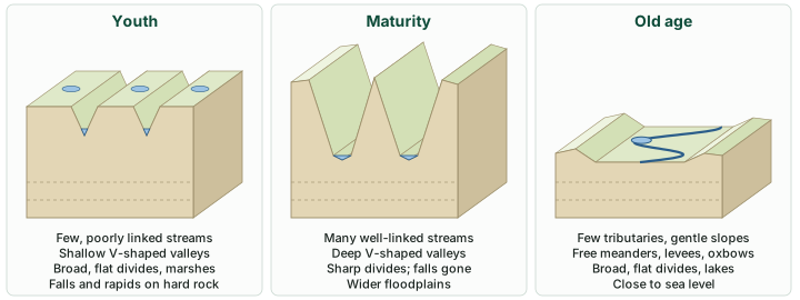
The three stages compared
| Feature | Youth | Maturity | Old age |
|---|---|---|---|
| Streams | Few, poorly integrated | Plentiful, well integrated | Few small tributaries, gentle gradients |
| Valleys | Shallow, V-shaped | V-shaped but deep | Broad, with vast floodplains |
| Floodplains | None, or very narrow along trunk streams | Wider, along trunk streams | Vast |
| Divides | Broad and flat, with marshes, swamps and lakes | Sharp | Broad and flat, with lakes, swamps and marshes |
| Meanders | May form on uplands and entrench | Confined within the valley | Free, with levees and oxbow lakes |
| Waterfalls and rapids | Where hard rock is exposed | Disappear | Absent |
| Height | Upland | Valleys cut deep | At or slightly above sea level |
Source: NCERT, Fundamentals of Physical Geography, Class XI, chapter 6 "Landforms and their Evolution" (Reprint 2026-27).
Erosional landforms
Valleys, gorges and canyons
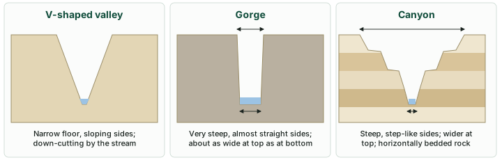
Valleys begin as small, narrow rills, which grow into long, wide gullies and then into valleys. Depending on their size and shape, NCERT names several kinds: the V-shaped valley, the gorge and the canyon. A V-shaped valley is the typical form where a river is cutting down faster than its sides are worn back. In India, the Bhagirathi cuts "through the Central and the Lesser Himalayas in narrow gorges" before it meets the Alaknanda at Devprayag to form the Ganga (NCERT, India: Physical Environment).
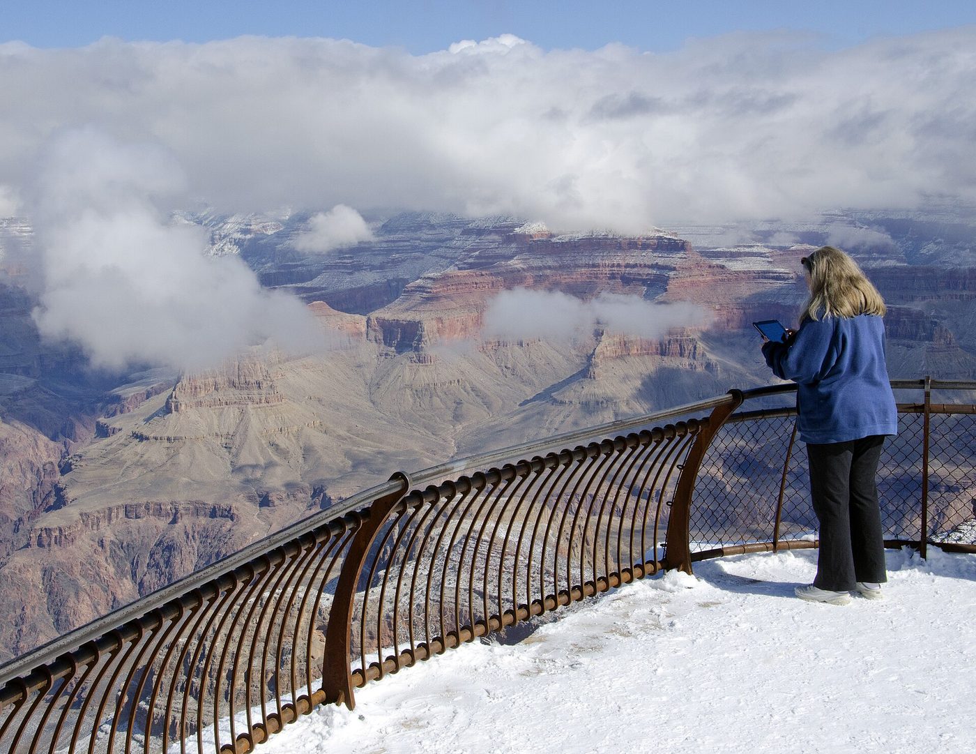
A gorge is a deep valley with very steep to straight sides. A canyon has steep, step-like side slopes and may be as deep as a gorge. The difference lies in the cross-profile: "A gorge is almost equal in width at its top as well as its bottom. In contrast, a canyon is wider at its top than at its bottom. In fact, a canyon is a variant of gorge." Rock type matters too: "canyons commonly form in horizontal bedded sedimentary rocks and gorges form in hard rocks" (NCERT). NCERT's Indian gorge is the Kaveri near Hogenekal in Dharmapuri district, Tamil Nadu. The Indus, NCERT notes, cuts across the Ladakh range, "forming a spectacular gorge near Gilgit".
Waterfalls, potholes and plunge pools
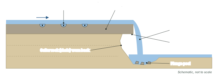
A waterfall forms where a river drops over a steep step in its bed, typically where a band of resistant rock lies over weaker rock. Niagara Falls on the USA-Canada border is the textbook example of such a caprock waterfall: a hard layer of Lockport dolostone sits over softer shale. In the usual explanation the softer rock is worn back beneath the caprock until the unsupported ledge collapses, so the fall retreats upstream. In India, Jog Falls in Karnataka is formed by the Sharavathi river "plunging from a sheer cliff 253 metres (830 feet)" in four cascades known as Raja, Roarer, Rocket and Rani (Karnataka Tourism).
On the rocky beds of hill streams, the current swirls pebbles and boulders round and round. NCERT: "Over the rocky beds of hill-streams more or less circular depressions called potholes form because of stream erosion aided by the abrasion of rock fragments." Once a depression forms, the trapped fragments keep rotating in it and the hole grows: "A series of such depressions eventually join and the stream valley gets deepened." At the foot of a waterfall the same work is done on a larger scale, "because of the sheer impact of water and rotation of boulders": "Such large and deep holes at the base of waterfalls are called plunge pools."
Incised or entrenched meanders
On steep gradients a stream's erosion is concentrated on the bottom of its channel, and it cuts little sideways; on gentle slopes active lateral erosion gives it a sinuous, meandering course. "But very deep and wide meanders can also be found cut in hard rocks. Such meanders are called incised or entrenched meanders" (NCERT). NCERT's youth stage hints at their origin: meanders on broad upland surfaces "may eventually entrench themselves into the uplands". Its photograph is an entrenched meander loop of the Colorado River in the USA, with the step-like sides of a canyon. The US National Park Service glossary defines an incised meander as one "carved downward into the surface of the valley in which the meander originally formed", and links it to rejuvenation of the river "as a result of rapid vertical uplift or a lowering of base level". NASA's Earth Observatory calls the Goosenecks of the San Juan River in Utah, USA, "one of the best examples of an entrenched river meander in the world", with canyon walls "more than 1,000 feet high" (NASA Earth Observatory, "Goosenecks State Park, Utah").
River terraces
River terraces "are surfaces marking old valley floor or floodplain levels". They may be bare bedrock or alluvial terraces made of stream deposits. Though they may be covered in alluvium, terraces "are basically products of erosion as they result due to vertical erosion by the stream into its own depositional floodplain" (NCERT). A river that cuts down several times leaves a flight of terraces at different heights, each a former river-bed level. When terraces occur at the same height on both sides of a river they are called paired terraces.
Don't confuse: Gorge and canyon; pothole and plunge pool
Gorge vs canyon. Both are deep; a gorge is about as wide at the top as at the bottom and forms in hard rock, while a canyon is wider at the top, has step-like sides and forms in horizontally bedded sedimentary rock.
Pothole vs plunge pool. Both are scoured hollows; potholes are small and lie on rocky stream beds, plunge pools are large and deep and lie at the foot of waterfalls.
Depositional landforms
Alluvial fans
Alluvial fans "are formed when streams flowing from higher levels break into foot slope plains of low gradient" (NCERT). The very coarse load carried down the mountain slopes becomes too heavy for the stream on the gentler gradient, and it is dumped and spread as a broad, low to high cone: the alluvial fan. Streams on fans are usually not confined to their original channels for long; they shift across the fan, forming many channels called distributaries. NCERT notes a climatic contrast: "Alluvial fans in humid areas show normally low cones with gentle slope from head to toe and they appear as high cones with steep slope in arid and semi-arid climates." Its photograph shows an alluvial fan on the route to Amarnath in Jammu and Kashmir. The US National Park Service adds that a fan forms "where a stream issues from a canyon onto a plain or broad valley floor".
In India, fan deposits line the foot of the Himalaya. NCERT describes a narrow belt, the Bhabar, 8 to 10 km wide, parallel to the Shiwalik foothills at the break of slope, where streams from the mountains "deposit heavy materials of rocks and boulders, and at times, disappear in this zone". South of it lies the Tarai, 10 to 20 km wide, where most streams "re-emerge without having any properly demarcated channel", creating marshy and swampy conditions. Farther east, the Kosi river of north Bihar has built a megafan with the three-dimensional geometry of an alluvial fan "but with much gentler gradient (0.05°–0.01°) and with larger area (>10,000 km²)" (Chakraborty and others, 2010).
Open question: Did the Kosi march west?
The Kosi, which NCERT calls the "sorrow of Bihar" and describes as "notorious for frequently changing its course", was long said to have swung more than 113 km westward across its megafan over the last two centuries. The 2010 study of old maps (1760 to 1960), channel deposits and satellite images questions that idea: it found the movement oscillating rather than one-way, and concluded that the river relocated "through random nodal avulsion rather than systematic unidirectional shift". An avulsion is an abrupt switch of a channel to a new course. The authors call for further study and dating before the pattern is settled.
Floodplains, natural levees and point bars
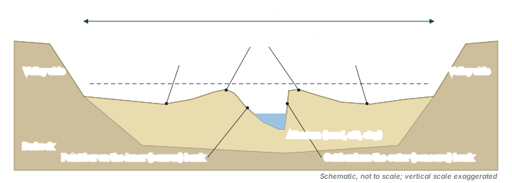
"Deposition develops a floodplain just as erosion makes valleys" (NCERT). Large materials are dropped first where a channel breaks on to a gentle slope; finer sand, silt and clay are carried by slower water in the plains and deposited on the bed, and over the land beyond the banks when the river floods. A river bed made of river deposits is the active floodplain; the floodplain above the banks is the inactive floodplain. The inactive floodplain holds two kinds of deposit: coarse channel deposits, where abandoned or cut-off channels have filled up, and finer flood deposits of silt and clay from spilled water. In a delta, the floodplain is called a delta plain.
Natural levees "are found along the banks of large rivers. They are low, linear and parallel ridges of coarse deposits along the banks of rivers, quite often cut into individual mounds" (NCERT). The NPS glossary explains how they grow: a levee is "A long broad low embankment of sand and coarse silt built by floodwater overflow along both banks of a stream channel."
Point bars, also called meander bars, are sheets of sediment laid down on the inner bank of a meander, the side where the current is slow. NCERT describes them as "sediments deposited in a linear fashion by flowing waters along the bank", "almost uniform in profile and in width" and containing "mixed sizes of sediments". (NCERT's text places point bars on the "concave side" of meanders, but its own account of meanders puts deposition on the convex bank; the convex, inner bank is where they lie.)
Meanders and oxbow lakes
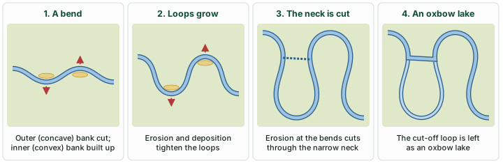
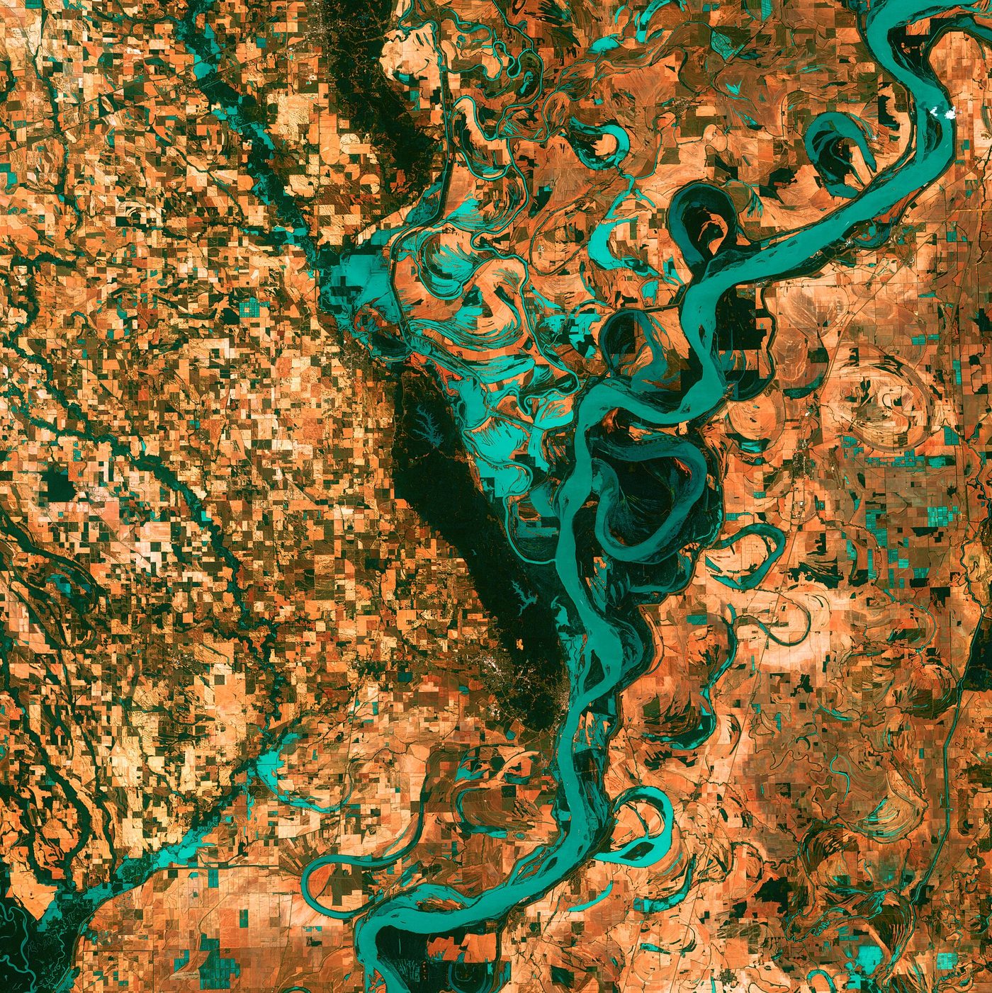
On large floodplains and delta plains, rivers rarely flow in straight courses. Loop-like channel patterns called meanders develop. NCERT stresses a point students often miss: "Meander is not a landform but is only a type of channel pattern." It gives three reasons why rivers meander on gentle gradients: (i) water flowing over very gentle gradients tends to work sideways on its banks; (ii) the banks are made of unconsolidated alluvium with many irregularities that the water can push against; and (iii) in NCERT's wording, the "coriolis force acting on the fluid water deflecting it like it deflects the wind".
Once a bend starts, it feeds itself. The current swings to the outside of the bend and undercuts it, while on the inside it slows and drops sediment: "in meanders of large rivers, there is active deposition along the convex bank and undercutting along the concave bank. The concave bank is known as cut-off bank", which shows up as a steep scarp, while the convex bank has a long, gentle slope. As the loops grow, the neck of land between two bends narrows: "As meanders grow into deep loops, the same may get cut-off due to erosion at the inflection points and are left as ox-bow lakes." The abandoned loop is an oxbow lake. NCERT's satellite scene of the Burhi Gandak near Muzaffarpur, Bihar, shows several oxbow lakes and cut-offs.
Braided channels
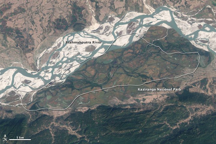
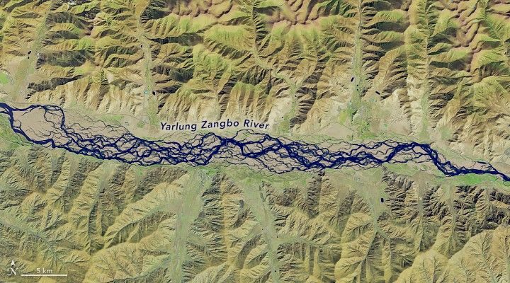
A braided channel splits into many interlacing threads around bars and islands of the river's own deposits. NCERT lists braided channels among the depositional features of the Himalayan rivers in the plains, and notes that "The Brahmaputra plains are known for their riverine islands and sand bars". Braided channels are not confined to plains: the image below shows a river in Tibet braiding across a broad mountain valley floor.
Deltas
Where a river reaches the sea, its load is spread out along the coast. If it is not carried far out to sea or along the shore, it builds a low cone of deposits: a delta. NCERT contrasts deltas with fans: "Unlike in alluvial fans, the deposits making up deltas are very well sorted with clear stratification." The coarsest materials settle out first, and the finer silts and clays are carried out into the sea. As the delta grows, the river's distributaries keep lengthening and the delta keeps building into the sea. NCERT's example is the Krishna delta in Andhra Pradesh. The NPS glossary's definition adds the condition for a delta to survive: sediment supplied "in such quantities that it is not removed by tides, waves, and currents".
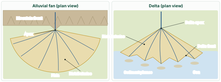
Deltas are classified in two ways, and both appear in textbooks.
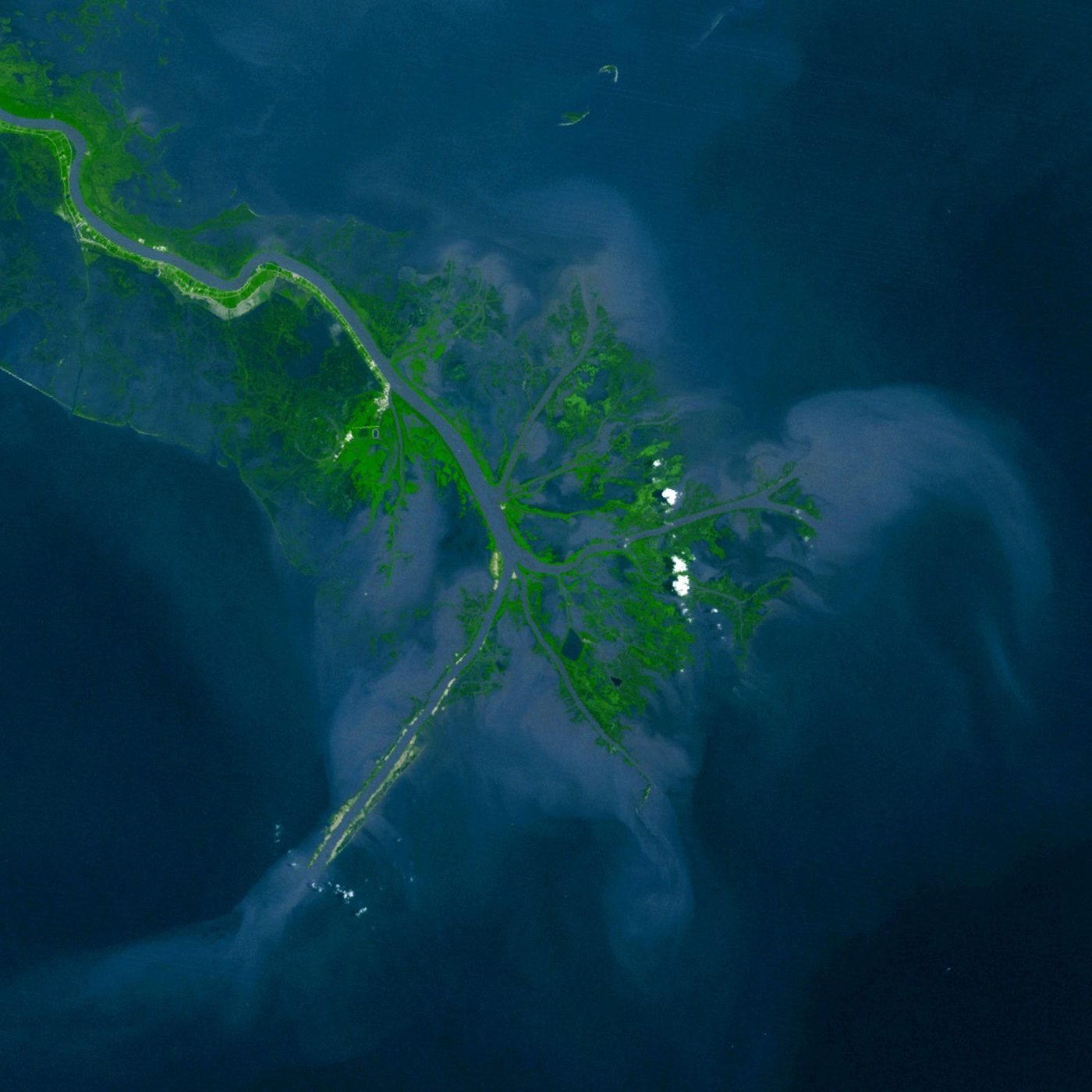
- The traditional shape scheme names deltas by their outline: arcuate (a broad, rounded fan like a bow), bird's foot (long distributaries reaching out like the toes of a bird), cuspate (a pointed, tooth-like delta) and estuarine (built inside a drowned river mouth). The Mississippi is the standard bird's-foot delta.
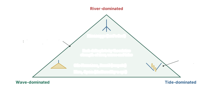
- The process scheme of William Galloway (1975) classifies a delta by what controls it: the river, the waves or the tides. A river-dominated delta, built where waves and tides are weak, "can grow out into a bird foot type of delta" (the Mississippi; the more northern Kilia lobe of the Danube). Wave-dominated deltas have smooth shorelines with beaches and dunes and few distributaries; "The general shape is symmetrically cuspate", as in the São Francisco delta of Brazil, while a strong longshore current can instead build a spit that shelters the delta plain (the Ebro, Spain). Tide-dominated deltas, such as that of the Fly in Papua New Guinea, "resemble estuaries because of their embayed setting of salt marshes, swamps, and tidal flats" (Bosboom and Stive).
The two schemes fit together: the shape is often the visible result of the process. The process scheme explains why a bird's-foot form needs a sheltered sea, and why a cuspate form points to strong waves.
Two ways to classify deltas
| Scheme | Basis | Classes | Examples given in the source |
|---|---|---|---|
| Traditional shape scheme | Outline of the delta | Arcuate, bird's foot, cuspate, estuarine | Mississippi = bird's foot; other textbook examples vary |
| Galloway (1975) | Which process controls it | River-dominated, wave-dominated, tide-dominated | River: Mississippi, Danube (north). Wave: São Francisco (cuspate), Ebro (spit). Tide: Fly |
The Ganga-Brahmaputra-Meghna delta
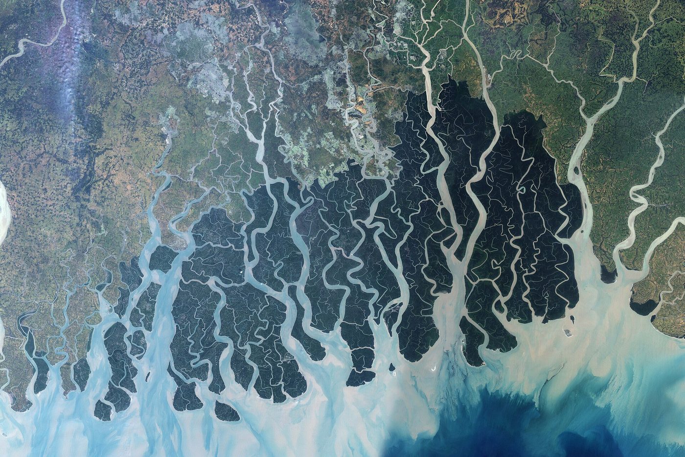
NASA's Earth Observatory states that "The combined delta of the Ganges and Brahmaputra Rivers is the largest in the world" (2001), and a 2021 review in Nature Reviews Earth & Environment calls the Ganges-Brahmaputra-Meghna (GBM) delta "the Earth's largest and most populous delta system" (Paszkowski and others). NCERT's India: Physical Environment names "the famous Sunderbans delta" among "some of the largest deltas of the world". The GBM delta does not fit neatly into one class: a 2015 review finds it "best characterized as a composite system", with parts that behave like an upland fluvial fan delta, a lowland backwater-reach delta, a downdrift tidal delta plain and an offshore subaqueous clinoform (Wilson and Goodbred). It is held together, the same review says, by the "efficient, widespread dispersal of sediment by the large monsoon discharge and high-energy tides".
Estuaries
Not every river builds a delta. An estuary is "The seaward end or tidal mouth of a river where freshwater and seawater mix" (NPS glossary). In India, NCERT says the Narmada and the Tapi "flow in trough faults and fill the original cracks with their detritus materials. Hence, there is a lack of alluvial and deltaic deposits in these rivers." The Narmada "meets the Arabian sea south of Bharuch, forming a broad 27 km long estuary". That estuary is macro-tidal, "with a mean tidal range of 5.67 m (at Dahej Bandar)" (Mahapatra, Ramakrishnan and Rajawat, Journal of Geomatics 8(1), April 2014).
India's rivers and their landforms
NCERT's India: Physical Environment traces most of the forms described above on Indian rivers. The Himalayan rivers "pass through the giant gorges carved out by the erosional activity carried on simultaneously with the uplift of the Himalayas", and also form V-shaped valleys. On entering the plains they build flat valleys, oxbow lakes, floodplains, braided channels and deltas near their mouths, and they meander strongly and shift their courses frequently. The Peninsular rivers differ: they have fixed courses, an absence of meanders and non-perennial flow, the Narmada and the Tapi, which flow through rift valleys, being the exceptions.
The Northern Plains are the great depositional landform of the Himalayan rivers: about 3,200 km from east to west, 150 to 300 km wide on average, with alluvium 1,000 to 2,000 m deep at its thickest (NCERT textbook figures). From north to south NCERT divides them into the Bhabar, the Tarai and the alluvial plains, which are made of older alluvium (bhangar) and newer alluvium (khadar). The alluvial plains show mature-stage forms: sand bars, meanders, oxbow lakes and braided channels.
India's deltas and estuaries in NCERT
| River | Mouth | Landform | What NCERT says |
|---|---|---|---|
| Ganga-Brahmaputra | Bay of Bengal | Delta | "the famous Sunderbans delta" among "some of the largest deltas of the world" |
| Mahanadi | Bay of Bengal | Delta | One of the east-flowing rivers with a well-developed delta |
| Godavari | Bay of Bengal | Delta | Gorge at Polavaram; below Rajamundri it splits into several branches forming a large delta |
| Krishna | Bay of Bengal | Delta | NCERT's textbook example of a delta (Andhra Pradesh) |
| Kaveri | Bay of Bengal | Delta | One of the east-flowing rivers with a well-developed delta |
| Narmada | Arabian Sea | Estuary | Flows in a rift valley; "a broad 27 km long estuary" south of Bharuch |
| Tapi | Arabian Sea | No delta | Flows in a rift valley (trough fault); "a lack of alluvial and deltaic deposits" |
| Rivers of the western coastal plain | Arabian Sea | No deltas | They "do not form any delta"; the Malabar coast has kayals (backwaters) |
Source: NCERT, India: Physical Environment, Class XI, chapter 2 "Structure and Physiography" (Reprint 2026-27); NCERT, India: Physical Environment, Class XI, chapter 3 "Drainage System" (Reprint 2026-27); Krishna delta: NCERT, Fundamentals of Physical Geography, Class XI, chapter 6 "Landforms and their Evolution" (Reprint 2026-27).
Remember
The eastern coastal plain is "an example of an emergent coast" with well-developed deltas; the rivers of the western coastal plain form no deltas. The Narmada and the Tapi flow in trough faults and have no deltas; NCERT describes the Narmada's mouth as "a broad 27 km long estuary".
Summary
- Running water is the leading geomorphic agent in humid regions. Overland flow causes sheet erosion; rills grow into gullies and gullies into valleys.
- NCERT describes youth, maturity and old age of a river landscape. Long erosion ends in a peneplain with monadnocks (theory in landform development theories).
- Erosional forms: V-shaped valleys, gorges (equal width top and bottom, hard rock), canyons (wider at the top, bedded rock), waterfalls, potholes, plunge pools, incised meanders and river terraces.
- Depositional forms: alluvial fans (poorly sorted), floodplains, natural levees, point bars, meanders (a channel pattern, not a landform), oxbow lakes, braided channels and deltas (well sorted, layered).
- Deltas are classified by shape (arcuate, bird's foot, cuspate, estuarine) or, after Galloway (1975), by river, wave or tide dominance. The GBM delta is the world's largest (NASA; 2021 review) and a composite system.
- East-coast rivers build deltas; the Narmada and the Tapi flow in trough faults and build no deltas; the Narmada ends in a 27 km estuary.
Landforms of running water at a glance
| Landform | Erosional or depositional | How it forms | Example (source) |
|---|---|---|---|
| V-shaped valley | Erosional | Down-cutting faster than the sides are worn back | Bhagirathi gorges above Devprayag (NCERT) |
| Gorge | Erosional | Deep cutting in hard rock; sides near vertical | Kaveri near Hogenekal, Tamil Nadu (NCERT) |
| Canyon | Erosional | Deep cutting in horizontally bedded rock; stepped sides | Colorado River, USA (NCERT) |
| Waterfall | Erosional | River drops over a step, often hard rock over soft | Jog Falls, Karnataka; Niagara |
| Pothole / plunge pool | Erosional | Abrasion by swirling rock fragments | Rocky hill-stream beds; foot of waterfalls |
| Incised meander | Erosional | Meanders cut down into rock after uplift or a fall in base level | Goosenecks of the San Juan, Utah (NASA) |
| River terrace | Erosional (may be alluvium-covered) | River cuts down into its own floodplain | Paired terraces at equal heights on both banks |
| Alluvial fan | Depositional | Coarse load dumped where a stream reaches a gentle foot slope | Amarnath route (NCERT); Kosi megafan |
| Natural levee | Depositional | Coarse load dropped as floods overtop the banks | Banks of large rivers |
| Point bar | Depositional | Deposition on the slow inner (convex) bank | Inner bends of meanders |
| Oxbow lake | Depositional setting | A meander loop cut off by erosion at the inflection points | Burhi Gandak, Bihar (NCERT) |
| Delta | Depositional | Load built out at the mouth faster than the sea removes it | Krishna (NCERT); Ganga-Brahmaputra-Meghna |
| Estuary | Neither: a drowned tidal mouth | River ends in a tidal mouth without a delta | Narmada (NCERT) |
Source: NCERT, Fundamentals of Physical Geography, Class XI, chapter 6 "Landforms and their Evolution" (Reprint 2026-27); NCERT, India: Physical Environment, Class XI, chapter 3 "Drainage System" (Reprint 2026-27); NASA Earth Observatory, "Goosenecks State Park, Utah"; Karnataka Tourism, "Jog Falls".
Sources
Each table and data figure names its source beneath it. The main documents are collected here, with a date where the source carries one. Figures not listed under image credits were drawn for this page from the sources stated in their source lines.
Main sources
Image credits
| Image | Credit and licence |
|---|---|
| Grand Canyon National Park, Recording View from Mather Point 1760 | Grand Canyon National Park, 11 February 2013. Public domain. File page |
| Kaziranga National Park, Assam India, Aerial View, Satellite Image | NASA image by Robert Simmon (Landsat 7 data, USGS). Public domain. File page |
| Meandering Mississippi | USGS/NASA/Landsat 7, 28 May 2003. Public domain. File page |
| Braided River in Tibet Redraws Its Channels | NASA Earth Observatory image by Michala Garrison and animations by Ross Walter, using Landsat data from the U.S. Geological Survey. Story by Madeleine Gregory, Landsat Science Office Support, 8 February 2025. Public domain. File page |
| Mississippi Delta 1976 | Jesse Allen, University of Maryland’s Global Land Cover Facility, and LANDSAT 1, 10 June 1976. Public domain. File page |
| Krishna godavari delta region | NASA. Public domain. File page |
| Sundarbans | Jesse Allen, NASA Earth Observatory (Landsat 7 data of 24 November 1999 and 17 and 26 November 2000, University of Maryland Global Land Cover Facility). Public domain. File page |
| All other figures | Drawn for this page from the sources given in their source lines. |