 BharatNotes
Part 7 of 7 of the Plate Tectonics and Volcanism notes. The overview page has the quick revision, exam strategy, vocabulary and key terms for all seven parts.
Volcanic Landforms and Geothermal Energy
The part on volcanoes followed magma to the surface. This part looks at what magma leaves behind: the bodies of rock that harden underground and are later exposed by erosion, the cones, craters, calderas and plateaus built at the surface, and the different kinds of lava flow. It then turns to three large-scale cases, India's Deccan Traps, the Hawaiian hotspot chain and Yellowstone, and ends with the gentlest expression of volcanic heat: hot springs, geysers and the geothermal energy that India has only now begun to drill for.
Cross-paper relevance
- GS1 (Geography, primary): intrusive and extrusive landforms, lava types, the Deccan Traps, hotspot chains and Yellowstone, hot springs and geysers
- GS3 (Energy): geothermal energy in India: 381 hot springs and 10 geothermal provinces identified by the GSI, the National Policy on Geothermal Energy (September 2025), the deep wells at Puga Valley, Ladakh (July 2026)
Where magma cools: volcanic and plutonic rocks
When magma cools it hardens into igneous rock. NCERT classifies igneous rocks by where the cooling happens: volcanic rocks cool at the surface, and plutonic rocks cool within the crust. The landforms follow the same split. Material that erupts and cools at the surface builds extrusive landforms (see extrusive landforms below); magma that is forced into existing rock and hardens below ground forms intrusive bodies (USGS), which NCERT calls intrusive forms (see intrusive landforms below).
The cooling rate shows in the rock. Lava that cools very fast at the surface can freeze into obsidian, a dense volcanic glass that forms "where the lava cools so fast that crystals do not have time to grow" (USGS). Deep below ground, by contrast, magma chambers cool into granite: NCERT notes that batholiths "are granitic bodies".
Remember
Intrusive = cooled underground (plutonic); extrusive = cooled at the surface (volcanic). Intrusive bodies are seen at the surface only after erosion has removed the rock above them.
Intrusive landforms
NCERT describes six intrusive forms, distinguished by their shape and by how they sit within the surrounding rock. (NCERT's text speaks of "lava" cooling within the crust; a geologist would call molten rock below the surface magma, as in the part on volcanoes.)
- Batholith: "A large body of magmatic material that cools in the deeper depth of the crust develops in the form of large domes." Batholiths cover large areas, may be several kilometres deep, and appear at the surface only after denudation removes the overlying rock. "Batholiths are the cooled portion of magma chambers" (NCERT). The USGS definition is quantitative: more than 100 km² of surface exposure and no known floor.
- Laccolith: a large dome-shaped intrusive body with a level base, connected by a pipe-like conduit from below. It resembles the surface volcanic domes of composite volcanoes but lies at depth, and can be regarded as a localised source of lava that finds its way to the surface. NCERT's Indian example: the Karnataka plateau is spotted with domal hills of granite, most of them now exfoliated, which are laccoliths or batholiths.
- Lapolith: where rising magma spreads sideways along a weak plane and settles in a saucer shape, "concave to the sky".
- Phacolith: a wavy mass of intrusive rock found at the base of synclines or the top of anticlines in folded country, with a definite conduit down to the magma chambers that later become batholiths (NCERT).
- Sill and sheet: near-horizontal bodies of intrusive rock. The thin ones are called sheets and the thick ones sills (NCERT).
- Dyke: when magma makes its way through cracks and fissures, it solidifies almost perpendicular to the ground in a wall-like structure. The USGS describes dykes (US spelling "dikes") as tabular or sheet-like bodies that cut through and across the layering of the rocks around them. NCERT notes that dykes are the most common intrusive forms in western Maharashtra, where they are considered the feeders of the eruptions that built the Deccan Traps.
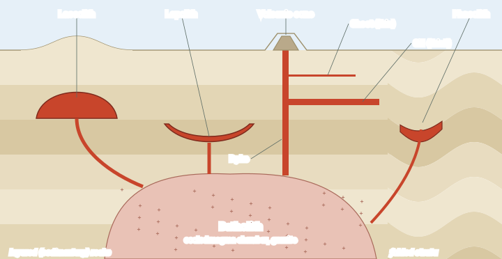
Intrusive forms at a glance
| Form | Shape | Position in the rock | Example or note |
|---|---|---|---|
| Batholith | Huge dome of granite, no known floor | Deep in the crust; the cooled magma chamber | Exposed by denudation; over 100 km² (USGS) |
| Laccolith | Dome with a level base, fed by a pipe from below | Pushes the overlying layers up | Karnataka plateau granite domes (NCERT) |
| Lapolith | Saucer, "concave to the sky" | Spreads along a weak horizontal plane | Fed from below |
| Phacolith | Wavy, lens-shaped mass | Base of synclines or top of anticlines | Found in folded country |
| Sill / sheet | Near-horizontal sheet | Along the layers; sills thick, sheets thin | - |
| Dyke | Wall-like, near vertical | Cuts across the layers | Western Maharashtra; feeders of the Deccan Traps |
NCERT, Fundamentals of Physical Geography, Class XI, chapter 3 "Interior of the Earth" (Rationalised 2023-24); USGS glossary: batholith, dike.
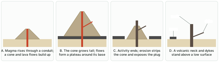
When erosion takes the cone away
Erosion eventually exposes what lies beneath a volcano. The USGS describes the life of a composite volcano in four stages. Magma rises through a conduit and builds a cone; over hundreds of years the cone grows and lava flows form a plateau around its base. When activity stops, erosion strips the cone and exposes the hardened volcanic plug in the conduit, while streams cut the plateau into isolated lava-capped mesas. In the end only a projecting plug, the volcanic neck, a small mesa and the dykes remain above a surface of low relief.
Exam tip
Match the form to its orientation: sills and sheets lie along the layers, dykes cut across them, laccoliths dome them upward, lapoliths sag like a saucer, phacoliths follow folds, and batholiths underlie them all. A question that describes the shape usually names the form.
Extrusive landforms
Extrusive landforms are built by what erupts. The part on volcanoes described the main volcano types; here the focus is on the landforms they create and the smaller features on them.
- Lava plateaus. Basaltic lava may pour out quietly from long fissures and flood the surrounding countryside, flow upon flow, forming broad plateaus (USGS). Examples are Iceland and the Columbia River and Snake River regions of Washington, Oregon and Idaho in the United States, where the flows exposed along the rivers measure more than a mile (1.6 km) in total thickness, and India's Deccan Traps (see below).
- Cones. Cinder cones are built of fragments falling around one vent; spatter cones, made of welded lava clots, are small (typically 10 m or less high) and commonly form in lines along a fissure; composite and shield volcanoes are cones on a far larger scale (USGS).
- Craters and calderas. A crater is the bowl around a vent, excavated mainly by explosions. A caldera is far larger, a basin formed by collapse after magma is withdrawn, from about 2 to 50 km across (USGS). Calderas often fill with water: Crater Lake in Oregon fills the caldera of Mount Mazama, with the small cinder cone of Wizard Island rising from it. In some large calderas the floor is later pushed up again by fresh magma, forming a resurgent dome.
- Maars. A maar is a low, broad crater formed by shallow explosions when magma heats and boils groundwater; maars often fill with water to form a lake (USGS).
- Lava tubes and tumuli. Lava tubes are natural tunnels through which lava keeps flowing beneath a crusted surface; they form when lava channels and pahoehoe flows crust over. Where molten lava pushes the crust of a pahoehoe flow up, it raises a dome-shaped tumulus (USGS).
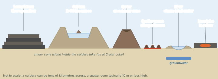
Don't confuse
A crater is small and made by explosions; a caldera is large (2-50 km) and made by collapse; a maar is a broad, shallow crater made by steam explosions where magma meets groundwater. All three can hold lakes.
Lava types: aa, pahoehoe and pillow lava
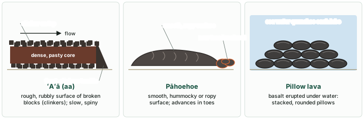
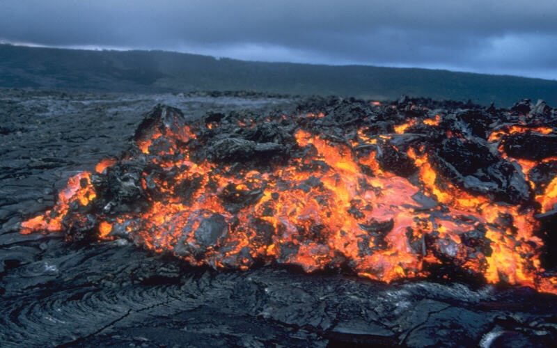
The same basalt can solidify with very different surfaces. Geologists name the two land surfaces with Hawaiian terms, ‘a‘ā and pāhoehoe (USGS).
- ʻAʻā (aa), pronounced "ah-ah", is lava with a rough, rubbly surface of broken blocks called clinkers. The spiny surface makes walking very difficult. The clinkers cover a massive, dense core, the most active part of the flow; as the pasty core moves downslope it carries the clinkers along, and at the front they tumble down and are buried by the advancing flow, so an aa flow has rubble at its base as well as on top.
- Pāhoehoe is basaltic lava with a smooth, hummocky or ropy surface. It advances as a series of small lobes and toes that keep breaking out from a cooled crust.
- Pillow lava forms when hot basalt erupts under water: each lobe oozes out, a flexible glassy crust forms as it is quenched, pressure builds until the crust breaks, and new lava squeezes out "like toothpaste" to form the next pillow. Because pillows form under water, geologists who find them in ancient rocks conclude that the area was once under water (USGS). The part on sea-floor spreading also covers pillow lava on the ocean floor.
More viscous lavas behave differently again: andesite typically forms thick, stubby flows, dacite often forms steep-sided lava domes, and rhyolite forms thick blocky flows or domes (USGS).
The Deccan Traps
The Deccan Traps are India's flood basalt province. NCERT describes flood basalt provinces as outpourings of highly fluid lava that flow for long distances: some flows are more than 50 m thick and individual flows may extend for hundreds of kilometres. The Deccan Traps presently cover "most of the Maharashtra plateau", and the trap formations are believed to have covered a much larger area at first. The lava rose through fissures, and the dykes that fed it are the commonest intrusive forms in western Maharashtra (NCERT).
Current research adds numbers. According to Oregon State University's Volcano World, the Deccan basalts are a pile of flat-lying flows more than 2,000 m (6,500 feet) thick in total, covering nearly 500,000 km² today; estimates of the original area run as high as 1.5 million km², and the volume is estimated at about 512,000 km³.
When did the Deccan erupt?
Here NCERT and current research differ, and an aspirant should know both. NCERT's chapter on the distribution of oceans and continents says the outpouring "started somewhere around 60 million years ago and continued for a long period of time", while the Indian subcontinent was still close to the equator. Radiometric dating places the main eruptions earlier: a rhenium-osmium age of 65.6 ± 0.3 million years (Allègre et al., 1999, as cited by Sheth, who questions that isochron), and uranium-lead dating by Schoene and colleagues (2019), which resolves four high-volume eruptive periods with the highest eruption rates before and after the K-Pg extinction, about 66 million years ago.
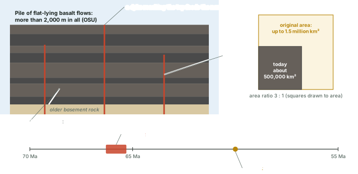
The Deccan Traps: NCERT and current research
| Aspect | NCERT | Current research |
|---|---|---|
| Age | "Around 60 million years ago", continuing for a long period | Main eruptions about 66-65 Ma (Re-Os 65.6 ± 0.3 Ma; Schoene et al. 2019) |
| Extent | "Most of the Maharashtra plateau"; once much larger | About 500,000 km² today; originally up to 1.5 million km² (OSU) |
| Thickness | Some single flows more than 50 m | Whole pile more than 2,000 m (OSU) |
| Volume | - | About 512,000 km³ (OSU estimate) |
| Feeders | Dykes, common in western Maharashtra | - |
| Cause | - | Generally attributed to the Réunion mantle plume; disputed by some (Sheth) |
NCERT, Fundamentals of Physical Geography, Class XI, chapter 3 "Interior of the Earth" (Rationalised 2023-24); NCERT, Fundamentals of Physical Geography, Class XI, chapter 4 "Distribution of Oceans and Continents" (Reprint 2025-26); Oregon State University, Volcano World, "Deccan Traps"; Sheth, MantlePlumes.org, "Deccan"; Schoene et al. 2019.
Hypothesis: The Deccan and the K-Pg extinction
The Deccan eruptions coincided with the mass extinction at the end of the Cretaceous (the K-Pg boundary), when the non-avian dinosaurs died out. Both the Chicxulub impact and Deccan volcanism are implicated, and one eruptive pulse began tens of thousands of years before both the impact and the extinction (Schoene et al., 2019).
Hypothesis: A plume beneath India
In the widely accepted mantle plume model, the Deccan came from the “head” of the plume whose narrow “tail” now feeds Réunion Island in the Indian Ocean (as summarised by Sheth). This is a model, not settled fact: Sheth himself argues that the Réunion plume model for the Deccan is wrong.
Exam tip
For the exam, quote NCERT's "around 60 million years ago" and add that radiometric dating now places the main eruptions at about 66-65 million years, close to the K-Pg boundary.
Hotspot chains: Hawaii and beyond
The Hawaiian Islands lie in the middle of the Pacific, more than 3,200 km from the nearest plate boundary. In 1963 J. Tuzo Wilson, the Canadian geophysicist who discovered transform faults, proposed the "hotspot" theory: small, long-lasting, exceptionally hot regions below the plates provide a steady, local source of heat that sustains volcanism (USGS). Wilson hypothesised that the Pacific plate moves over a deep, stationary hotspot beneath the Island of Hawaii. Magma from the hotspot, lighter than the surrounding rock, rises and erupts on the sea floor, building a seamount that grows into an island volcano. Plate motion then carries the island away from the hotspot; cut off from its magma, it becomes extinct and is slowly eroded, while a new volcano grows over the hotspot.
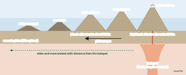
The prediction is testable: the islands should get older away from the hotspot, and they do. The oldest volcanic rocks on Kauai, in the north-west, are about 5.5 million years old and deeply eroded, while on the Big Island, in the south-east, the oldest exposed rocks are less than 0.7 million years old and new rock is still forming (USGS). Ancient Hawaiians had noticed the same pattern from erosion and soil: in legend, the fire goddess Pele moved from Kauai south-east to Hawaii, where she lives in Halemaʻumaʻu crater. The whole Hawaiian Ridge-Emperor Seamounts chain extends some 6,000 km to the Aleutian Trench and records about 70 million years of activity; a bend in the chain marks a change in the Pacific plate's motion about 43 million years ago, after which it has moved west-northwest (USGS).
Worked example: How fast has the Pacific plate moved over the hotspot?
The Hawaiian-Emperor chain is about 6,000 km long and records about 70 million years of activity. What average rate of plate motion does that imply?
- Convert the length to centimetres: 6,000 km = 6,000 × 100,000 cm = 600,000,000 cm.
- Divide by the time: 600,000,000 cm / 70,000,000 years.
- = 8.6 cm a year.
Answer: About 9 cm a year on average (computed). This is only a rough average: the chain bends, so the motion was not steady, and the calculation assumes, as Wilson did, that the hotspot stays fixed.
Hawaii is perhaps the best-known hotspot, but more than a hundred hotspots have been active in the past 10 million years. Most lie under plate interiors, such as the African plate; some lie near spreading ridges, as beneath Iceland, the Azores and the Galápagos (USGS). Réunion, in the Indian Ocean, is another: its Piton de la Fournaise is an intraplate shield volcano that erupted again from February to March 2026 (GVP).
Don't confuse
A hotspot chain and a volcanic arc both make lines of volcanoes, for different reasons. An arc (Japan, the Andes, the Andaman arc described in the part on volcanoes) follows a subduction zone and has active volcanoes along its length; a hotspot chain is a trail across a plate whose active end lies over the hotspot.
Yellowstone: a hotspot under a continent
A few hotspots are thought to lie beneath continents; the best known is the hotspot "presumed to exist" under Yellowstone National Park in north-western Wyoming, USA (USGS). The Yellowstone Plateau has had "three great prehistoric eruptions" (USGS Fact Sheet 2005-3024). The first, 2.1 million years ago, was "one of the five largest individual volcanic eruptions known anywhere on the Earth"; the second, 1.3 million years ago, was smaller but still huge; and the third, about 640,000 years ago, formed the Yellowstone Caldera. A 2022 USGS article dates the caldera-forming eruption to 631,000 years ago and classes the biggest Yellowstone eruptions as VEI 8 (see the VEI ladder), while noting some evidence that a few of them may have been made up of multiple smaller eruptions separated by gaps of up to decades.
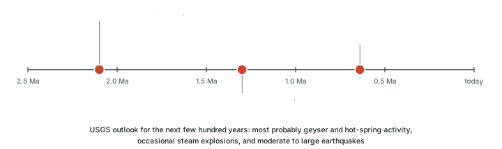
Yellowstone is still volcanically alive. Ground motions, earthquakes and hydrothermal activity are all current expressions of its volcanism, and faults and fractures let surface water sink to depth, be heated and rise again as hot springs and geysers. For the next few hundred years, the USGS expects the hazards to be "most probably limited to ongoing geyser and hot-spring activity, occasional steam explosions, and moderate to large earthquakes".
Don't confuse
"Super-eruption" is not a volcano type like a shield or a cone. The USGS uses it for eruptions of VEI 8, with ash deposits of more than 1,000 km³ (see volcanoes). The volcanoes that produced them, such as Yellowstone and Toba, are calderas in the GVP database, not tall mountains.
Hot springs, geysers, fumaroles and mudpots
Where groundwater meets volcanic heat it produces hydrothermal ("hot water") features. Yellowstone has more than 10,000 of them, including more than 500 geysers, and more geysers than anywhere else on Earth (US National Park Service), which names five types. Four of them are:
- Hot springs, the most common. Rain water seeps through the bedrock, is superheated at depth and rises back through open plumbing. Convection keeps the water circulating, so it never gets hot enough to erupt.
- Geysers are hot springs with one or more constrictions in their plumbing, usually near the surface. Deep down, the water can be hotter than the surface boiling point (about 93 °C there) without boiling, because the weight of the water and rock above keeps it under pressure. As it heats, steam forms and expands; at a critical point the bubbles lift the water above the vent, the pressure drops, and the water flashes violently to steam, driving an eruption until the reservoir is emptied or the system cools.
- Fumaroles or steam vents, the hottest features, have so little water that it boils away before reaching the surface; at Yellowstone steam vents reach up to 138 °C.
- Mudpots form where surface water collects in a shallow, clay-lined hollow heated by steam from below. Microbes help turn the hydrogen sulphide gas into sulphuric acid, which breaks rock down into a bubbling clay.
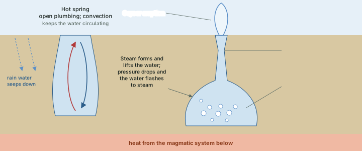
Old Faithful, the best-known geyser, erupts about 17 times a day, at intervals of 60 to 110 minutes; each eruption lasts 1.5 to 5 minutes and reaches 32-56 m, about 40 m on average. Steamboat Geyser, the largest in the world, reaches 300 to 400 feet (about 90-120 m). Hot water rising through silica-rich rhyolite dissolves silica and deposits it at the surface as sinter, which builds the cones of cone geysers; where hot water rises through limestone, as at Mammoth Hot Springs, it deposits travertine terraces of calcium carbonate (US National Park Service).
In India, the Geological Survey of India (GSI) has mapped 381 hot springs (PIB, September 2026). The hot springs of Puga Valley in Ladakh mark one of India's most promising geothermal sites (see below).
Geothermal energy
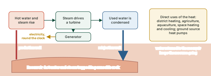
Geothermal energy is heat from the Earth's interior, generated by the radioactive decay of elements such as uranium, thorium and potassium and by heat left over from the planet's formation. In geologically active regions, faults and fractures let this heat come close to the surface, creating reservoirs of hot water and steam trapped in permeable rock (PIB). Unlike solar and wind power, it is available round the clock.
A geothermal power plant works much like a thermal power station, with the furnace replaced by the Earth. Deep wells bring the hot water and steam to the surface; the steam drives a turbine connected to a generator; and the used water is condensed and injected back into the reservoir, which helps replenish it. The heat can also be used directly, for district heating, agriculture, aquaculture and the heating and cooling of buildings, and ground source heat pumps tap the shallow ground for the same purpose (PIB).
The world and India
Worldwide, installed geothermal capacity reached 15.67 GW by the end of 2025; Indonesia, the United States, the Philippines, Türkiye and New Zealand together hold about 67% of it (PIB).
In India the GSI has mapped 381 hot springs and identified 10 geothermal provinces: the Himalayan province, Naga-Lusai, the Andaman and Nicobar Islands, Son-Narmada-Tapi (SONATA), the West Coast, the Cambay Graben, the Aravalli, the Mahanadi, the Godavari and the South Indian Cratonic regions. The theoretical potential is put at nearly 10.6 GW, and 42 sites are recognised as promising for power generation and direct heat use (PIB).
India's geothermal position (as of September 2026)
| Item | Status |
|---|---|
| Hot springs mapped by GSI | 381 |
| Geothermal provinces | 10 (Himalayan, Naga-Lusai, Andaman and Nicobar, SONATA, West Coast, Cambay Graben, Aravalli, Mahanadi, Godavari, South Indian Cratonic) |
| Theoretical potential | Nearly 10.6 GW; 42 promising sites |
| Policy | National Policy on Geothermal Energy notified September 2025; MNRE is the nodal ministry |
| Research and development | Five MNRE-sanctioned projects (July-August 2025): resource assessment, technology, field demonstration |
| Deep wells | Two 1,000 m wells commissioned by ONGC Energy Centre at Puga Valley, Ladakh, July 2026 |
| Power generation | First 1 MW demonstration plant planned at Puga; commercial-scale generation not yet established |
| Demonstrations | Gandhinagar, Gujarat: three wells giving fluid at 70-80 °C, 50-90 kW generated with solar integration |
PIB, "Harnessing Geothermal Energy for a Sustainable India" (4 Sep 2026).
The policy that frames this work, the National Policy on Geothermal Energy, was notified in September 2025, with the Ministry of New and Renewable Energy (MNRE) as the nodal ministry. It prioritises research, drilling, reservoir management and direct use, supports ground source heat pumps, and allows abandoned oil and gas wells to be repurposed for geothermal use, building on the drilling expertise of the oil and gas sector (PIB). A pilot at Ankleshwar in Gujarat is testing electricity generation from unproductive oil and gas wells, and studies are under way at five geothermal sites around Tawang in Arunachal Pradesh (PIB).
In the news
In July 2026 the ONGC Energy Centre commissioned two geothermal wells, which the government calls India's first, each 1,000 m deep, in Puga Valley, Ladakh, more than 14,000 feet (about 4,270 m) above sea level. The wells are for reservoir evaluation. They "pave the way" for India's first 1-megawatt demonstration geothermal power plant, which is planned, not yet built; as PIB notes, commercial-scale geothermal power is yet to be established in India (PIB, 4 September 2026).
Summary
- Magma that cools in the crust forms plutonic rock and intrusive landforms; lava that cools at the surface forms volcanic rock and extrusive landforms (NCERT).
- NCERT's intrusive forms: batholith (the cooled magma chamber), laccolith (dome with a level base), lapolith (saucer), phacolith (wavy, in folds), sill and sheet (horizontal), dyke (vertical wall). Erosion exposes them and can leave a volcanic neck.
- Extrusive forms include lava plateaus, cinder and spatter cones, craters (small, explosive), calderas (2-50 km, collapse) and maars (steam blasts), with lava tubes and tumuli on the flows.
- Basalt solidifies as rubbly aa, smooth ropy pahoehoe, or pillow lava under water.
- The Deccan Traps: NCERT dates them to about 60 million years ago; research places the main eruptions at about 66-65 million years, around the K-Pg boundary; about 500,000 km² today, more than 2,000 m thick.
- A plate moving over a hotspot leaves a chain of volcanoes that age with distance: Kauai about 5.5 Ma, the Big Island under 0.7 Ma. Yellowstone, a presumed continental hotspot, had three great eruptions (2.1 Ma, 1.3 Ma and about 640,000 years ago).
- Hot springs have open plumbing; geysers have constrictions that trap superheated water.
- India: 381 hot springs, 10 geothermal provinces, about 10.6 GW potential; two 1,000 m wells at Puga (July 2026), with a 1 MW demonstration plant planned.
Sources
Each table and data figure names its source beneath it. The main documents are collected here, with a date where the source carries one. Figures not listed under image credits were drawn for this page from the data and formulas stated in their source lines.
Main sources
| Topic | Source |
|---|---|
| Textbook | NCERT Class XI, Fundamentals of Physical Geography, ch. 3, The Interior of the Earth (Rationalised 2023-24); ch. 4, Distribution of Oceans and Continents (Reprint 2025-26) |
| Intrusive and extrusive landforms | USGS, Volcanoes: types; USGS glossary: batholith, dike, intrusive, caldera, maar, spatter cone, cinder cone |
| Lava types | USGS glossary: aa, pahoehoe, pillow lava |
| Deccan Traps | Oregon State University, Deccan Traps; Sheth, MantlePlumes.org; Schoene et al., Science 363 (2019) 862-866 |
| Hotspots and Yellowstone | USGS, Hotspots; USGS, Hawaiian-Emperor chain; USGS Fact Sheet 2005-3024, Yellowstone; USGS Yellowstone Volcano Observatory, "The Volcanic Explosivity Index" (26 Dec 2022) |
| Hot springs and geysers | US National Park Service, Yellowstone hydrothermal features (updated 17 Apr 2025) |
| Geothermal energy | PIB, "Harnessing Geothermal Energy for a Sustainable India" (4 Sep 2026) |
Image credits
| Image | Credit and licence |
|---|---|
| Aa lava front over pahoehoe, Kilauea | USGS. Public domain. File page |
| All other figures | Drawn for this page from the data and formulas given in their source lines. |