 BharatNotes
Part 6 of 7 of the Plate Tectonics and Volcanism notes. The overview page has the quick revision, exam strategy, vocabulary and key terms for all seven parts.
Volcanoes and Eruptions
A volcano is where the Earth's interior reaches the surface: molten rock, gas and broken rock escape through a vent. This part explains where the molten rock comes from, why some volcanoes pour out quiet rivers of lava while others explode, how volcanoes are classified by activity, eruption style and form, how the size of an eruption is measured, where volcanoes cluster on the globe, what the great eruptions taught us about climate, and how India's own volcanoes in the Andaman Sea fit the picture. It closes with the eruptions of 2024 to 2026.
Cross-paper relevance
- GS1 (Geography, primary): magma and lava, eruption styles, volcano types, the VEI, the Ring of Fire and other volcanic settings, great eruptions and their effect on climate, Barren Island and Narcondam
- GS3 (Disaster management): volcanic hazards such as pyroclastic flows, lahars and ash clouds that disrupt air travel; monitoring of earthquakes, swelling, gas and heat; volcano alert levels
What a volcano is: magma and lava
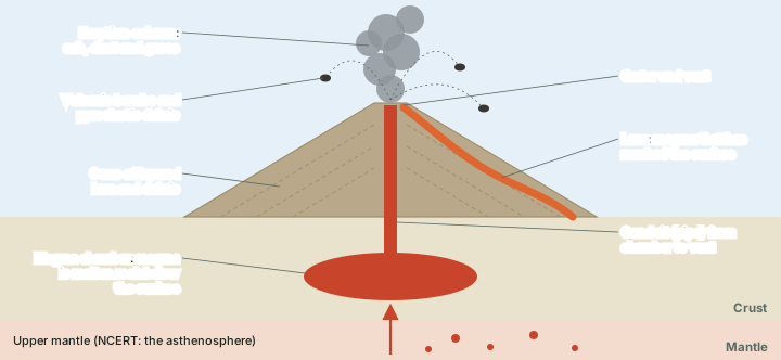
NCERT defines a volcano as "a place where gases, ashes and/or molten rock material – lava – escape to the ground". The molten rock begins deep down. Below the solid crust lies the mantle, and the mantle contains a weaker zone, the asthenosphere; NCERT traces the molten rock materials to this zone (the part on the Earth's interior explains why the asthenosphere is weak and partly plastic rather than molten). Molten rock that is still below the surface is magma. NCERT adds that once it starts moving towards the crust or reaches the surface it is called lava; the USGS draws the line more strictly, keeping "magma" for molten rock beneath the surface and "lava" for magma that has been erupted onto it.
Magma rises because it is lighter than the solid rock around it (USGS). It usually collects in a magma chamber in the crust, the store beneath the vent, and reaches the surface through a pipe-like conduit. Where the conduit opens at the surface is the vent, and the bowl around it is the crater.
According to NCERT, the material that reaches the ground includes lava flows, pyroclastic debris, volcanic bombs, ash and dust, and gases: nitrogen compounds, sulphur compounds and minor amounts of chlorine, hydrogen and argon. The broken material has its own vocabulary, defined by the USGS:
- Tephra: any rock fragment, of any size, thrown out of a volcano that travels through the air (ash, bombs, scoria).
- Ash: fine fragments, less than 2-4 mm across.
- Bombs are lumps of lava, many of which take rounded, aerodynamic shapes in flight; blocks are commonly solidified pieces of old lava flows that were part of the volcano's cone.
- Pumice is magma frothed by escaping gas, so light that rhyolitic pumice can float on water; scoria is its denser, less bubbly cousin, usually basaltic or andesitic.
- A pyroclastic flow is a hot (typically above 800 °C), chaotic mixture of rock fragments, gas and ash that races away from the vent at tens of metres a second.
- A lahar is a volcanic mudflow: a fast mixture of rock debris and water, formed when an eruption melts snow and ice, when heavy rain falls on loose ash, or when a lake dammed by volcanic debris bursts.
Remember
Magma is below the surface; lava is at the surface. NCERT also uses "lava" for molten rock moving up through the crust and for the intrusive bodies described in the part on volcanic landforms, so in an NCERT-based answer you may see "lava" where a geologist would write "magma".
Don't confuse
A pyroclastic flow is a glowing avalanche of hot gas and rock fragments; a lahar is a mudflow of water and debris. Lahars can strike long after an eruption and far down river valleys.
Why some volcanoes explode: silica, viscosity and gas
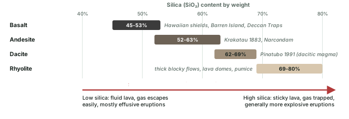
Whether an eruption is a gentle outpouring or a violent blast depends mostly on how runny the magma is and how easily its dissolved gas can escape. The key ingredient is silica (silicon dioxide), the most abundant rock-forming compound on Earth. In the USGS's explanation, silica tends to link into molecular chains, which makes magma more viscous. Basaltic magma, with less silica, is fairly fluid; andesite, dacite and rhyolite magmas become progressively stickier. "Because it is more difficult for dissolved gas to escape from more viscous magma, higher silica magmas generally erupt more explosively."
Think of gas in a fizzy drink. In runny basalt the bubbles rise and burst quietly at the surface, feeding fountains and lava flows. In sticky rhyolite the bubbles cannot get out; pressure builds until the magma shatters into ash and pumice. Temperature matters too: basaltic lava can be as hot as 1,170 °C, while andesites erupt at 900-1,100 °C (USGS), and cooler lava is more viscous, which is why NCERT describes composite volcanoes as erupting "cooler and more viscous lavas than basalt".
Why it happens
Water can make even basalt explosive. NCERT notes that shield volcanoes "become explosive if somehow water gets into the vent". When groundwater or sea water meets magma it flashes to steam and expands violently: the principle behind phreatic and phreatomagmatic eruptions (see the eruption styles below), and the reason the underwater Hunga Tonga eruption of 2022 was so violent (see the great eruptions below).
Volcanoes by activity: active, dormant and extinct
NCERT calls a volcano active "if the materials mentioned are being released or have been released out in the recent past". In everyday use, a volcano that is quiet now but may erupt again is called dormant, and one that is not expected to erupt again is extinct. These words have no fixed time limits, so volcanologists prefer a record-based test. The Smithsonian Institution's Global Volcanism Program (GVP), which keeps the Volcanoes of the World database, lists separately the volcanoes that have erupted in the Holocene, the past approximately 12,000 years (USGS definition), and those known only from older, Pleistocene activity.
India offers both cases within 140 km of each other. Barren Island has a long written record of eruptions, the first in 1787, and erupted again from July 2025 to January 2026. Narcondam appears in the GVP's list of Pleistocene volcanoes: a 2017 review found no documented Holocene activity. By NCERT's definition, Barren Island is active and Narcondam is not (see India's volcanoes below).
Exam tip
A long quiet spell does not by itself make a volcano extinct. Volcanologists judge a volcano by its geological record (here, the GVP's Holocene test) and by monitoring (see the section on monitoring below), not by living memory.
Volcanoes by eruption style
The broadest division is between effusive eruptions, dominated by the outpouring of lava flows and domes, and explosive eruptions, which produce mainly ash, pumice and ballistic fragments (USGS). Within these, eruption styles are traditionally named after a well-known volcano that behaves that way. A volcano may show only one style during an episode of activity, or run through a whole sequence of them (USGS).
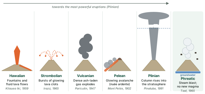
- Hawaiian: fluid basalt spurts from fissures on a rift zone or from a central vent as lava fountains (typically 10-100 m high, occasionally more than 500 m), feeding lava streams and lava lakes. Examples: Mauna Loa 1950 (fissure) and Kilauea Iki, Kilauea, 1959 (central vent).
- Strombolian: huge clots of molten lava burst from the crater in glowing arcs and stream down the flanks (Irazú, Costa Rica, 1965).
- Vulcanian: a dense cloud of ash-laden gas explodes from the crater and rises high above the peak (Parícutin, Mexico, 1947).
- Pelean (nuée ardente, "glowing cloud"): gas, ash and incandescent fragments are blown out, fall back and race downslope as glowing avalanches at up to about 100 miles (160 km) an hour, as at Mayon in 1968 and, catastrophically, Mont Pelée in 1902.
- Plinian: the most powerful eruptions, ejecting viscous magma as enormous columns of tephra and gas into the stratosphere (above 11 km). They are named after Pliny the Younger, who described the eruption of Vesuvius in 79 CE that killed about 2,000 people, among them Pliny the Elder. Mount St Helens on 18 May 1980 and Pinatubo on 15 June 1991 were Plinian.
- Phreatic (steam-blast): ground or surface water heated by magma or hot rock flashes to steam. Only fragments of old rock are blasted out; no new magma is erupted. Usually weak, but violent at Taal, Philippines, in 1965. When magma and water both take part, the eruption is phreatomagmatic.
Volcanoes by form
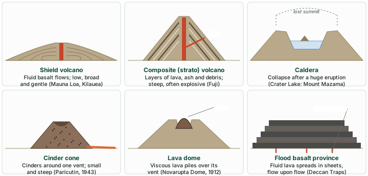
NCERT classifies volcanoes "on the basis of nature of eruption and the form developed at the surface" and names five major types. The USGS groups land volcanoes into four main kinds (cinder cones, composite volcanoes, shield volcanoes and lava domes). The two lists overlap; together they cover every form an examiner can ask about.
Shield volcanoes
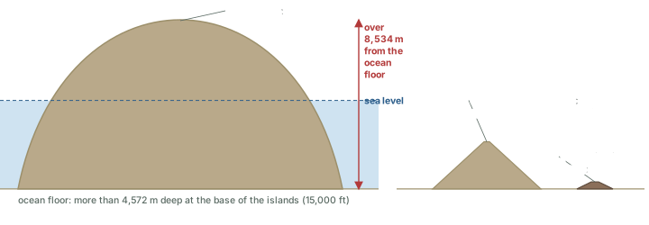
"Barring the basalt flows, the shield volcanoes are the largest of all the volcanoes on the earth" (NCERT). They are built almost entirely of fluid basalt flows that pour out in all directions from a summit vent or from rift zones on the flanks, cooling as thin, gently dipping sheets; the result is a broad, gently sloping cone with a profile like a warrior's shield (USGS). Because the lava is fluid, NCERT notes, these volcanoes are not steep and have low explosivity unless water gets into the vent. Lava fountaining at the vent can throw up a small cinder cone. The Hawaiian volcanoes are the classic examples. Mauna Loa, the largest, stands 13,677 feet (about 4,170 m) above sea level, and its top is over 28,000 feet (about 8,530 m) above the deep ocean floor.
Composite volcanoes (stratovolcanoes)
Composite volcanoes erupt cooler, more viscous lavas than basalt and are often explosive. Along with lava, large quantities of pyroclastic material and ash pile up around the vent in layers, which is what makes them "composite" (NCERT). The USGS describes them as steep, symmetrical cones built over tens to hundreds of thousands of years, rising as much as 8,000 feet (about 2,440 m) above their bases. Lava that hardens in fissures forms dykes that act as ribs strengthening the cone. Mount Fuji, Cotopaxi, Mount Rainier and Mount St Helens are examples, and so are both of India's island volcanoes (see India's volcanoes below). When a composite volcano falls silent, erosion strips the cone until only the hardened plug of the conduit, a volcanic neck, and its dykes stand above the land.
Calderas
NCERT calls calderas "the most explosive of the earth's volcanoes": they erupt so violently that they collapse on themselves instead of building a tall structure, and the collapsed depression is the caldera. Their explosiveness shows that the magma chamber is both huge and close to the surface. In the USGS definition a caldera is a large basin-shaped depression, roughly 2 to 50 km across, formed when so much magma is withdrawn from a shallow reservoir that the ground above loses its support and collapses. Crater Lake in Oregon fills the caldera of Mount Mazama, which lost its top in tremendous explosions about 6,800 years ago; a last small cinder cone, Wizard Island, rises above the lake.
Flood basalt provinces and mid-ocean ridge volcanoes
Flood basalt provinces pour out highly fluid lava that flows for long distances, covering thousands of square kilometres; some individual flows are more than 50 m thick and extend for hundreds of kilometres (NCERT). The Deccan Traps, which cover most of the Maharashtra plateau, are India's example and are treated in the part on volcanic landforms. The fifth NCERT type, mid-ocean ridge volcanoes, erupts along the ridge system of the ocean floor; NCERT gives its length as "more than 70,000 km", while NOAA gives about 65,000 km (40,389 miles). The part on sea-floor spreading explains how the ridges form.
Cinder cones and lava domes
A cinder cone is the simplest volcano: a small, steep cone of cinders that fall around a single vent, usually with a bowl-shaped crater (USGS). In 1943 one began growing on a farm near the village of Parícutin in Mexico; in nine years it built a cone about 1,200 feet (about 370 m) high, covered about 100 square miles with ash and destroyed the town of San Juan. A lava dome is a bulbous mass of lava too viscous to flow far, which piles up over its vent and grows from within. The Novarupta Dome, formed in the 1912 eruption in Alaska, is about 800 feet across and 200 feet high; a dome was growing at Mont Pelée when it destroyed Saint-Pierre in 1902.
Volcano types: NCERT's five and the USGS additions
| Type | Lava and eruption | Form | Examples |
|---|---|---|---|
| Shield (NCERT) | Fluid basalt; low explosivity unless water enters the vent | Broad, gentle, built of thin flows; the largest volcanoes | Mauna Loa, Kilauea |
| Composite (NCERT) | Cooler, more viscous lava; often explosive; much ash and debris | Steep cone of alternating layers | Fuji, St Helens, Pinatubo, Barren Island |
| Caldera (NCERT) | "The most explosive"; huge, shallow magma chamber | Collapsed basin, 2 to 50 km across | Krakatau, Hunga Tonga, Crater Lake, Toba |
| Flood basalt (NCERT) | Highly fluid lava flowing long distances | Plateau of stacked sheets, flows over 50 m thick | Deccan Traps, Columbia River basalts |
| Mid-ocean ridge (NCERT) | Frequent eruptions along the ridge crest | Ridge system more than 70,000 km (NCERT); about 65,000 km (NOAA) | Iceland; East Pacific Rise |
| Cinder cone (USGS) | Gas-charged lava blown into cinders | Small, steep cone around one vent | Parícutin; Wizard Island |
| Lava dome (USGS) | Lava too viscous to flow far | Bulbous mound over the vent, often in a crater | Novarupta Dome, Mont Pelée |
NCERT, Fundamentals of Physical Geography, Class XI, chapter 3 "Interior of the Earth" (Rationalised 2023-24); USGS General Interest Publication Volcanoes, "Principal types of volcanoes"; USGS glossary: caldera; NOAA Ocean Service, "What is the mid-ocean ridge?"; volcano types: GVP Holocene volcanoes database (read 25 Oct 2026); Columbia River basalts: USGS glossary: basalt.
Measuring the size of an eruption: the VEI
Earthquakes have magnitudes read from seismometers; eruptions have no such instrument. The standard yardstick is the Volcanic Explosivity Index (VEI), proposed in 1982 by Chris Newhall of the USGS and Stephen Self of the University of Hawaii. It combines several kinds of evidence: the volume of tephra erupted, the height of the eruption cloud, its duration, and descriptive terms ranging from "gentle" to "mega-colossal" (USGS).
The main measure is the volume of ash and other tephra. Like the earthquake magnitude scale it is logarithmic: each step is ten times the one below, except at the bottom, where VEI 1 spans two orders of magnitude. A VEI 0 eruption is non-explosive, ejecting less than 10,000 m³. A VEI 4 eruption ejects about 0.1 km³ (La Soufrière, St Vincent, 2021), a VEI 5 about 1 km³ (Mount St Helens, 1980) and a VEI 6 about 10 km³ (Pinatubo, 1991). VEI 8, the "super-eruptions", means more than 1,000 km³; none has ever been observed. The scale is open-ended: the USGS notes that the Toba eruption in Indonesia, 74,000 years ago, was possibly VEI 9.
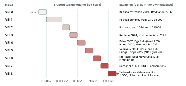
The VEI has limits worth knowing. Lava does not count, only explosive products. Duration counts: Parícutin ejected about 1.3 km³ of ash and fragments, which by volume alone suggests VEI 5, but it took nine years and was never violently explosive, so it is classed VEI 4 (USGS). And plume height can mislead: the Hunga Tonga plume of January 2022 rose extraordinarily high, yet the ash volume was closer to that of a smaller eruption. The GVP lists it as VEI 5 (a value the USGS calls preliminary), while NOAA's National Centers for Environmental Information (NCEI) give VEI 6.
Worked example: How much bigger is VEI 6 than VEI 4?
Pinatubo (1991) was VEI 6 and Eyjafjallajökull (2010) was VEI 4. Roughly how many times more tephra did Pinatubo erupt?
- Each VEI step above VEI 2 is a tenfold increase in erupted volume.
- From VEI 4 to VEI 6 is two steps: 10 × 10 = 100.
- Check with the USGS reference volumes: VEI 6 about 10 km³, VEI 4 about 0.1 km³; 10 / 0.1 = 100.
Answer: About 100 times more. The same logic makes a VEI 8 eruption about 1,000 times larger than Mount St Helens (VEI 5).
Don't confuse
The VEI measures how much an eruption throws out; it says nothing direct about deaths. The USGS points out that the 1985 eruption of Nevado del Ruiz in Colombia was small (VEI 3), yet its mudflows killed more than 25,000 people, while Mount St Helens (VEI 5) killed 57, partly because a hazard warning and a restricted zone were in place.
Where volcanoes occur
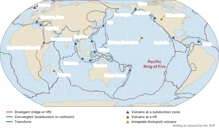
Volcanoes are not scattered at random. Most sit along plate boundaries (see plate boundaries), and the rest mark hotspots in the interiors of plates.
- Subduction zones (convergent boundaries). As an oceanic plate sinks into the mantle, melting above it feeds chains of composite volcanoes on the overriding plate: the volcanic arcs of Indonesia, Japan, the Philippines, the Andes and the Cascades. NCERT notes that the rim of the Pacific "is also called rim of fire due to the existence of active volcanoes". National Geographic describes this Ring of Fire as a horseshoe about 40,000 km long with 452 volcanoes, home to about 75% of the world's active volcanoes and about 90% of its earthquakes.
- Divergent boundaries. Mid-ocean ridges erupt basalt as plates pull apart (see sea-floor spreading); Iceland sits on part of the ridge system where a hotspot also lies (USGS). On land, rifts such as the Afar region of Ethiopia carry volcanoes like Erta Ale and Hayli Gubbi.
- Hotspots. Some volcanoes lie far from any boundary: Hawaii is more than 3,200 km from the nearest one (USGS). In 1963 J. Tuzo Wilson proposed that long-lasting, exceptionally hot regions below the plates feed such volcanoes; more than a hundred hotspots have been active in the past 10 million years, some beneath plate interiors and some near ridges, as under Iceland, the Azores and the Galápagos (USGS). How hotspots form and how they build island chains is the subject of the part on volcanic landforms.
Remember
Three settings, three typical kinds of volcano: subduction zones mostly give explosive composite volcanoes; ridges and rifts give fissure eruptions of basalt; hotspots give shield volcanoes in the oceans and, on a continent, giant calderas such as Yellowstone (see volcanic landforms).
Great eruptions and their effects on climate
A handful of eruptions are cited again and again because each taught something new. Their sizes come from the GVP database and their death tolls from NOAA NCEI; estimates of deaths vary widely between sources, especially for older events.
Great eruptions: size, toll and lesson
| Eruption | Date | VEI | Deaths | Why it matters |
|---|---|---|---|---|
| Vesuvius, Italy | 79 CE | 5 | about 2,000 (USGS) | Gave the name "Plinian": described by Pliny the Younger |
| Tambora, Indonesia | 10 Apr 1815 | 7 | 11,000 direct; 60,000 total (NCEI); 92,000 (USGS) | Ranks as "the largest known explosive eruption in historic times" (USGS) |
| Krakatau, Indonesia | climax 26-27 Aug 1883 | 6 | 36,417 (NCEI) | More than 4 cubic miles (about 17 km³) in 23 hours; heard about 4,650 km away |
| Mont Pelée, Martinique | 8 May 1902 | 4 | about 28,000 (NCEI); nearly 30,000 (USGS) | Glowing avalanche destroyed Saint-Pierre |
| Novarupta, Alaska | 1912 | 6 | – | With Pinatubo, one of the two largest eruptions of the 20th century |
| Mount St Helens, USA | 18 May 1980 | 5 | 57 (61 total, NCEI) | Lateral blast up to about 1,080 km/h devastated about 600 km² |
| Nevado del Ruiz, Colombia | Nov 1985 | 3 (USGS) | more than 25,000 (USGS) | A small eruption whose lahars caused a great disaster |
| Pinatubo, Philippines | climax 15 Jun 1991 | 6 | about 350 direct; about 800 total (NCEI) | Sulphate aerosols cooled the Northern Hemisphere |
| Eyjafjallajökull, Iceland | 20 Mar-23 Jun 2010 | 4 | – | Ash cloud disrupted European air travel in April 2010 |
| Hunga Tonga-Hunga Haʻapai | 15 Jan 2022 | 5 (GVP); 6 (NCEI) | 6 (NCEI) | Record water vapour into the stratosphere; pressure wave circled the globe |
VEI: Smithsonian Global Volcanism Program (GVP), Volcanoes of the World, Holocene eruptions database (read 24-25 Oct 2026; entries current to late March 2026), except Ruiz (USGS, "Mount St. Helens: comparisons with other eruptions"). Deaths: NOAA NCEI Significant Volcanic Eruptions Database (queries Krakatau, Pelée, Pinatubo, Tambora, St Helens, Tonga); Vesuvius: USGS glossary: Plinian; Tambora 92,000 and Ruiz: USGS, "Mount St. Helens: comparisons with other eruptions". Krakatau volume: USGS Publications Warehouse, Krakatau 1883; sound: Oregon State University, Volcano World, Krakatau 1883 (Rodrigues Island, 4,653 km). St Helens blast: US National Park Service, "Volcanic blasts". Novarupta and Pinatubo rank: Self et al., "The atmospheric impact of the 1991 Mount Pinatubo eruption" (USGS). – = no figure in the sources used.
Mount St Helens, 1980: the sideways blast
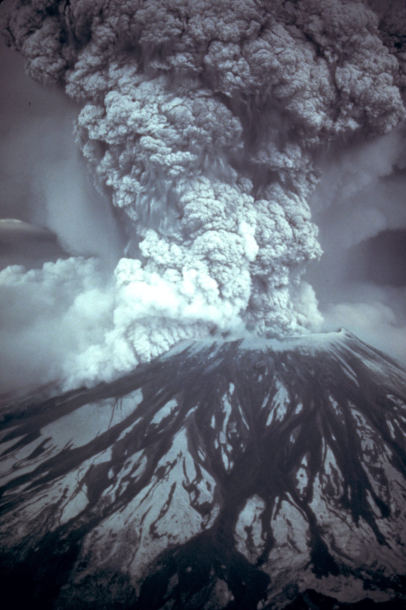
On 18 May 1980 Mount St Helens produced a lateral blast, a sideways explosion with a strong low-angle component (USGS), that the US National Park Service reports reached speeds up to 670 mph (about 1,080 km/h) and devastated about 230 square miles (about 600 km²). A Plinian column followed. The eruption killed 57 people (NCEI); the USGS notes the toll would have been far higher without the warnings and the restricted zone. In VEI terms it was a 5, "but just barely": its blast was powerful, its output of magma rather small (USGS).
Pinatubo, 1991: an eruption that cooled the planet
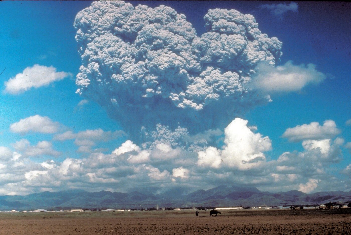
Pinatubo, on Luzon in the Philippines, erupted from 2 April to 2 September 1991, with its climax on 15 June. It produced 8.4 to 10.4 km³ of bulk material, about 5 km³ of dacitic magma when recalculated as solid rock (dense-rock equivalent), and the largest stratospheric sulphur dioxide cloud ever observed by modern instruments: 15 to 20 million tonnes of SO₂ (Self et al., USGS). The USGS paper ranks it as possibly the second-largest eruption of the twentieth century after Katmai-Novarupta in 1912; the GVP gives both VEI 6.
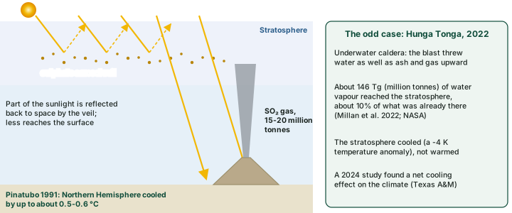
The climate effect came from the gas, not the ash. In the stratosphere the SO₂ turned into tiny droplets of sulphate aerosol. The veil spread around the Earth in about three weeks and covered the globe within about a year; by reflecting part of the incoming sunlight it reduced the radiation reaching the surface, and the Northern Hemisphere cooled by up to about 0.5-0.6 °C. The aerosols also sped up ozone loss: midlatitude ozone fell to its lowest levels on record in 1992-93 (Self et al.).
Krakatau 1883, Tambora 1815 and Mont Pelée 1902
Krakatau, in Indonesia, erupted from May to October 1883 and reached its climax on 26-27 August, when it ejected more than four cubic miles (about 17 km³) of volcanic debris in a 23-hour period (Simkin and Fiske, USGS, 1983). Oregon State University's Volcano World summary records that its explosions were heard on Rodrigues Island, about 4,650 km away, and that the dust veil lowered global temperatures by as much as 1.2 °C in the year after; temperatures did not return to normal until 1888. Tambora, on Sumbawa, erupted on 10 April 1815 at VEI 7, the largest explosive eruption in historic times (USGS); NOAA NCEI count 11,000 direct deaths and about 60,000 in all, and older USGS tables give 92,000, a reminder that early tolls are estimates. At Mont Pelée on Martinique, a glowing avalanche of hot ash and gas swept down on 8 May 1902 onto the town of Saint-Pierre, about 4 miles (6 km) away, and killed about 28,000 people (NCEI; the USGS says nearly 30,000). The USGS records that only two men survived, one of them in a poorly ventilated jail cell.
Hunga Tonga-Hunga Haʻapai, 2022: water instead of sulphur
On 15 January 2022 a submarine caldera in Tonga exploded beneath the sea. The eruption threw about 146 teragrams (146 million tonnes) of water vapour into the stratosphere, about 10% of the water already there (Millan et al., 2022, reported by NASA; another study gives up to 150 Tg). Water vapour is a greenhouse gas, and the eruption was put forward as a cause of the warm years of 2023-24. The observations point the other way: the stratosphere where the water spread cooled, with a temperature anomaly of about -4 K (Schoeberl et al., via NASA), and a 2024 study found that the eruption's net effect on the climate was a cooling, with more energy leaving the climate system than entering it, disputing that role (Texas A&M University). Its air pressure wave travelled around the Earth four times (plus three passages from the antipode) over six days (Matoza et al., Science, 2022).
Key idea
Ash makes the dramatic pictures, but sulphur makes the climate effect. Cooling needs large amounts of SO₂ lofted into the stratosphere, where the aerosol veil can spread around the globe: Pinatubo injected 15-20 million tonnes and cooled the Northern Hemisphere by up to about 0.5-0.6 °C. The VEI alone does not predict it.
India's volcanoes: Barren Island and Narcondam
India's two volcanoes rise from the Andaman Sea, east of the Andaman Islands. They sit on a north-south volcanic arc that runs between Sumatra and Myanmar, beside the subduction boundary between the Indian and Burma plates (the part on the Indian plate explains this boundary). Both are composite volcanoes (stratovolcanoes) in the GVP classification.
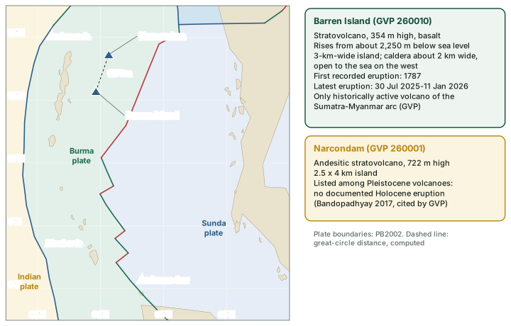
Barren Island lies about 135 km north-east of Port Blair. It is the emergent summit of a volcano that rises from about 2,250 m below sea level to 354 m above it. The small, uninhabited island, about 3 km wide, holds a caldera about 2 km wide with walls 250-350 m high; the caldera is open to the sea on the west and was formed in a major explosive eruption in the late Pleistocene. A cone of pyroclastic material stands in its centre, and lava flows that fill much of the caldera floor have reached the sea along the western coast. The GVP calls it "the only historically active volcano along the N-S volcanic arc extending between Sumatra and Burma (Myanmar)". Its rock is basalt.
Eruptions were recorded from 1787 to 1832, with a possible one in 1852. After a gap of more than a century, activity resumed in 1991 and has recurred ever since: 1994-95, 2005-07, 2008-10, 2010-11, 2013, 2013-14, 2015-16, 2017, 2018-19, 2019-22, 2022-23, March to May 2024, and 30 July 2025 to 11 January 2026, mostly at VEI 1 or 2. The island is remote and uninhabited, so recent eruptions have been tracked largely from space: the 2024 eruption was identified from satellite infrared data, and the GVP's reports on the 2022-23 eruption describe thermal activity seen from satellites.
Narcondam, about 130 km east of North Andaman Island, is an andesitic stratovolcano 722 m high on an island of 2.5 by 4 km. The GVP records that volcanism there was once thought to have continued into the Holocene, but its last eruption is unknown and a 2017 review found no documented Holocene activity, so the GVP lists it among Pleistocene volcanoes. Its name is said to mean "pit of hell", though the GVP suggests the name may have been transferred by mistake from the active Barren Island, 140 km to the south-south-west.
Exam tip
Barren Island: active, composite, basaltic, eruptions since 1787, latest 2025-26. Narcondam: andesitic, no documented Holocene eruption. Both lie in the Andaman Sea on the Burma plate, near its subduction boundary with the Indian plate.
Don't confuse
The Deccan Traps are not a volcano in the Barren Island sense. They are a flood basalt province, erupted from fissures about 66 million years ago (see volcanic landforms), with no active vent today.
Watching volcanoes: monitoring and alert levels
Magma moving beneath a volcano changes the ground above it, and those changes can be measured (USGS):
- Earthquakes. Seismometers record earthquakes beneath the volcano, including swarms of minor earthquakes.
- Ground deformation. A volcano swells as magma accumulates; the change is usually too small to see and is measured by GPS, tiltmeters, satellite radar (InSAR) and electronic distance meters. At Kilauea, summit tiltmeters tracked the inflation before each fountaining episode of 2024-26 (HVO).
- Gas. Instruments such as DOAS measure sulphur dioxide emission rates from the ultraviolet sunlight that SO₂ absorbs in a plume; FTIR spectrometers measure gases from the heat they absorb. Kilauea's summit released 1,000 to 5,000 tonnes of SO₂ a day even during pauses between episodes (HVO, October 2026).
- Heat. Satellites detect thermal anomalies; the start of Barren Island's 2024 eruption is dated from satellite infrared observations (GVP).
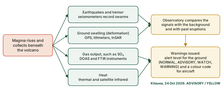
In the United States, the USGS turns these observations into a two-part warning: ranked terms for people on the ground and ranked colours to inform the aviation sector about airborne ash hazards (USGS).
USGS volcano alert levels (ground hazards)
| Level | Meaning |
|---|---|
| NORMAL | Typical background, non-eruptive state; or activity has ceased after a higher level |
| ADVISORY | Signs of elevated unrest above the known background; or activity has decreased significantly but is still watched closely |
| WATCH | Heightened or escalating unrest with increased potential of eruption, timeframe uncertain; or an eruption is under way but poses limited hazards |
| WARNING | Hazardous eruption is imminent, under way or suspected |
USGS Volcano Hazards Program, "Volcanic alert-levels characterize conditions at U.S. volcanoes". A separate aviation colour code warns aircraft; Kilauea stood at ADVISORY and YELLOW on 24 Oct 2026 (USGS Hawaiian Volcano Observatory, Kīlauea daily update, 24 Oct 2026).
In the news
Unrest is not an eruption. When the Alaska Volcano Observatory lowered Mount Spurr to NORMAL and colour code GREEN on 20 August 2025, the volcano had not erupted (USGS AVO). A forecast or a raised alert level is a statement of probability, never a record of an eruption.
The eruptions of 2024-2026
The GVP database lists the eruptions of 2024 to early 2026; the table below picks examples from each setting, and the dates are those in the database, which runs to late March 2026.
Selected eruptions of 2024-2026 in the GVP database
| Volcano | Setting (GVP) | Dates (GVP) | VEI |
|---|---|---|---|
| Ruang, Indonesia | Subduction zone | 16 Apr-7 May 2024 | 4 |
| Barren Island, India | Subduction zone | 15 Mar-29 May 2024; 30 Jul 2025-11 Jan 2026 | 2 |
| Kanlaon, Philippines | Subduction zone | 3 Jun 2024; from 19 Oct 2024, continuing in Mar 2026 | 3 |
| Kilauea, Hawaii, USA | Intraplate | 3 Jun 2024; 15-20 Sep 2024; from 23 Dec 2024 (summit) | 0; 0; 1 |
| Reykjanes (Sundhnúkagígar), Iceland | Rift zone | 1 Apr 2025; 16 Jul-5 Aug 2025 | 0 |
| East Pacific Rise at 9.8°N | Mid-ocean ridge | 28-29 Apr 2025 | 0 |
| Hayli Gubbi, Ethiopia | Rift zone | 23 Nov 2025 | 4 |
| Piton de la Fournaise, Réunion | Intraplate | 13 Feb-31 Mar 2026 | not assigned |
Smithsonian Global Volcanism Program (GVP), Volcanoes of the World, Holocene eruptions database (read 24-25 Oct 2026; entries current to late March 2026); settings: GVP Holocene volcanoes database (read 25 Oct 2026). "Continuing" = still in eruption at the last database update.
The two VEI 4 events of the period came from very different settings. Ruang, a small island stratovolcano north of Sulawesi in the Sangihe arc, erupted explosively in April and May 2024; its earlier eruptions, recorded since 1808, have often sent pyroclastic flows into inhabited areas (GVP). Hayli Gubbi, the southernmost volcano of the Erta Ale range in the Afar rift of Ethiopia, is a basaltic shield, yet on 23 November 2025 a large explosive eruption blew out its summit cone and opened a new crater about 200 m across (GVP). Far from land, an eruption on the East Pacific Rise in April 2025 was a reminder that volcanism also goes on, mostly unseen, along the mid-ocean ridges (see sea-floor spreading). In India, Barren Island erupted twice in this period.
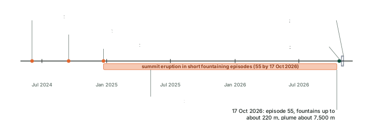
Kilauea: an eruption in episodes
Kilauea, the shield volcano that overlaps the eastern flank of Mauna Loa in Hawaii, erupted in all three of its main areas in 2024: on the Southwest Rift Zone on 3 June, at Napau Crater on the upper East Rift Zone from 15 to 20 September, and in Halemaʻumaʻu crater at the summit from 23 December (GVP).
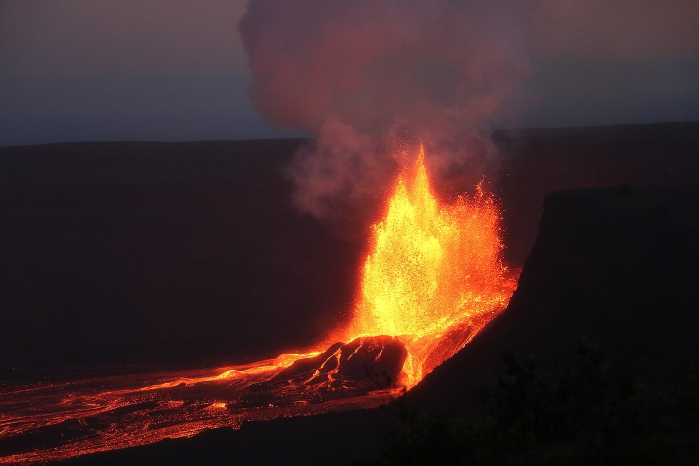
The summit eruption that began on 23 December 2024 has taken an unusual form: short episodes of lava fountaining, which the USGS Hawaiian Volcano Observatory (HVO) says generally lasted less than 12 hours, separated by pauses while the summit magma chamber refilled. Summit tiltmeters show the ground swelling during each pause, which lets HVO forecast the next episode. By October 2026 there had been 55 episodes. Episode 55, on 17 October 2026, ran from 3:19 to 9:03 a.m. local time, with fountains up to about 220 m and a plume to about 7,500 m above sea level; it was preceded by a record 39 days of intermittent overflows. As of 24 October 2026 the eruption was paused, at alert level ADVISORY and aviation colour code YELLOW. HVO's forecast of 24 October placed episode 56 between 30 October and 5 November 2026; that is a forecast, not an event.
Summary
- A volcano is a place where gas, ash and molten rock escape to the surface (NCERT). Molten rock below the surface is magma; erupted, it is lava.
- Silica controls viscosity, and viscosity controls how easily gas escapes: low-silica basalt erupts effusively, high-silica dacite and rhyolite explosively. Water meeting magma can make even a basaltic eruption explosive.
- By activity, volcanoes are active, dormant or extinct; the GVP's practical test is whether a volcano has erupted in the Holocene (the past approximately 12,000 years).
- Eruption styles run from Hawaiian and Strombolian through Vulcanian and Pelean to Plinian; phreatic eruptions are steam blasts with no new magma.
- NCERT's five types are shield, composite, caldera, flood basalt province and mid-ocean ridge volcanoes; the USGS adds cinder cones and lava domes.
- The VEI (Newhall and Self, 1982) runs from 0 to 8; above VEI 2 each step means about ten times more tephra; lava does not count.
- Most volcanoes lie on plate boundaries, above all the Pacific Ring of Fire; hotspots explain the rest.
- Climate cooling comes from stratospheric sulphate aerosols (Pinatubo 1991); Hunga Tonga 2022 added water vapour, and that layer cooled the stratosphere by about 4 K.
- Barren Island is India's only active volcano, erupting repeatedly since 1787 and most recently in 2025-26; Narcondam has no documented Holocene eruption.
- Monitoring watches earthquakes, swelling, gas and heat; Kilauea's summit eruption (since December 2024) was paused after episode 55 as of 24 October 2026.
Sources
Each table and data figure names its source beneath it. The main documents are collected here, with a date where the source carries one. Figures not listed under image credits were drawn for this page from the data and formulas stated in their source lines.
Main sources
| Topic | Source |
|---|---|
| Textbook | NCERT Class XI, Fundamentals of Physical Geography, ch. 3, The Interior of the Earth (Rationalised 2023-24) |
| Magma, lava and eruption styles | USGS glossary: magma, lava, silica; USGS, Volcanoes: eruptions |
| Volcano types | USGS, Volcanoes: types; USGS glossary, caldera; NOAA, mid-ocean ridge |
| The VEI | USGS Yellowstone Volcano Observatory, "The Volcanic Explosivity Index" (26 Dec 2022) |
| Where volcanoes occur | National Geographic, Ring of Fire; USGS, This Dynamic Earth, "Hotspots" |
| Great eruptions and climate | Self and others, Pinatubo (USGS); USGS, "Mount St. Helens: comparisons with other eruptions"; NASA, Hunga Tonga; Texas A&M University, 26 Jul 2024 |
| India's volcanoes and the eruptions of 2024-2026 | Smithsonian GVP, Barren Island; GVP Holocene eruptions database (read 24-25 Oct 2026; entries current to late March 2026) |
| Kilauea and alert levels | USGS HVO, Kilauea update, 24 Oct 2026; USGS, volcanic alert levels |
Image credits
| Image | Credit and licence |
|---|---|
| Mount St Helens, 18 May 1980 | Austin Post, USGS. Public domain. File page |
| Pinatubo eruption column, 12 Jun 1991 | Dave Harlow, USGS. Public domain. File page |
| Kilauea, episode 20, 6 May 2025 | K. Mulliken, USGS. Public domain. File page |
| Plate boundaries on maps | Bird (2003), PB2002 model, doi:10.1029/2001GC000252; GeoJSON conversion fraxen/tectonicplates, Open Data Commons Attribution License 1.0 |
| Land outlines on maps | Natural Earth, 1:110m and 1:50m vectors. Public domain. |
| All other figures | Drawn for this page from the data and formulas given in their source lines. |