 BharatNotes
Part 3 of 7 of the Plate Tectonics and Volcanism notes. The overview page has the quick revision, exam strategy, vocabulary and key terms for all seven parts.
Mapping the Ocean Floor and Sea-Floor Spreading
Wegener's evidence came from the continents. The answer to his missing mechanism came from the ocean floor, which covers about two-thirds of the planet and was almost unknown until the 20th century. When the sea bed was sounded, sampled and magnetically surveyed, it turned out to be young, rugged and striped, with a mountain chain running around the globe and deep trenches at its edges. This part follows that discovery, from echo sounding to the 1968 drill cores, and explains Hess's idea of sea-floor spreading.
Mapping the ocean floor
About two-thirds of the Earth's surface lies beneath the oceans. Before the 19th century, USGS notes, most people thought the ocean floor was flat and featureless. As early as the 16th century a few navigators, taking soundings with hand lines, found that depths could differ greatly. Deep-sea line soundings became routine in the 19th century; in 1855 a chart published by U.S. Navy Lieutenant Matthew Maury showed the first evidence of underwater mountains in the central Atlantic, which he called the "Middle Ground", later confirmed by ships laying the trans-Atlantic telegraph cable (USGS, This Dynamic Earth, "Developing the theory").
The picture sharpened after the First World War, when echo sounding arrived: a ship sends a sound signal, a "ping", to the sea floor and times how long the echo takes to return. The records showed that the ocean floor was much more rugged than anyone had thought (USGS, This Dynamic Earth, "Developing the theory"). To turn the time into depth, the two-way travel time is halved and multiplied by an assumed speed of sound in sea water, which NOAA gives as 1,500 m a second; the result is then corrected, because the speed varies with the temperature, salinity and pressure of the water (NOAA NCEI, Data Announcement 84-MGG-18, echo-sounding correction tables).
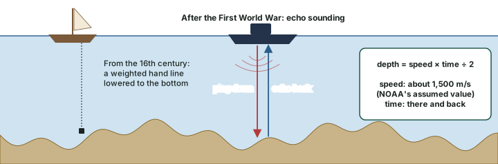
Worked example: Depth from an echo
An echo returns 6 seconds after the ping. How deep is the sea? And how long would an echo take from the Challenger Deep, about 10,935 m down?
- Sound goes down and back, so the one-way time is 6 ÷ 2 = 3 s.
- Depth = 1,500 m/s × 3 s = 4,500 m.
- Challenger Deep: time = 2 × 10,935 ÷ 1,500 = 14.6 s.
Answer: About 4,500 m, a typical deep-ocean depth (NOAA gives the average depth of the ocean as about 3,682 m); about 15 s for the deepest point.
After the Second World War, expeditions mapped the ocean floor in detail. NCERT sums up what they found: the floor is not a vast plain but is full of relief, with submerged mountain ranges and deep trenches, the trenches mostly close to the continental margins. In 1947 seismologists on the U.S. research ship Atlantis found that the sediment layer on the Atlantic floor was much thinner than expected; scientists had believed the oceans were at least 4 billion years old, so the sediment should have been very thick (USGS, This Dynamic Earth, "Developing the theory").
The relief of the ocean floor
NCERT divides the ocean floor into three major divisions by depth and form of relief: continental margins, deep-sea basins and mid-ocean ridges (diagram below). NCERT treats ocean relief in detail in a later chapter of the same book; here the point is what each part says about the movement of continents.
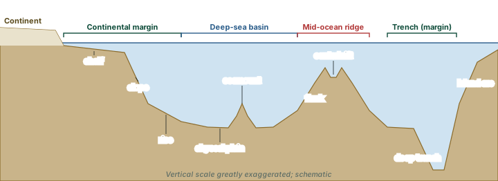
- Continental margins form the transition between continental shores and the deep-sea basins. They include the continental shelf, continental slope, continental rise and the deep-oceanic trenches. NCERT singles out the trenches as of great interest for the distribution of oceans and continents.
- Abyssal plains are extensive plains between the continental margins and the mid-oceanic ridges, where continental sediments carried beyond the margins are deposited.
- Mid-oceanic ridges form an interconnected chain of mountains within the ocean, the longest mountain chain on the earth's surface though submerged. Each has a central rift system at the crest, a fractionated plateau and a flank zone along its length. The rift at the crest is a zone of intense volcanic activity.
In the 1950s surveys by many nations showed that this mountain range virtually encircles the Earth. USGS describes it as more than 50,000 km long, more than 800 km across in places, rising an average of about 4,500 m above the sea floor, and "the most prominent topographic feature on the surface of our planet" (USGS, This Dynamic Earth, "Developing the theory"). NOAA gives its length as 40,389 miles, about 65,000 km, and notes that about 90 per cent of the system lies under the ocean (NOAA Ocean Service, "What is the longest mountain range on earth?"). The figures differ by source, so quote each with its name.
The deepest point of the oceans, the Challenger Deep, lies at the southern end of the Mariana Trench in the western Pacific. NOAA gives its depth as about 10,935 m; other surveys give slightly different values, so "about 10,900 to 11,000 m" is safe. It is named after HMS Challenger, whose crew first sounded the trench in 1875 (NOAA Ocean Service, "How deep is the ocean?"). Smaller features are still being found: from satellite data, one census estimates that over 100,000 seamounts more than 1 km high remain uncharted (Wessel, Sandwell and Kim, "The Global Seamount Census", Oceanography 23(1)).
Numbers to know
Ridge length: NOAA, 40,389 miles (computed: about 65,000 km); USGS, more than 50,000 km. Ridge height: about 4,500 m above the sea floor (USGS). Deepest point: Challenger Deep, Mariana Trench, about 10,935 m (NOAA). Iceland sits on the Mid-Atlantic Ridge and is splitting along it, between the North American and Eurasian plates (USGS, This Dynamic Earth, "Understanding plate motions").
Where earthquakes and volcanoes occur
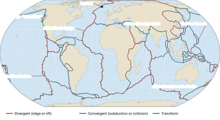
Seismographs around the world showed that earthquakes are not scattered at random. NCERT describes the pattern on its world map of earthquakes and volcanoes:
- A line of earthquakes runs through the central Atlantic, almost parallel to the coastlines, and continues into the Indian Ocean. A little south of the Indian subcontinent it bifurcates: one branch goes into East Africa, the other meets a similar line running from Myanmar to New Guinea. This line coincides with the mid-oceanic ridges.
- A second belt follows the Alpine-Himalayan system and the rim of the Pacific Ocean.
- Earthquake foci are shallow under the mid-oceanic ridges and deep-seated along the Alpine-Himalayan belt and the Pacific rim.
- Volcanoes follow a similar pattern. The rim of the Pacific is called the "rim of fire" for its active volcanoes (see the part on volcanoes).
The red and blue lines of the world map above follow these belts. USGS adds that by the late 1920s seismologists were identifying earthquake zones parallel to the trenches and inclined into the Earth; the part on plate boundaries explains these sloping zones (USGS, This Dynamic Earth, "Developing the theory").
Convection currents: a possible force
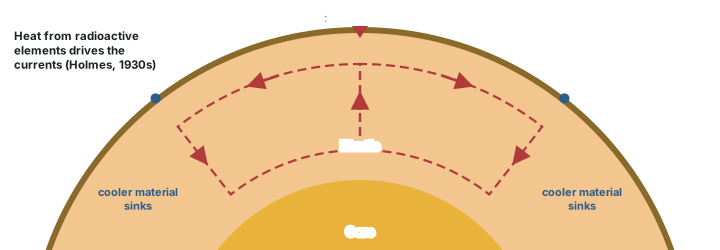
In the 1930s Arthur Holmes discussed the possibility of convection currents in the mantle. They would be generated by radioactive elements causing differences of temperature in the mantle, and Holmes argued that such a system of currents exists through the entire mantle. NCERT notes that this was an attempt to answer the question of force on which scientists had discarded drift. In such a system hot material rises, spreads and sinks again where it has cooled; currents of this kind could supply the force that drift lacked (diagram below).
Hypothesis, not settled fact
Mantle convection remains part of the explanation for plate motion, but what drives the plates is still debated, and forces acting at the edges of the plates are also proposed. Write convection as a proposed driving force, not as a settled fact. The part on plate boundaries sets out the competing ideas.
Hess and sea-floor spreading
The mapping of the ocean floor and the palaeomagnetic study of its rocks revealed facts that were not available to Wegener. NCERT lists five:
What the ocean floor revealed
| Observation (NCERT) | What it suggests | |
|---|---|---|
| (i) | Volcanic eruptions are common all along the mid-oceanic ridges and bring huge amounts of lava to the surface. | New crust is being made at the ridges. |
| (ii) | Rocks equidistant on either side of a ridge crest are remarkably similar in age, chemistry and magnetic properties. Rocks nearest the ridge have normal polarity and are the youngest; age increases away from the crest. | Crust forms at the crest and moves away symmetrically. |
| (iii) | Ocean crust rocks are much younger than continental rocks: nowhere more than 200 million years old, while some continental rocks are 3,200 million years old. | Ocean floor is continually renewed and destroyed. |
| (iv) | Sediments on the ocean floor are unexpectedly thin, and nowhere is the sediment column older than 200 million years. | The floor has not been there long enough to collect thick sediment. |
| (v) | Deep trenches have deep-seated earthquakes; under the ridges the foci are shallow. | Crust sinks into the mantle at trenches. |
NCERT, Fundamentals of Physical Geography, Class XI, chapter 4 "Distribution of Oceans and Continents" (Reprint 2025-26 edition)
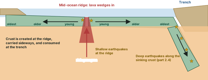
These facts, and a detailed analysis of the magnetism of rocks on either side of the ridges, led Harry Hess to propose sea-floor spreading. In NCERT's words, Hess argued that "constant eruptions at the crest of oceanic ridges cause the rupture of the oceanic crust and the new lava wedges into it, pushing the oceanic crust on either side. The ocean floor, thus spreads." Since the spreading of one ocean does not shrink another, he concluded that ocean floor pushed away from the ridges sinks at the trenches and is consumed (diagram below).
USGS puts the problem Hess solved this way. Most geologists believe the Earth has changed little in size since it formed 4.6 billion years ago, and an "expanding Earth" was rejected for want of a mechanism. So if crust is added along the ridges, it must be destroyed elsewhere. Hess suggested that new crust spreads away from the ridges in a conveyor-belt-like motion and eventually descends into the trenches; the Atlantic was expanding while the Pacific was shrinking, and the ocean basins were perpetually being "recycled". The idea explained why the Earth does not grow, why there is so little sediment on the ocean floor, and why oceanic rocks are much younger than continental ones (USGS, This Dynamic Earth, "Developing the theory").
Who and when. Hess, a Princeton University geologist and U.S. Naval Reserve Rear Admiral, announced the idea in 1960 and published it in 1962 as "History of Ocean Basins" (in a Geological Society of America volume in honour of A. F. Buddington, pages 599-620). NCERT dates it "Hess (1961)". The term sea-floor spreading was coined by Robert S. Dietz, then at the U.S. Navy Electronics Laboratory in San Diego, in a paper in Nature in June 1961 (R. S. Dietz (1961), "Continent and Ocean Basin Evolution by Spreading of the Sea Floor", Nature 190: 854-857, doi:10.1038/190854a0; USGS, This Dynamic Earth, "Developing the theory").
Exam tip
For NCERT-based answers, "Hess (1961)" is the year to write; know that the paper appeared in 1962. Pair the names correctly: Holmes, convection currents (1930s); Hess, sea-floor spreading; Dietz, the term; Vine and Matthews, the magnetic test (next section).
Palaeomagnetism and the magnetic stripes
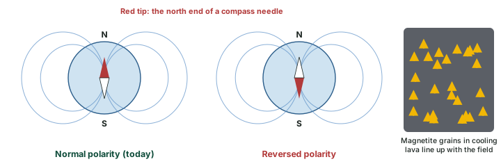
The rock of the ocean floor, basalt, is an iron-rich volcanic rock containing a strongly magnetic mineral, magnetite; Icelandic mariners noticed it disturbing their compasses as early as the late 18th century. Magnetite grains behave like little magnets and line up with the Earth's magnetic field; when magma cools to solid rock, their alignment is "locked in", recording the polarity at the time of cooling (USGS). Early in the 20th century, Bernard Brunhes in France (1906) and Motonari Matuyama in Japan (1920s) recognised that rocks fall into two groups: normal polarity, matching today's field, and reversed polarity, the opposite. The Earth's magnetic field has flipped many times (USGS, This Dynamic Earth, "Developing the theory"). The part on the interior of the Earth explains where the field comes from: motion in the liquid outer core.
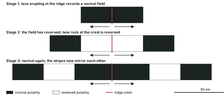
From the 1950s, scientists using magnetometers, adapted from airborne devices built in the Second World War to detect submarines, found that the ocean floor's magnetism forms a zebra-like pattern: alternating stripes of normal and reversed rock laid out in rows on both sides of the mid-ocean ridge (USGS, This Dynamic Earth, "Developing the theory"). Sea-floor spreading explains it at once (diagram below). Lava erupting at the crest records the field of its day, then is split and carried away on both sides as newer lava erupts. Each reversal starts a new stripe at the crest, so the stripes form in mirror-image pairs about the ridge, and the ocean floor becomes a natural "tape recording" of the history of reversals (USGS).
In 1963 Frederick Vine and Drummond Matthews showed that the magnetic anomalies over an oceanic ridge could be explained in this way (F. J. Vine and D. H. Matthews (1963), "Magnetic Anomalies Over Oceanic Ridges", Nature 199: 947-949, doi:10.1038/199947a0). Lawrence Morley proposed the same idea independently. Their paper was the first test of sea-floor spreading, not its final proof; the clinching evidence came from drilling in 1968 (next section).
Don't confuse: Vine and Matthews vs Glomar Challenger
Vine and Matthews (1963) tested sea-floor spreading with magnetic stripes: the first test, a strong argument. Glomar Challenger (1968) drilled the ocean floor and dated the cores: USGS calls this "the clinching evidence". Do not call Vine-Matthews the "conclusive proof".
The age of the ocean floor and deep-sea drilling
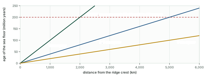
If the floor spreads from the ridges, rock should get older with distance from the crest. NCERT states the result: rocks nearest the ridges are the youngest, age increases away from the crest, and ocean crust is nowhere older than 200 million years, while some continental rocks are 3,200 million years old. At a steady spreading rate the age of the floor grows in direct proportion to distance (graph below).
Worked example: How old is the floor here?
A sample is taken 1,000 km from a ridge crest. If the sea floor on that side has moved away at 2.5 cm a year, how old is the rock?
- Convert: 1,000 km = 100,000,000 cm.
- Age = 100,000,000 cm ÷ 2.5 cm a year = 40,000,000 years.
- So the rock formed at the crest about 40 million years ago.
Answer: About 40 million years. Reverse the sum and you can find a spreading rate from a dated sample or a dated magnetic stripe.
The test came from an unexpected source, petroleum exploration. Oil companies had built ships with drilling rigs able to carry kilometres of drill pipe, and the idea was adapted for a research vessel, the Glomar Challenger, designed to collect drill cores from the deep ocean floor. In 1968 it set out on a year-long expedition, criss-crossing the Mid-Atlantic Ridge between South America and Africa and drilling cores at chosen sites. When the ages of the samples were found by palaeontological and isotopic dating, USGS says, "they provided the clinching evidence that proved the seafloor spreading hypothesis" (USGS, This Dynamic Earth, "Developing the theory"). NCERT names two drilling programmes of this kind, the Deep Ocean Drilling Project and the Integrated Ocean Drilling Project (see the part on the interior of the Earth).
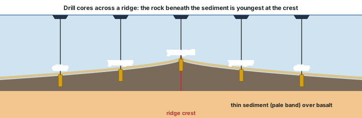
Older than 200 million years?
Is any ocean floor older than 200 million years? Oceanic crust in the main ocean basins is no older than about 200 million years (NCERT). One 2016 study claims that a fragment of much older, Palaeozoic oceanic crust survives beneath the eastern Mediterranean (R. Granot (2016), "Palaeozoic oceanic crust preserved beneath the eastern Mediterranean", Nature Geoscience 9: 701-705, doi:10.1038/ngeo2784); the claim is not settled. For continents, the Acasta Gneiss of Canada is about 4 billion years old (LibreTexts, Historical Geology, a secondary text), older than the 3,200 million years NCERT quotes.
Pillow lava and hydrothermal vents
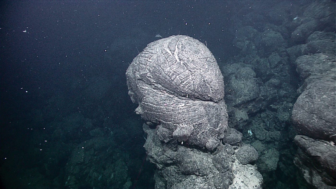
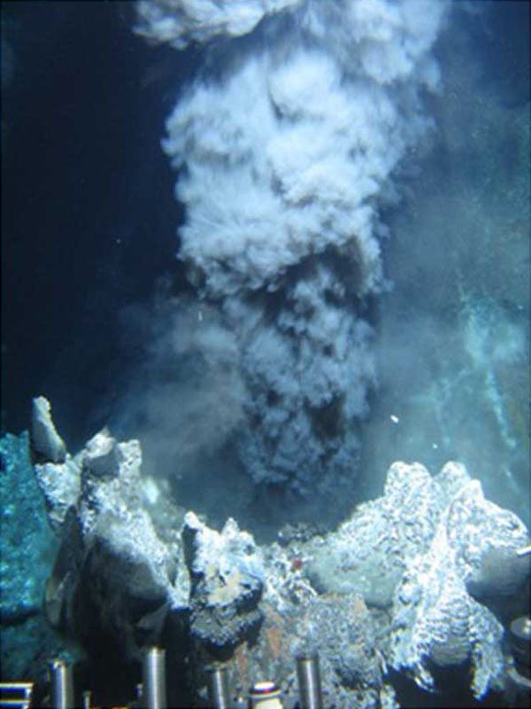
Photographs taken on the ridges show two features. Where lava erupts under water at the crest, it forms rounded, cushion-like masses called pillow lava; the part on volcanic landforms explains how they form. And where sea water meets the hot rock of the ridge, hydrothermal vents appear.
NOAA explains that hydrothermal vents form "at locations where seawater meets magma". Underwater volcanoes at spreading ridges and convergent plate boundaries produce these hot springs: cold sea water percolates down through fissures in the ocean crust, is heated by hot magma, and re-emerges at the vents. Vent water may reach over 700° Fahrenheit (computed: about 371°C). "Black smokers" are chimneys built of iron sulfide, which is black, and the vents support communities of organisms that depend on the chemistry of sea water and hot rock, many of them unknown before the vents were found (NOAA Ocean Service, "What is a hydrothermal vent?" (updated 23 Sep 2026)).
From mapping to proof
| When | What | Source |
|---|---|---|
| 1855 | Maury's chart shows the "Middle Ground" in the central Atlantic | USGS |
| After 1918 | Echo sounding reveals a rugged ocean floor | USGS |
| 1906; 1920s | Brunhes and Matuyama: rocks have normal or reversed polarity | USGS |
| 1930s | Holmes: convection currents in the mantle | NCERT |
| 1947 | Atlantis finds the Atlantic sediment unexpectedly thin | USGS |
| 1950s | The global mid-ocean ridge is traced; magnetic stripes found | USGS |
| 1960-62 | Hess: sea-floor spreading (NCERT: 1961) | USGS; NCERT |
| 1961 | Dietz coins the term "sea-floor spreading" | Nature |
| 1963 | Vine and Matthews: first magnetic test | Nature |
| 1968 | Glomar Challenger drill cores: the clinching evidence | USGS |
USGS, This Dynamic Earth, "Developing the theory"; NCERT, Fundamentals of Physical Geography, Class XI, chapter 4 "Distribution of Oceans and Continents" (Reprint 2025-26 edition); R. S. Dietz (1961), "Continent and Ocean Basin Evolution by Spreading of the Sea Floor", Nature 190: 854-857, doi:10.1038/190854a0; F. J. Vine and D. H. Matthews (1963), "Magnetic Anomalies Over Oceanic Ridges", Nature 199: 947-949, doi:10.1038/199947a0.
Summary
Summary: the floor
- Echo sounding (after 1918) and post-war surveys showed a rugged floor: margins, abyssal plains, a global ridge and deep trenches.
- Earthquakes follow the ridges (shallow) and the Pacific rim and Alpine-Himalayan belt (deep).
- Holmes (1930s) proposed mantle convection, still debated as the driver.
Summary: spreading
- Hess: crust forms at ridges and sinks at trenches; Dietz named it (1961).
- Mirror-image magnetic stripes: first test by Vine and Matthews (1963); 1968 drill cores clinched it.
- Ocean floor is nowhere older than about 200 million years (NCERT); pillow lava and vents mark the active ridges.
Sources
Each table and data figure names its source beneath it. The main documents are collected here, with a date where the source carries one. Figures not listed under image credits were drawn for this page from the data and formulas stated in their source lines.
Main sources
| Topic | Source |
|---|---|
| Textbook | NCERT Class XI, Fundamentals of Physical Geography, ch. 4, Distribution of Oceans and Continents (Reprint 2025-26 edition) |
| Ocean floor and spreading | USGS, Developing the theory; USGS, Understanding plate motions; Dietz (1961); Vine and Matthews (1963); NOAA, mid-ocean ridge; NOAA, hydrothermal vents (updated 23 Sep 2026) |
| Ocean depth and the sea bed | NOAA NCEI, Data Announcement 84-MGG-18; NOAA Ocean Service, "How deep is the ocean?"; Wessel, Sandwell and Kim, "The Global Seamount Census" |
| Old oceanic crust | R. Granot (2016), Nature Geoscience 9: 701-705 |
| Plate boundaries on the world map | Bird (2003), "An updated digital model of plate boundaries", Geochemistry, Geophysics, Geosystems 4(3), 1027 |
Image credits
| Image | Credit and licence |
|---|---|
| Pillow lava, Galápagos Rift, 2011 | NOAA. Public domain. File page |
| Black smoker, Endeavour hydrothermal vents, 2009 | NOAA. Public domain. File page |
| World map: plate boundaries | Bird (2003), PB2002 model, doi:10.1029/2001GC000252; GeoJSON conversion fraxen/tectonicplates, Open Data Commons Attribution License 1.0 |
| Land outlines on maps | Natural Earth, 1:110m and 1:50m vectors. Public domain. |
| All other figures | Drawn for this page from the data and formulas given in their source lines. |