 BharatNotes
Part 7 of 9 of the Soils and Biogeography notes. The overview page has the quick revision and exam strategy for all nine parts.
Biogeographic Realms and Boundary Lines
Part 4.6 sorted the living world by climate. This part sorts it a second way, by history: two places can share a climate and a biome yet hold quite different animals, because their pasts differ. It traces how naturalists from Sclater and Wallace to the 2017 ecoregion map drew the world's realms, what their boundaries follow, and why one boundary in the Malay Archipelago, Wallace's Line, became iconic.
Two ways to divide the living world
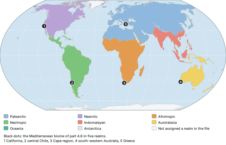
A biome groups places by the kind of vegetation their climate allows (biosphere and biomes). A biogeographic realm groups them by the animals and plants they share through common history: which groups evolved there, and which could or could not cross the seas, mountains and deserts in between. The two maps cut across each other. The clearest proof is the Mediterranean biome. Part 4.6 found it in five places with the same climate; on the realm map those five places fall in five different realms (see the map below): California (Nearctic), central Chile (Neotropic), the Cape region of South Africa (Afrotropic), south-western Australia (Australasia) and Greece (Palearctic). One climate, five histories.
Key idea
Biome = climate; realm = history. A biome repeats wherever the climate repeats. A realm does not repeat: each covers its own part of the world, because it records where groups of animals and plants evolved and how far they could spread.
Sclater and Wallace: six regions
The first lasting division came from birds. In 1858 P.L. Sclater divided the world by the distribution of birds into six regions: Palaearctic, Aethiopian, Indian, Australian, Nearctic and Neotropical. His own headings show how he thought of them, as the old world's tropics split three ways and the new world's tropics on their own: the "Aethiopian or Western Palaeotropical Region", the "Indian or Middle Palaeotropical Region" and the "Neotropical or South-American Region".
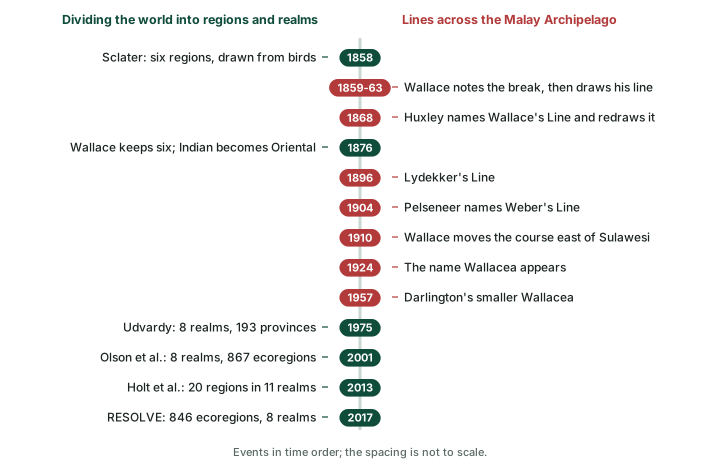
A.R. Wallace took Sclater's scheme into the study of all animals. His two-volume The Geographical Distribution of Animals (1876) has a section headed "Reasons for adopting the Six Regions first proposed by Mr. Sclater". Wallace kept the six but renamed Sclater's Indian region the Oriental region, giving the list Palaearctic, Ethiopian, Oriental, Australian, Neotropical and Nearctic. In his list of Sclater's regions the Indian region runs "to South China, and to Borneo and Java", and the Australian region is given as "including Celebes and Lombock, eastward to Australia and the Pacific Islands". Wallace therefore had no separate region for the Pacific islands or for Antarctica (see the diagram below). His own world map of the zoogeographical regions, from the German edition of 1876, is shown after it.
Udvardy, Olson and RESOLVE: eight realms
The eight-realm scheme used on most modern maps is not Wallace's. It comes from M.D.F. Udvardy's A Classification of the Biogeographical Provinces of the World, published by IUCN in 1975 as Occasional Paper 18, which set out 8 realms and 193 provinces. The foreword states the change plainly: a division of the "world's terrestrial and freshwater lake biota into 8 realms in place of the earlier 7 biogeographical regions. Oceania is given realm status, the Antarctic is extended to include New Zealand, the Australian contracted to Australia-Tasmania and coastal islands, the Palaearctic and Nearctic are extended southward." Udvardy also brought in new names, Africotropical and Indomalayan, in place of Ethiopian and Oriental. The foreword does not list the "earlier 7" regions it mentions, while Sclater and Wallace had six.
The world ecoregion map of Olson et al. (2001) built on this. Its authors wrote: "We began by accepting the biogeographic realms of Pielou (1979) and Udvardy (1975)", and placed each of their 867 ecoregions in one of eight realms. The 2017 update by Dinerstein et al. (the RESOLVE map) kept the idea: its data file assigns each of its 846 ecoregions to one of eight realms, the file drawn in the realm map above. One change between the schemes is easy to miss: New Zealand sits in the Antarctic realm in Udvardy (1975) but in Australasia in the 2001 and 2017 maps (point check on the 2017 file).
Remember
Sclater (1858) and Wallace (1876) had six regions. The eight realms, with Oceania and Antarctica added, are Udvardy's (1975), later used by Olson et al. (2001) and the 2017 map. Never credit Wallace with eight realms.
One realm, four names: the realms across the schemes
| Sclater (1858) | Wallace (1876) | Udvardy (1975) | 2017 data file (RESOLVE) |
|---|---|---|---|
| Palaearctic | Palaearctic | Palaearctic | Palearctic |
| Aethiopian | Ethiopian | Africotropical | Afrotropic |
| Indian | Oriental | Indomalayan | Indomalayan |
| Australian | Australian | Australian (Australia-Tasmania and coastal islands) | Australasia |
| Nearctic | Nearctic | Nearctic | Nearctic |
| Neotropical | Neotropical | Neotropical | Neotropic |
| none | none | Oceanian | Oceania |
| none | none | Antarctic (with New Zealand) | Antarctica |
Source: Sclater (1858): Sclater, P.L. (1858), "On the general geographical distribution of the members of the class Aves", J. Proc. Linnean Soc. Zoology 2: 130-145 (transcription, C.H. Smith, WKU). Wallace (1876): Wallace, A.R. (1876), The Geographical Distribution of Animals, vol. 1 (Internet Archive). Udvardy (1975), foreword: Udvardy, M.D.F. (1975), A Classification of the Biogeographical Provinces of the World, IUCN Occasional Paper 18. Realm names as spelt in the RESOLVE 2017 file (Dinerstein et al. (2017), "An ecoregion-based approach to protecting half the terrestrial realm", BioScience 67: 534-545). The names line up row by row; the boundaries behind them do not.
Holt et al. (2013): eleven realms
Realm maps are still being redrawn. In 2013 Holt and colleagues published "An update of Wallace's zoogeographic regions of the world" in Science. Instead of birds alone, they used the distributions of 21,037 species of amphibians, birds and mammals. Their abstract reports: "We identify 20 distinct zoogeographic regions, which are grouped into 11 larger realms." Three numbers therefore circulate for the "same" idea, and each belongs to a different scheme.
- 6 regions: Sclater (1858, birds), kept by Wallace (1876)
- 8 realms: Udvardy (1975), used by Olson et al. (2001) and the 2017 map
- 11 realms grouping 20 regions: Holt et al. (2013), from 21,037 species
Where the boundaries fall, and why history matters
Point checks on the 2017 file show where three famous boundaries run (see the table below).
- The Himalaya. Leh (Ladakh), Lhasa and Kabul fall in the Palearctic realm; Delhi, Kathmandu and Shillong (Meghalaya) fall in the Indomalayan. Two more Indian places checked, Chennai (Tamil Nadu) in the south and Jaisalmer (Rajasthan) in the Thar, are Indomalayan too; of the Indian places checked, only Leh is Palearctic.
- The Sahara. Cairo and Tamanrasset are Palearctic; Timbuktu and Khartoum are Afrotropic. On the 2017 file the switch from Palearctic to Afrotropic, checked along the 0, 10, 20 and 30 degree E meridians, comes between about 17 and 20 degrees N, exactly where the desert biome gives way to tropical grasslands and savannas (computed). Tamanrasset lies in the desert biome, Timbuktu and Khartoum in the grassland biome. Here the realm boundary and the biome boundary run together; around the Mediterranean-climate regions met at the start of this part they do not.
- Mexico. Monterrey and Mexico City are Nearctic; Panama is Neotropic.
Places checked against the 2017 realm file
| Realm (2017 file) | Places checked in this part | Matching name in Wallace (1876) |
|---|---|---|
| Palearctic | Leh (Ladakh), Lhasa, Kabul, Beijing, Riyadh, Cairo, Tamanrasset | Palaearctic |
| Indomalayan | Delhi, Chennai (Tamil Nadu), Shillong (Meghalaya), Jaisalmer (Rajasthan), Kathmandu, Karachi, Sri Lanka, Malay Peninsula, Sumatra, Java, Bali, Borneo, Luzon, Mindanao | Oriental |
| Afrotropic | Timbuktu, Khartoum, Madagascar | Ethiopian |
| Australasia | Lombok, Flores, Timor, Sulawesi, Seram, New Guinea, northern Australia, New Zealand, New Caledonia | Australian |
| Nearctic | Monterrey, Mexico City | Nearctic |
| Neotropic | Panama, the central Amazon | Neotropical |
| Oceania | Hawaii, Fiji | no separate region (his Australian region took in "the Pacific Islands") |
| Antarctica | none checked here | no separate region |
Source: Point-in-polygon tests on the simplified RESOLVE 2017 realm file, run when these notes were built (computed): Dinerstein et al. (2017), "An ecoregion-based approach to protecting half the terrestrial realm", BioScience 67: 534-545. Wallace's names: Wallace, A.R. (1876), The Geographical Distribution of Animals, vol. 1 (Internet Archive).
Why should history, rather than climate, draw these lines? Part of the answer is that the continents themselves have moved. NCERT records that Alfred Wegener put forward his continental drift theory in 1912, and explains that "Pangaea first broke into two large continental masses as Laurasia and Gondwanaland forming the northern and southern components respectively". Fossils carry the evidence. NCERT describes Mesosaurus as "a small reptile adapted to shallow brackish water" whose skeletons are found in only two places, the southern Cape of South Africa and Brazil, "presently 4,800 km apart". It also notes that the Gondwana system of sediments of India has counterparts in six different landmasses of the Southern Hemisphere. Animals that evolved on one landmass, cut off from others by ocean, give a realm its character; where landmasses met, or sea level fell enough to join islands, animals could cross. The Malay Archipelago shows both at once.
The lines of the Malay Archipelago
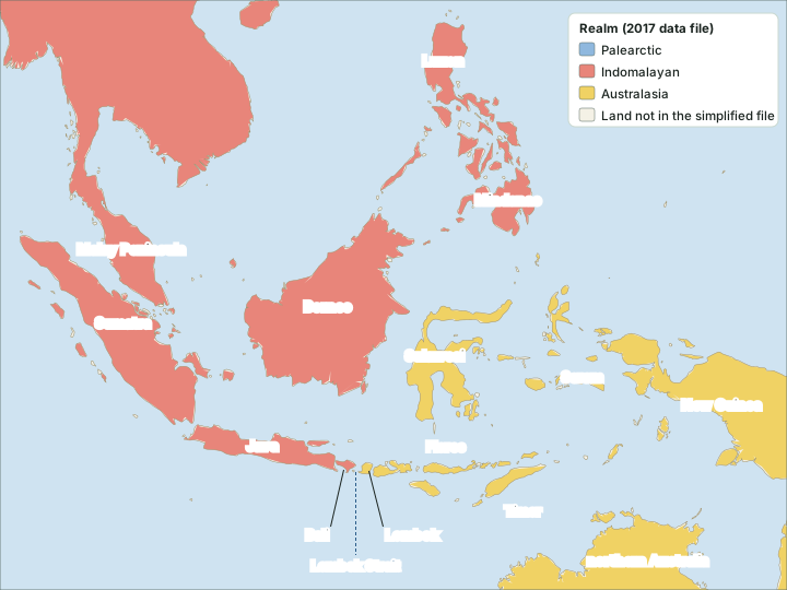
Between mainland Asia and Australia lie the many islands of the Malay Archipelago. Here the Indomalayan and Australasian realms meet, and here naturalists drew a whole family of boundary lines (see the map, the diagram and the table below).
Wallace's Line. Wallace described the break between an Asian and an Australian fauna from 1859 (a paper read on 3 November 1859 and printed in 1860), and published a drawn line in 1863 in volume 33 of the Journal of the Royal Geographical Society. Ali and Heaney (2021) describe that line as "based upon land-mammal and land-bird distributions" and note that it "has since achieved iconic status". In 1910 Wallace changed it: "its path around Sulawesi was transferred from the west to the east of the Island".
Huxley's Line. The name "Wallace's Line" is not Wallace's own. In 1868 Huxley, in the words of Esselstyn et al. (2010), "simultaneously named and modified Wallace's Line". Huxley, also working mainly from birds and mammals, "was the first to note that Palawan's fauna is Asian", and his version of the line places Palawan with Asia, "separating it from the oceanic Philippines". Ali and Heaney go further: "Ideally, Huxley's divide (1868) should carry his name rather than Wallace's; the latter never accepted the proposition."
Weber's Line is the line of faunal balance between Asian and Australian animals: Asian animals are in the majority to its west and Australian animals to its east. It was named by Pelseneer in 1904 after the zoologist Max Weber. Lydekker's Line (1896) marks the western edge of the Sahul Shelf, the shelf of Australia and New Guinea. Ali and Heaney suggest that it "ought to be labelled the Heilprin-Lydekker Line in recognition of Angelo Heilprin's 1887 contribution."
Wallacea is the name for the islands between the Sunda and Sahul shelves: Sulawesi, the Lesser Sundas and the Moluccas. The name dates from 1924. Its original form also took in the Philippines except Palawan; the smaller form that leaves out the Philippines, set out by Darlington in 1957, is the one in common use. Esselstyn et al. describe the layout from west to east: the Sunda Shelf, then the oceanic islands of Wallacea, then the Sahul Shelf of Australia and New Guinea.
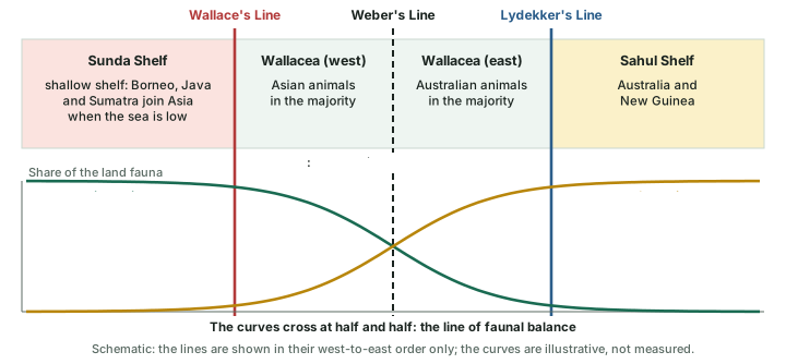
The lines of the Malay Archipelago compared
| Line | Year | Who | What it marks |
|---|---|---|---|
| Wallace's Line | 1859-63 (course changed 1910) | Wallace; named by Huxley in 1868 | The break between Asian and Australian faunas, drawn from land mammals and land birds |
| Huxley's Line | 1868 | Huxley | Wallace's Line modified: Palawan on the Asian side; marks the extent of Sundaland |
| Weber's Line | 1904 (name) | Named by Pelseneer after Max Weber | The line of faunal balance between Asian and Australian animals |
| Lydekker's Line | 1896 | Lydekker (Heilprin-Lydekker Line, Ali and Heaney 2021) | The western edge of the Sahul Shelf (Australia-New Guinea) |
| Wallacea (a zone, not a line) | 1924 (name); 1957 (smaller form) | Darlington (smaller form) | The islands between the Sunda and Sahul shelves: Sulawesi, Lesser Sundas, Moluccas |
Source: Ali and Heaney (2021), Biological Reviews 96: 922-942 (abstract, Europe PMC, PMID 33502095); Esselstyn et al. (2010), "Integrating phylogenetic and taxonomic evidence illuminates complex biogeographic patterns along Huxley's modification of Wallace's Line", J. Biogeography 37: 2054-2066.
The Lombok Strait: why deep water mattered
The Sunda Shelf, which Esselstyn et al. call "the largest continental shelf in the world", is a shallow sea floor that extends south and east from the Malay Peninsula. In times of low sea level it was exposed again and again as dry land, and Borneo, Java and Sumatra were joined into one continental landmass; its land animals are therefore Asian. The edge of the shelf lies close to the 120 m depth line, and the low sea level usually inferred for the most recent glacial maximum is also about 120 m below today's. Whatever lies shallower than that could have become land; whatever lies deeper stayed sea.
The point of Wallace's Line is deep water that stayed sea even at glacial low sea level. Susanto et al. (2024) give the measurements of the Lombok Strait: its north entrance is 1,200 m deep and 35 km wide, and its sill (the shallowest crossing) is 300 m deep and 22 km wide. In the 2017 realm file, Bali falls in the Indomalayan realm and Lombok in Australasia (see the map above). Wallace had already seen the effect in birds: in The Geographical Distribution of Animals he lists bird genera that "have reached Lombok across the narrow strait from Baly, but have passed no further".
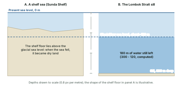
Worked example: How much water was left over the Lombok sill?
The Lombok Strait sill is 300 m deep today. If the glacial sea level stood about 120 m below today's, how deep was the water over the sill?
- Depth of the sill below today's sea level: 300 m.
- Fall in sea level at the glacial maximum: about 120 m.
- Water left over the sill: 300 - 120 = 180 m.
Answer: About 180 m of water still separated the islands, so animals that cannot cross open sea stayed on their own side (arithmetic on rounded figures, not a measured depth).
Why it happens
A shallow sea is a temporary barrier: when ice sheets grow and sea level falls, it turns into land and animals walk across. A deep strait is a lasting barrier. Wallace's Line follows deep water, so the faunas on its two sides stayed apart through the glacial cycles.
The same reasoning can be tested further north. Palawan is cut off from Borneo today by a channel that Esselstyn et al. give as about 140 m deep. Older reconstructions put the low sea level of the second-last glacial period near -140 m, which would have joined the two islands; the most recent estimates, the same paper notes, suggest they were not joined then, with sea level nearer the -120 m of the last glacial maximum.
Don't confuse
6, 8 or 11? Six regions belong to Sclater and Wallace, eight realms to Udvardy and the WWF/RESOLVE maps, eleven realms to Holt et al. (2013). Wallace's Line or Huxley's? Wallace drew the line; Huxley named it and moved Palawan to the Asian side. New Zealand? Antarctic realm in Udvardy (1975), Australasia in the 2001 and 2017 maps.
Exam tip
Learn each line as a set of three facts: who, when, and what it marks. Then add one reason for each: Wallace's Line follows deep water, Weber's Line is a balance point, Lydekker's Line is a shelf edge. Check the name, the year and the meaning of any statement separately: each can be wrong on its own.
Summary
- A biome is set by climate and repeats across continents; a realm is set by shared history and does not repeat. The Mediterranean biome falls in five different realms.
- Sclater (1858) drew six regions from birds; Wallace (1876) kept them and renamed the Indian region Oriental.
- Udvardy (1975, IUCN) set out 8 realms and 193 provinces, adding Oceania and an Antarctic realm that took in New Zealand; Olson et al. (2001) and the 2017 map use eight realms, with New Zealand in Australasia.
- Holt et al. (2013) found 20 regions in 11 realms from 21,037 species of amphibians, birds and mammals.
- Of the Indian places checked, Delhi, Chennai, Shillong and Jaisalmer are Indomalayan; Leh (Ladakh) is Palearctic.
- Wallace noted the break in 1859-63; Huxley named and redrew the line in 1868; Lydekker's Line (1896) marks the Sahul Shelf edge; Pelseneer named Weber's Line of faunal balance in 1904; Wallacea (named 1924) lies between the shelves.
- The Lombok Strait sill is 300 m deep, so about 180 m of water remained even when the sea fell about 120 m (computed).
Sources
Each table and data figure names its source beneath it. The main documents are collected here, with a date where the source carries one. Figures not listed under image credits were drawn for this page from the sources stated in their source lines.
Main sources
Image credits
| Image | Credit and licence |
|---|---|
| Alfred Russel Wallace, about 1895 (first published in Borderland Magazine, April 1896) | London Stereoscopic and Photographic Company (active 1855-1922). Public domain. File page |
| Wallace's world map of the zoogeographical regions (1876), German edition | Alfred Russel Wallace. Public domain. File page |
| All other figures | Drawn for this page from the sources given in their source lines. |



