 BharatNotes
Part 6 of 9 of the Soils and Biogeography notes. The overview page has the quick revision and exam strategy for all nine parts.
The Biosphere and the World's Biomes
The soils of the first five parts of these notes carry the living world. This part climbs the ladder of life from a single organism to the whole biosphere, then looks closely at the biome: the largest community of plants and animals that a climate can support. It sets out the two ways an aspirant must know the biomes, NCERT's five major biomes and the 14 terrestrial biomes of the WWF/RESOLVE scheme that most world maps use, and describes each one's climate, vegetation, animals and soil. It ends with mountains, India's own forest types and the evidence that biomes and species are already moving as the climate warms.
The biosphere and its building blocks
The Earth's environment is usually described as three non-living spheres, the lithosphere, the atmosphere and the hydrosphere, with life woven through all three. NCERT puts it simply: "The biosphere includes all the living components of the earth." It consists of all plants and animals, including the micro-organisms, and their interactions with their surroundings. The study of these interactions is ecology. NCERT credits the word to the German zoologist Ernst Haeckel, who, it says, "used the term as 'oekologie' in 1869". Haeckel's own first printed use is three years earlier: the word appears as "Oecologie" in his Generelle Morphologie der Organismen, vol. 2 (1866), in the section "Oecologie und Chorologie" (p. 286).
Ecologists break the biosphere into nested levels, each one a larger and more complex unit than the one inside it (diagram below). An organism is a single living individual. A population is all the individuals of one species in an area. A community is all the populations living together there. An ecosystem adds the non-living surroundings: NCERT defines it as "A system consisting of biotic and abiotic components", in which "All these components in ecosystem are inter related and interact with each other." The biotic parts are the producers (green plants, which make their own food by photosynthesis), the consumers and the decomposers; the abiotic parts are rainfall, temperature, sunlight, atmospheric humidity, soil conditions and inorganic substances such as carbon dioxide, water and nitrogen. A biome is the largest community of all, and the biosphere is the sum of them.
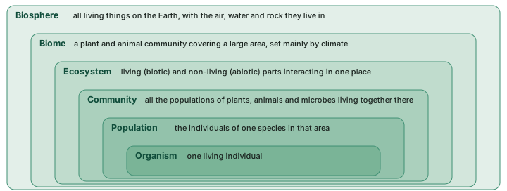
Two more words complete the vocabulary. A habitat is where a plant or animal lives. NCERT gives it two ways: the glossary of the current Class XI Fundamentals of Physical Geography calls it the "Location where a plant or animal lives", while chapter 15 of the older book defines a habitat "in the ecological sense" as "the totality of the physical and chemical factors that constitute the general environment". A niche is narrower: it is the role a species plays within its habitat, what it eats, what eats it and the conditions it needs. Two species can share a habitat while holding different niches.
Don't confuse
Habitat vs niche vs ecosystem. The habitat is the address (a pond, a forest floor); the niche is the profession (a grazer, a predator, a decomposer); the ecosystem is the whole working system of living and non-living parts in that place. Ecosystems, NCERT adds, are of two major types, terrestrial and aquatic, and the terrestrial ones are classified into biomes.
What a biome is
NCERT's definition is the one to learn first: "A biome is a plant and animal community that covers a large geographical area. The boundaries of different biomes on land are determined mainly by climate." It adds that a biome is "the total assemblage of plant and animal species interacting within specific conditions", and that these conditions include "rainfall, temperature, humidity and soil conditions". The current glossary puts it as the "Largest recognisable assemblage of animals and plants on the Earth. The distribution of the biomes is controlled mainly by climate."
How many biomes are there? The answer depends on whose scheme is used. NCERT's text names forest, grassland, desert and tundra as major biomes, and its Table 15.1 sets out five major biomes: forest, desert, grassland, aquatic and altitudinal, each split into sub-types. The scheme used on most world maps today comes from the conservation organisation WWF. Olson et al. (2001) divided the land into 867 ecoregions and grouped them into 14 biomes and 8 realms. Dinerstein et al. (2017), working with the organisation RESOLVE, revised the map to 846 ecoregions in the same 14 biomes. The number 14 is WWF's count, not a law of nature: Udvardy (1975) also used 14 "biome types", but a different list.
Don't confuse
Biome vs ecoregion vs realm. A biome groups places by the kind of vegetation the climate allows: tropical rainforest in Brazil, the Congo basin and the Western Ghats all belong to one biome although their species differ. A realm groups places by evolutionary history: the animals and plants that share an ancestry because the land was connected (biogeographic realms). An ecoregion is the small unit inside both: one biome within one realm. In the 2017 data file, every ecoregion carries one biome code and one realm code.
Climate as the master control
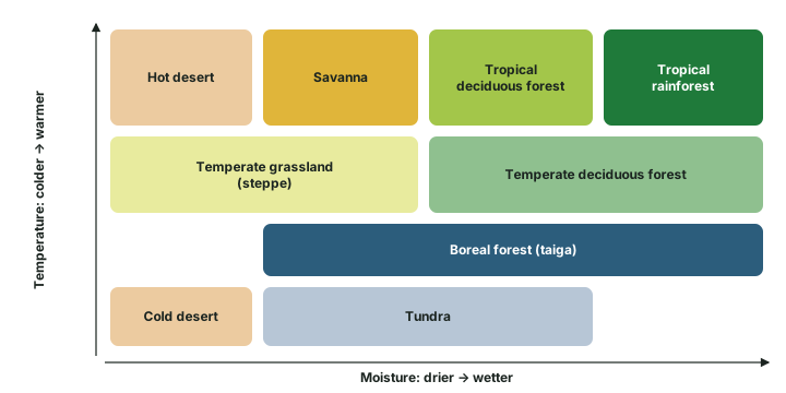
If biome boundaries are "determined mainly by climate", which parts of climate matter most? Two do: heat and water. Temperature sets the length of the growing season and whether frost kills tender tissue; moisture sets how much leaf a plant can afford to grow before it dries out. Put the two together and the biomes fall into order (diagram below). Where it is hot and wet all year, forest is tall and evergreen. Keep the heat but shorten the wet season and the forest becomes deciduous, then opens into savanna, then gives way to desert. At the cold end, the same sequence runs from boreal forest to tundra and cold desert. Ecologists often draw this as a chart of temperature against precipitation; the version here is a simplified sketch built on the ranges NCERT gives (see the major biomes below).
Why it happens
Climate also shapes the soil, so biome and soil travel together. Heavy rain and heat leach tropical soils (laterisation, soil formation); cold, acid conifer litter drives podzolisation under the taiga; grasses in a semi-arid climate build the base-rich soils of the steppe. The zonal soils of soil classification are, in effect, the soils of the biomes.
The world map of biomes
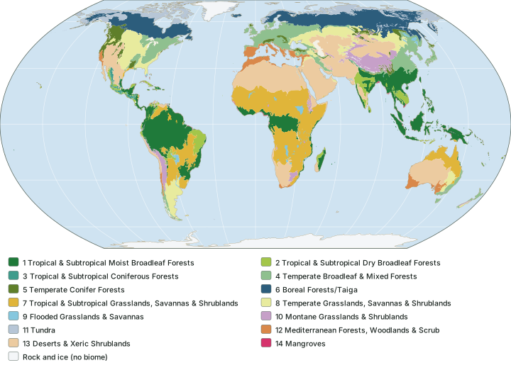
The map below shows the 14 terrestrial biomes from the RESOLVE Ecoregions 2017 data. Read it by latitude. The tropical moist forests hug the equator in the Amazon, the Congo basin and South-East Asia. Deserts and xeric shrublands spread across the subtropics, from the Sahara through Arabia to the Thar, and down the west coast of South America. The boreal forest is a broad belt across North America and Eurasia, with tundra on its polar side. The Mediterranean biome is the clearest case of climate drawing a map: it appears around the Mediterranean Sea and again, far away, in California, central Chile, the Cape region of South Africa and south-western Australia, the same position on the western side of each continent.
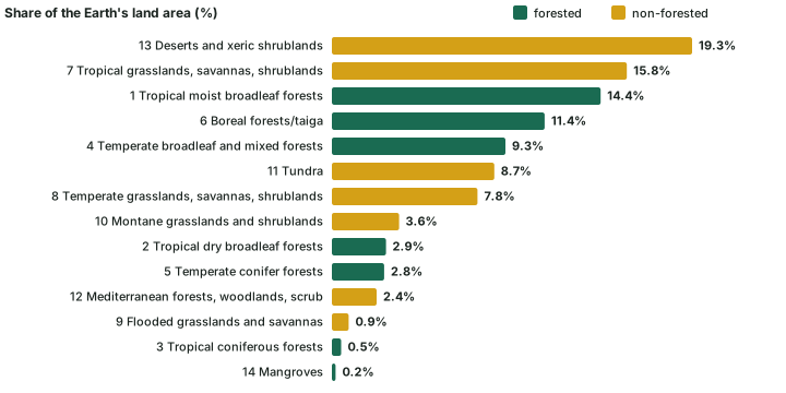
How much land does each biome cover? Dinerstein et al. (2017) give the share of the Earth's land area for every biome (the chart and table below). Deserts and xeric shrublands are the largest at 19.3%, followed by tropical and subtropical grasslands, savannas and shrublands (15.8%) and tropical and subtropical moist broadleaf forests (14.4%). Mangroves are the smallest at 0.2%. The forested biomes, among which the paper counts mangroves, add up to 41.5% of the land and the non-forested biomes to 58.5%. The same table gives the average share of each biome that is protected: flooded grasslands and savannas have the highest (32%) and temperate grasslands the lowest (4%).
Remember
Dinerstein et al. (2017) also sorted the 846 ecoregions into four protection classes. Only 98 reached the top class, "Half Protected", while 207 fell in the lowest, "Nature Imperiled" (Table 1 of the paper). The paper's title states its aim, "protecting half the terrestrial realm"; the biodiversity hotspots part covers the separate global target, agreed in 2022, to conserve at least 30% of land, inland waters, coastal and marine areas by 2030.
The 14 terrestrial biomes: share of land, protection and number of ecoregions (2017)
| No. | Biome (WWF/RESOLVE name) | Group | % of Earth's land | Mean % protected | Ecoregions |
|---|---|---|---|---|---|
| 1 | Tropical and Subtropical Moist Broadleaf Forests | forested | 14.4 | 12 | 230 |
| 2 | Tropical and Subtropical Dry Broadleaf Forests | forested | 2.9 | 8 | 56 |
| 3 | Tropical and Subtropical Coniferous Forests | forested | 0.5 | 12 | 15 |
| 4 | Temperate Broadleaf and Mixed Forests | forested | 9.3 | 10 | 83 |
| 5 | Temperate Conifer Forests | forested | 2.8 | 17 | 47 |
| 6 | Boreal Forests/Taiga | forested | 11.4 | 9 | 26 |
| 7 | Tropical and Subtropical Grasslands, Savannas and Shrublands | non-forested | 15.8 | 15 | 57 |
| 8 | Temperate Grasslands, Savannas and Shrublands | non-forested | 7.8 | 4 | 48 |
| 9 | Flooded Grasslands and Savannas | non-forested | 0.9 | 32 | 25 |
| 10 | Montane Grasslands and Shrublands | non-forested | 3.6 | 25 | 46 |
| 11 | Tundra | non-forested | 8.7 | 8 | 51 |
| 12 | Mediterranean Forests, Woodlands and Scrub | non-forested | 2.4 | 18 | 40 |
| 13 | Deserts and Xeric Shrublands | non-forested | 19.3 | 6 | 103 |
| 14 | Mangroves | forested | 0.2 | 26 | 19 |
| Forested subtotal | 41.5 | 13 | 476 | ||
| Non-forested subtotal | 58.5 | 10 | 370 | ||
| All biomes | 100 | 12 | 846 |
Source: Dinerstein et al. (2017), Table 1 ("Percentage of Earth's terrestrial area", "Mean percentage of protected within biome", total ecoregions): Dinerstein et al. (2017), "An ecoregion-based approach to protecting half the terrestrial realm", BioScience 67: 534-545. Subtotals as printed in the paper.
The major biomes one by one
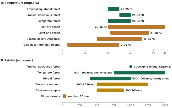
NCERT's Table 15.1 gives each biome sub-type a location, a temperature range, a rainfall figure, a soil type and typical plants and animals. Those figures are the exam baseline, and they are drawn to scale in the chart below and summarised in the table at the end of this section. Note what the figures are: broad textbook ranges for each sub-type, not limits measured at a boundary. The WWF biome that each sub-type corresponds to is named alongside, with its share of land from the table above.
Tropical rainforest (tropical equatorial forest)
NCERT places the tropical equatorial forest within about 10° north and south of the equator, with temperatures of 20-25 °C and rain evenly distributed through the year. The vegetation has a multi-layered canopy of tall, large trees, and insects, bats, birds and mammals are common. The soils, NCERT notes, are acidic and poor in nutrients; soil formation explains how heavy rain leaches tropical soils. Its WWF counterpart, tropical and subtropical moist broadleaf forests, covers 14.4% of the land and holds 230 ecoregions, the most of any biome (Dinerstein et al. 2017).
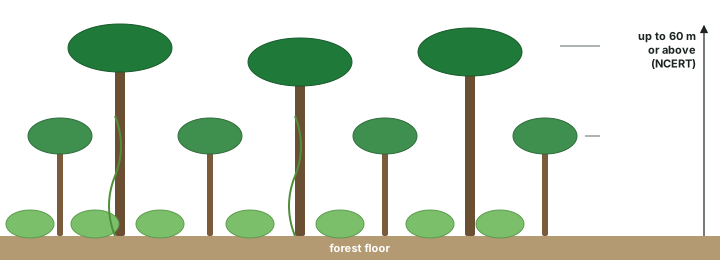
The forest is stacked in layers. NCERT's description of India's evergreen forests applies to the biome as a whole: "Tropical evergreen forests are well stratified, with layers closer to the ground and are covered with shrubs and creepers, with short structured trees followed by tall variety of trees", and the trees "reach great heights up to 60 m or above" (diagram below). There is, NCERT adds, "no definite time for trees to shed their leaves, flowering and fruition", so these forests look green all the year round.
Tropical deciduous forest
Between about 10° and 25° north and south, NCERT's tropical deciduous forest has temperatures of 25-30 °C and an average annual rainfall of 1,000 mm that comes in one season. The trees are of medium height and less dense, with many species growing together, and the soils are rich in nutrients. The trees shed their leaves in the dry season to save water. In India these are the monsoon forests (see India's natural vegetation below). The WWF biome of tropical and subtropical dry broadleaf forests covers 2.9% of the land.
Savanna (tropical grassland)
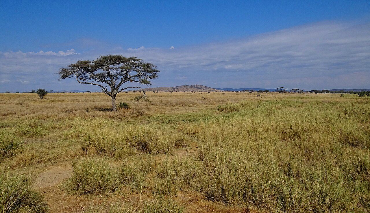
NCERT's tropical savannah covers large areas of Africa, Australia, South America and India, in warm to hot climates with 500-1,250 mm of rain. Grasses dominate; the soil is porous with a thin layer of humus; and the animals include giraffes, zebras, buffalos, leopards, hyenas and elephants, with mice, moles, snakes and worms. In the WWF scheme this is the biome of tropical and subtropical grasslands, savannas and shrublands, the second largest at 15.8% of the land.
Hot and cold deserts
All four of NCERT's desert types receive less than 50 mm of rain. The hot-dry deserts (the Sahara, Kalahari, Marusthali or Thar, and Rub-el-Khali) range from 20 to 45 °C; the semi-arid margins of the hot deserts from 21 to 38 °C; the coastal Atacama from 15 to 35 °C; and the cold deserts of the tundra regions from 2 to 25 °C. Desert soils are "rich in nutrients with little or no organic matter": the minerals are there, but the water and the plant litter are not. Vegetation is scanty, with few large mammals but many insects, reptiles and birds; the cold deserts hold rabbits, rats, antelopes and ground squirrels. WWF's deserts and xeric shrublands biome is the largest of all, at 19.3% of the land.
The photographs below put the two side by side: savanna in Tanzania, and the Sahara in Algeria seen from the International Space Station.
Mediterranean forests, woodlands and scrub
NCERT's table has no Mediterranean row, but the WWF scheme treats it as a biome of its own, covering 2.4% of the land. Its pattern on the map (see the world map above) is the lesson: the same biome recurs on five widely separated coasts, around the Mediterranean Sea and in California, central Chile, the Cape region and south-western Australia, because those places share a similar climate, not a shared ancestry of species. It is the textbook proof that a biome is a climatic unit, not a realm.
Temperate grassland (steppe)
NCERT's temperate steppe lies in parts of Eurasia and North America, with hot summers, cold winters and 500-900 mm of rain. The soil is thin and flocculated, "rich in bases" (soil classification places the grassland soils in the world schemes). Grasses dominate, with occasional trees such as cottonwoods, oaks and willows, and grazing animals such as gazelles. WWF's temperate grasslands, savannas and shrublands cover 7.8% of the land, but only 4% of the biome, on average, is protected.
Temperate deciduous forest
In eastern North America, north-east Asia and western and central Europe, NCERT's temperate forest has temperatures of 20-30 °C, 750-1,500 mm of rain spread through the year, well-defined seasons and a distinct winter. Moderately dense broad-leaved trees such as oak, beech and maple shed their leaves in autumn, and the litter makes the soil "fertile, enriched with decaying litter". Animals include squirrels, rabbits, skunks, birds, black bears and mountain lions. The WWF biome is temperate broadleaf and mixed forests (9.3% of the land); temperate conifer forests (2.8%) are a separate biome.
Boreal forest (taiga)
The boreal forest is a broad belt across Eurasia and North America: NCERT names parts of Siberia, Alaska, Canada and Scandinavia. Summers are short, moist and moderately warm; winters are long, cold and dry; and the 400-1,000 mm of precipitation falls mostly as snow. Evergreen conifers such as pine, fir and spruce dominate, with woodpeckers, hawks, bears, wolves, deer, hares and bats. The soil is acidic, thin and poor in nutrients, the setting for podzolisation (soil formation). Boreal forests/taiga cover 11.4% of the land but hold only 26 ecoregions: the biome is vast and fairly uniform.
Tundra
Beyond the tree line, on the polar side of the taiga and on high mountains, lies the tundra. NCERT treats the "tundra climatic regions" as cold deserts (2-25 °C, less than 50 mm), and notes that in the Himalaya, "At higher altitudes, mosses and lichens form part of the tundra vegetation." WWF's tundra biome covers 8.7% of the land.
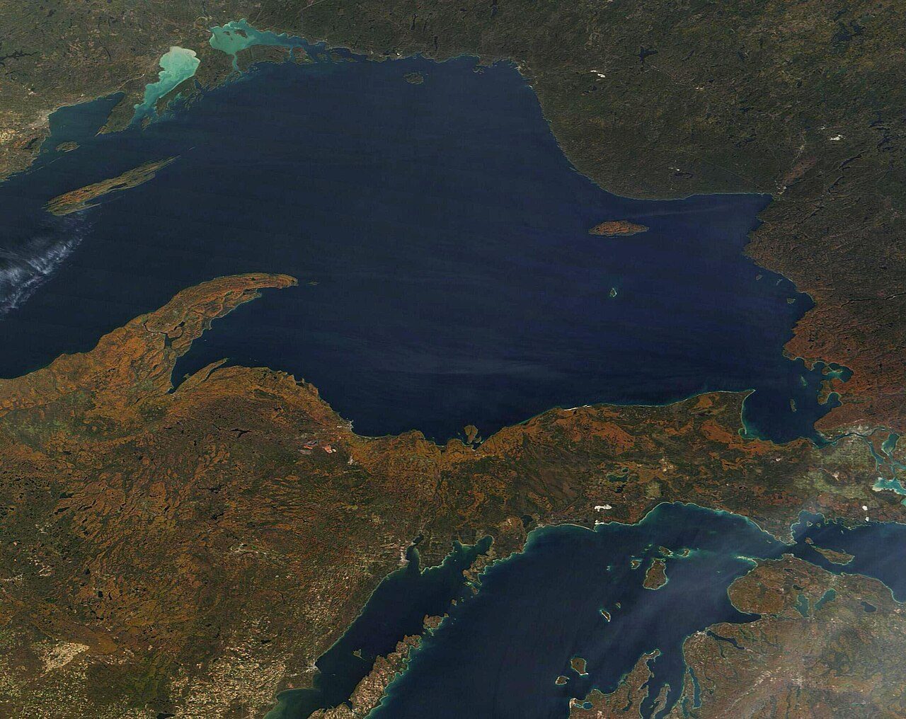
The photographs below show the temperate and cold end of the sequence: deciduous forest in autumn colour, a wooded trail in Alaska (NCERT lists Alaska among the boreal forest regions) and the Arctic tundra.
Mangroves, montane grasslands and the smaller biomes
Mangroves are forests of salt-tolerant trees on tropical coasts. NCERT says they "grow along the coasts in the salt marshes, tidal creeks, mud flats and estuaries" and "consist of a number of salt-tolerant species of plants". They are the smallest biome (0.2% of the land) but among the best protected, with 26% of the biome protected on average. Montane grasslands and shrublands (3.6%) include the Tibetan Plateau (a computed point check on the map). The other small biomes are flooded grasslands and savannas (0.9%, such as the Pantanal of South America) and tropical and subtropical coniferous forests (0.5%).
NCERT's biome sub-types: where, climate, soil and life
| Biome and sub-type | Where | Climate | Soil | Vegetation and animals |
|---|---|---|---|---|
| Forest: tropical equatorial | 10° N-S | 20-25 °C; rain evenly distributed | Acidic, poor in nutrients | Multi-layered canopy of tall, large trees; insects, bats, birds, mammals |
| Forest: tropical deciduous | 10°-25° N and S | 25-30 °C; 1,000 mm average, seasonal | Rich in nutrients | Less dense, medium-height trees of many species |
| Forest: temperate | E North America, NE Asia, W and C Europe | 20-30 °C; 750-1,500 mm; distinct winter | Fertile, enriched with decaying litter | Oak, beech, maple; squirrels, rabbits, skunks, black bears, mountain lions |
| Forest: boreal | Siberia, Alaska, Canada, Scandinavia | Long cold dry winter; 400-1,000 mm, mostly snow | Acidic, poor in nutrients, thin | Pine, fir, spruce; woodpeckers, hawks, bears, wolves, deer, hares, bats |
| Desert: hot-dry | Sahara, Kalahari, Marusthali, Rub-el-Khali | 20-45 °C; less than 50 mm | Rich in nutrients, little or no organic matter | Scanty vegetation; few large mammals, insects, reptiles, birds |
| Desert: semi-arid | Margins of hot deserts | 21-38 °C; less than 50 mm | As above | As above |
| Desert: coastal | Atacama | 15-35 °C; less than 50 mm | As above | As above |
| Desert: cold | Tundra climatic regions | 2-25 °C; less than 50 mm | As above | Rabbits, rats, antelopes, ground squirrels |
| Grassland: tropical savannah | Africa, Australia, South America, India | Warm to hot; 500-1,250 mm | Porous, thin layer of humus | Grasses; giraffes, zebras, buffalos, leopards, hyenas, elephants |
| Grassland: temperate steppe | Parts of Eurasia and North America | Hot summers, cold winters; 500-900 mm | Thin, flocculated, rich in bases | Grasses, occasional cottonwoods, oaks, willows; gazelles |
Source: NCERT, Fundamentals of Physical Geography, Class XI, chapter 15 "Life on the Earth" (2020 reprint; the chapter was dropped from the 2026-27 reprint), Table 15.1 (wording condensed).
Aquatic biomes
Most of the biosphere by area is water. NCERT divides aquatic ecosystems into two: marine ecosystems, which include "the oceans, estuaries and coral reefs", and freshwater ecosystems, which include "lakes, ponds, streams, marshes and bogs". Where the WWF terrestrial scheme stops at the coast, NCERT counts the aquatic biome as one of its five major biomes. Freshwater is not one of the 14 WWF terrestrial biomes. Estuaries, which NCERT lists under marine ecosystems, and mangroves, which WWF counts as a land biome, sit where the two meet.
Exam tip
Know both answers to "how many biomes?": NCERT: five major biomes (forest, desert, grassland, aquatic, altitudinal); WWF/RESOLVE: 14 terrestrial biomes (no aquatic biome, but mangroves and flooded grasslands are on the list). A question that names the WWF scheme expects 14.
Altitudinal zonation: biomes stacked on a mountain
Climbing a mountain is like travelling towards the poles: the air cools with height, so the vegetation changes in belts. NCERT treats this as the altitudinal biome, found on high ranges such as the Himalaya, the Andes and the Rockies. In India's montane forests, it says, "the decrease in temperature with increasing altitude leads to a corresponding change in natural vegetation", and "The Himalayan ranges show a succession of vegetation from the tropical to the tundra".
NCERT's Himalayan sequence (diagram below) runs as follows. Deciduous forests grow in the foothills. Wet temperate forests follow between 1,000 and 2,000 m, with evergreen broad-leaved trees such as oak and chestnut in the hills of north-eastern India, West Bengal and Uttaranchal, as NCERT names them. Pine forests are well developed between 1,500 and 1,750 m, chir pine being the main commercial tree; deodar grows mainly in the western Himalaya, and the chinar and walnut that sustain Kashmir's handicrafts belong to this zone. Blue pine and spruce appear at 2,225-3,048 m, with temperate grasslands in places. Higher still, alpine forests and pastures take over: silver firs, junipers, pines, birch and rhododendrons occur between 3,000 and 4,000 m. The pastures are used for transhumance by the Gujjars, the Bakarwals, the Bhotiyas and the Gaddis. At the top, mosses and lichens form the tundra vegetation.
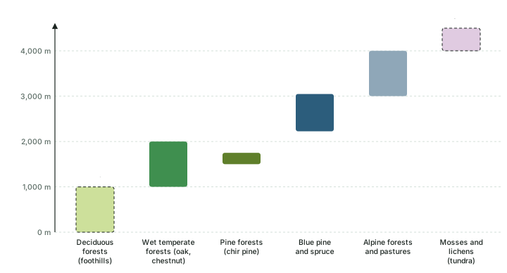
Aspect matters as much as height. "The southern slopes of the Himalayas carry a thicker vegetation cover because of relatively higher precipitation than the drier north-facing slopes," NCERT notes. In the peninsula, the southern mountain forests of the Western Ghats, the Vindhyas and the Nilgiris are "closer to the tropics, and only 1,500 m above the sea level", so the vegetation is temperate in the higher regions and subtropical lower down, "especially in Kerala, Tamil Nadu and Karnataka". The temperate forests here are called sholas in the Nilgiris, Anaimalai and Palani hills, with magnolia, laurel, cinchona and wattle among their trees.
India's natural vegetation as NCERT gives it
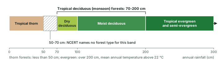
NCERT divides India's forests into five groups by vegetation and climate: tropical evergreen and semi-evergreen forests; tropical deciduous forests; tropical thorn forests; montane forests; and littoral and swamp forests. Rainfall is the main divider among the tropical types (the diagram and table below).
India's forest types (NCERT)
| Type | Rainfall | Where | Main species |
|---|---|---|---|
| Tropical evergreen and semi-evergreen | Over 200 cm; mean annual temperature above 22 °C | Western slope of the Western Ghats; hills of the north-east; Andaman and Nicobar Islands | Rosewood, mahogany, aini, ebony; semi-evergreen: white cedar, hollock, kail |
| Moist deciduous | 100-200 cm | North-eastern states along the Himalayan foothills; eastern slopes of the Western Ghats; Odisha | Teak, sal, shisham, hurra, mahua, amla, semul, kusum, sandalwood |
| Dry deciduous | 70-100 cm | Rainier parts of the Peninsula; plains of Uttar Pradesh and Bihar | Tendu, palas, amaltas, bel, khair, axlewood |
| Tropical thorn | Less than 50 cm | Semi-arid south-west Punjab, Haryana, Rajasthan, Gujarat, Madhya Pradesh and Uttar Pradesh | Babool, ber, wild date palm, khair, neem, khejri, palas |
| Montane | Set by altitude | Himalaya; Western Ghats, Vindhyas, Nilgiris (sholas in the Nilgiris, Anaimalai, Palani hills) | Oak, chestnut, chir pine, deodar, blue pine, spruce, silver fir; magnolia, laurel |
| Littoral and swamp (mangroves) | Tidal coasts | Andaman and Nicobar Islands; Sunderbans of West Bengal; Mahanadi, Godavari and Krishna deltas | Salt-tolerant species |
Source: NCERT, India: Physical Environment, Class XI, chapter 5 "Natural Vegetation" (Reprint 2026-27).
The tropical deciduous or monsoon forests "are the most widespread forests in India", spreading over regions with 70-200 cm of rain. In the drier, dry-deciduous parts the trees "shed their leaves completely" as the dry season begins, and the forest "appears like a vast grassland with naked trees all around". The thorn forests "remain leafless for most part of the year", and tussocky grass grows up to 2 m as the undergrowth. History has also reshaped the map: NCERT records that the oak forests of Garhwal and Kumaon were replaced by chir pine, which was needed to lay railway lines, and that forests were cleared for tea, rubber and coffee plantations.
Don't confuse
Evergreen vs semi-evergreen vs moist deciduous. Evergreen forests (over 200 cm) have no fixed season of leaf fall. Semi-evergreen forests grow in "the less rainy parts" of the same regions and mix evergreen with moist deciduous trees. Moist deciduous forests (100-200 cm) shed their leaves in the dry season. Teak and sal are deciduous species, not evergreen ones.
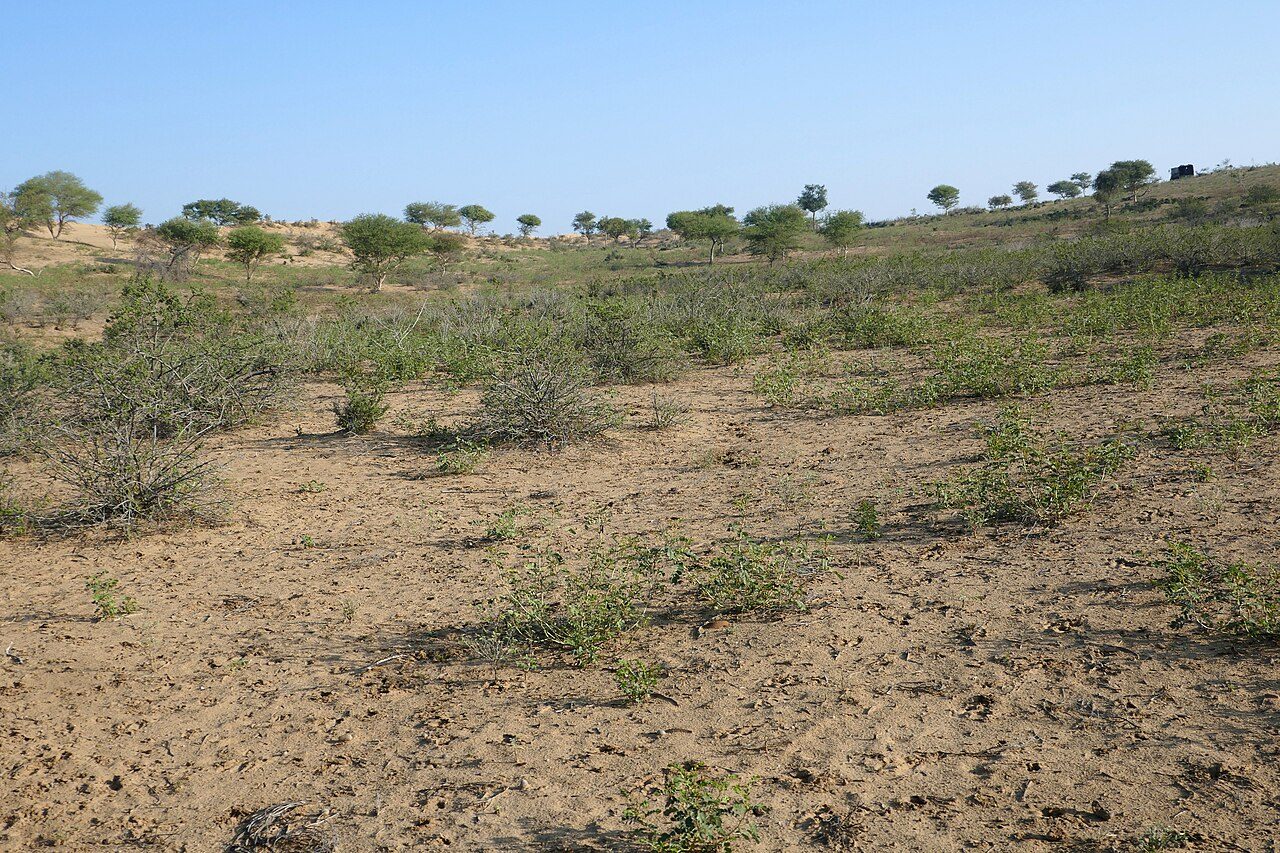
The photographs below show two rows of the forest-types table on the ground: vegetation in the Thar Desert of Rajasthan, a state NCERT lists under tropical thorn forest, and mangrove forest in the Sundarbans of West Bengal.
Biomes on the move
If climate draws the biome map, a changing climate must redraw it, and the redrawing has begun. The Intergovernmental Panel on Climate Change (IPCC), in its 2022 assessment of impacts, found that "Approximately half of the species assessed globally have shifted polewards or, on land, also to higher elevations (very high confidence)." It added that "Some losses are already irreversible, such as the first species extinctions driven by climate change (medium confidence)." The two directions of movement are the two climate gradients described above (under climate as the master control) run in reverse: towards the poles and up the mountains (see the Himalayan zones diagram above).
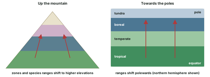
The global assessment by IPBES (the Intergovernmental Science-Policy Platform on Biodiversity and Ecosystem Services), released in May 2019, reached a matching conclusion: "Even for global warming of 1.5 to 2 degrees, the majority of terrestrial species ranges are projected to shrink profoundly." On a mountain the geometry is unforgiving: a belt that moves upslope has less room at each step, and the highest belt eventually runs out of mountain (diagram above). The biodiversity hotspots part returns to climate change as one of the five direct drivers of biodiversity loss.
Key idea
The logic of this part in one line. Climate sets the biome; the biome shapes the soil and the life it carries; so when climate changes, biomes and species move polewards and upslope, and those that cannot move are at risk.
Summary
- The biosphere is all the living components of the Earth. Organism, population, community, ecosystem and biome are its nested levels; a habitat is where a species lives, a niche is its role.
- A biome is "a plant and animal community that covers a large geographical area", with boundaries set mainly by climate (NCERT). Temperature and moisture together sort the biomes.
- NCERT names five major biomes (forest, desert, grassland, aquatic, altitudinal); the WWF/RESOLVE scheme has 14 terrestrial biomes and 846 ecoregions (2017).
- Deserts and xeric shrublands are the largest biome (19.3% of land) and mangroves the smallest (0.2%) (Dinerstein et al. 2017).
- Mountains stack biomes by altitude; NCERT's Himalayan sequence runs from foothill deciduous forest through wet temperate, pine, blue pine and spruce, and alpine zones to tundra.
- India's tropical forest types follow rainfall: evergreen over 200 cm, moist deciduous 100-200 cm, dry deciduous 70-100 cm, thorn under 50 cm (NCERT).
- About half of the species assessed have already shifted polewards or upslope (IPCC, 2022).
Biome, ecoregion and realm compared
| Biome | Ecoregion | Realm | |
|---|---|---|---|
| Groups places by | The kind of vegetation the climate allows | A smaller regional unit; the 2017 data give each one biome and one realm | Shared evolutionary history of the animals and plants |
| Set mainly by | Climate (temperature and moisture) | Regional differences within a biome | Past land connections and barriers (biogeographic realms) |
| Count (WWF/RESOLVE) | 14 terrestrial biomes | 867 (2001); 846 (2017) | 8 realms (Olson et al. 2001; the 2017 data file keeps the same 8, though the 2017 paper's text speaks of "seven") |
| Example | Tropical moist broadleaf forest (Amazon, Congo, Western Ghats) | One forest type in one region, such as the forests of one mountain range | Indomalayan realm (India, South-East Asia) |
| Repeats on other continents? | Yes: the Mediterranean biome occurs on five coasts | No | No: each realm covers its own part of the world |
Sources for the counts: Olson et al. 2001; Dinerstein et al. 2017; realm names in the RESOLVE Ecoregions 2017 data set. Definitions: NCERT, Fundamentals of Physical Geography, Class XI, chapter 15 (2020 reprint); this part.
Sources
Each table and data figure names its source beneath it. The main documents are collected here, with a date where the source carries one. Figures not listed under image credits were drawn for this page from the sources stated in their source lines.
Main sources
| Topic | Source |
|---|---|
| Chapter 15 definitions (biosphere, ecosystem, habitat, biome); biome sub-types (Table 15.1); aquatic ecosystems | NCERT, Fundamentals of Physical Geography, Class XI, chapter 15 "Life on the Earth" (2020 reprint; the chapter was dropped from the 2026-27 reprint) |
| India's forest types, Himalayan vegetation zones, mangroves | NCERT, India: Physical Environment, Class XI, chapter 5 "Natural Vegetation" (Reprint 2026-27) |
| First printed use of "Oecologie" | Haeckel, Generelle Morphologie der Organismen, vol. 2 (1866), p. 286 |
| The 14 biomes: share of land, protection, ecoregions (2017) | Dinerstein et al. (2017), "An ecoregion-based approach to protecting half the terrestrial realm", BioScience 67: 534-545 |
| World biome map data | RESOLVE Ecoregions 2017 catalogue entry (data licence CC BY 4.0); coastlines: Natural Earth |
| Earlier biome schemes; 867 ecoregions and 8 realms (2001) | Olson et al. (2001); Udvardy (1975), A Classification of the Biogeographical Provinces of the World, IUCN Occasional Paper 18 |
| Species shifting polewards and upslope | IPCC (2022), Climate Change 2022: Impacts, Adaptation and Vulnerability, Working Group II, Summary for Policymakers, paragraph B.1.2 |
| Species ranges under 1.5 to 2 degrees of warming | IPBES, Global Assessment media release (6 May 2019) |
Image credits
| Image | Credit and licence |
|---|---|
| Serengeti National Park, western Tanzania: grass plains with acacias | Bjørn Christian Tørrissen. CC BY-SA 3.0. File page |
| Part of the Sahara Desert in Algeria, from the International Space Station | NASA. Public domain. File page |
| Autumn colour in the forests south of Lake Superior, MODIS on NASA's Terra satellite | MODIS Land Rapid Response Team, NASA GSFC. Public domain. File page |
| Seven Lakes trail, Kenai National Wildlife Refuge, Alaska | Beeblebrox. CC BY-SA 3.0. File page |
| Adult dunlin on the Arctic tundra | Lisa Hupp/USFWS. Public domain. File page |
| Vegetation in the Thar Desert, Rajasthan | Ji-Elle. CC BY-SA 4.0. File page |
| Mangrove forest in Sundarbans National Park, West Bengal | Kingshuk Mondal. CC BY 4.0. File page |
| All other figures | Drawn for this page from the sources given in their source lines. |




