 BharatNotes
Part 3 of 9 of the Soils and Biogeography notes. The overview page has the quick revision and exam strategy for all nine parts.
Classifying the World's Soils
Soils vary from place to place, and every scientist who maps them needs names that others will understand. This part follows how those names were made: the old zonal scheme, built on how a soil was thought to have formed; USDA Soil Taxonomy, built on measured properties; and the international World Reference Base. It ends by showing why the black soils of India do not map onto a single USDA order.
Why soils are classified
A soil map is only useful if its names mean the same thing to every reader. NCERT puts it simply: "Classification of the soil is an effort to achieve this objective", the objective being a scientific study of the soil. It adds that in India, "to make it comparable at the international level", the ICAR classified Indian soils "as per the United States Department of Agriculture (USDA) Soil Taxonomy" (NCERT, India: Physical Environment, Class XI, 2020 edition, ch 6 (dropped from the current book)).
There are two ways to build a classification. A genetic scheme groups soils by how they are thought to have formed: by climate, vegetation or a local factor. A morphometric scheme groups them by properties that can be seen and measured in the profile, such as a diagnostic horizon, clay content or base saturation. The history of soil classification is largely a move from the first to the second.
Zonal, intrazonal and azonal soils
Zonal, intrazonal and azonal soils are an older grouping from the Russian school, adopted in the USDA's 1938 Yearbook of Agriculture, now superseded by Soil Taxonomy and WRB. The USDA's Seventh Approximation (Soil Survey Staff, 1960) credits N. M. Sibirtsev with introducing the concepts of zonal, intrazonal and azonal soils. In its words, Sibirtsev "introduced the concepts of zonal, intrazonal, and azonal soils in place of Dokuchaiev's divisions of normal, transitional, and abnormal" (USDA Soil Survey Staff, Soil Classification: A Comprehensive System, 7th Approximation (Soil Conservation Service, 1960), p. 7). The same page tabulates Dokuchaev's final classification (spelt Dokuchaiev in the source), which it dates to 1900, with those three classes: normal or zonal soils, transitional soils and abnormal soils (see climate and soil, below).
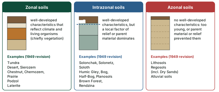
In the United States the scheme was published by Baldwin, Kellogg and Thorp in "Soil Classification", in Soils and Men, the USDA Yearbook of Agriculture for 1938, and revised in 1949 by Thorp and Smith. The Seventh Approximation quotes the 1938 definitions of the three orders (see the diagram below):
- Zonal soils are "those great groups having well-developed soil characteristics that reflect the influence of the active factors of soil genesis", namely "climate and living organisms (chiefly vegetation)".
- Intrazonal soils "have more or less well-developed soil characteristics that reflect the dominating influence of some local factor of relief or parent material over the normal effect of the climate and vegetation."
- Azonal soils "are without well-developed soil characteristics either because of their youth or because conditions of parent material or relief have prevented the development of definite soil characteristics."
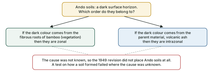
The weakness lay in how the orders were defined. The Seventh Approximation notes: "The azonal order was defined in terms of soil characteristics. The zonal and intrazonal orders, however, were defined primarily in genetic terms." A new soil could only be placed once its cause was known. Its own example is the Ando soils of volcanic regions: a dark surface from bamboo roots would make them zonal, a dark surface from volcanic ash would make them intrazonal, and since nobody knew which, "the Ando soils were not placed in the 1949 revision of the system" (USDA Soil Survey Staff, Soil Classification: A Comprehensive System, 7th Approximation (Soil Conservation Service, 1960), p. 10). The diagram below shows the dilemma.
Why it happens: How did this soil form?
The zonal scheme asked how did this soil form? Soil Taxonomy asks what does this soil have? The second question can be answered in the field and the laboratory, so two surveyors working apart will reach the same name.
The 1949 revision of the USDA scheme, in outline
| Order | Suborder (as worded in the source) | Great soil groups |
|---|---|---|
| Zonal | Soils of the cold zone | Tundra |
| Light-colored soils of arid regions | Desert, Red Desert, Sierozem, Brown, Reddish-Brown | |
| Dark-colored soils of semi-arid, subhumid and humid grasslands | Chestnut, Reddish Chestnut, Chernozem, Prairie, Reddish Prairie | |
| Soils of the forest-grassland transition | Degraded Chernozem, Noncalcic Brown or Shantung Brown | |
| Light-colored podzolized soils of the timbered regions | Podzol, Gray wooded or Gray Podzolic, Brown Podzolic, Gray-Brown Podzolic, Red-Yellow Podzolic | |
| Lateritic soils of forested warm-temperate and tropical regions | Reddish-Brown Lateritic, Yellowish-Brown Lateritic, Laterite | |
| Intrazonal | Halomorphic (saline and alkali) soils of imperfectly drained arid regions and littoral deposits | Solonchak or Saline, Solonetz, Soloth |
| Hydromorphic soils of marshes, swamps, seep areas and flats | Humic Gley (incl. Wiesenboden), Alpine Meadow, Bog, Half-Bog, Low-Humic Gley, Planosols, Ground-Water Podzol, Ground-Water Laterite | |
| Calcimorphic soils | Brown Forest (Braunerde), Rendzina | |
| Azonal | (no suborders) | Lithosols, Regosols (incl. Dry Sands), Alluvial soils |
Source: USDA Soil Survey Staff, Soil Classification: A Comprehensive System, 7th Approximation (Soil Conservation Service, 1960), table 4 (p. 9), "the outline of the last revision". American spellings kept as printed.
Soil Taxonomy: six categories
The USDA Soil Survey Staff replaced the old scheme with Soil Taxonomy, built through a series of approximations of which the seventh was published in 1960. Its first edition appeared in 1975 with 10 orders; the second, in 1999, has 12. The system is a ladder: "There are six categories in soil taxonomy. In order of decreasing rank and increasing number of differentiae and classes, the categories are order, suborder, great group, subgroup, family, and series." (USDA Soil Survey Staff, Soil Taxonomy, 2nd ed. (1999), ch. 6). The same book counts "64 suborders" and "more than 300 great groups", both 1999 figures (see the diagram below).
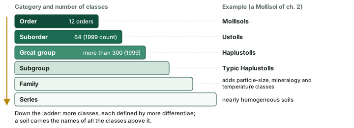
Each step down adds properties. A suborder has "the properties common to the order plus the properties used for sorting into that suborder", and the sorting "continues in the remaining categories down to the soil series", whose soils are "nearly homogeneous in that their range of properties is small" (USDA Soil Survey Staff, Soil Taxonomy, 2nd ed. (1999), ch. 6).
The 12 orders and the Key to Soil Orders
Soil Taxonomy does not let the user choose an order. It gives a key, a list of tests read from the top, and "The soil belongs to the first class listed for which it meets all the required criteria." (USDA Soil Survey Staff, Keys to Soil Taxonomy, 13th ed. (2022), ch. 4). Every line after the first begins "Other soils", so a soil reaches line H only after failing A to G. The last line, L, has no test at all: it reads "Other soils." and names the Entisols (see the diagram below).
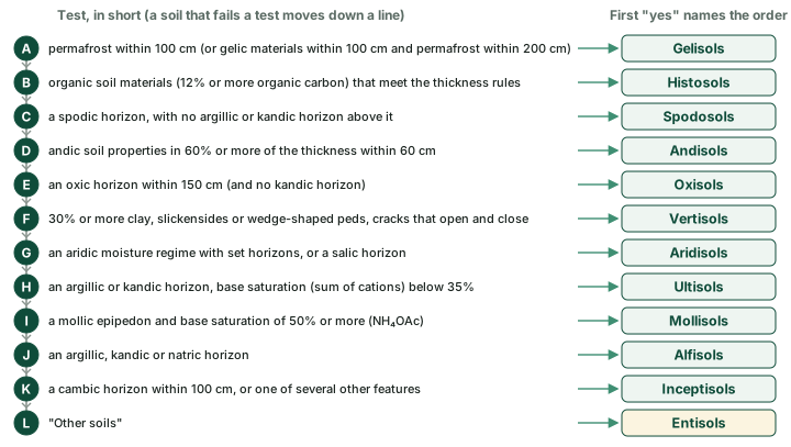
The example in the caption above is real. The Keys record that "When the Gelisols order was adopted in 1998 there was debate about whether these organic soils with permafrost should be in the Gelisols order (Histels) or remain as Histosols" (USDA Soil Survey Staff, Keys to Soil Taxonomy, 13th ed. (2022), ch. 9). Two orders are newer than the rest: Andisols were accepted as the 11th order in 1989 (USDA Soil Survey Staff, Soil Taxonomy, 2nd ed. (1999)) and Gelisols in 1998, giving the 12 of the 1999 edition.
Three tests trip readers. The Andisol test is about andic soil properties, not ash as such: the Keys note that soils "in cool, humid climates" with abundant organic carbon "may develop andic soil properties without the influence of volcanic glass". The Vertisol test asks for clay, slickensides and cracks; smectite clay is typical but is not part of the test. Ultisols and Alfisols both have an argillic or kandic horizon (Alfisols may instead have a natric horizon); the Ultisol line takes those with a base saturation (by sum of cations) below 35% at a set depth, and soils with such a horizon that fail both the Ultisol and the Mollisol tests key out as Alfisols at line J (USDA Soil Survey Staff, Keys to Soil Taxonomy, 13th ed. (2022), ch. 3-4).
The setting a soil is usually found in helps memory but never decides the order. The soil profile part drew typical profiles: Spodosols under cool, humid forest, Mollisols under semi-arid grassland, Aridisols in desert, Gelisols on tundra and Oxisols in the humid tropics. These are typical, not defining. In India, NCERT's table puts Inceptisols (39.74%) and Entisols (28.08%) first; the soils of India part gives India's shares in full.
The 12 orders of Soil Taxonomy
| Key | Order | Formative element: derivation | Key test, in short |
|---|---|---|---|
| A | Gelisols | el: L. gelare, to freeze | permafrost within 100 cm; or gelic materials within 100 cm and permafrost within 200 cm |
| B | Histosols | ist: Gr. histos, tissue | organic soil materials (12% or more organic carbon, about 20% organic matter) meeting thickness rules |
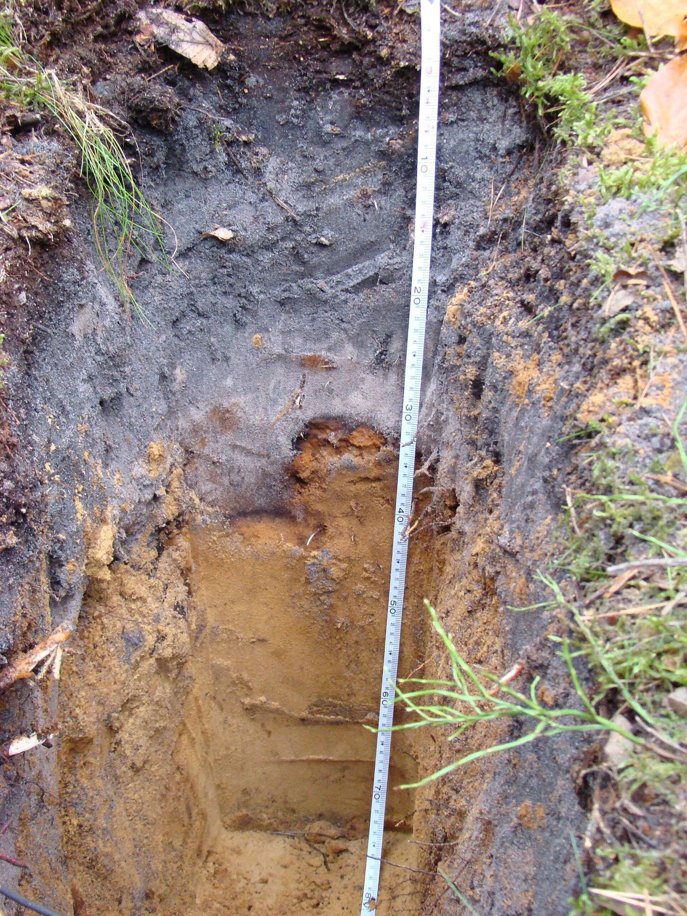
| C | Spodosols | od: Gr. spodos, wood ash | spodic horizon (illuvial organic matter and aluminium, with or without iron) |
| D | Andisols | and: Japanese, volcanic ash | andic soil properties in 60% or more of the thickness within 60 cm |
| E | Oxisols | ox: F. oxide, oxide | oxic horizon within 150 cm, no kandic horizon |
| F | Vertisols | ert: L. verto, turn | 30% or more clay; slickensides or wedge-shaped peds; cracks that open and close |
| G | Aridisols | id: L. aridus, dry | aridic moisture regime with an ochric or anthropic epipedon and set horizons; or a salic horizon |
| H | Ultisols | ult: L. ultimus, last | argillic or kandic horizon; base saturation (sum of cations) below 35% |
| I | Mollisols | oll: L. mollis, soft | mollic epipedon; base saturation 50% or more (NH4OAc) |
| J | Alfisols | alf: Al and Fe, via Marbut's "Pedalfers" | argillic, kandic or natric horizon |
| K | Inceptisols | ept: L. inceptum, beginning | cambic horizon within 100 cm, or other listed features |
| L | Entisols | ent: Recent | "Other soils" |
Source: USDA Soil Survey Staff, Keys to Soil Taxonomy, 13th ed. (2022), ch. 1 (Table 1-1, formative elements) and ch. 4 (Key to Soil Orders); spodic materials from ch. 3.
Key idea: The key is read in order
The key is read in order, A to L. A soil is named by the first test it passes, even if it would also pass a later one. Entisols are simply the soils left over.
The podzol in the photo below shows the Spodosol test in a real pit: a pale grey layer near the top, from which iron and aluminium have moved down with organic matter, over a rust-brown band where they have accumulated.
A short history
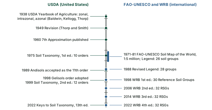
Two lines of work ran side by side (see the diagram below). In the United States, the 1938 scheme and its 1949 revision gave way to the Seventh Approximation of 1960 and then to Soil Taxonomy: 1975 (10 orders), 1989 (Andisols accepted as an order) and 1999 (12 orders). The Keys to Soil Taxonomy, which carry the current tests, reached their 13th edition in 2022. Internationally, the FAO-UNESCO Soil Map of the World (1971-1981, at 1:5 million) used a Legend of 26 soil groups, revised in 1988 to 28. WRB's own history page says WRB "has two roots": this Legend and the International Reference Base for Soil Classification (IRB). The first edition of WRB was published in 1998 (ISRIC, History of the WRB).
Reading a Soil Taxonomy name
Soil Taxonomy names are built from formative elements and are read from right to left. "The names of suborders have exactly two syllables" (USDA Soil Survey Staff, Soil Taxonomy, 2nd ed. (1999)): the first says something about the diagnostic properties, the second comes from the order. So Aquents are Entisols with aquic conditions (L. aqua, water) and Fluvents are Entisols of very young sediments (L. fluvius, river). A great group adds a prefix to the suborder, and a subgroup adds an adjective (see the diagram below).
Don't confuse: Typic and "most typical"
Typic does not mean "most common" or "most typical". Soil Taxonomy says Typic subgroups "are not necessarily the most extensive subgroups, nor do they necessarily represent the central concept of the great group". Since the 4th edition of the Keys (1990), Typic is simply the last, "all other" subgroup.
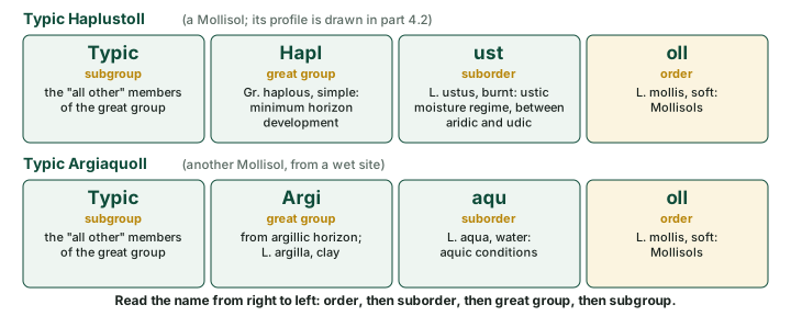
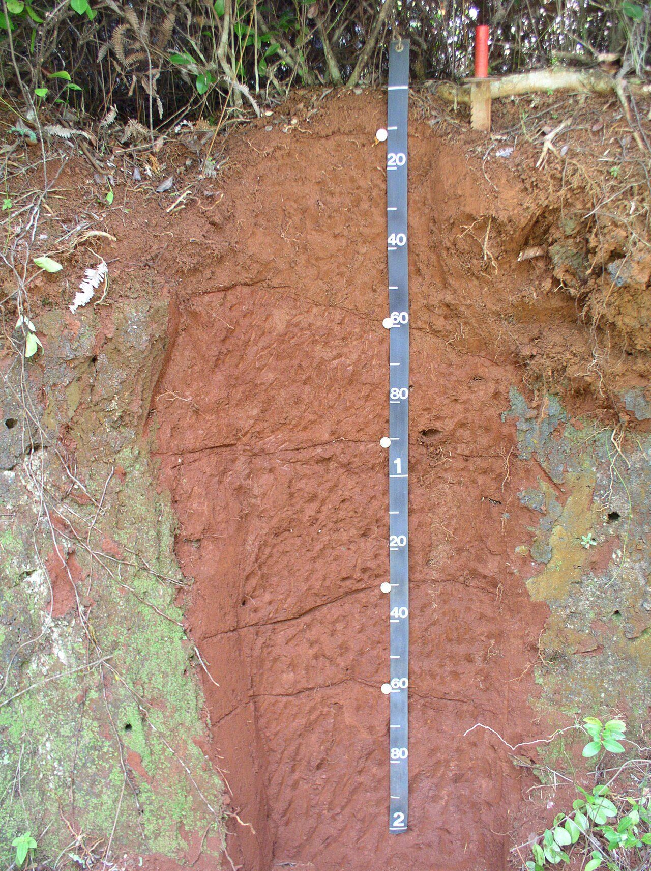
The same reading works on names attached to real profiles (see the photos below). Typic Acrudox ends in ox, the formative element of the Oxisols (F. oxide, oxide); ud (L. udus, humid) gives the suborder, Acr is the great-group prefix, and Typic marks the "all other" subgroup. Typic Hapludoll reads the same way, with oll (L. mollis, soft) for the Mollisols, ud for the suborder Udolls and Hapl (Gr. haplous, simple) for the great group. The words in brackets after it are the family, the fifth category: fine is a particle-size class, mixed a mineralogy class, active a cation-exchange activity class and isohyperthermic a soil temperature class. That Mollisol formed under tropical rain forest, not grassland: the setting is typical, not defining (see the 12 orders, above; USDA Soil Survey Staff, Keys to Soil Taxonomy, 13th ed. (2022)).
The international system: WRB
The World Reference Base for Soil Resources (WRB) is published by the IUSS Working Group WRB, not by the USDA. Its fourth edition (2022; corrections of errata, 24 September 2024) is subtitled "International soil classification system for naming soils and creating legends for soil maps". The first edition (1998) had 30 Reference Soil Groups (RSGs); the editions of 2006, 2014 and 2022 have 32 (ISRIC, History of the WRB).
WRB has two levels. The first is the 32 RSGs; the second, "consisting of the name of the RSG combined with a set of principal and supplementary qualifiers". The groups are defined by diagnostic horizons, properties and materials, and like Soil Taxonomy WRB is keyed: "The soil belongs to the first RSG for which it fulfils the criteria." (IUSS Working Group WRB, World Reference Base for Soil Resources, 4th ed. (2022, errata 2024), ch. 1-2). The diagram below lists the groups in key order.
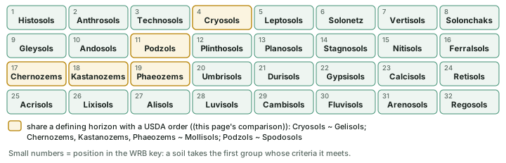
Don't confuse: WRB names and USDA names
WRB names and USDA names are not one-to-one, and WRB 2022 prints no official table pairing them. Comparing the horizon each class is defined by gives rough pairs: Cryosols have a cryic (perennially frozen) horizon starting within 100 cm, as Gelisols have permafrost within 100 cm; Podzols and Spodosols both turn on a spodic horizon; Chernozems, Kastanozems and Phaeozems all carry a mollic horizon, the surface layer that also defines Mollisols. The other criteria differ, so a soil can fall in one class and not in its "pair" (IUSS Working Group WRB, World Reference Base for Soil Resources, 4th ed. (2022, errata 2024); USDA Soil Survey Staff, Keys to Soil Taxonomy, 13th ed. (2022), ch. 4). Note the spellings: WRB Andosols and Podzols, USDA Andisols and Spodosols.
Climate and soil
The idea that climate and vegetation leave a mark on soil is older than any of these systems. Dokuchaev's final scheme of 1900, as tabulated in the Seventh Approximation, put its normal, or zonal, soils in seven zones from the boreal tundra to the tropical forests (see the diagram below). The 1949 USDA revision kept the same thinking in its zonal suborders, from "soils of the cold zone" to "lateritic soils of forested warm-temperate and tropical regions" (see the table of the 1949 revision, above).
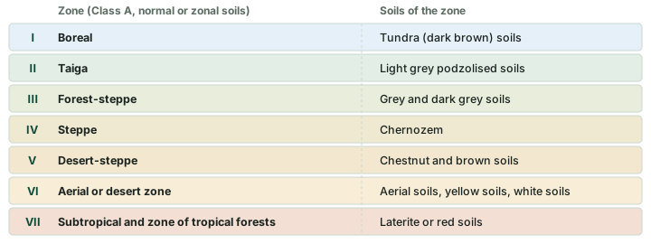
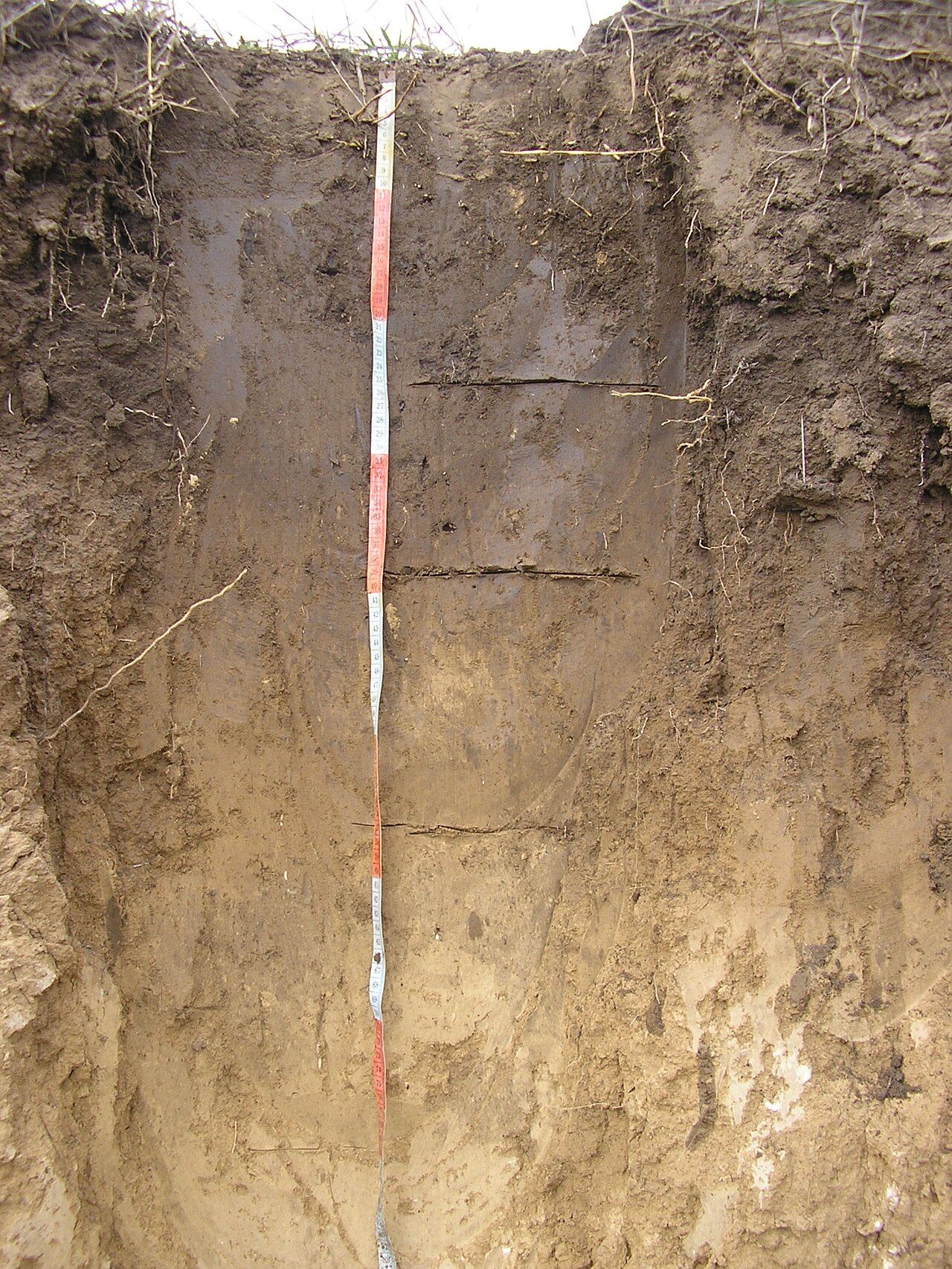
Zone IV, the steppe, is Dokuchaev's Chernozem zone. The photo below shows a Chernozem from the steppe zone of Ukraine; its Commons description also names it among the Mollisols, in line with the rough Chernozem-Mollisol correspondence described under WRB, above.
Soil Taxonomy keeps climate only where it can be measured in the soil itself. The Gelisol test uses permafrost, and the Aridisol test uses the aridic soil moisture regime; the other orders are defined by horizons and chemistry. So a climate-to-soil pairing is typical, not defining: the same climate can carry soils of several orders, depending on parent material, relief and age.
Black soil, regur and Vertisol
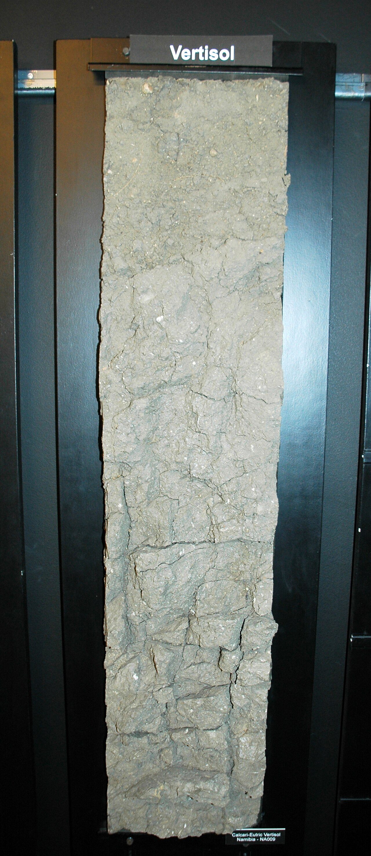
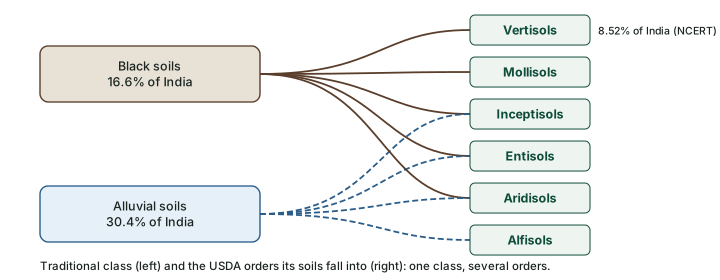
NCERT describes India's black soils as "also known as the 'Regur Soil' or the 'Black Cotton Soil'". They "swell and become sticky when wet and shrink when dried", develop wide cracks in the dry season, and so show "a kind of 'self ploughing'" (NCERT, India: Physical Environment, Class XI, 2020 edition, ch 6 (dropped from the current book)). That sounds like the Vertisol test in the table of the 12 orders above, and many black soils are Vertisols, but the two words come from different systems. Vertisol is also the name of a WRB Reference Soil Group (see the diagram of the 32 groups, above). The photo below shows a profile named on Commons as a Calcari-eutric Vertisol; no place is given, so it shows the group, not India's black soils.
Don't confuse: Black soil and Vertisol
Black soil (regur) is a traditional class named by colour and setting. Vertisol is a USDA order defined by measured clay, slickensides and cracks. NBSS&LUP scientists list the black soils under Vertisols, Mollisols, Inceptisols, Entisols and Aridisols, so the two shares differ: black soils 16.6% of India (Bhattacharyya et al., 2013), Vertisols 8.52% (NCERT). Neither figure is wrong; they measure different things.
Summary
The zonal scheme of 1938 and 1949 grouped soils by how they were thought to have formed, and it broke down when the cause was unknown. Soil Taxonomy (1975; 2nd ed. 1999) classifies by measured properties through six categories and a key of 12 orders, read from Gelisols to Entisols. WRB 2022 does the same job internationally with 32 Reference Soil Groups. The names do not match one to one, and neither do the traditional Indian classes: the soils of India part sets the two Indian tables side by side.
Three schemes compared
| Zonal scheme (USDA 1938, 1949) | Soil Taxonomy (USDA) | WRB (IUSS) | |
|---|---|---|---|
| Basis | mostly genetic: how the soil formed | measured properties: diagnostic horizons, regimes, chemistry | diagnostic horizons, properties and materials |
| Top level | 3 orders: zonal, intrazonal, azonal | 12 orders (since 1999) | 32 Reference Soil Groups (since 2006) |
| Levels | order, suborder, great soil group | six: order to series | two: RSG; RSG with qualifiers |
| Key dates | 1938 Yearbook; 1949 revision | 1960 7th Approximation; 1975; 1999; Keys 13th ed. 2022 | 1998; 2006; 2014; 2022 |
| Status | superseded | Keys 13th ed. (2022) current; used by ICAR for India | 4th ed. (2022) is the currently valid edition |
Source: USDA Soil Survey Staff, Soil Classification: A Comprehensive System, 7th Approximation (Soil Conservation Service, 1960); USDA Soil Survey Staff, Soil Taxonomy, 2nd ed. (1999); USDA Soil Survey Staff, Keys to Soil Taxonomy, 13th ed. (2022); ISRIC, History of the WRB; NCERT, India: Physical Environment, Class XI, 2020 edition, ch 6 (dropped from the current book) (ICAR use).
Sources
Each table and data figure names its source beneath it. The main documents are collected here, with a date where the source carries one. Figures not listed under image credits were drawn for this page from the sources stated in their source lines.
Main sources
| Topic | Source |
|---|---|
| Textbook | NCERT, India: Physical Environment, Class XI, 2020 edition, ch 6 (dropped from the current book) |
| Zonal, intrazonal and azonal soils; the 1938 and 1949 schemes; Dokuchaev's 1900 zones | USDA Soil Survey Staff, Soil Classification: A Comprehensive System, 7th Approximation (Soil Conservation Service, 1960) |
| Categories of Soil Taxonomy, suborder names | USDA Soil Survey Staff, Soil Taxonomy, 2nd ed. (1999) |
| Key to Soil Orders, formative elements, Typic subgroups | USDA Soil Survey Staff, Keys to Soil Taxonomy, 13th ed. (2022) |
| Reference Soil Groups | IUSS Working Group WRB, World Reference Base for Soil Resources, 4th ed. (2022, errata 2024) |
| History of WRB and the FAO-UNESCO Legend | ISRIC, History of the WRB |
| Black soils and USDA orders in India | Bhattacharyya et al., "Soils of India: historical perspective, classification and recent advances", Current Science 104(10): 1308-1323 (2013) |
Image credits
| Image | Credit and licence |
|---|---|
| Gleba bielicowa: podzol (Spodosol) on sand, pine forest near Olkusz, south Poland | Plogeo, 15 October 2008. CC BY-SA 4.0, via Wikimedia Commons. File page |
| Nipe soil series, Cerro Las Mesas, Puerto Rico (Typic Acrudox) | Samuel Rios, USDA/NRCS (Commons author USDAgov). Public domain, via Wikimedia Commons. File page |
| Typic Hapludoll (fine, mixed, active isohyperthermic), Loreto, Peru | Soil Science from Raleigh. CC BY 2.0, via Wikimedia Commons. File page |
| Soil profile of Chernozem, steppe zone of Ukraine | Michaila vnuk at Ukrainian Wikipedia. CC BY-SA 3.0, via Wikimedia Commons. File page |
| Soil profile of a Calcari-eutric Vertisol | Rockwurm (credit line: ISRIC World Soil Information). CC BY-SA 3.0, via Wikimedia Commons. File page |
| All other figures | Drawn for this page from the sources given in their source lines. |




