 BharatNotes
Part 2 of 9 of the Soils and Biogeography notes. The overview page has the quick revision and exam strategy for all nine parts.
The Soil Profile
Dig a pit and the soil is rarely the same from top to bottom. It is layered, and the layers record what water, organisms and time have done to it. This part reads those layers: the profile and the pedon, the master horizons and how they are named, how the profile changes under forest, grassland, desert, tundra, waterlogging and the humid tropics, and the measured diagnostic horizons that Soil Taxonomy uses to classify soils.
The profile and the pedon
NCERT starts with a pit. "If we dig a pit on land and look at the soil, we find that it consists of three layers which are called horizons." Of those layers it adds: "This arrangement of layers is known as the soil profile." (NCERT, India: Physical Environment, Class XI, 2020 edition, ch 6 (dropped from the current book)). A soil profile is therefore a vertical section from the surface down to the material the soil formed from. Each horizon is a layer, roughly parallel to the surface, that differs from the layers above and below it in colour, texture, structure or chemistry.
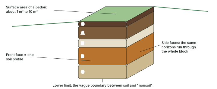
A profile is two-dimensional: a face on the wall of a pit. Soil scientists sample a three-dimensional unit instead, the pedon. Soil Taxonomy defines it as "the smallest volume for which one should describe and sample the soil to represent the nature and arrangement of its horizons" and compares it to "the unit cell of a crystal". Its lower limit is "the somewhat vague limit between the soil and 'nonsoil' below", and its "minimal horizontal area ... is arbitrarily set at 1 m², but it ranges to 10 m²", depending on how variable the soil is (Soil Taxonomy, 2nd ed., 1999). The profile is one face of the pedon (see the diagram below).
Remember
Profile = a vertical face showing the horizons (two-dimensional). Pedon = the smallest block of soil that shows them all (three-dimensional, about 1 m² to 10 m² in surface area).
The master horizons
NCERT's three horizons
NCERT describes three horizons over the rock. "‘Horizon A’ is the topmost zone, where organic materials have got incorporated with the mineral matter, nutrients and water, which are necessary for the growth of plants." "‘Horizon B’ is a transition zone between the ‘horizon A’ and ‘horizon C’, and contains matter derived from below as well as from above." "‘Horizon C’ is composed of the loose parent material." Underneath "is the rock which is also known as the parent rock or the bedrock". This is the version the examination expects, and it is a sound first picture.
The USDA master horizons and layers
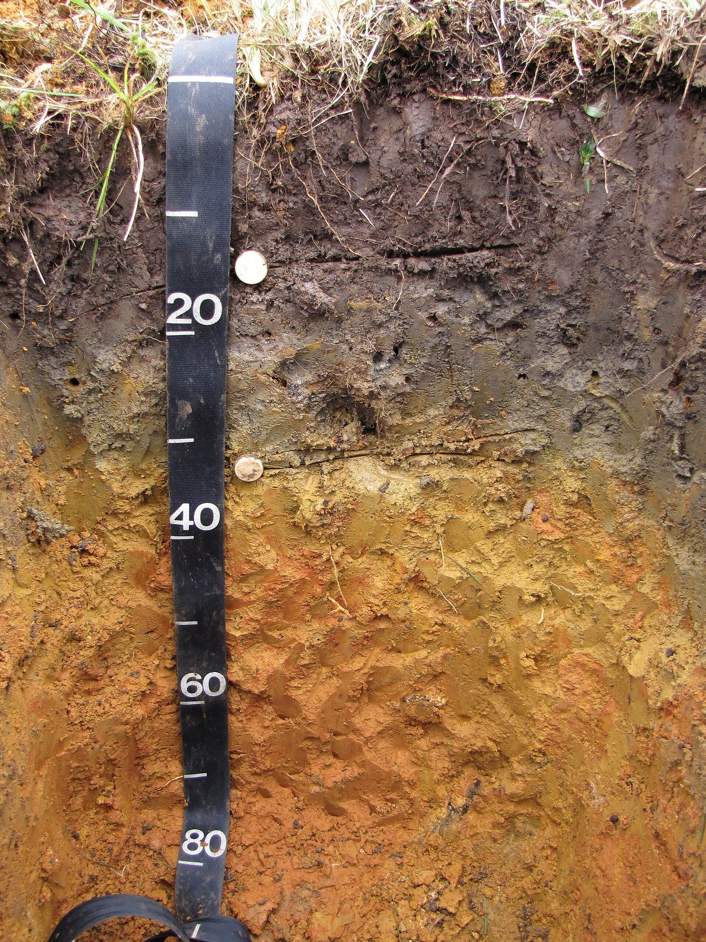
Soil surveyors need more detail. The USDA's Keys to Soil Taxonomy (13th ed., 2022) state that the "capital letters O, L, V, A, E, B, C, R, M, and W represent the master horizons and layers of soils". Six of the ten are the main ones met in most soils, in this order from the top: O, A, E, B, C, R (see the diagram below); the photo below it shows a real one. The other four are special cases: L for lake-bottom (limnic) materials, V for a surface horizon full of bubble-shaped (vesicular) pores in deserts, M for a root-limiting layer of human-manufactured material, and W for a water layer within or beneath the soil (see the table below).
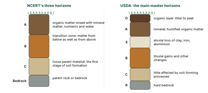
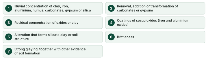
Three of the USDA definitions correct common misreadings. The A horizon is a mineral horizon at the surface or below an O horizon, marked by humified organic matter mixed with the mineral fraction. It is often the darkest layer in humid regions, but not always: "in warm, arid climates, the undisturbed surface horizon is less dark than the adjacent underlying horizon" (Keys, 2022). The B horizon is more than a layer where washed-in material collects. The Keys accept seven kinds of evidence of soil formation in it (see the diagram below), of which illuviation is only the first. The C horizon is wider than "partly decomposed bedrock": the Keys define C as mineral horizons or layers, "excluding strongly coherent and harder bedrock, that are little affected by pedogenic processes". Loose sediment counts as well as weathered rock: "Included as C layers (typically designated Cr) are sediment, saprolite, bedrock, and other geologic materials" that are no more than moderately coherent. The hard rock itself is the R layer, "strongly coherent to indurated bedrock" such as granite, basalt, quartzite, limestone and sandstone.
The ten USDA master horizons and layers
| Symbol | What it is (Keys to Soil Taxonomy, 2022) | Where you meet it |
|---|---|---|
| O | dominated by organic soil materials, from slightly (i) to highly (a) decomposed | forest floors; peat |
| L | limnic materials deposited in water or derived from aquatic plants (sedimentary peat, diatomaceous earth, marl) | old lake beds |
| V | surface mineral horizon dominated by vesicular pores, with platy, prismatic or columnar structure | at the surface, or below desert pavement |
| A | mineral horizon at the surface or below O; humified organic matter mixed with mineral matter, or changed by cultivation | almost every soil |
| E | "eluvial loss of silicate clay, iron, aluminum, or some combination of these, leaving a concentration of sand and silt particles" | leached soils, e.g. under forest |
| B | mineral horizon formed below an A, V, E or O horizon, with rock structure largely obliterated and evidence of pedogenesis | most mature soils |
| C | mineral layer, excluding hard bedrock, little affected by pedogenic processes | below B, or directly below A in young soils |
| R | strongly coherent to indurated bedrock | at the base where rock is shallow |
| M | root-limiting layer of "nearly continuous, horizontally oriented, human-manufactured materials" | urban and built-over soils |
| W | water layer within or beneath the soil surface | some permafrost soils (a frozen Wf layer) |
Source: USDA Soil Survey Staff, Keys to Soil Taxonomy, 13th ed. (2022), ch. 18 "Designations for Horizons and Layers". "Where you meet it" gives typical cases, not definitions.
Don't confuse: C horizon and R layer
C horizon = loose or weakly coherent material little changed by soil formation (sediment, saprolite). R layer = hard bedrock. NCERT calls C "the loose parent material" and puts "the parent rock or the bedrock" beneath it, which matches the USDA split.
Why it happens: The pale E horizon
The E horizon is pale because water passing through it has removed the clay, iron and aluminium that coat and colour the grains, "leaving a concentration of sand and silt particles" (Keys, 2022). What it lost usually turns up just below, in the B horizon (see leaching, eluviation and illuviation in the soil formation part).
Transitional horizons and suffixes
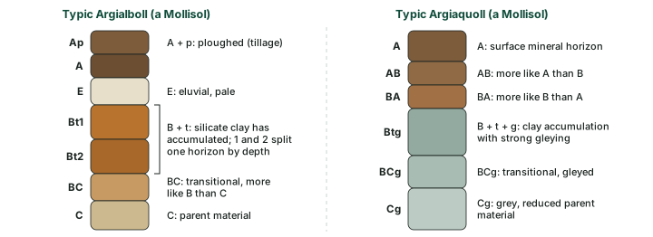
Real horizons rarely change abruptly. A layer that mixes the properties of two master horizons gets two capital letters, "e.g., AB, EB, BE, or BC", and the first letter names the one that dominates: "An AB horizon ... is more like the A horizon than the B horizon" (Keys, 2022). After the capital letters come lowercase suffixes for what has happened inside the horizon. A t in "Bt" means silicate clay has accumulated; a k in "Bk" means carbonates; a g means strong gleying. Arabic numbers then split one horizon by depth (Bt1, Bt2). The diagram below reads two designations taken from the Keys' own list of example profiles.
Common horizon suffixes
| Suffix | Meaning (Keys to Soil Taxonomy, 2022) | Typical use |
|---|---|---|
| a | highly decomposed organic material | Oa |
| b | buried genetic horizon | Ab, Btb |
| f | frozen soil or water (ff: dry permafrost) | Cf in permafrost |
| g | strong gleying | Bg, Cg |
| h | illuvial accumulation of organic matter | Bh, Bhs |
| jj | evidence of cryoturbation | Bjj in Gelisols |
| k | accumulation of secondary carbonates | Bk (calcic) |
| m | pedogenic cementation | Bkm (petrocalcic) |
| n | accumulation of sodium | Btn (natric) |
| o | residual accumulation of sesquioxides | Bo (oxic) |
| p | tillage or other disturbance | Ap |
| s | illuvial accumulation of metals complexed with organic matter | Bs (spodic) |
| ss | presence of slickensides | Bss in Vertisols |
| t | accumulation of silicate clay | Bt (argillic) |
| v | plinthite | Btv |
| w | development of colour or structure | Bw (cambic) |
| x | fragipan character | Btx |
| y | accumulation of gypsum | By (gypsic) |
| z | accumulation of salts more soluble than gypsum | Bz (salic) |
Source: USDA Soil Survey Staff, Keys to Soil Taxonomy, 13th ed. (2022), ch. 18 (suffix symbols). "Typical use" is a guide, not a definition.
Exam tip
Read a designation left to right: master horizon, then what happened, then the depth number. Btg2 = a B horizon (B) with clay accumulation (t) and strong gleying (g), second subdivision from the top (2).
How the profile changes with the setting
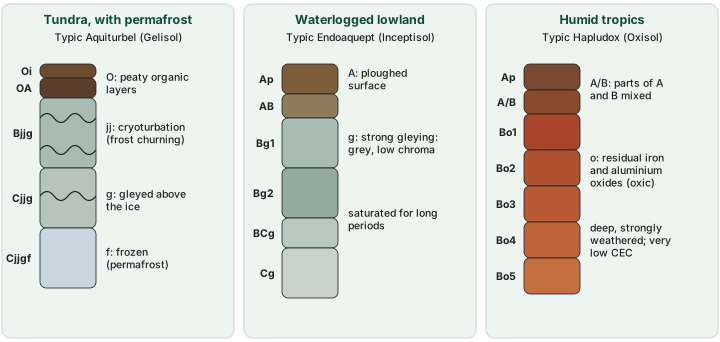
The processes of the soil formation part leave recognisable profiles. The two diagrams below draw six of them, each using a horizon sequence that the Keys give as an example for a real kind of soil. The setting named above each is the typical one, not part of the definition.
Under cool, humid forest litter builds an O horizon, and podzolisation strips iron and aluminium from the E horizon and deposits them, with organic matter, in a Bs (spodic) horizon. The Keys illustrate it with a profile from Michigan, USA, whose "light-colored albic horizon" extends to about 30 cm and "is underlain by a spodic horizon". Under grassland dense grass roots build a thick, dark, humus-rich surface: one example in the Keys is "a mollic epipedon more than 1 meter thick that formed on the steppes of the Ukraine". Below it, where rain cannot wash carbonates out of the profile, Bk and By horizons collect lime and gypsum. In deserts the surface is thin and pale, and lime collects in Btk or Bk horizons, and salts more soluble than gypsum can build a salic (z) horizon.
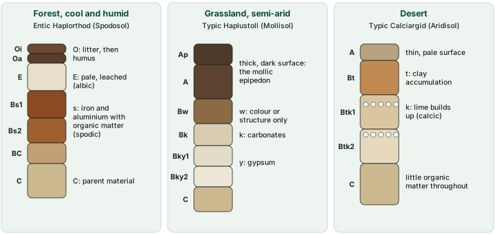
In the tundra the subsoil is permanently frozen. Freezing and thawing churn the soil above it. The Keys call this cryoturbation, "the mixing of the soil matrix within the pedon that results in irregular or broken horizons, involutions, accumulation of organic matter on the permafrost table", and mark it with the suffix jj; frozen layers carry f. In waterlogged ground the soil is starved of air, iron is reduced, and grey, low-chroma Bg and Cg horizons form (see gleying in the soil formation part). In the humid tropics long, intense weathering leaves deep Bo horizons in which iron and aluminium oxides have accumulated as residues: the oxic horizon, which is at least 30 cm thick and has a "very low cation-exchange capacity" (Soil Taxonomy, 1999).
Key idea: A record of water
Most profiles can be read as a record of water. Water moving down makes E and Bt, Bs or Bo horizons; water stopping part-way makes Bk and By; water rising and evaporating makes Bz; water standing still makes Bg and Cg; water frozen in place makes f and jj.
Diagnostic horizons
The letters A, E, B and so on are genetic horizons: they record a surveyor's judgement of how the soil formed. To classify soils consistently, Soil Taxonomy uses diagnostic horizons instead, defined by measurable limits of thickness, colour, clay content, base saturation and so on. The Keys are explicit: "The genetic horizons are not the equivalent of the diagnostic horizons of Soil Taxonomy." Diagnostic horizons at the surface are called epipedons; the others are subsurface horizons. An epipedon need not coincide with an A horizon either: "An epipedon is not the same as an A horizon" (Keys, 2022), and it can take in the top of the B horizon where the dark organic colour reaches that far (see the diagram below the table).
The table below lists the diagnostic horizons an aspirant should know. Three epipedons turn on colour and bases: the mollic epipedon is dark (Munsell value 3 or less and chroma 3 or less when moist) and rich in bases; the umbric epipedon "cannot be distinguished by the eye from a mollic epipedon", but its base saturation is below 50 per cent; and the ochric epipedon is the leftover class that fails the definitions of the others, "because it is too thin or too dry, has too high a color value or chroma, contains too little organic carbon". Below the surface, each subsurface horizon is the measured form of a process from the soil formation part.
Diagnostic horizons in Soil Taxonomy
| Horizon | Kind | Defining feature | Process behind it (soil formation) |
|---|---|---|---|
| Mollic | epipedon | thick, dark (value and chroma 3 or less, moist), base saturation 50% or more | humus build-up under grass |
| Umbric | epipedon | looks like mollic, but base saturation below 50% | humus build-up with leaching |
| Ochric | epipedon | fails the other epipedons: too thin, too light or too low in organic carbon | weak humus build-up |
| Albic | subsurface | light-coloured eluvial horizon | eluviation, podzolisation |
| Argillic | subsurface | "significantly higher percentage of phyllosilicate clay" than above, with evidence of clay illuviation | illuviation of clay |
| Natric | subsurface | an argillic horizon whose illuviation was "accelerated by the dispersive properties of sodium" | alkalisation |
| Spodic | subsurface | illuvial organic matter and aluminium, with or without iron; below O, A, Ap or E | podzolisation |
| Oxic | subsurface | at least 30 cm thick, strongly weathered, very low CEC | laterisation |
| Cambic | subsurface | "physical alterations, chemical transformations, or removals" | early weathering and structure |
| Calcic | subsurface | secondary carbonates; 15 cm or more thick, 15% calcium carbonate equivalent | calcification |
| Gypsic | subsurface | secondary gypsum accumulated to a significant extent | calcification in gypsum-rich dry lands |
| Salic | subsurface | salts "more soluble than gypsum in cold water"; 15 cm or more thick | salinisation |
Source: USDA Soil Survey Staff, Keys to Soil Taxonomy, 13th ed. (2022), ch. 3; USDA Soil Survey Staff, Soil Taxonomy, 2nd ed. (1999), ch. 3 (calcic, gypsic, oxic, umbric). Defining features are shortened: the full definitions have further limits.
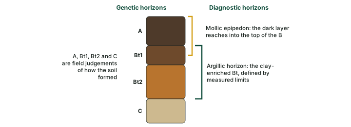
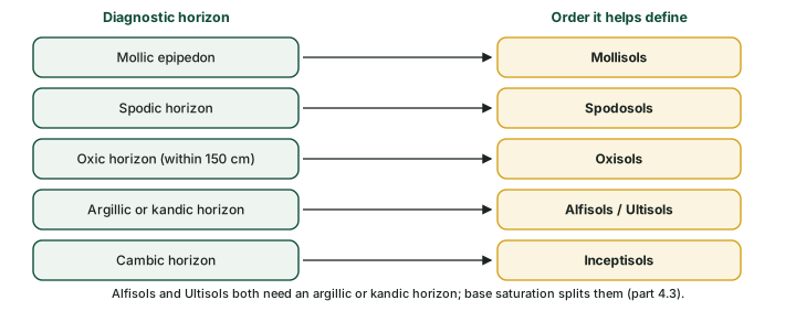
Several diagnostic horizons are the entry tickets to soil orders (see the diagram below): a mollic epipedon for Mollisols, a spodic horizon for Spodosols, an oxic horizon within 150 cm of the surface for Oxisols, an argillic or kandic horizon for both Alfisols and Ultisols, and a cambic horizon for many Inceptisols. The soil classification part follows this into the full key.
Don't confuse: Genetic and diagnostic horizons
Genetic horizon (A, E, Bt, Bk ...) = a field judgement of how a layer formed. Diagnostic horizon (mollic, argillic, spodic ...) = a layer that meets measured limits, used to classify the soil. A Bt horizon is often an argillic horizon, but only if it meets the limits.
Summary
A soil profile is the vertical face of a pedon, the small block of soil that shows all its horizons. NCERT's A, B and C horizons over bedrock become, in USDA terms, six main master horizons (O, A, E, B, C, R) out of ten, named with capital letters, transitional pairs, lowercase suffixes and depth numbers. Each setting writes its own profile, and the table below compares the six drawn in this part. For classification, Soil Taxonomy measures diagnostic horizons, which the soil classification part uses to sort soils into orders.
Profiles compared
| Setting | Example soil (order) | Key horizons | Main process | Defining feature |
|---|---|---|---|---|
| Cool, humid forest | Entic Haplorthod (Spodosol) | O, E, Bs | podzolisation | albic over spodic |
| Semi-arid grassland | Typic Haplustoll (Mollisol) | thick dark A, Bk, By | humus build-up, calcification | mollic epipedon |
| Desert | Typic Calciargid (Aridisol) | thin A, Bt, Btk | calcification | argillic, calcic |
| Tundra | Typic Aquiturbel (Gelisol) | O, Bjjg, Cjjgf | cryoturbation, gleying | permafrost |
| Waterlogged lowland | Typic Endoaquept (Inceptisol) | Bg, Cg | gleying | strong gleying (g) |
| Humid tropics | Typic Hapludox (Oxisol) | deep Bo | laterisation | oxic |
Source: horizon sequences from USDA Soil Survey Staff, Keys to Soil Taxonomy, 13th ed. (2022), ch. 18; each order read from the formative element of each soil name (soil classification). "Setting" is typical, not defining.
Sources
Each table and data figure names its source beneath it. The main documents are collected here, with a date where the source carries one. Figures not listed under image credits were drawn for this page from the sources stated in their source lines.
Main sources
| Topic | Source |
|---|---|
| Textbook | NCERT, India: Physical Environment, Class XI, 2020 edition, ch 6 (dropped from the current book) |
| Master horizons, suffixes, horizon sequences, epipedons and diagnostic horizons | USDA Soil Survey Staff, Keys to Soil Taxonomy, 13th ed. (2022) |
| Pedon; calcic, gypsic, oxic and umbric horizons | USDA Soil Survey Staff, Soil Taxonomy, 2nd ed. (1999) |
Image credits
| Image | Credit and licence |
|---|---|
| Soil Survey (20110505-SR-NRCS-002): the Dwarf soil series, El Yunque National Forest, Puerto Rico | USDAgov (US Department of Agriculture), May 2011. Public domain, via Wikimedia Commons. File page |
| All other figures | Drawn for this page from the sources given in their source lines. |


