 BharatNotes
Part 4 of 9 of the Soils and Biogeography notes. The overview page has the quick revision and exam strategy for all nine parts.
Soils of India
India's soils run from the river silts of the Ganga plain to the cracking clays of the Deccan and the leached, iron-rich laterites of the Peninsular uplands. NCERT sorts them into eight classes; the soil scientists who mapped the country use the USDA orders. This part teaches both, and shows why their numbers differ.
Cross-paper relevance
- GS1 (Geography, primary): how India's soils were surveyed and classified, soil area by USDA order and by traditional name, the eight NCERT soil classes, khadar and bhangar, regur and laterite
- GS3 (Agriculture): soil and Indian agriculture: which soils are short of nitrogen and phosphorus, irrigated arid soils, salinity from over-irrigation and the gypsum remedy; the Soil Health Card scheme is covered in soil degradation and conservation
How India's soils were classified
Indians sorted soils long before soil science existed. In ancient times soils were grouped as Urvara (fertile) and Usara (sterile). By the 16th century soils were classified by their own characteristics and outward features: texture (sandy, clayey, silty, loam), colour (red, yellow, black), the slope of the land and the moisture in the soil (NCERT).
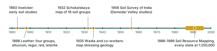
Scientific study began in the colonial period. A review by scientists of the National Bureau of Soil Survey and Land Use Planning (NBSS&LUP) traces it: the earliest investigations, by Voelcker, date back to 1893 and those by Leather to 1898, and together they grouped the country's soils into four: the Indo-Gangetic alluvium, the black cotton soil or regur, red soil and laterite soil. Schokalskaya published a soil map of India in 1932 following the Russian concept, with 16 soil groups based on climate, vegetation, soil-forming materials, salinity, alkalinity, swamps and peats, and in 1935 Wadia and his co-workers compiled a map that stressed geological formations (Bhattacharyya et al. 2013). Notice that the four oldest groups are still the backbone of every textbook list.
After Independence, the Soil Survey of India, established in 1956, studied soils in selected areas such as the Damodar Valley. The NBSS&LUP, an institute of the Indian Council of Agricultural Research (ICAR), then took the lead, and ICAR classified India's soils by the United States Department of Agriculture (USDA) Soil Taxonomy so that they could be compared with soils elsewhere (NCERT). NBSS&LUP mapped the country at 1:7 million at the level of sub-order associations, recognising one hundred and three soil sub-orders. Earlier syntheses had identified 16 major and 108 minor soil regions, brought under 27 units (Raychaudhari and co-workers), and a revised map had 23 major soil groups under the FAO/UNESCO World Soil Map project, later refined to 25 broad soil classes on a 1:7 million map. Large-scale mapping began in 1986 with a three-tier approach (image interpretation, field mapping and laboratory analysis); this Soil Resource Mapping programme covered the entire country between 1986 and 1996 and produced maps of every state and union territory at 1:250,000, while Sikkim, Goa, Lakshadweep, and the Andaman and Nicobar Islands were mapped at 1:50,000 (Bhattacharyya et al. 2013).
Remember
Soil Survey of India: 1956 (NCERT). NBSS&LUP works under ICAR and is the body behind India's soil maps. State-wise maps at 1:250,000 came from the mapping programme begun in 1986.
Two ways of counting India's soils
There are two official ways to divide up India's land by soil, and they give different numbers for what sounds like the same soil. Learn both, and learn why they differ.
By USDA soil order
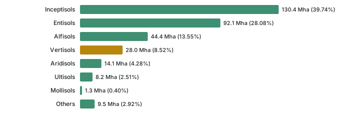
NCERT prints a table of India's area by USDA soil order, citing NBSS&LUP's Soils of India (Publication Number 94). Soil classification explains what each order means. Two orders dominate: Inceptisols (39.74%) and Entisols (28.08%) together cover about two-thirds of the country (67.82%, computed). Vertisols, the cracking clays, come fourth.
India's area by USDA soil order (NCERT, citing NBSS&LUP Publication 94)
| Order | Area, thousand ha | Area, million ha | Per cent |
|---|---|---|---|
| Inceptisols | 130,372.90 | 130.4 | 39.74 |
| Entisols | 92,131.71 | 92.1 | 28.08 |
| Alfisols | 44,448.68 | 44.4 | 13.55 |
| Vertisols | 27,960.00 | 28.0 | 8.52 |
| Aridisols | 14,069.00 | 14.1 | 4.28 |
| Ultisols | 8,250.00 | 8.2 | 2.51 |
| Mollisols | 1,320.00 | 1.3 | 0.40 |
| Others | 9,503.10 | 9.5 | 2.92 |
| Total | 328,055.39 (computed) | 328.1 | 100 |
Source: NCERT, India: Physical Environment, Class XI, 2020 edition, ch 6 "Soils" (dropped from the current book), which cites "Soils of India", NBSS&LUP Publication Number 94. Areas in million ha computed (thousand ha / 1,000). The total area is computed by adding the rows; NCERT prints only "Total 100".
By traditional name
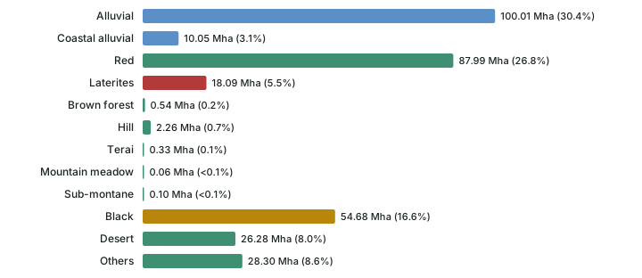
The 1:250,000 soil maps and their legends do not show the traditional names, and "Latin names may not be decipherable by many scientists and end-users", so the NBSS&LUP scientists also reported the area under the familiar names. Their 2013 review reduced the 24 major soil groups of an earlier study to 11, and admitted the difficulty: "We faced a problem to classify soils as red, laterites and hilly since at many places these names overlap." The table below gives their figures.
Major soils of India by traditional name, from the 1:250,000 soil maps
| Soil (traditional name) | Area, thousand ha | Per cent | States | Nearest USDA orders |
|---|---|---|---|---|
| Alluvial | 100,006 | 30.4 | J&K, HP, Punjab, Haryana, Delhi, UP, Gujarat, Goa, MP, MS, AP, Karnataka, TN, Kerala, Puducherry, Bihar, Odisha, WB, ArP, Assam, Nagaland, Manipur, Mizoram, Tripura, Meghalaya, A&N | Inceptisols, Entisols, Alfisols, Aridisols |
| Coastal alluvial | 10,049 | 3.1 | AP, Karnataka, TN, Kerala, WB, Gujarat, Odisha, Puducherry, Lakshadweep, A&N | Aridisols, Inceptisols, Entisols |
| Red | 87,989 | 26.8 | AP, Karnataka, Kerala, TN, Puducherry, Rajasthan, MP, MS, Gujarat, Goa, ArP, Assam, Manipur, Meghalaya, Nagaland, Mizoram, Tripura, Delhi, UP, HP, A&N | Alfisols, Ultisols, Entisols, Inceptisols, Mollisols, Aridisols |
| Laterites | 18,094 | 5.5 | AP, Karnataka, Kerala, TN, Puducherry, MS, Odisha, WB | Alfisols, Ultisols, Inceptisols |
| Brown forest | 540 | 0.2 | Karnataka, Maharashtra | Mollisols, Inceptisols |
| Hill | 2,262 | 0.7 | Manipur, Odisha, WB, Tripura, Nagaland | Inceptisols, Entisols |
| Terai | 326 | 0.1 | UP, Sikkim | Mollisols, Entisols |
| Mountain meadow | 60 | <0.1 | J&K | Mollisols |
| Sub-montane | 104 | <0.1 | J&K | Alfisols |
| Black | 54,682 | 16.6 | MP, MS, Rajasthan, Puducherry, TN, UP, Bihar, Odisha, AP, Gujarat | Vertisols, Mollisols, Inceptisols, Entisols, Aridisols |
| Desert | 26,283 | 8.0 | Rajasthan, Gujarat, Haryana, Punjab | Aridisols, Inceptisols, Entisols |
| Others | 28,305 | 8.6 | (glaciers, rock outcrops, water bodies, mangrove swamps, salt waste, dunes) | - |
| Total | 328,700 | 100 |
Source: Bhattacharyya, Pal, Mandal, Chandran, Ray, Sarkar et al., "Soils of India: historical perspective, classification and recent advances", Current Science 104(10): 1308-1323, 25 May 2013, Table 1, p. 1309 (state abbreviations as printed; "Others" also includes rock outcrops, 7.8% of the country).
Don't confuse: 40% and 30.4%
"Alluvial soils cover about 40% of India" is NCERT's figure. The NBSS&LUP 1:250,000 table gives 30.4% for alluvial soils, plus 3.1% for a separate "coastal alluvial" class. The bases differ: NCERT gives a rounded textbook share for all alluvium; the 2013 table measures mapped units and splits coastal alluvium off. In an exam set from NCERT, about 40% is the expected answer; know that the mapped figure is lower.
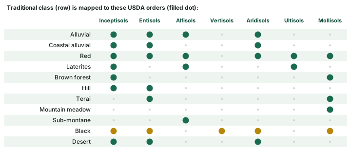
The two tables cannot be matched row for row, because one traditional class spreads over several USDA orders. The review's table lists the nearest orders for each class (diagram below). Alluvial soils, for example, fall in four orders, and the black soils in five.
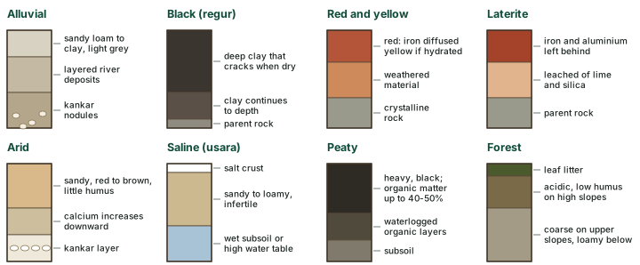
Alluvial soils
Formation. Alluvial soils are depositional: rivers and streams carry the material and lay it down. They are widespread in the northern plains and the river valleys, reach the plains of Gujarat through a narrow corridor in Rajasthan, and in the Peninsula occur in the deltas of the east coast and in the river valleys (NCERT).
Properties. They range from sandy loam to clay. They are generally rich in potash but poor in phosphorus. They become more loamy and clayey in the lower and middle Ganga plain and the Brahmaputra valley, because the sand content decreases from west to east. Their colour runs from light grey to ash grey, depending on the depth of deposition, the texture and how long the soil has had to mature. Alluvial soils are intensively cultivated (NCERT).
Khadar and bhangar
In the Upper and Middle Ganga plain two kinds of alluvium have developed. Khadar is the new alluvium, deposited by floods every year, which renews the soil with fine silt. Bhangar is the older alluvium, laid down away from the present flood plains. Both contain calcareous concretions called kankar (NCERT). The difference is one of age and position: floods still reach the khadar, but the bhangar lies away from the flood plains.
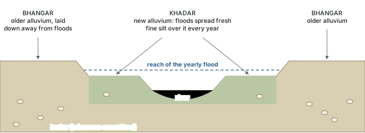
Don't confuse: khadar and bhangar
Khadar = new alluvium, flooded every year, fine silt. Bhangar = older alluvium, deposited away from the flood plains. Both carry kankar (NCERT). Terai soils are a separate, small class in the 2013 NBSS&LUP table (0.1%), mapped in Uttar Pradesh and Sikkim.
Black soils (regur)
Where. Black soil covers most of the Deccan Plateau, including parts of Maharashtra, Madhya Pradesh, Gujarat, Andhra Pradesh and some parts of Tamil Nadu. It is very deep in the upper reaches of the Godavari and the Krishna and in the north-western Deccan (NCERT). The NBSS&LUP review adds that Maharashtra, Madhya Pradesh and Gujarat have the major share of black soils in the country.
Names and properties. These soils are also called regur or black cotton soil. They are generally clayey, deep and impermeable. They swell and become sticky when wet and shrink when dry, so wide cracks open in the dry season; soil from the surface falls into the cracks, a kind of "self-ploughing". Because they take in and lose moisture slowly, they hold water for a very long time, which helps crops, especially rain-fed ones, through the dry season. Chemically they are rich in lime, iron, magnesia and alumina, and contain potash, but lack phosphorus, nitrogen and organic matter. Their colour ranges from deep black to grey (NCERT).
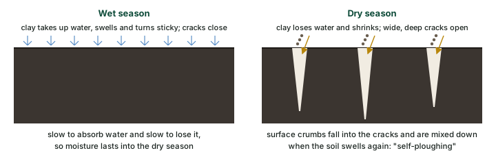
Why it happens. The NBSS&LUP review explains the mechanism in the language of soil science: black soils are usually deep to very deep and dominated by smectitic clays, the clays that swell when they take up water. They have slickensides or wedge-shaped peds, at least 30% clay, and cracks that open and close periodically, and such soils are grouped as Vertisols (Bhattacharyya et al. 2013).
Black soil is not the same as Vertisol
Here the two counting systems described above collide. Vertisols are 8.52% of India in NCERT's order table; the traditional "black" class is 16.6% of the mapped area; and the same review reports a revised estimate of nearly 76.4 million ha of black soils. The numbers differ because the bases differ. Many soils with the shrink-swell character are not Vertisols but "vertic intergrades" of other orders, and the review notes that such soils can even be red in colour, so that "the term black soils for Vertisols and vertic intergrades is technically wrong" (Bhattacharyya et al. 2013).

Don't confuse: regur and Vertisol
Regur and black cotton soil are Indian names for the black soils. Vertisol is a USDA order defined by its cracking clay, not by colour. Most regur is Vertisol or close to it, but the areas are not equal: Vertisols 8.52% (order table) against black soils 16.6% (traditional table).
Red and yellow soils
Formation and places. Red soil develops on crystalline igneous rocks in areas of low rainfall in the eastern and southern Deccan. A long stretch along the piedmont zone of the Western Ghats carries red loamy soil, and yellow and red soils also occur in parts of Odisha and Chhattisgarh and in the southern parts of the middle Ganga plain (NCERT). In the 2013 table red soils are the second largest class (26.8%) and are mapped in more than twenty states and union territories.
Colour and fertility. The red colour comes from the wide diffusion of iron through crystalline and metamorphic rocks; the same soil looks yellow when the iron is hydrated. Fine-grained red and yellow soils are normally fertile, but the coarse-grained soils of dry uplands are poor. They are generally poor in nitrogen, phosphorus and humus (NCERT).
Why it happens
The colour comes from iron. Iron diffused widely through the crystalline and metamorphic rock makes the soil red, and NCERT adds that the same soil "looks yellow when it occurs in a hydrated form". Red and yellow are therefore one class, not two.
Laterite soils
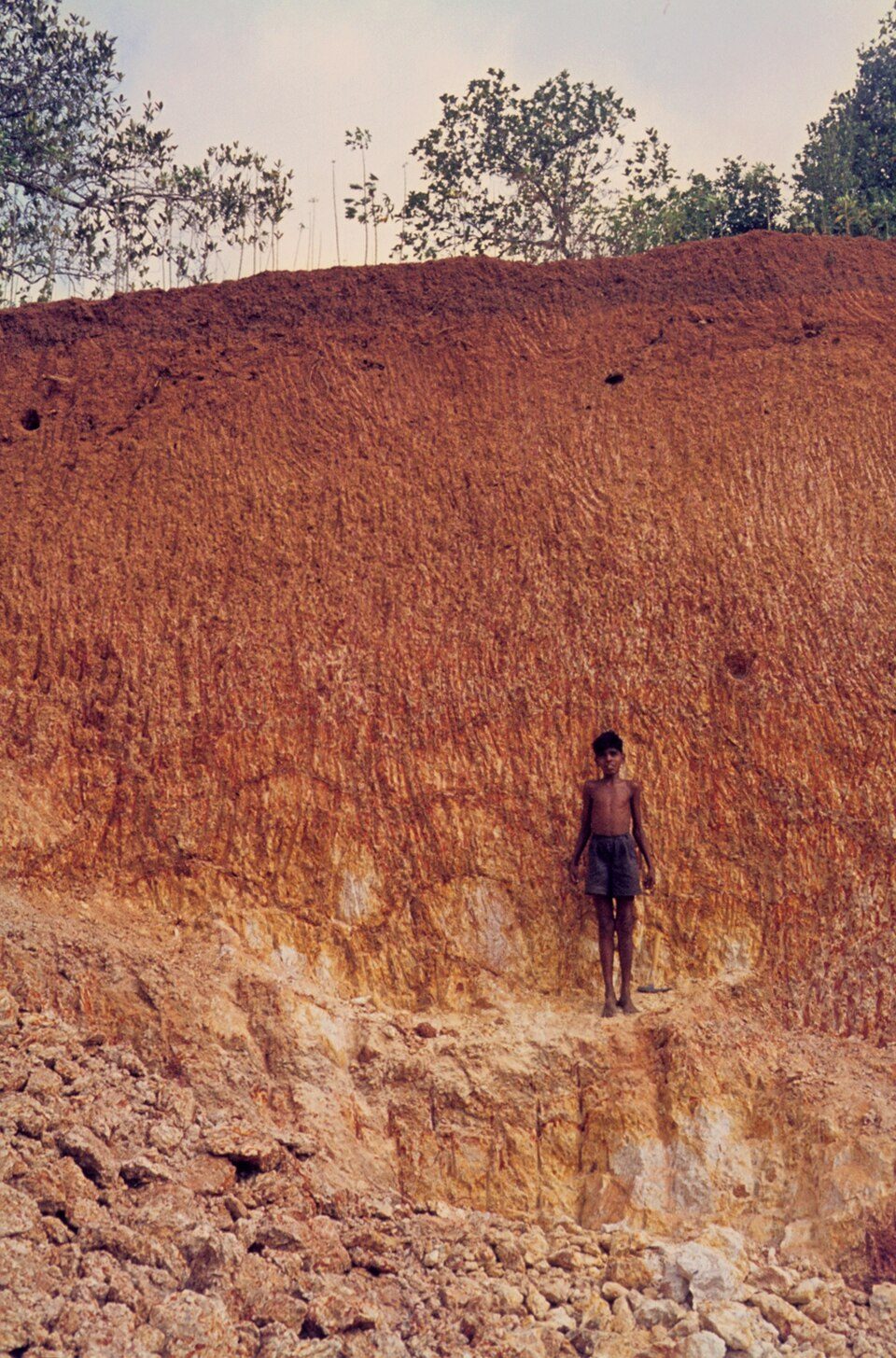
The name. "Laterite" comes from the Latin later, a brick (NCERT), and laterite is still widely cut as bricks for house construction.
Formation. Laterite soils form where both temperature and rainfall are high. They are the result of intense leaching by tropical rain: lime and silica are carried away, leaving soils rich in iron oxide and aluminium compounds. Humus is removed fast by bacteria that thrive in the heat (NCERT). Soil formation explains laterisation as a soil-forming process and sets it beside podzolisation and calcification.
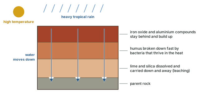
Properties and use. Laterite soils are poor in organic matter, nitrogen, phosphate and calcium, while iron oxide and potash are in excess. They are therefore not suitable for cultivation without manures and fertilisers. Red laterite soils in Tamil Nadu, Andhra Pradesh and Kerala are better suited to tree crops such as cashew. Laterite is widely cut as bricks for house construction. These soils developed mainly on the higher areas of the Peninsular plateau (NCERT).
Where laterite soils occur: textbook and mapping
| Source | States named |
|---|---|
| NCERT (textbook) | Karnataka, Kerala, Tamil Nadu, Madhya Pradesh, and the hilly areas of Odisha and Assam |
| NBSS&LUP 2013 (1:250,000 maps) | Andhra Pradesh, Karnataka, Kerala, Tamil Nadu, Puducherry, Maharashtra, Odisha, West Bengal |
Source: NCERT, India: Physical Environment, Class XI, 2020 edition, ch 6 "Soils" (dropped from the current book); Bhattacharyya, Pal, Mandal, Chandran, Ray, Sarkar et al., "Soils of India: historical perspective, classification and recent advances", Current Science 104(10): 1308-1323, 25 May 2013, Table 1. The lists differ; quote NCERT's in an NCERT-based answer.
In the USDA system laterites fall under Alfisols, Ultisols and Inceptisols (see the traditional-name table above). The review calls the Ultisols of Kerala "popularly known as laterites" and notes that they are "considered to be international reference for laterite" (Bhattacharyya et al. 2013).
Arid soils
Arid soils range from red to brown. They are generally sandy and saline; in some areas the salt content is so high that common salt is obtained by evaporating the saline water. The dry climate, high temperature and fast evaporation leave them short of moisture and humus. Nitrogen is insufficient and phosphate is normal. Calcium increases downward, so the lower horizons hold kankar layers; these restrict the infiltration of water, so that when irrigation is available the moisture stays within reach of plants. Arid soils are characteristic of western Rajasthan (NCERT). The 2013 table's "Desert" class (8.0%) lies in Rajasthan, Gujarat, Haryana and Punjab and maps mostly to Aridisols.
Exam tip
Link the kankar layer to irrigation: because it restricts infiltration, irrigation water stays in the root zone and the soil moisture is "readily available for a sustainable plant growth" (NCERT). That is the reason irrigated arid soils can be productive.
Saline soils
Saline soils, also called Usara soils, contain a large proportion of sodium, potassium and magnesium; they are infertile and support no vegetation. They collect salt because of dry climate and poor drainage, and occur in arid and semi-arid regions and in waterlogged and swampy areas. Their texture ranges from sandy to loamy, and they lack nitrogen and calcium (NCERT).
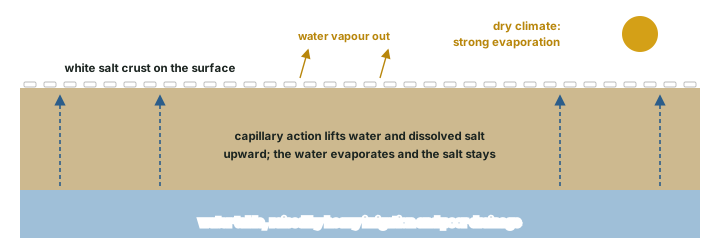
NCERT names three settings. In western Gujarat, in the Rann of Kachchh, the south-west monsoon brings salt particles that are deposited as a crust. In the deltas of the east coast and the Sunderbans of West Bengal, seawater intrusion makes soils saline. And in the areas of intensive irrigation, especially of the Green Revolution, fertile alluvial soils are turning saline: excessive irrigation in a dry climate drives capillary action, which deposits salt on the top layer. In Punjab and Haryana farmers are advised to add gypsum to tackle the problem (NCERT). Soil degradation and conservation returns to salinisation as a form of land degradation.
Peaty and forest soils
Peaty soils form where heavy rainfall and high humidity support a good growth of vegetation, so that a large quantity of dead organic matter accumulates and gives the soil a rich humus and organic content. Their organic matter "may go even up to 40-50 per cent". They are normally heavy and black, and alkaline in many places. They occur widely in northern Bihar, southern Uttarakhand and the coastal areas of West Bengal, Odisha and Tamil Nadu (NCERT). Soil classification describes Histosols, the USDA order for organic soils; NCERT's order table has no Histosol row.
Forest soils form in forest areas with enough rainfall. Their texture depends on the mountain setting: loamy and silty on valley sides, coarse-grained on the upper slopes. In the snow-bound Himalaya they suffer denudation and are acidic with little humus, while the soils of the lower valleys are fertile (NCERT). The 2013 table has no single "forest" class; it lists small brown forest, hill, terai, mountain meadow and sub-montane classes.
Soil and Indian agriculture
Read the eight classes as a farmer would. Alluvial soils, renewed by floods on the khadar, are intensively cultivated. Black soils carry rain-fed crops through the dry months because they hold water. Red soils are fertile where they are fine-grained and poor on coarse dry uplands. Laterites need manure and fertiliser and suit tree crops such as cashew. Arid soils become productive when irrigated, but irrigation in a dry climate is exactly what turns good alluvium saline (NCERT). Six of the eight classes are described as short of nitrogen, phosphorus or both; soil degradation and conservation describes the Soil Health Card scheme, which tests soils for these nutrients.
Key idea
India's soils are taught in two languages. The traditional names (alluvial, black, red, laterite...) describe colour, origin and place; the USDA orders (Inceptisols, Entisols, Vertisols...) describe measured horizons and properties. One traditional class spans several orders, so their areas never match.
The eight NCERT soil classes compared
| Class | Formed by / where | Character | Rich in | Poor in | Main areas (NCERT) | Use (NCERT) |
|---|---|---|---|---|---|---|
| Alluvial | deposited by rivers | sandy loam to clay; khadar and bhangar; kankar | potash | phosphorus | northern plains, river valleys, east-coast deltas | intensively cultivated |
| Black (regur) | Deccan plateau | clayey, deep, cracks when dry, holds moisture | lime, iron, magnesia, alumina, potash | phosphorus, nitrogen, organic matter | Maharashtra, MP, Gujarat, Andhra Pradesh, parts of Tamil Nadu | rain-fed crops |
| Red and yellow | on crystalline igneous rocks, low rainfall | red from diffused iron, yellow when hydrated | - | nitrogen, phosphorus, humus | eastern and southern Deccan, Western Ghat piedmont, Odisha, Chhattisgarh | fertile if fine-grained |
| Laterite | intense leaching, high heat and rain | iron and aluminium rich; cut as bricks | iron oxide, potash | organic matter, nitrogen, phosphate, calcium | Karnataka, Kerala, Tamil Nadu, MP, hilly Odisha and Assam | cashew with manure; bricks |
| Arid | dry climate, fast evaporation | sandy, saline, kankar below | phosphate normal | moisture, humus, nitrogen | western Rajasthan | productive when irrigated |
| Saline (usara) | dry climate, poor drainage, seawater, over-irrigation | salt crust; sandy to loamy | sodium, potassium, magnesium | nitrogen, calcium | western Gujarat, east-coast deltas, Sunderbans, Punjab, Haryana | infertile; gypsum advised |
| Peaty | heavy rain, humidity, rich vegetation | heavy, black, often alkaline | organic matter (to 40-50%) | - | north Bihar, south Uttarakhand, coastal WB, Odisha, Tamil Nadu | - |
| Forest | forest areas with rainfall | loamy-silty in valleys, coarse on slopes; acidic high up | - | humus (snow-bound Himalaya) | forest areas with enough rain; the Himalaya | fertile in lower valleys |
Compiled from NCERT, India: Physical Environment, Class XI, 2020 edition, ch 6 "Soils" (dropped from the current book). "-" means NCERT gives nothing for that cell.
Summary
- Ancient India knew Urvara and Usara; Voelcker (1893) and Leather (1898) gave four groups; the Soil Survey of India dates from 1956; NBSS&LUP (ICAR) mapped every state at 1:250,000 from 1986.
- By USDA order, Inceptisols (39.74%) and Entisols (28.08%) lead (NCERT, citing NBSS&LUP Publication 94).
- By traditional name, alluvial soils cover about 40% in NCERT and 30.4% (+3.1% coastal) in the 2013 NBSS&LUP table.
- Khadar is new, flooded alluvium; bhangar is older alluvium beyond the floods; both have kankar.
- Regur is clayey and self-ploughing; black soils (16.6%) are not the same as Vertisols (8.52%).
- Laterite (Latin later, brick) is a leached, iron- and aluminium-rich soil of hot, wet uplands.
- Saline soils come from dry climate, poor drainage, sea water and over-irrigation; gypsum is the advised remedy.
Sources
Each table and data figure names its source beneath it. The main documents are collected here, with a date where the source carries one. Figures not listed under image credits were drawn for this page from the sources stated in their source lines.
Main sources
| Topic | Source |
|---|---|
| Textbook account of India's soil classes | NCERT, India: Physical Environment, Class XI, 2020 edition, ch 6 "Soils" (dropped from the current book) |
| India's area by USDA soil order | NCERT, as above, citing "Soils of India", NBSS&LUP Publication Number 94 |
| History of soil survey, traditional-name areas, black soils and Vertisols, laterites | Bhattacharyya, Pal, Mandal, Chandran, Ray, Sarkar et al., "Soils of India: historical perspective, classification and recent advances", Current Science 104(10): 1308-1323, 25 May 2013 |
Image credits
| Image | Credit and licence |
|---|---|
| Lateritic weathering section on granitic gneiss, Trivandrum, Kerala | Werner Schellmann. CC BY-SA 2.5. File page |
| Cutting of laterite brickstones, Angadipuram | Werner Schellmann. CC BY-SA 2.5. File page |
| All other figures | Drawn for this page from the sources given in their source lines. |



