 BharatNotes
Part 1 of 9 of the Soils and Biogeography notes. The overview page has the quick revision and exam strategy for all nine parts.
Soil: Its Nature and Formation
Soil is the thin, living skin of the land. It feeds almost every crop we grow, stores water, and records in its layers the climate and vegetation it has lived under. This part explains what soil is made of, how its texture, structure, colour and chemistry are described, and how climate, organisms, relief, parent material and time turn bare rock into soil through a small set of processes.
What soil is
NCERT gives the definition most examinations expect: "Soil is the mixture of rock debris and organic materials which develop on the earth's surface." It adds that the soil we depend on "has evolved over thousands of years", as "the various agents of weathering and gradation have acted upon the parent rock material to produce a thin layer of soil" (NCERT, India: Physical Environment, Class XI, 2020 edition, ch 6 (dropped from the current book)).
Soil scientists use a stricter definition. The USDA's Keys to Soil Taxonomy (13th edition, 2022) calls soil "a natural body comprised of solids (minerals and organic matter), liquid, and gases that occurs on the land surface, occupies space, and is characterized by one or both of the following: horizons, or layers, that are distinguishable from the initial material ... or the ability to support rooted plants in a natural environment". The two definitions agree on the ingredients. The USDA one adds the test that matters to a scientist: a soil has either developed layers of its own or can carry plants. A heap of freshly crushed rock has the ingredients but neither property yet.
The study of soil has two broad branches. Pedology deals with "the origin, morphology, genesis, distribution, mapping, and taxonomy of soils, and classification in terms of their use"; edaphology is "the science that deals with the influence of soils on living things, particularly plants including man's use of land for plant growth" (both definitions from the Canadian Soil Information Service glossary, Agriculture and Agri-Food Canada). A pedologist asks how a soil formed and what it should be called; an edaphologist asks what it will grow.
Don't confuse: Pedology and edaphology
Pedology studies soil as a natural body (origin, profile, classification, mapping). Edaphology studies soil as a medium for living things, chiefly plants. The word "edaphic" (as in edaphic factors in ecology) comes from the second.
- 4 components of soil in NCERT: mineral particles, humus, water, air
- 3 fine-earth fractions: sand, silt, clay
- 12 USDA soil texture classes
- 5 + ... state factors in Jenny's equation, an open list
What soil is made of
NCERT names four components: "mineral particles, humus, water and air". It adds that "the actual amount of each of these depend upon the type of soil. Some soils are deficient in one or more of these, while there are some others that have varied combinations" (NCERT, India: Physical Environment, Class XI, 2020 edition, ch 6 (dropped from the current book)). The diagram below shows how they fit together. The mineral grains form a framework; organic matter coats and binds them; the spaces between the grains, the pores, hold either water or air. After rain the pores fill with water; as the soil drains and dries, air takes their place. Water and air therefore compete for the same space, and a soil can have too much of one only by having too little of the other.
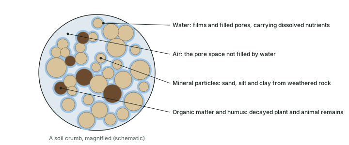
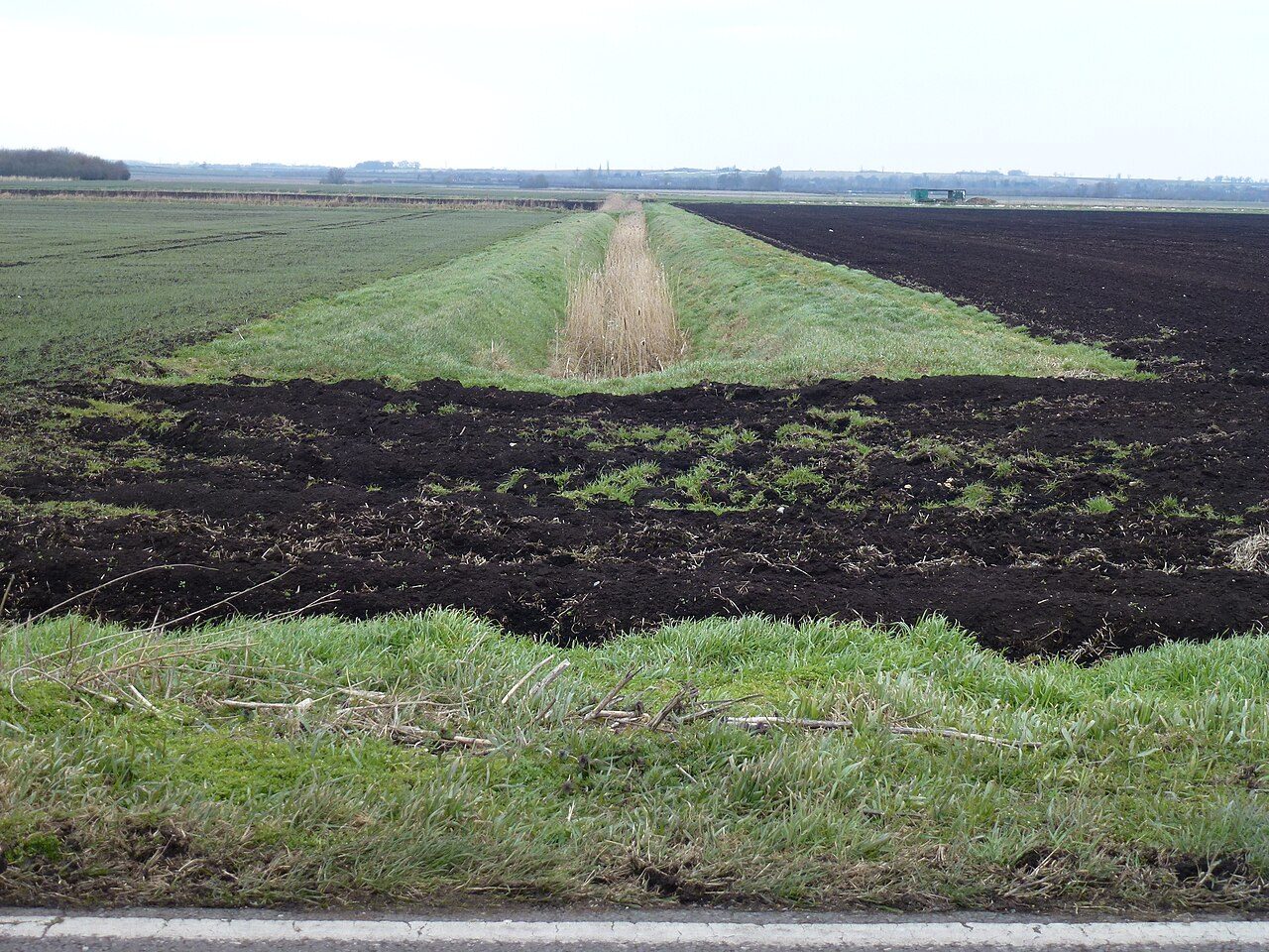
Mineral matter comes from the weathering of rock (weathering itself belongs to geomorphology). Organic matter is the remains of plants, animals and microbes at every stage of decay. Its well-decomposed, dark and fairly stable part is humus. Humus darkens the soil, binds grains into crumbs, holds water and holds nutrient cations (see the chemical properties, below). The Keys draw the line between mineral and organic soil material at organic carbon: soil material with less than 12 per cent organic carbon by weight is mineral; 12 per cent organic carbon is "approximately equal to 20 percent organic matter". Peat, which is mostly organic, is treated as a separate kind of soil, the Histosols, in the soil classification part. The photo below shows how dark a peat soil can be.
Remember
NCERT's four components: mineral particles, humus, water and air. The Keys' threshold: soil material below 12% organic carbon (about 20% organic matter) is mineral soil material.
Physical properties
Texture
Texture is the proportion of sand, silt and clay in the fine earth, the part of the soil finer than 2 mm. The USDA limits are: clay below 0.002 mm, silt 0.002 to 0.05 mm, sand 0.05 to 2.0 mm (Keys to Soil Taxonomy, 2022). Silt and clay are too fine to sieve, so laboratories separate them by "differential rate of settling in water": coarse particles sink faster. The international standard ISO 11277, which the WRB manual tabulates, puts the sand-silt boundary a little higher, at 0.063 mm. The diagram below sets the two scales side by side; the clay limit of 0.002 mm is the same in both.
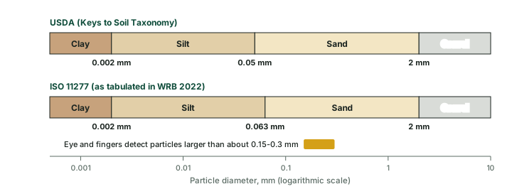
Particle-size classes in two schemes
| Fraction | USDA (Keys to Soil Taxonomy, 2022) | ISO 11277 (WRB 2022, Table 8.38) | How it feels |
|---|---|---|---|
| Sand | 0.05 to 2.0 mm | over 0.063 to 2 mm | gritty; grains visible |
| Silt | 0.002 to 0.05 mm | over 0.002 to 0.063 mm | smooth, floury when dry |
| Clay | below 0.002 mm | 0.002 mm or less | sticky and plastic when wet |
Source: USDA Soil Survey Staff, Keys to Soil Taxonomy, 13th ed. (2022), Appendix; IUSS Working Group WRB, World Reference Base for Soil Resources, 4th ed. (2022, errata 2024), Table 8.38. "How it feels" is the usual field description, a guide only.
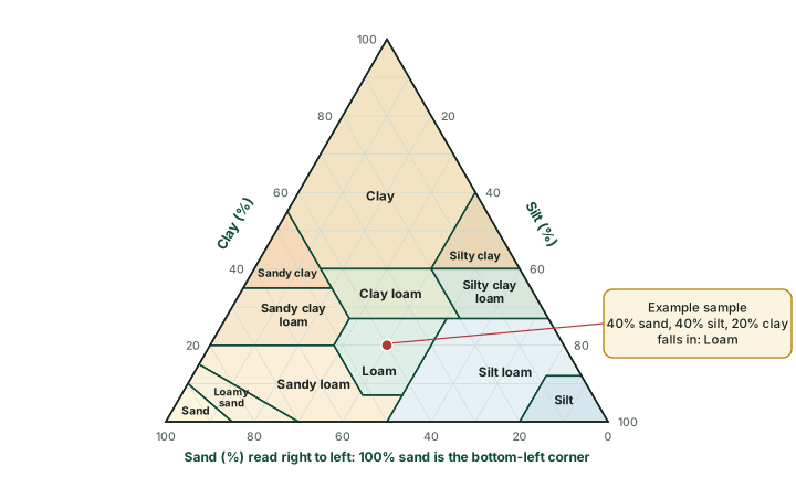
Because the three fractions always add up to 100 per cent, any soil can be plotted as one point on a triangle. The USDA divides the triangle into 12 texture classes (see the diagram below), following the Soil Survey Manual (Soil Science Division Staff, 2017). Loam is the middle ground, a mixture in which no fraction dominates. NCERT records that in India in the 16th century soils were already grouped by texture into "sandy, clayey, silty and loam", the same idea in plain words. Texture matters because it controls almost everything else: sandy soils drain fast and hold little water and few nutrients; clayey soils hold water and nutrients but drain slowly and can become waterlogged; loams combine the strengths of both.
Worked example: Naming a texture
A soil sample has 40% sand, 40% silt and 20% clay. Name its texture class.
- Check the total: 40 + 40 + 20 = 100%.
- Clay is 20%: between 7% and 27%, so the soil lies in the lower-middle band of the triangle.
- Silt is 40%: between 28% and 50%. Sand is 40%: not more than 52%.
- Those three conditions together are the definition of loam.
Answer: Loam (the red point in the texture triangle above).
Structure
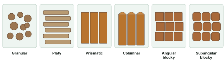
Texture describes the individual grains; structure describes how they are grouped. In most soils the grains cling together into aggregates called peds, separated by cracks and pores. Field descriptions name the shapes shown in the diagram below: crumb-like granular peds, flat platy ones, tall prismatic and columnar ones (columns have rounded tops), and cube-like blocky peds with sharp or rounded corners. A soil with no peds at all is single-grained (loose sand) or massive (one coherent mass). Structure matters as much as texture for farming: the gaps between peds are the paths along which water drains, air enters and roots grow, so a well-aggregated clay can behave far better than its texture alone suggests.
Colour and the Munsell idea
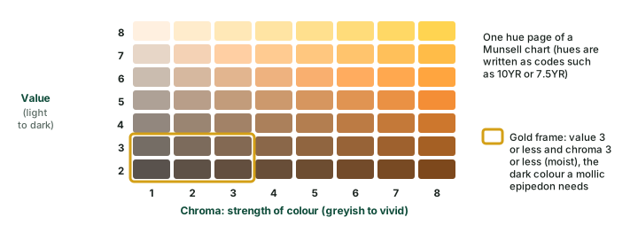
Colour is the first thing anyone notices in a soil pit, and it is a useful clue. Dark colours usually mean humus; red and yellow mean iron oxides; grey and bluish colours mean iron has been reduced under waterlogging (see gleying, below); white streaks can be lime or salts. To make colour objective, soil scientists match a sample against the chips of a Munsell soil colour chart, which describes every colour by three numbers: hue (the basic colour, written as a code such as 10YR or 7.5YR), value (lightness, from dark to light) and chroma (strength, from greyish to vivid). The Keys state that "soil colors (hue, value, and chroma) are used in many of the taxonomic criteria". The mollic epipedon of grassland soils, for example, must be dark: a Munsell value of 3 or less and chroma of 3 or less when moist (see the diagram below; the soil profile part explains epipedons).
Porosity and permeability
Porosity is the share of a soil's volume taken up by pores; permeability is how easily water and air pass through it. The two are not the same. A clay has a great many tiny pores, so its total porosity can be high, yet water moves through such narrow channels only slowly. A sand has fewer but wider pores and drains quickly. Structure adds a second set of larger pores between peds, which is why ploughing, compaction or the loss of humus changes permeability so much. A hard layer stops water altogether: NCERT notes that the 'kankar' layer in the arid soils of western Rajasthan "restricts the infiltration of water", so that irrigation water stays within reach of plant roots.
Chemical properties
Soil reaction (pH)
pH measures how acid or alkaline the soil water is, on a scale on which 7 is neutral, lower values are acid and higher values alkaline. Laboratories measure it in a 1:1 mixture of soil and water, and also in salt solutions (potassium chloride, calcium chloride), which give slightly different readings (Keys, 2022). pH matters because it controls which nutrients dissolve. In strongly acid soils aluminium comes into solution: the Keys treat extractable aluminium as "a measure of the 'active' acidity present in soils" whose 1:1 water pH is about 5.5 or lower. NCERT gives Indian cases at both ends: the forest soils of the snow-bound Himalaya "are acidic with low humus content", while peaty soils are "alkaline also" at many places and saline soils "contain a larger proportion of sodium, potassium and magnesium".
Cation exchange capacity and base saturation
Clay particles and humus carry negative electric charges on their surfaces. These charges attract and hold positively charged ions (cations) such as calcium, magnesium, potassium and sodium, and also hydrogen and aluminium. The cations are held loosely: one can be swapped for another in the soil water, which is how plant roots draw nutrients from the soil. The total amount of exchangeable cations a soil can hold is its cation exchange capacity (CEC), measured in centimoles of positive charge per kilogram, cmol(+)/kg (see the diagram below). The Keys note that "most soils have negatively charged colloids, which cause the CEC to increase with increasing pH", so CEC is always measured at a stated pH: at pH 7 with ammonium acetate, or at pH 8.2 by the "sum of cations" method.
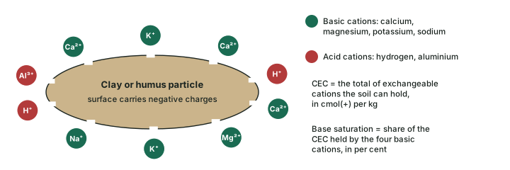
Base saturation is the share of the CEC held by "the four basic cations", calcium, magnesium, sodium and potassium, expressed as a percentage (Keys, 2022). A high base saturation marks a fertile, little-leached soil; a low one marks a soil whose bases have been washed out by rain and replaced by hydrogen and aluminium. Soil Taxonomy uses the number to separate orders (see soil classification): Alfisols have a base saturation of 35 per cent or more by sum of cations at a stated depth, Ultisols less than 35 per cent, and Mollisols need 50 per cent or more by ammonium acetate.
Worked example: Base saturation
An illustrative soil sample (not a real profile) has a CEC of 25 cmol(+)/kg. Its exchangeable calcium is 12, magnesium 4, potassium 1 and sodium 0.5 cmol(+)/kg. What is its base saturation?
- Add the four basic cations: 12 + 4 + 1 + 0.5 = 17.5 cmol(+)/kg.
- Divide by the CEC and multiply by 100: 17.5 / 25 x 100 = 70%.
- The rest of the exchange sites, about 30%, are held by acid cations (hydrogen and aluminium).
Answer: Base saturation = 70%. Because CEC depends on the pH at which it is measured, the same sample gives different percentages by the pH 7 and pH 8.2 methods; that is why Soil Taxonomy names the method in each threshold.
Life in the soil
NCERT calls soils "living systems. Like any other organism, they too develop and decay". Roots, fungi, bacteria, insects and burrowing animals do three jobs. They add organic matter, from fallen leaves to dead roots. They decompose it, releasing nutrients and leaving humus behind; in the hot, wet tropics, NCERT notes, humus "is removed fast by bacteria that thrives well in high temperature", which is one reason laterite soils are poor in organic matter. And they mix the soil: Soil Taxonomy even has a formative element (verm) for soils that are "wormy or mixed by animals". Organisms are one of the five state factors, the "o" in Jenny's equation (see the factors of soil formation, below).
Humification
Humification is the conversion of fresh plant and animal remains into humus. It is slow where the soil is cold, waterlogged or acid, so undecomposed litter piles up (the O horizon of the soil profile, and peat in bogs); it is fast where the soil is warm, moist and well aired. The Keys define the A horizon partly by this process: it is the surface mineral horizon marked by "an accumulation of humified organic matter closely mixed with the mineral fraction".
The factors of soil formation
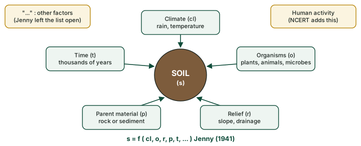
Why does the same granite weather into a deep red soil in Kerala but a thin grey one in the high Himalaya? The answer is that soil depends on several independent controls. NCERT lists them: "The major factors affecting the formation of soil are relief, parent material, climate, vegetation and other life-forms and time. Besides these, human activities also influence it to a large extent" (NCERT, India: Physical Environment, Class XI, 2020 edition, ch 6 (dropped from the current book)).
The idea that soil is a natural body shaped by such factors goes back to the Russian school of Vasily Dokuchaev, a geologist and soil scientist; Florinsky (2012, Eurasian Soil Science 45(4)) dates Dokuchaev's explicit statement of the idea that soil is a function of these factors, the basis of today's predictive soil mapping, to 1886. The idea was given its best-known mathematical form by Hans Jenny in Factors of Soil Formation: A System of Quantitative Pedology (1941):
s = f ( cl, o, r, p, t, ... )
Soil (s) is a function of climate (cl), organisms (o), relief (r), parent material (p) and time (t). The three dots matter: Jenny left the list open, so other factors, such as human activity, can be added. Florinsky also argues that Jenny adopted the equation from the Russian scientist Sergey Zakharov's textbook of 1927; that is a historian's reading, not a settled fact.
The factors of soil formation: NCERT and Jenny
| Factor | NCERT (2020) wording | Jenny's symbol (1941) | What it controls |
|---|---|---|---|
| Climate | climate | cl | water moving through the soil, temperature, speed of weathering and decay; the main control over large regions |
| Living things | vegetation and other life-forms | o | organic matter and humus, mixing, nutrient cycling |
| Relief | relief | r | drainage, erosion and deposition; thin soils on slopes, thick or waterlogged soils in hollows |
| Parent material | parent material | p | the minerals the soil starts with; it dominates young soils |
| Time | time | t | how far the processes have gone; soils evolve "over thousands of years" (NCERT) |
| Human activity | "human activities also influence it to a large extent" | not one of the five; covered by the open "..." | clearing, ploughing, irrigation, fertilisers, erosion and salinisation |
Source: NCERT, India: Physical Environment, Class XI, 2020 edition, ch 6 (dropped from the current book); Jenny (1941) as described by the University at Buffalo, Founders of Soil Concepts and Florinsky (2012).
Exam tip
Write Jenny's equation with the dots: s = f(cl, o, r, p, t, ...). A closed five-term equation misstates it. Attribute the idea to Dokuchaev's Russian school and the equation to Jenny (1941).
The factors work together, but over large regions climate usually dominates: the same parent rock gives different soils under different climates, and different rocks give similar soils under the same climate once enough time has passed. Where climate has not yet had its way, the other factors dominate: a young soil on fresh river silt still reflects its parent material, and a soil in a waterlogged hollow reflects relief and drainage more than climate. The soil classification part turns this into the old division of soils into zonal, intrazonal and azonal groups.
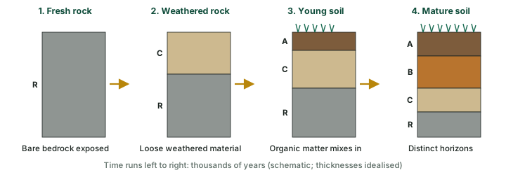
The diagram below shows the sequence NCERT describes. The C horizon, "the loose parent material", is "the first stage in the soil formation process and eventually forms the above two layers"; organic matter then works into the top to make an A horizon, and with time a B horizon develops between them.
The soil-forming processes
The factors set the conditions; the processes do the work. Most of them come down to one question: which way does water move through the soil, and what does it carry? In a wet climate water moves down and carries material out of the upper layers. In a dry climate it moves down only a little way, or is drawn back up by evaporation, and leaves material behind. Weathering, the breakdown of rock that supplies the mineral matter, belongs to geomorphology; the processes below act on what weathering provides.
Leaching, eluviation and illuviation
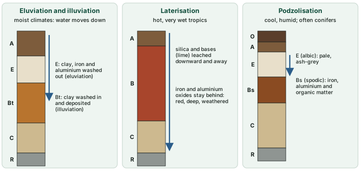
Leaching is the removal of soluble substances, such as bases and silica, by water percolating down through the soil, often right out of the profile. Eluviation ("washing out") is the movement of fine material, chiefly clay but also iron, aluminium and humus, out of an upper horizon. Illuviation ("washing in") is its deposition lower down. The horizon that loses material is the E horizon, whose main feature in the Keys' words is "the eluvial loss of silicate clay, iron, aluminum, or some combination of these, leaving a concentration of sand and silt particles". The horizon that gains clay is a Bt horizon; when the gain meets set limits it is an argillic horizon, "a subsurface horizon with a significantly higher percentage of phyllosilicate clay than the overlying soil material" that "shows evidence of clay illuviation" (Keys, 2022).
Don't confuse: Eluviation, illuviation and leaching
Eluviation = material moves out of a horizon (E horizon). Illuviation = material is deposited in a horizon (B horizon). Leaching = dissolved substances are carried away, often out of the soil altogether. Eluviation and illuviation are two ends of one movement.
Laterisation
NCERT explains laterite through this process. "Laterite has been derived from the Latin word 'Later' which means brick. The laterite soils develop in areas with high temperature and high rainfall. These are the result of intense leaching due to tropical rains. With rain, lime and silica are leached away, and soils rich in iron oxide and aluminium compound are left behind." Heat and moisture also speed the decay of organic matter, so humus stays low. The result is a deep, red, highly weathered soil, poor in bases. Laterisation is thus leaching taken to its extreme, with the unusual twist that silica, normally among the least mobile substances, is removed while iron and aluminium stay. India's laterite soils are described in soils of India.
Podzolisation
In cool, humid climates, usually under coniferous forest or heath, acid litter decays slowly and the water percolating from it is acidic and rich in organic compounds. The Keys define the process exactly: "Podzolization is the process of translocating iron and aluminum along with organic matter from the albic horizon into an underlying horizon, commonly a spodic or cambic horizon." The result is a striking profile: a pale, ash-grey E (albic) horizon above a dark reddish-brown B horizon where the iron, aluminium and organic matter accumulate, the spodic horizon of the Spodosols (see soil classification).
Don't confuse: Laterisation and podzolisation
Laterisation and podzolisation both need plenty of water moving down, but they move opposite things. Laterisation (hot, wet) removes silica and bases and leaves iron and aluminium oxides behind. Podzolisation (cool, humid, acid) moves iron and aluminium, with organic matter, out of the E horizon and down into the B.
Calcification
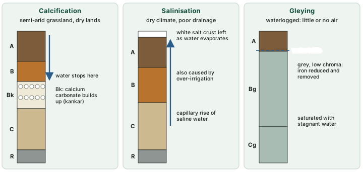
Where rainfall is too low to wash bases out of the profile, as in semi-arid grasslands and dry lands, water soaks in only part of the way. It dissolves calcium carbonate near the surface and redeposits it where the water stops, building a layer of lime. When the layer meets set limits, Soil Taxonomy calls it a calcic horizon, "an illuvial horizon in which secondary calcium carbonate or other carbonates have accumulated to a significant extent"; if the layer becomes cemented it is a petrocalcic horizon. NCERT describes the Indian form: in the arid soils of western Rajasthan, "lower horizons of the soil are occupied by 'kankar' layers because of the increasing calcium content downwards".
Salinisation and alkalisation
Salinisation is the build-up of soluble salts. In a dry climate, water in the soil rises by capillary action and evaporates at the surface, leaving its salts behind. NCERT names both the natural and the human cause: saline soils "have more salts, largely because of dry climate and poor drainage", and in areas of intensive irrigation, "especially in areas of green revolution", "excessive irrigation with dry climatic conditions promotes capillary action, which results in the deposition of salt on the top layer of the soil". Soil Taxonomy's salic horizon is "a horizon of accumulation of salts that are more soluble than gypsum in cold water".
Alkalisation is the build-up of sodium on the exchange sites rather than of salts in the soil water. Sodium makes clay disperse, so the clay is washed down easily: Soil Taxonomy's natric horizon is a clay-enriched subsoil horizon whose clay illuviation "has been accelerated by the dispersive properties of sodium". For salt-affected land NCERT notes that farmers in Punjab and Haryana "are advised to add gypsum to solve the problem of salinity in the soil". The soils of India and soil degradation parts return to these soils.
Gleying
Where a soil stays saturated for long periods, air cannot reach it and iron is chemically reduced. Reduced iron dissolves and moves, leaving grey, greenish or bluish colours, often with rusty mottles where air enters along roots and cracks. The Keys' suffix g, "strong gleying", means "either that iron has been reduced and removed during soil formation or that saturation with stagnant water has preserved it in a reduced state. Most of the affected layers have chroma of 2 or less". Gleying is found in marshes, river floodplains, paddy fields and the waterlogged parts of any landscape.
The soil-forming processes compared
| Process | Typical setting | Water movement | What moves or builds up | Horizon it marks | Indian example (NCERT) |
|---|---|---|---|---|---|
| Leaching | humid climates | down, through the profile | soluble bases and silica removed | whole profile poorer in bases | laterite areas (soils of India) |
| Eluviation / illuviation | humid climates | down | clay, iron, aluminium, humus out of upper layer and into lower | E (loses); Bt, argillic (gains) | - |
| Laterisation | hot, very wet tropics | strongly down | silica and lime removed; iron and aluminium oxides remain | deep red B | laterite soils of Karnataka, Kerala, Tamil Nadu |
| Podzolisation | cool, humid, acid litter | down | iron and aluminium with organic matter, E to B | E (albic) over Bs (spodic) | - |
| Calcification | semi-arid grassland and dry lands | down only part way | calcium carbonate builds up at depth | Bk, calcic | 'kankar' layers of western Rajasthan |
| Salinisation | dry climate, poor drainage, over-irrigation | up (capillary rise, evaporation) | soluble salts at or near the surface | salic horizon; z suffix | Punjab and Haryana irrigated areas |
| Alkalisation | as salinisation, sodium-rich | up, then down with dispersed clay | sodium on exchange sites; clay moves | natric | soils of India |
| Gleying | waterlogged ground | stagnant | iron reduced and removed; grey colours | g suffix (Bg, Cg) | - |
| Humification | everywhere, fastest when warm and moist | - | litter turned to humus | A (and O) | - |
Source: process definitions from USDA Soil Survey Staff, Keys to Soil Taxonomy, 13th ed. (2022); Indian examples from NCERT, India: Physical Environment, Class XI, 2020 edition, ch 6 (dropped from the current book). "Typical setting" is typical, not defining.
Summary
Soil is a natural body of minerals, organic matter, water and air that forms layers of its own or can carry plants. Its texture (sand, silt, clay), structure (peds and pores) and colour are its physical description; its pH, CEC and base saturation describe its chemistry and fertility. Climate, organisms, relief, parent material and time, with human activity, decide what kind of soil forms, and they act through a few processes, most of them set by the direction of water movement. The table of soil-forming processes above compares them; the soil profile part shows how each one leaves its mark on the soil profile.
Sources
Each table and data figure names its source beneath it. The main documents are collected here, with a date where the source carries one. Figures not listed under image credits were drawn for this page from the sources stated in their source lines.
Main sources
| Topic | Source |
|---|---|
| Textbook | NCERT, India: Physical Environment, Class XI, 2020 edition, ch 6 (dropped from the current book) |
| Definition of soil, texture, pH, CEC, base saturation and process definitions | USDA Soil Survey Staff, Keys to Soil Taxonomy, 13th ed. (2022) |
| Mollic colour limits | USDA Soil Survey Staff, Soil Taxonomy, 2nd ed. (1999) |
| Particle-size limits and texture classes | IUSS Working Group WRB, World Reference Base for Soil Resources, 4th ed. (2022, errata 2024); Soil Science Division Staff, 2017, Soil Survey Manual, USDA Handbook 18 |
| Pedology and edaphology | Canadian Soil Information Service glossary, Agriculture and Agri-Food Canada |
| Factors of soil formation | Hans Jenny, Factors of Soil Formation: A System of Quantitative Pedology (1941), as described by the University at Buffalo, Founders of Soil Concepts; Florinsky (2012), Eurasian Soil Science 45(4) |
Image credits
| Image | Credit and licence |
|---|---|
| Black peat soil on Hod Fen | Richard Humphrey, from Geograph Britain and Ireland. CC BY-SA 2.0, via Wikimedia Commons. File page |
| All other figures | Drawn for this page from the sources given in their source lines. |


