 BharatNotes
Part 8 of 9 of the Geomorphology and Landforms notes. The overview page has the quick revision, exam strategy and key terms for all nine parts.
Wind
In a hot desert the ground is bare, the air is dry and the wind can reach loose grains directly. NCERT calls wind "one of the two dominant agents in hot deserts"; the other, perhaps surprisingly, is running water, which arrives rarely but violently. This part explains how wind lifts, carries and throws sand, the landforms it carves (playas, deflation hollows, mushroom and table rocks, yardangs) and builds (the five dune types NCERT names, and loess), and how the work of wind and of sheet floods combine. It ends with India's own desert, the Thar.
Why deserts are the domain of wind
Wind blows everywhere, but it shapes the land only where it can reach loose material. The NPS lists the conditions that favour aeolian (wind) processes: "sparse or nonexistent vegetation cover, a supply of fine sediment (clay, silt, and sand), and strong winds." Hot deserts have all three. Wind also needs another agent to supply its sediment: aeolian processes "largely depend on other geologic agents, such as rivers, glaciers, and waves, to supply sediment" (NPS). That is why dunes also form behind beaches (see coastal landforms) and beside rivers.
NCERT explains why desert winds are so active. "The desert floors get heated up too much and too quickly because of being dry and barren." The hot floor heats the air directly above it, and the hot, lighter air rises with turbulence; any obstruction in its path "sets up eddies, whirlwinds, updrafts and downdrafts." Winds also move along the desert floor with great speed, and obstructions create more turbulence. There are also storm winds, which NCERT calls "very destructive."
Running water in the desert
Wind is not the only sculptor. NCERT stresses that "many features of deserts owe their formation to mass wasting and running water as sheet floods." Rain is scarce, but it falls torrentially in a short time. Desert rocks without vegetation decay fast under the drastic daily swing of temperature (see weathering), and torrential rain easily removes the weathered material. So weathered debris is moved by wind and by rain or sheet wash: "The wind moves fine materials and general mass erosion is accomplished mainly through sheet floods or sheet wash." Desert stream channels are "broad, smooth and indefinite" and flow only briefly after rain.
Key idea
In a desert, wind does the fine work (lifting dust, blasting rock, building dunes) and sheet floods do the heavy work (mass erosion of the landscape). Pediments, pediplains and inselbergs are made mainly by water; dunes, deflation hollows and mushroom rocks by wind.
How wind erodes and carries
NCERT names three processes: "Winds cause deflation, abrasion and impact."
- Deflation "includes lifting and removal of dust and smaller particles from the surface of rocks." It lowers the ground and leaves the coarser material behind.
- Abrasion: "In the transportation process sand and silt act as effective tools to abrade the land surface." Wind-borne grains scour and polish rock, much as sandpaper does.
- Impact "is simply sheer force of momentum which occurs when sand is blown into or against a rock surface. It is similar to sand-blasting operation."
Many textbooks add a fourth term, attrition: the grains themselves wear down and round off as they collide with one another in the wind. It is a standard term but not one NCERT uses; in an NCERT-based question, the three processes are deflation, abrasion and impact.
Rolling, saltation and suspension
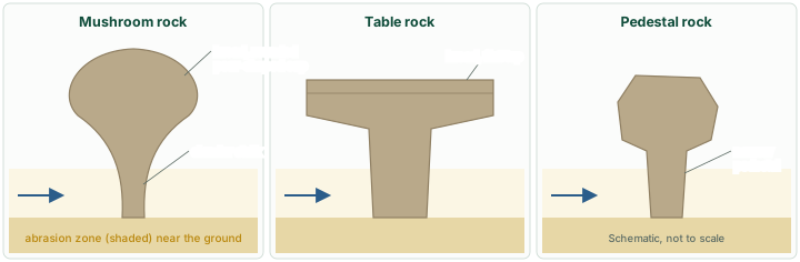
NCERT describes how the wind moves grains according to its speed: different sizes of grain "are moved along the floors by rolling or saltation and carried in suspension." The coarsest grains roll along the ground; sand grains move by saltation, a series of low bounces; and the finest dust and silt is carried in suspension, sometimes far beyond the desert. Because most saltating sand travels close to the ground, sand-blasting is strongest near the base of a rock, which explains the shape of the mushroom rocks described below.
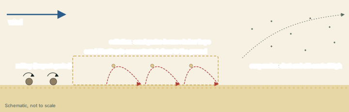
The same process sorts the sediment. "Wind is a good sorting agent," NCERT says: as the wind slows, grains settle according to their size and their critical velocities, so "in depositional landforms made by wind, good sorting of grains can be found." Dune sand is well sorted; loess is finer still (see below).
Don't confuse
NCERT: deflation, abrasion and impact. Some textbooks list deflation, abrasion and attrition. Abrasion is the wind's load wearing the rock; attrition is the load wearing itself; impact is the sheer force of sand thrown against a rock surface.
Erosional landforms
Pediments, pediplains and inselbergs: made by water
NCERT begins its list of desert erosional landforms with pediments, because "landscape evolution in deserts is primarily concerned with the formation and extension of pediments." Pediments are "gently inclined rocky floors close to the mountains at their foot with or without a thin cover of debris." They form through "a combination of lateral erosion by streams and sheet flooding", not by wind. As the mountain front retreats, the pediments extend backwards until only a remnant hill, an inselberg, is left, and the high relief is reduced to "low featureless plains called pediplains."
Isolated, steep-sided residual hills rising from flat desert plains are among the most striking desert landscapes, and they are often shown alongside wind-made features. NCERT, however, places inselbergs under pediplanation by running water (backwasting by sheet floods and streams), not under wind erosion. The part on landform development theories explains the process in full, with L. C. King's theory of pediplanation and a diagram of the pediment, pediplain and inselberg. Uluru in central Australia is often given as an example of such a residual; Parks Australia, which manages it, explains on its Geology page that "over the last 300 million years, the softer rocks eroded away, leaving the spectacular forms of Uluru and Kata Tjuta behind," and that "Uluru is a type of rock called arkose."
Playas and alkali flats
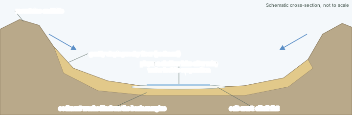
"Plains are by far the most prominent landforms in the deserts," NCERT says. In a basin ringed by mountains and hills, drainage runs towards the centre, and sediment washed in from the margins slowly builds a nearly level plain there. After enough rain the plain is covered by a shallow water body. "Such types of shallow lakes are called as playas where water is retained only for short duration due to evaporation and quite often the playas contain good deposition of salts." A playa plain covered with salts is an alkali flat.
Deflation hollows and caves
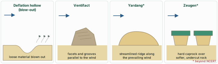
Where the wind blows persistently in one direction, it removes the weathered mantle or bare soil and "may create shallow depressions called deflation hollows" (NCERT). The NPS describes a deflation hollow, also called a blowout, as "created when loose surface material is scooped out by the wind, leaving a hollow." Deflation also makes numerous small pits or cavities on rock surfaces. On rock faces, impact and abrasion by wind-borne sand first create shallow depressions called blow outs, and "some of the blow outs become deeper and wider fit to be called caves."
Mushroom, table and pedestal rocks
Rock outcrops that are easily attacked by deflation and abrasion wear away quickly, "leaving some remnants of resistant rocks polished beautifully in the shape of mushroom with a slender stalk and a broad and rounded pear shaped cap above" (NCERT). Sometimes the top surface is broad like a table top, making a table rock, and quite often the remnants stand out like pedestals. The narrow base is where the sand-blasting works hardest, near the ground, where saltating sand is concentrated; the cap, higher up, is struck far less. NCERT's India: Physical Environment names mushroom rocks among the well-pronounced desert features of the Thar (see the Thar below).
Ventifacts, yardangs, zeugen and desert pavement
Four further wind-made forms are standard in textbooks though not in NCERT:
- Ventifacts are, in the NPS definition, "rocks that are abraded, pitted, etched, grooved, or polished by wind-driven sand or ice crystals." They are "most typically found in arid environments," and ancient ventifacts are useful to geologists as "excellent paleo-wind indicators as the grooves and striations cut into the rock are parallel with the wind direction."
- Yardangs are streamlined ridges of compact (cohesive) sediment or soft rock, carved by wind erosion and lying in the direction of the prevailing wind; the NPS describes them as "streamlined ridges of compact sand lying in the direction of the prevailing wind, formed by wind erosion of surrounding material."
- Zeugen (beyond NCERT) are table-like blocks where a hard cap of rock protects softer rock beneath; abrasion undercuts the softer layer, and the blocks stand separated by furrows.
- Desert pavement (reg) (beyond NCERT): a surface of interlocking pebbles, gravel or boulders, left behind once deflation has blown the finer particles away.
Erosional landforms of deserts
| Landform | Main agent | What it looks like | In NCERT? |
|---|---|---|---|
| Pediment | Streams (lateral erosion) and sheet floods | Gently inclined rocky floor at the foot of mountains | Yes |
| Pediplain | Sheet floods and streams, by parallel retreat of slopes | Low, featureless plain | Yes |
| Inselberg | Sheet floods and streams (pediplanation) | Remnant hill rising from the plain | Yes (under pediplanation) |
| Playa / alkali flat | Running water and evaporation | Shallow, short-lived lake on a level basin floor; salt-covered when dry | Yes |
| Deflation hollow | Wind (deflation) | Shallow depression where loose material has been blown out | Yes |
| Blow-out and cave | Wind (impact and abrasion) | Shallow depression in a rock face, deepened into a cave | Yes |
| Mushroom, table and pedestal rocks | Wind (deflation and abrasion) | Resistant remnants on narrowed bases | Yes |
| Ventifact | Wind (abrasion) | Pebble or boulder with facets and grooves | No (NPS) |
| Yardang | Wind (abrasion) | Streamlined ridge aligned with the prevailing wind | No (NPS) |
| Zeugen | Wind (abrasion) | Blocks of hard caprock on undercut softer rock | No (standard term) |
Source: NCERT, Fundamentals of Physical Geography, Class XI, chapter 6 "Landforms and their Evolution" (Reprint 2026-27); US National Park Service, "Aeolian landforms" (updated 1 Dec 2022).
Depositional landforms
How a dune works
"Dry hot deserts are good places for sand dune formation," NCERT says, and it adds that "obstacles to initiate dune formation are equally important": a bush, a rock or a change of slope slows the wind enough for sand to start piling up. Wherever there is a good source of sand and a constant wind direction, depositional features can develop anywhere in arid regions. The NPS notes that "dunes seldom exist by themselves, but as vast fields of many dunes."
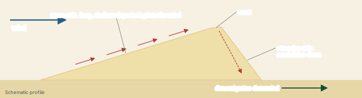
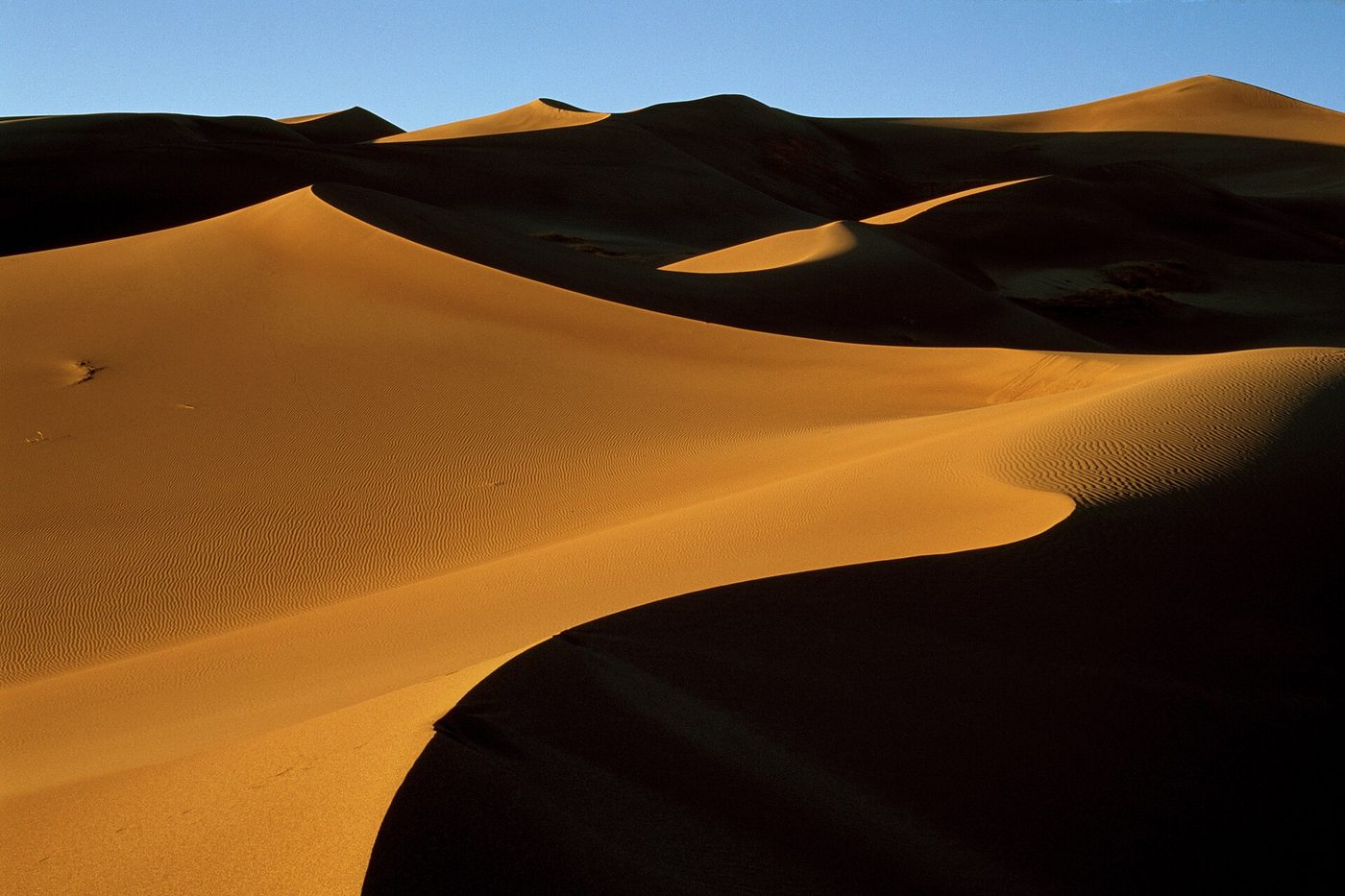
Most dunes share the same profile. In the NPS description, a dune has "a long shallow angle (stoss) facing into the wind, a peak (crest), and a steep lee side." Sand is pushed up the gentle stoss side by saltation, drops over the crest into the sheltered air beyond, and slides down the steep lee side. Repeated grain by grain, this moves the whole dune downwind, which is why, in NCERT's words, "most of the dunes in the deserts shift."
The five dune types in NCERT
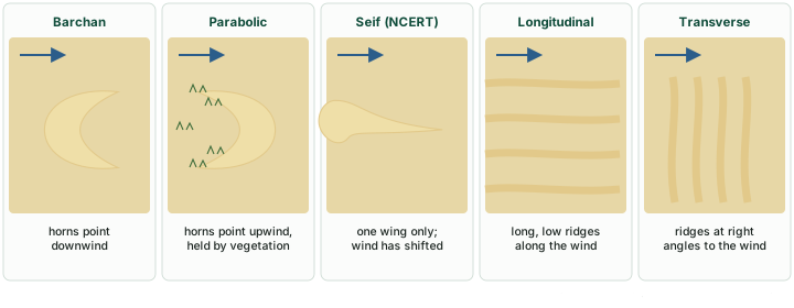
The shape a dune takes depends on three things: how steady the wind is, how much sand there is, and whether vegetation holds some of it. NCERT's own diagram (figure 6.14 of its chapter) shows five types, with arrows for the wind:
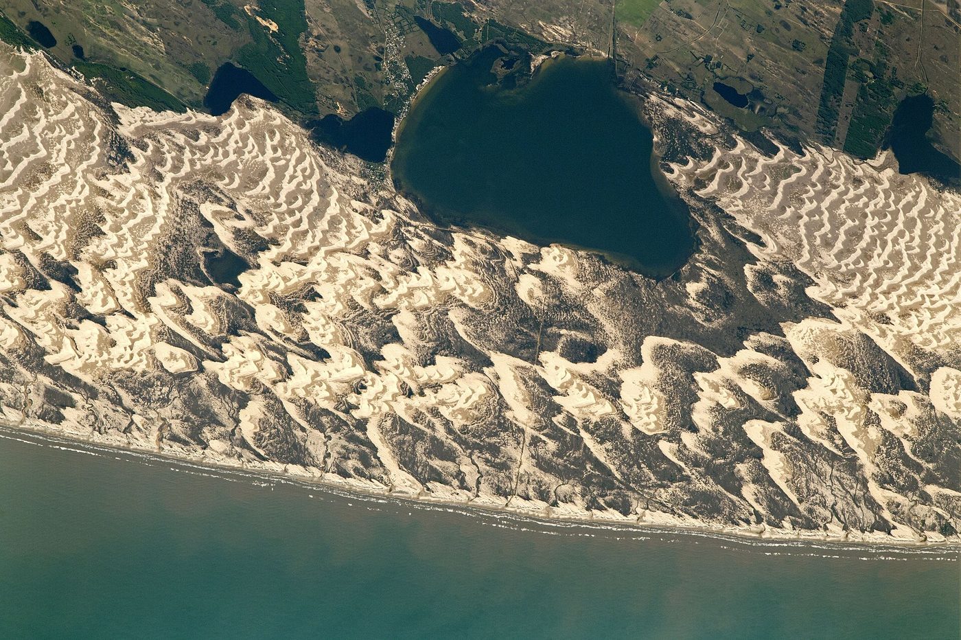
- Barchans: "Crescent shaped dunes called barchans with the points or wings directed away from wind direction i.e., downwind, form where the wind direction is constant and moderate and where the original surface over which sand is moving is almost uniform." The usual textbook explanation is that the thin horns move faster than the thicker centre, so they run ahead downwind.
- Parabolic dunes "form when sandy surfaces are partially covered with vegetation. That means parabolic dunes are reversed barchans with wind direction being the same." In the usual textbook explanation, plants anchor the arms while the bare centre is blown forward, so the horns point upwind.
- Seif: "Seif is similar to barchan with a small difference. Seif has only one wing or point. This happens when there is shift in wind conditions. The lone wings of seifs can grow very long and high."
- Longitudinal dunes "form when supply of sand is poor and wind direction is constant. They appear as long ridges of considerable length but low in height."
- Transverse dunes "are aligned perpendicular to wind direction. These dunes form when the wind direction is constant and the source of sand is an elongated feature at right angles to the wind direction. They may be very long and low in height."
When sand is plentiful, NCERT notes, "the regular shaped dunes coalesce and lose their individual characteristics," and while most desert dunes shift, "a few of them will get stabilised especially near human habitations."
Don't confuse: seif vs longitudinal
Seif and longitudinal dunes: NCERT and research differ. NCERT treats them as two different forms: a seif is a one-winged barchan produced when the wind shifts, while a longitudinal dune is a long, low ridge formed where sand is poor and the wind constant. Much of the research literature treats seif and linear (longitudinal) dunes as the same family of long ridges running roughly parallel to the wind. For objective questions set from NCERT, follow NCERT's distinction.
Dune types compared
| Dune | Shape (plan view) | Orientation to the wind | Conditions (NCERT) |
|---|---|---|---|
| Barchan | Crescent | Horns point downwind | Constant, moderate wind; almost uniform surface |
| Parabolic | Reversed crescent (U or V) | Horns point upwind | Sandy surface partly covered with vegetation |
| Seif | Crescent with only one wing, which can grow very long and high | Lone wing extends downwind | Shift in wind conditions |
| Longitudinal | Long, low ridges | Parallel to the wind | Poor sand supply; constant wind |
| Transverse | Long, low ridges | Perpendicular to the wind | Constant wind; sand source elongated at right angles to the wind |
Source: NCERT, Fundamentals of Physical Geography, Class XI, chapter 6 "Landforms and their Evolution" (Reprint 2026-27).
Exam tip
Two pairs are easy to reverse. Barchan horns point downwind, parabolic horns upwind (vegetation holds them back). Longitudinal dunes lie along the wind, transverse dunes across it.
Loess
The finest material, silt carried in suspension, can travel far beyond the desert before settling as loess, a deposit of wind-blown silt (beyond NCERT). The NPS describes loess deposits as "wind-blown silt deposits common along the Mississippi River Valley" in the United States. A major loess landscape is China's Loess Plateau. Where its dust came from is still argued: the Gobi Desert has long been seen as the main source, but a 2019 study found that the Gobi "may not be the main source of loess with very low contributions" to the plateau under today's winds (Wang and others, "Contributions of modern Gobi Desert to the Badain Jaran Desert and the Chinese Loess Plateau", Scientific Reports 9: 985, 30 Jan 2019). Like other wind deposits, loess is well sorted.
The Thar: India's desert
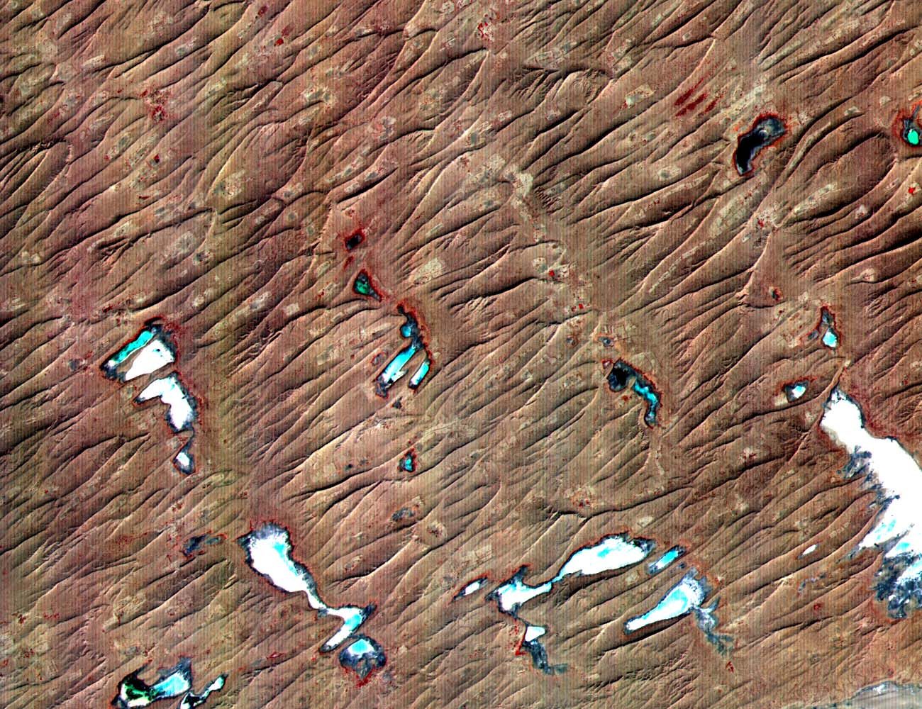
NCERT's India: Physical Environment places the Great Indian Desert to the north-west of the Aravali hills. It is "a land of undulating topography dotted with longitudinal dunes and barchans." The region receives "low rainfall below 150 mm per year", so it has an arid climate with low vegetation cover, and for these features it is also called Marusthali.
The rock beneath the sand tells a longer story. NCERT notes that during the Mesozoic era this region is believed to have been under the sea, corroborated by the wood fossils park at Aakal and the marine deposits around Brahmsar, near Jaisalmer, with the wood fossils estimated to be about 180 million years old. The underlying rock structure is an extension of the Peninsular plateau, which NCERT elsewhere describes as visible as far as Jaisalmer, where it "has been covered by the longitudinal sand ridges and crescent-shaped sand dunes called barchans." Because of the extreme aridity, the surface features have been carved by physical weathering and wind action. NCERT names the well-pronounced landforms: mushroom rocks, shifting dunes and oases (mostly in the southern part).
By its slope, the desert falls into two parts: the northern part slopes towards Sindh and the southern part towards the Rann of Kachchh. Most rivers are ephemeral; the Luni flows in the southern part. Some streams "disappear after flowing for some distance and present a typical case of inland drainage by joining a lake or playa." These lakes and playas "have brackish water which is the main source of obtaining salt" (NCERT). The playas described above are therefore not only a textbook form: in the Thar they are a resource.
Remember
NCERT on the Thar: north-west of the Aravalis; rainfall below 150 mm a year; longitudinal dunes and barchans; mushroom rocks, shifting dunes and oases; Mesozoic sea (wood fossils at Aakal, marine deposits at Brahmsar, near Jaisalmer); north slopes to Sindh, south to the Rann of Kachchh; inland drainage into lakes and playas, whose brackish water is the main source of salt.
Summary
- Wind shapes land where vegetation is sparse, fine sediment is available and winds are strong; hot deserts fit all three. Running water, as sheet floods, does most of the mass erosion even there.
- NCERT's wind processes are deflation, abrasion and impact; attrition is an additional textbook term. Grains move by rolling, saltation and suspension, and wind sorts them well.
- Erosional forms: playas and alkali flats, deflation hollows, blow-outs and caves, mushroom, table and pedestal rocks (NCERT); ventifacts, yardangs, zeugen and desert pavement (beyond NCERT). Pediments, pediplains and inselbergs are made mainly by running water (see landform development theories).
- Dunes have a gentle stoss side, a crest and a steep lee side, and migrate downwind. NCERT's five types: barchan, parabolic, seif, longitudinal and transverse. NCERT separates seif and longitudinal dunes; much research treats them as one family.
- Loess is wind-blown silt; China's Loess Plateau is a major example.
- The Thar (Marusthali) has longitudinal dunes and barchans, mushroom rocks, shifting dunes, oases, and playas whose brackish water yields salt.
Wind and water in the desert: who makes what
| Made mainly by wind | Made mainly by running water (sheet floods, streams) |
|---|---|
| Deflation hollows, blow-outs and caves | Pediments and pediplains |
| Mushroom, table and pedestal rocks | Inselbergs (remnant hills) |
| Ventifacts, yardangs, zeugen, desert pavement | Playas and alkali flats (with evaporation) |
| Sand dunes: barchan, parabolic, seif, longitudinal, transverse | Broad, shallow, short-lived stream channels |
| Loess (wind-blown silt) | General mass erosion of the desert surface |
Source: NCERT, Fundamentals of Physical Geography, Class XI, chapter 6 "Landforms and their Evolution" (Reprint 2026-27); US National Park Service, "Aeolian landforms" (updated 1 Dec 2022).
Sources
Each table and figure names its source beneath it. The main documents are collected here, with a date where the source carries one. Figures not listed under image credits were drawn for this page from the sources stated in their source lines.
Main sources
| Topic | Source |
|---|---|
| Textbooks | NCERT, Fundamentals of Physical Geography, Class XI, chapter 6 "Landforms and their Evolution" (Reprint 2026-27); NCERT, India: Physical Environment, Class XI |
| Wind processes, erosional forms and dunes | US National Park Service, "Aeolian landforms" (updated 1 Dec 2022) |
| Loess Plateau | Wang and others, "Contributions of modern Gobi Desert to the Badain Jaran Desert and the Chinese Loess Plateau", Scientific Reports 9: 985 (30 Jan 2019) |
| Uluru | Parks Australia, Uluṟu-Kata Tjuṯa National Park, "Geology" |
Image credits
| Image | Credit and licence |
|---|---|
| ISS-52 Barchan Dunes and Lagoons, Southern Brazil | NASA Astronaut photograph from ISS, 9 July 2017. Public domain. File page |
| Dunes at sunset along the southern edge of the dune field in Great Sand Dunes National Park | NPS / Debra Miller, 27 July 2008. Public domain. File page |
| Thar Desert (ASTER) | NASA/METI/AIST/Japan Space Systems, and U.S./Japan ASTER Science Team, 2001. Public domain. File page |
| All other figures | Drawn for this page from the sources given in their source lines. |