 BharatNotes
Part 9 of 9 of the Geomorphology and Landforms notes. The overview page has the quick revision, exam strategy and key terms for all nine parts.
Theories of Landform Development
The parts on fluvial, karst, glacial, coastal and aeolian landforms described landforms one agent at a time. This part asks a bigger question: how does a whole landscape change through time? Three models answer it, and examiners ask for all three and for the contrasts between them. William Morris Davis described a "geographical cycle" in which uplifted land is worn down through youth, maturity and old age to a peneplain. Walther Penck argued that uplift and erosion work together, and that the form of a slope records the rate at which rivers cut down. L. C. King, working from African landscapes, built a cycle of pediplanation in which retreating scarps leave pediments, pediplains and inselbergs. NCERT describes the stages of a river valley and the formation of pediments without naming any of the three, so this part connects NCERT's text to the theories behind it.
Davis's geographical cycle
The American geographer William Morris Davis set out his "geographical cycle" in a paper of that name in The Geographical Journal in 1899. The INFLIBNET e-PG Pathshala module on models of slope development summarises the core of it: "Davis argued that all physical landforms can be analysed in terms of the three variables- structure, process and stage."
- Structure: the rock itself, its disposition, hardness and porosity, and its folds and faults.
- Process: the agents of erosion at work, such as running water.
- Stage: time, meaning how far the cycle has advanced.
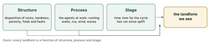
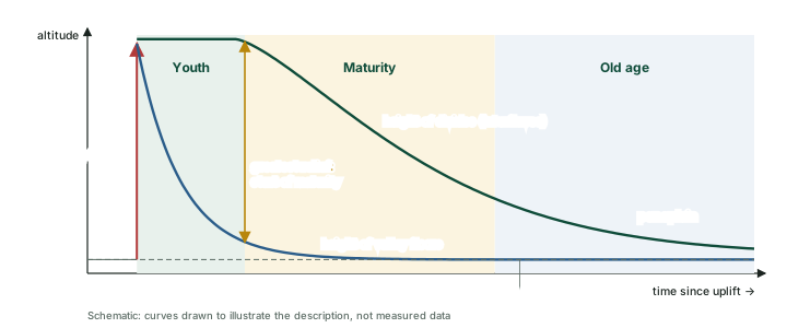
Davis started from a simple assumption. He "visualised the initial landform as a mass of land uplifted from the sea. The process of upliftment was faster and the denudation processes acted upon it from the time it almost became a stable mass" (e-PG). Uplift, in other words, comes first and quickly; erosion then works on land that stays still. Davis compared the landscape to a living being that passes through youth, maturity and old age, and the stages are relative, not fixed lengths of time: a cycle runs longer in resistant rock. His "normal" cycle was the one he saw as typical of the humid temperate lands, worked by running water.
Youth
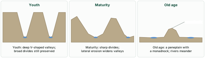
After uplift, rivers begin cutting down rapidly. The e-PG summary of Davis describes "rapid downward erosion resulting in formation of deep valley bounded by very steep slopes", a V-shaped valley. "The divide summits are preserved in this stage": between the valleys, the broad surfaces of the uplifted land are still largely intact. Headward erosion lengthens the valleys, and the youthful stage "is marked with ... waterfalls, rapids and gorges."
Maturity
In maturity, valley deepening slows and lateral erosion becomes the dominant process, widening the valleys. "In this phase begins the lowering of interfluves summit thereby reducing the relief" (e-PG). Relief, the difference in height between the divides and the valley floors, grows through youth, as the valleys deepen while "the divide summits are preserved", and starts to fall once maturity begins to lower the divides. The divides become sharp ridges as valleys widen on both sides, and the rivers approach a graded condition.
Old age
Old age is the slowest and longest stage. Rivers meander across broad, flat valley floors, the divides are worn down, and at the end "the land surface appears as a flat featureless plain known as ‘peneplain’" (e-PG). A few hills of more resistant rock survive above it: "Davis called these isolated hills as ‘Monadnocks’". NCERT describes the same end-state for running water without naming Davis: a landscape at or slightly above sea level, reduced to a peneplain, with monadnocks standing out (see fluvial landforms).
Davis's stages and NCERT's river stages
| Stage | Davis (as summarised in the e-PG module) | NCERT, running water |
|---|---|---|
| Youth | Rapid down-cutting; deep V-shaped valleys with very steep slopes; divide summits preserved; headward erosion; waterfalls, rapids and gorges | Few streams with poor integration, flowing over original slopes; "shallow V-shaped valleys"; broad, flat divides with marshes, swamps and lakes |
| Maturity | Valley deepening declines; lateral erosion predominates; interfluves lowered, relief starts to fall | Plenty of streams with good integration; valleys "still V-shaped but deep"; divides turn sharp |
| Old age | Slowest and longest stage; a flat, featureless peneplain with monadnocks | Few smaller tributaries with gentle gradients; streams meander freely over vast floodplains; broad, flat divides; most of the landscape at or slightly above sea level; a peneplain with monadnocks |
Source: INFLIBNET e-PG Pathshala (Geography), K. Moin, "Models of slope development: Davis, Penck, King, Wood and Strahler"; NCERT, Fundamentals of Physical Geography, Class XI, chapter 6 "Landforms and their Evolution" (Reprint 2026-27).
Don't confuse: deep V and shallow V
Davis's youth (as summarised in the e-PG module) has deep V-shaped valleys with steep sides. NCERT's description of a river in youth (see fluvial landforms) has "shallow V-shaped valleys", few streams with poor integration and broad, flat stream divides with marshes, swamps and lakes. The two are describing different things (Davis a whole uplifted landscape being dissected, NCERT the early stage of a river valley), but the words differ, so quote NCERT for NCERT-based questions and Davis when the question is about Davis.
Rejuvenation and other cycles
A renewed uplift, called rejuvenation, starts down-cutting again before the cycle is complete; incised meanders and river terraces (see fluvial landforms) are the standard signs of it. Davis did not confine himself to the humid "normal" cycle. In 1905 he published "The Geographical Cycle in an Arid Climate" in the Journal of Geology, extending the idea to deserts, and in 1932, in "Piedmont Benchlands and Primarrumpfe", he set his view of slope retreat against Penck's (Tuan).
Davis on slopes
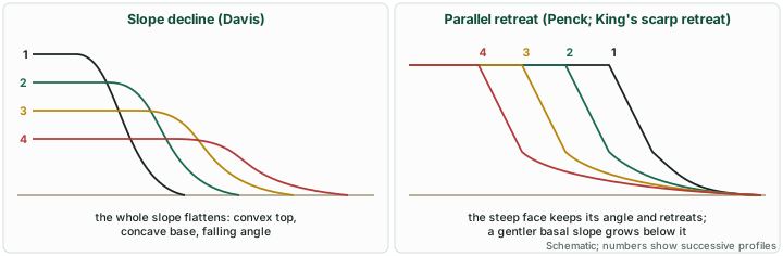
Davis's cycle implies that slopes wear down by declining: as the cycle advances, the e-PG summary notes, landforms "will not remain stable for a long period of time rather their height and slope will decline with the passage of time." In his 1932 paper he described valley sides that retreat while losing steepness, with a convex upper part (which he attributed to soil creep) and a concave base. This is the idea that Penck's model challenged (see below).
Criticisms of Davis
The e-PG module records the main objections raised by later geomorphologists:
- Uplift and stability. The cycle assumes rapid uplift followed by a long still-stand. Penck, for one, argued that uplift and erosion go on together.
- The peneplain. Critics "regarded peneplain as theoretical landform because they considered that for Davis’ cycle to run its full course it requires the landform should remain stable for a very long time. This possibility was very rare." They also pointed out that as erosion removes load, isostatic adjustment pushes the land up again, so "the attainment of peneplain stage is questioned as it contradicts the view of isostatic adjustment."
- Simplicity. "Most geomorphologist also believe that Davis’ idea of sequential change of landform is too simplistic," since real landform evolution is far more complex.
- Climate. The cycle was built on a humid-temperate "normal" model, with other climates treated as departures from it. It is wrong, though, to say that Davis ignored climate: he himself added an arid cycle in 1905.
Even so, the e-PG module concludes: "Although Davis cycle has faced a lot of criticism, it still holds its place" in the study of landform evolution: its terms (youth, maturity, old age, peneplain, monadnock) remain the vocabulary of the subject, and NCERT's river-stage description is built on them.
Exam tip
When asked to "critically examine" Davis, give his three variables and three stages, then the criticisms in order (uplift and stability, the peneplain and isostasy, simplicity, the humid-temperate base) and end with his lasting contribution. Avoid the claim that he "ignored climate": his 1905 arid cycle shows otherwise.
Penck's morphological analysis
Walther Penck was an Austrian-born German geomorphologist, born in Vienna on 30 August 1888 and died in Stuttgart on 29 September 1923; he was the son of Albrecht Penck (AEIOU Austria-Lexikon). His main work, Die morphologische Analyse (Morphological Analysis), was published posthumously by his father in 1924. The SAGE Encyclopedia of Geography (edited by Barney Warf, 2010; entry "Penck, Walther (1888–1923)", pp. 2143-2146) notes: "Written in highly convoluted German, it received very little attention in Germany."
Uplift and erosion together
Penck was dissatisfied with Davis's short burst of uplift followed by a long still-stand. In his model, as the e-PG module puts it, the "landscape would simultaneously be eroded with the process of its upliftment. The rates of denudation would vary." What shapes the landscape is the balance between the rate of uplift and the rate of erosion, and that balance changes through time.
Slope form records the rate of down-cutting
Penck's key idea is that the form of a valley side records how fast the river at its foot is cutting down. In the e-PG summary: "Convex slopes develop where the rivers are having an accelerated rate of downward erosion," "Rectilinear slopes are formed where rivers are eroding at a constant rate," and "Concave slopes occur above the rivers which erode at a decelerating rate." Textbooks name the three phases waxing development (accelerating down-cutting, convex slopes), uniform development (a constant rate, straight slopes) and waning development (decelerating down-cutting, concave slopes); Penck's German term for the last is absteigende Entwicklung.
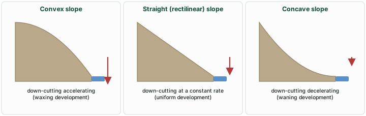
Penck's phases of development
| Phase (textbook name) | Rate of river down-cutting | Slope form |
|---|---|---|
| Waxing development | Accelerating | Convex |
| Uniform development | Constant | Straight (rectilinear) |
| Waning development (absteigende Entwicklung) | Decelerating | Concave; ends in a low plain, the Endrumpf |
Source: INFLIBNET e-PG Pathshala (Geography), K. Moin, "Models of slope development: Davis, Penck, King, Wood and Strahler"; Tuan, "The misleading antithesis of Penckian and Davisian concepts of slope retreat in waning development", Proceedings of the Indiana Academy of Science.
Parallel retreat and the Endrumpf
Penck also differed from Davis on how a slope wears back. In his model a steep slope unit retreats parallel to itself, keeping its angle, and leaves below it a basal slope of lower gradient; the flattening therefore proceeds "from below upwards" (e-PG). Tuan, examining Penck's analysis, puts it precisely: "during waning development (absteigende Entwicklung), only the cliff or rock wall (Steilwand or Felswand) of the valley slope retreats parallel to itself. The valley slope as a whole becomes concave and its gradient declines." The end product is a low, featureless plain that Penck called the Endrumpf. It is comparable to Davis's peneplain as an end-form, but its origin is different: it is reached by slope replacement under changing rates of uplift, not by the gradual decline of every slope on stable land.
A debated contrast
The neat contrast "Davis = slope decline, Penck = parallel retreat" is the one textbooks and examiners use, and it is a fair summary of the two models. Tuan, writing in the Proceedings of the Indiana Academy of Science, argued that the antithesis is partly misleading: in Penck's waning development only the steep cliff retreats parallel to itself, while the valley slope as a whole becomes concave and its gradient declines, which is close to Davis. The sharp contrast owes much to a simple diagram in Davis's own 1932 paper. Use the contrast, but know that it is a simplification.
Penck's central claim, that slope form depends on the rate of river erosion, links the shape of slopes to the rate of uplift; the e-PG module adds that structure, climate and rock type also shape slopes.
King's pediplanation
L. C. King set out his model in "Canons of Landscape Evolution", published in the Bulletin of the Geological Society of America in 1953. According to the e-PG module, King based his work on his observation of African landscapes, and he held that subtropical and semi-humid climates, rather than the humid temperate climates of Davis's base, should be regarded as the "normal" case. He later extended the concept beyond Africa to other, non-arid climates.
The four hillslope elements
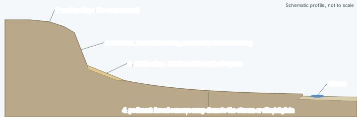
King accepted the four elements of a hillslope described by Wood in 1942, and held that they are found "in hillslopes all over the world in all climatic environments" (King, 1957, as quoted in the e-PG module). From the top down:
- Waxing slope: "the convex crest of a hill or scarp".
- Free face: "the outcrop of bare bedrock", the most active element in backwearing.
- Debris slope: detritus from the free face resting at its angle of repose.
- Pediment: a "broad concave ramp extending from the base" of the slope down to the bank or alluvial plain of the adjacent stream.
Scarp retreat and the pediment
In King's landscapes, scarps "maintain steep slopes of 15 to 30 degree" (e-PG): "There is no reduction in their steepness when they are wasted back by weathering or rainwash." This is parallel scarp retreat. As the scarp moves back, the pediment at its foot grows. Pediments are, in King's words as summarised in the e-PG module, "normally covered with detritus but pediments themselves are essentially cut rock surfaces." In the same summary: "The pediment is the fundamental landform to which epigene landscapes tends to be reduced."
NCERT describes the same process in its account of desert landforms, without naming King. Once pediments form "with a steep wash slope followed by cliff or free face above it, the steep wash slope and free face retreat backwards. This method of erosion is termed as parallel retreat of slopes through backwasting. So, through parallel retreat of slopes, the pediments extend backwards at the expense of mountain front, and gradually, the mountain gets reduced leaving an inselberg which is a remnant of the mountain. That's how the high relief in desert areas is reduced to low featureless plains called pediplains." NCERT also names the agents: lateral erosion by streams and sheet flooding (see aeolian landforms).
The cycle of pediplanation
King arranged these processes into a cycle (e-PG):
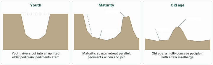
- Youth: the cycle "begins with upliftment of an earlier formed pediplain." Rivers cut down rapidly. Near the end of youth the down-cutting slows and pediments emerge in the valley bottoms, widening as the scarps retreat; by late youth most interfluves have become inselbergs, many of them rounded like domes.
- Maturity: scarps go on retreating, inselbergs become fewer and the pediments widen and coalesce.
- Old age: only a few residual hills remain on a broad pediplain. King described the pediplain as "multi-concave upward" (1953), because it is made of many joined concave pediments.
Key idea
An inselberg is not a hill that wind has carved. In NCERT it is "a remnant of the mountain" left as pediments extend backwards by parallel retreat of slopes through backwasting, driven by streams and sheet floods. King's theory is the larger version of the same idea.
King's model raises the question already asked of Davis: how far can a model drawn from one region and one climate be applied everywhere? Davis generalised from humid temperate lands, King from African landscapes; both extended their models to other climates. Penck's emphasis on the rate of uplift, and King's parallel retreat, together moved the study of slopes away from the single, stage-by-stage sequence that Davis proposed.
Davis, Penck and King compared
Three models of landform development
| Question | Davis | Penck | King |
|---|---|---|---|
| Main work | "The Geographical Cycle" (1899); arid cycle (1905) | Die morphologische Analyse (1924, posthumous) | "Canons of Landscape Evolution" (1953) |
| Base landscape or climate | Humid temperate, the "normal" cycle | Landscapes still being uplifted while they erode | Subtropical and semi-humid Africa as "normal" |
| Uplift | Rapid, then a long still-stand | Simultaneous with erosion; rates vary | Uplift of an earlier pediplain starts a new cycle |
| How slopes change | Slope decline: slopes lose steepness | Parallel retreat of the steep slope unit; form set by the rate of down-cutting | Parallel scarp retreat at 15 to 30 degrees |
| Key slope forms | Convex top (soil creep), concave base | Convex (waxing), straight (uniform), concave (waning) | Waxing slope, free face, debris slope, pediment |
| End product | Peneplain with monadnocks | Endrumpf | Multi-concave pediplain with inselbergs |
| Stages | Youth, maturity, old age | Waxing, uniform and waning development | Youth, maturity, old age of pediplanation |
| Points of debate | Long still-stand assumed; peneplain theoretical (isostasy); too simple; humid-temperate base | Written in convoluted German and published posthumously; little attention in Germany (SAGE) | How far a model drawn from African landscapes applies to other climates |
Source: INFLIBNET e-PG Pathshala (Geography), K. Moin, "Models of slope development: Davis, Penck, King, Wood and Strahler"; Tuan, "The misleading antithesis of Penckian and Davisian concepts of slope retreat in waning development", Proceedings of the Indiana Academy of Science; Davis, W. M. (1899) "The Geographical Cycle", The Geographical Journal 14: 481 (doi 10.2307/1774538); Davis, W. M. (1905) "The Geographical Cycle in an Arid Climate", Journal of Geology 13: 381-407 (doi 10.1086/621241); King, L. C. (1953) "Canons of Landscape Evolution", GSA Bulletin 64: 721; AEIOU Austria-Lexikon, "Penck, Walther".
Remember
End products: Davis, peneplain (residuals: monadnocks); Penck, Endrumpf; King, pediplain (residuals: inselbergs). Slopes: Davis, decline; Penck and King, parallel retreat.
Summary
- Davis (1899) analysed landforms by structure, process and stage. After rapid uplift, a landscape passes through youth (deep V-shaped valleys, divides preserved), maturity (greatest relief at its start, then lateral erosion and lowering of interfluves) and old age (a peneplain with monadnocks).
- NCERT's river stages follow the same sequence but describe youthful valleys as "shallow V-shaped"; NCERT does not name Davis, Penck or King.
- Davis was criticised for assuming a long still-stand, for an end-form that isostasy makes unlikely, for simplicity and for a humid-temperate base; he did, however, add an arid cycle in 1905.
- Penck (1888-1923; Die morphologische Analyse, 1924) held that uplift and erosion act together and that slope form records the rate of down-cutting: convex when accelerating, straight when constant, concave when decelerating. Steep slope units retreat parallel to themselves; the end-form is the Endrumpf.
- King (1953) adopted Wood's four hillslope elements, described parallel scarp retreat and built a cycle of pediplanation ending in a multi-concave pediplain with inselbergs. NCERT's account of pediments describes the same process.
Sources
Each table and figure names its source beneath it. The main documents are collected here, with a date where the source carries one. All figures on this page were drawn for it from the sources stated in their source lines.
Main sources
Image credits
| Image | Credit and licence |
|---|---|
| All figures | Drawn for this page from the sources given in their source lines. |