 BharatNotes
Part 7 of 9 of the Geomorphology and Landforms notes. The overview page has the quick revision, exam strategy and key terms for all nine parts.
Waves and Currents
Coasts change faster than almost any other landscape. NCERT calls coastal processes "the most dynamic and hence most destructive": a beach can lose its sand in one season and regain it in the next, and a single storm or tsunami can do more in a few hours than ordinary waves do in years. This part explains how breaking waves and currents work on the shore, why a high rocky coast and a low sedimentary coast develop different landforms, and how each erosional and depositional form takes its shape. It ends with India, whose west coast is a high rocky retreating coast and whose east coast is a low sedimentary one.
Cross-paper relevance
- GS1 (Geography, primary): waves, currents and coastal landforms; high rocky and low sedimentary coasts; India's west and east coasts
- GS3 (Disaster management): off-shore bars, barriers, beaches, dunes and mangroves as the first natural defence against storm and tsunami waves
- GS3 (Environment): Chilika lagoon as a Ramsar site and its time on the Montreux Record
How waves and currents work on a coast
NCERT is direct: "Most of the changes along the coasts are accomplished by waves." When a wave breaks, "the water is thrown with great force onto the shore, and simultaneously, there is a great churning of sediments on the sea bottom." That constant impact is what wears back cliffs and moves sand. The force of the breaking waves rises and falls with the wave environment, and storm waves and tsunami waves "can cause far-reaching changes in a short period of time" compared with normal breaking waves. (The forces that generate waves and currents belong to oceanography and are covered in the notes on the movements of ocean water.)
Besides the waves themselves, NCERT names two controls on the landforms of a coast: (i) the configuration of the land and the sea floor, and (ii) whether the coast is advancing seaward (emerging) or retreating landward (submerging). To explain how coastal landforms evolve, NCERT assumes the sea level stays constant and compares two kinds of coast, which are described below.
Wave refraction: why headlands wear back and bays fill with sand
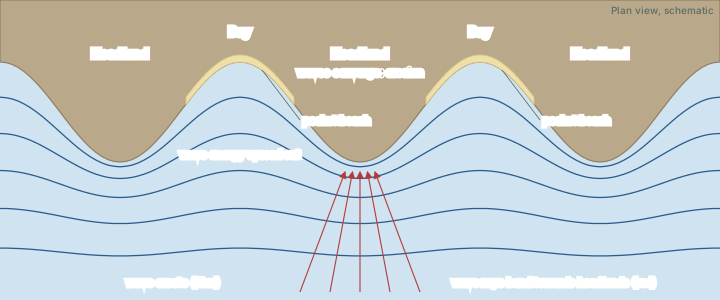
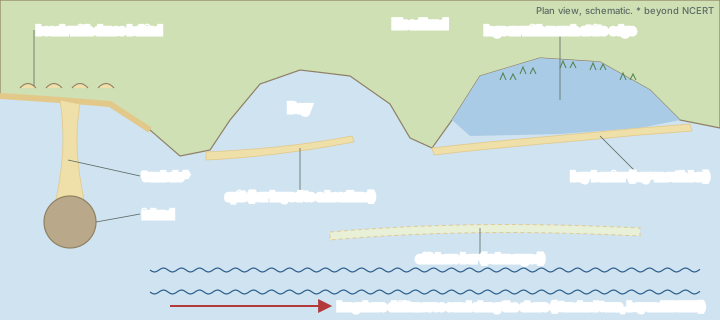
Waves approaching an irregular coast do not hit it evenly. They slow down where the water is shallow, so the crests bend round to follow the shape of the shore. The US National Park Service (NPS) describes the result: "Waves are refracted around the headlands, increasing erosion at seaward positions," while "the protected embayments, where wave action is subdued between headlands, are often transformed into sandy pocket beaches." Wave energy is focused on the headlands and spread thinly round the bays, so an irregular coast is slowly straightened: the headlands are cut back and the bays are filled. NCERT makes the same point in its own words: "Waves gradually minimise the irregularities along the shore."
Currents that carry the sand
Waves loosen and lift sediment; currents carry it. NCERT credits "longshore currents and waves" with depositing eroded material as beaches along the shore and as bars in the nearshore zone. Where waves reach the shore at an angle, they push sand along the beach in the direction the current flows, a movement that textbooks call longshore drift (a standard term that NCERT does not use). The NPS describes spits as made of "sediments that have been suspended by waves and transported by currents." Whenever the current slows, for example where the coast turns into a bay or where an island shelters the water behind it, the sand drops out and builds a landform.
Key idea
Erosion happens where wave energy is concentrated (headlands, exposed cliffs); deposition happens where it is spread out or the current slows (bays, the lee of islands, gently sloping shores). Almost every coastal landform described here follows from that one idea.
Two kinds of coast
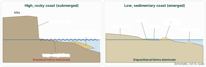
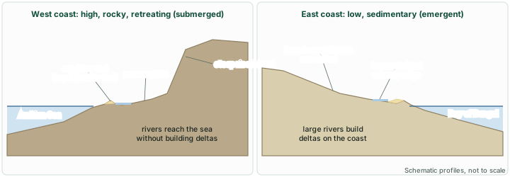
NCERT explains coastal evolution with two contrasting coasts: high, rocky coasts, which it calls submerged coasts, and low, smooth and gently sloping sedimentary coasts, which it calls emerged coasts.
High rocky coasts (submerged)
Along a high rocky coast, NCERT says, "the rivers appear to have been drowned with highly irregular coastline." The coastline is highly indented, with the sea extending into the land where glacial valleys (fjords, see glacial landforms) reach the coast, and the hill sides drop off sharply into the water. At first the shore has no depositional landforms at all: erosion features dominate. Waves break with great force against the land and shape the hill sides into cliffs. With constant pounding the cliffs recede, leaving a wave-cut platform in front of them.
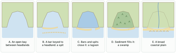
The rock that falls from the cliffs is broken into smaller pieces and rolled to roundness, and it is deposited offshore. After a long period of cliff retreat, when the coastline has become somewhat smoother, this offshore deposit grows into a wave-built terrace in front of the wave-cut terrace. Erosion also gives longshore currents and waves a good supply of material, which they lay down as beaches along the shore and as bars, "long ridges of sand and/ or shingle parallel to the coast", in the nearshore zone. From here the sequence runs into deposition: bars that show above water are barrier bars; a barrier bar keyed to the headland of a bay is a spit; bars and spits that block the mouth of a bay create a lagoon; and the lagoon slowly fills with sediment from the land to become a coastal plain (see the depositional landforms below).
Rock type affects how the cliffs wear back. The NPS notes that "massive rocks, such as granite, will normally erode in a uniform manner, whereas layered sedimentary rocks may erode in a step-wise fashion," and that rocky, erosion-dominated coasts "are typically located on active margins with narrow continental shelves."
Low sedimentary coasts (emerged)
Along a low sedimentary coast, the rivers "appear to extend their length by building coastal plains and deltas." The coastline is smooth, broken only occasionally by lagoons and tidal creeks; the land slopes gently into the water, and marshes and swamps may abound. Depositional features dominate. When waves break over a gently sloping sedimentary coast, the bottom sediments are churned and move readily, building bars, barrier bars, spits and lagoons. In time, NCERT says, "Lagoons would eventually turn into a swamp which would subsequently turn into a coastal plain." Large rivers that bring plenty of sediment build deltas along such coasts (deltas are covered in fluvial landforms).
These depositional forms survive only as long as sediment keeps arriving: "The maintenance of these depositional features depends upon the steady supply of materials." Storm and tsunami waves, however, "cause drastic changes irrespective of supply of sediments."
High rocky coasts and low sedimentary coasts
| Feature | High rocky coast | Low sedimentary coast |
|---|---|---|
| NCERT name | Submerged coast | Emerged coast |
| Coastline | Highly irregular and indented; drowned river valleys; fjords where glacial valleys reach the sea | Smooth, with occasional lagoons and tidal creeks |
| Slope into the sea | Hill sides drop sharply into the water | Land slopes gently into the water |
| Dominant forms | Erosional: cliffs, wave-cut platforms and terraces, caves, stacks | Depositional: beaches, bars, barrier bars, spits, lagoons, marshes, deltas |
| Rivers | Appear drowned | Extend their length by building coastal plains and deltas |
| Later stages | Debris builds a wave-built terrace; bars, spits and lagoons appear once the coast is smoother | Lagoons turn into swamps and then coastal plains, if sediment supply continues |
| India | West coast (NCERT) | East coast (NCERT) |
Source: NCERT, Fundamentals of Physical Geography, Class XI, chapter 6 "Landforms and their Evolution" (Reprint 2026-27).
Exam tip
NCERT pairs the words in a way that is easy to reverse. The high rocky coast is the submerged coast (the land has gone down relative to the sea, drowning the river valleys); the low sedimentary coast is the emerged coast. India's west coast is the first kind, the east coast the second.
Erosional landforms
Cliffs, wave-cut platforms and terraces
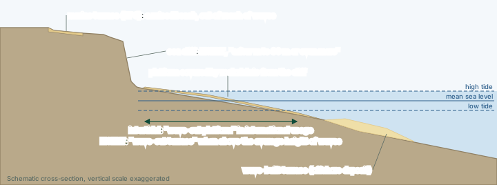
"Wave-cut cliffs and terraces are two forms usually found where erosion is the dominant shore process," NCERT says. "Almost all sea cliffs are steep and may range from a few m to 30 m or even more." A sea cliff forms as waves undercut the land at its base until the rock above loses its support and falls. The NPS uses the term wave-cut scarp for the same kind of feature: "a steep bank created by wave erosion."
At the foot of the cliff there may be a flat or gently sloping platform, covered by rock debris that has come from the cliff behind. The name of this platform is where NCERT and international usage part company, so learn both:
- NCERT: "Such platforms occurring at elevations above the average height of waves is called a wave-cut terrace." NCERT uses wave-cut platform for the surface the receding cliff leaves in front of it, and wave-cut terrace for such a platform lying above the average height of the waves.
- International usage: the wave-cut platform (or shore platform) is the gently sloping rock surface at the base of a retreating cliff, lying in the intertidal zone between high and low tide, where waves still work on it.
- A platform raised right out of reach of the waves is what the NPS calls a marine terrace: "a raised beach or 'perched coastline' that has been raised out of the reach of wave activity."
The debris carried off the platform does not vanish. It is deposited offshore and, as NCERT describes, builds a wave-built terrace in front of the wave-cut terrace.
Don't confuse: platforms and terraces
Wave-cut terrace (NCERT): a platform at the foot of a cliff lying above the average height of the waves. Wave-cut platform (international usage): the intertidal rock platform at the foot of a cliff. Wave-built terrace: an offshore deposit of eroded debris in front of the wave-cut terrace, so it is depositional, not erosional. Marine terrace (NPS): a raised beach lifted out of reach of the waves. For an NCERT-based objective question, use NCERT's definitions.
Sea caves, arches, stacks and stumps
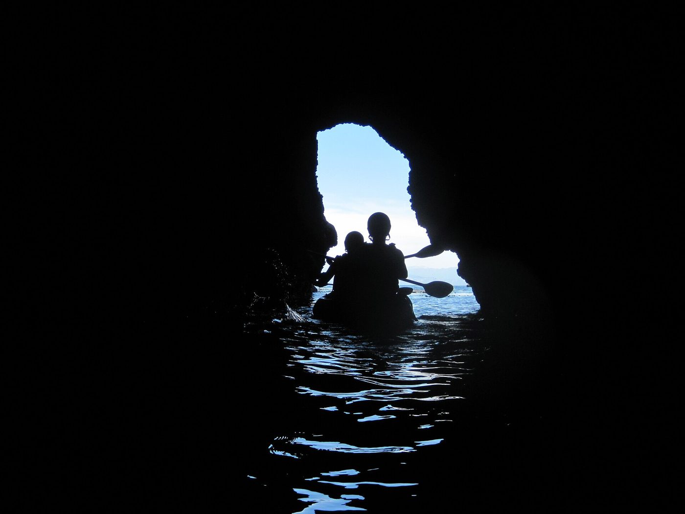
NCERT describes how the cliff itself is hollowed out: "The lashing of waves against the base of the cliff and the rock debris that gets smashed against the cliff along with lashing waves create hollows and these hollows get widened and deepened to form sea caves." The debris is the tool: waves armed with rock fragments erode far faster than water alone. The NPS adds that sea caves "may form in less resistant, easily erodible bedrock located on promontories," which is why caves are most common on headlands, where refraction focuses the waves.
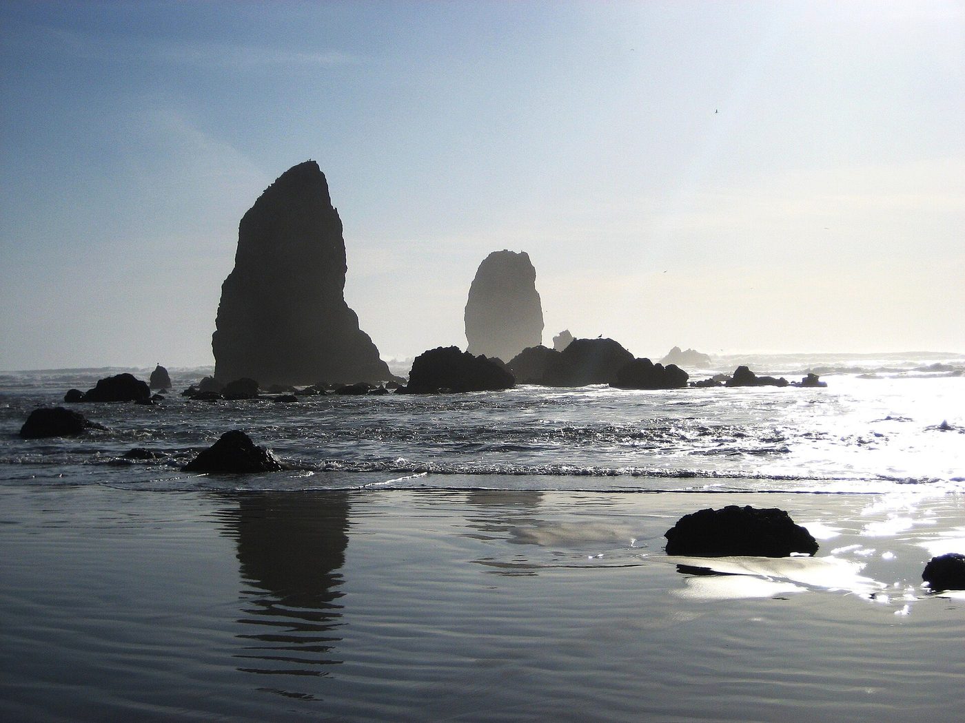
When erosion cuts right through a narrow headland, the cave becomes a sea arch, an opening through which the sea passes. NCERT does not use the word arch; it moves straight from caves to stacks: "The roofs of caves collapse and the sea cliffs recede further inland. Retreat of the cliff may leave some remnants of rock standing isolated as small islands just off the shore. Such resistant masses of rock, originally parts of a cliff or hill are called sea stacks." The NPS fills in the arch stage: "With prolonged erosion, sea arches may collapse to form sea stacks," steep pillars of rock a short distance from the mainland, and "both sea stacks and sea arches are impermanent features." A stack worn down further, until only a low rock just above or below the water remains, is called a stump in many textbooks (a term beyond NCERT). The Old Man of Hoy, on the island of Hoy in Orkney, Scotland, is a well-known sea stack.
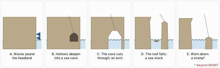
NCERT stresses that none of this lasts: "Like all other features, sea stacks are also temporary and eventually coastal hills and cliffs will disappear because of wave erosion giving rise to narrow coastal plains." Deposits from the land behind may then bury that plain under alluvium, or shingle and sand may cover it to form a wide beach. Erosion on a rocky coast therefore ends by handing the shore over to deposition.
Remember
The erosional sequence on a headland: cave → arch → stack → stump. NCERT names caves and stacks; the arch is in the NPS description; the stump is beyond NCERT. All of them are temporary.
Depositional landforms
Beaches
"Beaches are characteristic of shorelines that are dominated by deposition, but may occur as patches along even the rugged shores," NCERT says, which is why the pocket beaches described above sit between rocky headlands. Most beach sediment "comes from land carried by the streams and rivers or from wave erosion." The NPS defines a beach by what is happening on it: "the location along a shoreline where the sediment is in motion, being moved by waves, tides, and currents."
Because the sediment keeps moving, beaches are temporary. In NCERT's words, "The sandy beach which appears so permanent may be reduced to a very narrow strip of coarse pebbles in some other season." Most beaches are made of sand-sized material; shingle beaches are made of small pebbles and even cobbles.
Coastal dunes
"Just behind the beach, the sands lifted and winnowed from over the beach surfaces will be deposited as sand dunes." NCERT adds that "sand dunes forming long ridges parallel to the coastline are very common along low sedimentary coasts." The NPS calls the first ridge, next to the shore, the foredunes ("the primary dune ridge"), with secondary dune fields further inland. These are dunes built by wind (see aeolian landforms), but their sand comes from the beach.
Bars, barriers and spits
NCERT defines the family carefully, and its definitions are the ones to learn:
- Off-shore bar: "A ridge of sand and shingle formed in the sea in the off-shore zone lying approximately parallel to the coast." Bars are submerged features.
- Barrier bar: "An off-shore bar which is exposed due to further addition of sand." Off-shore bars and barriers "commonly form across the mouth of a river or at the entrance of a bay."
- Spit: "Sometimes such barrier bars get keyed up to one end of the bay when they are called spits." Spits "may also develop attached to headlands/hills." The NPS describes a barrier spit as "the landform resulting from the deposition of sediments in long ridges extending out from coasts" and gives Cape Cod in Massachusetts, which "terminates at Provincetown spit", as a famous example. NCERT's own example is a spit on the Godavari delta in India (NCERT's figure 6.13; see India's coasts below).
A spit grows in the direction the sand is moving. Sand carried along the shore keeps travelling when the coast turns into a bay, the current slows in the deeper, calmer water of the bay mouth, and the sand is laid down as a ridge that extends from the headland across the bay.
Lagoons, swamps and coastal plains
Bars and spits do not stop growing. "The barriers, bars and spits at the mouth of the bay gradually extend leaving only a small opening of the bay into the sea and the bay will eventually develop into a lagoon." The NPS gives the enclosing spit a name of its own: once it "can completely cut off a bay from the ocean, forming a lagoon," it "is then called a bay barrier or a bay-mouth bar."
The lagoon is not the end. It "get[s] filled up gradually by sediment coming from the land or from the beach itself (aided by wind) and a broad and wide coastal plain may develop replacing a lagoon" (NCERT). Along the way, as the water shallows and plants take hold, the lagoon becomes a swamp. This is NCERT's own sequence, and an examiner may describe any stage of it.
Tombolos and barrier islands
NCERT does not describe tombolos, but they complete the set of sand ridges. In the NPS account, a tombolo forms when sediment joins an offshore landform, such as an island or a sea stack, to the mainland. "The tombolo forms because the island or sea stack refracts the waves, causing a zone of slow moving water behind the island. Whenever water carrying sediment slows down, sediment is deposited." It is the same rule as before: slow water drops its load.
Barrier islands (a term beyond NCERT) are long, narrow islands of sand lying parallel to the coast, with a lagoon or marsh between them and the mainland. The NPS calls them "one of the most common and distinguishable features of the Atlantic coast" of the United States, and notes that they "protect the mainland from storm events and wave action." NCERT's barrier bar is the same idea at a smaller scale.
Why it matters: bars, beaches and mangroves as a buffer
NCERT's "Do you know" box explains why these forms matter for people: "the coastal off-shore bars offer the first buffer or defence against storm or tsunami by absorbing most of their destructive force. Then come the barriers, beaches, beach dunes and mangroves, if any, to absorb the destructive force of storm and tsunami waves." Anything that "disturbs the 'sediment budget' and the mangroves along the coast" lets these forms erode away, "leaving human habitations to bear first strike of storm and tsunami waves."
Ridges of sand: how to tell them apart
| Landform | What it is | What it is attached to | Source of the definition |
|---|---|---|---|
| Off-shore bar | Submerged ridge of sand and shingle, roughly parallel to the coast | Nothing: lies in the off-shore zone | NCERT |
| Barrier bar | An off-shore bar built up until it is exposed above water | Often across a river mouth or bay entrance | NCERT |
| Spit | Barrier bar keyed up to one end of a bay | One end on the land (a headland or hill); the other end free | NCERT; NPS |
| Bay barrier (bay-mouth bar) | A spit grown long enough to cut a bay off from the sea | Both sides of the bay | NPS |
| Lagoon | The water body enclosed behind bars and spits | Behind the barrier | NCERT |
| Tombolo | Sediment ridge connecting an island or sea stack to the mainland | Mainland and island | NPS (beyond NCERT) |
| Barrier island | Long, narrow sand island parallel to the coast, separated by a lagoon or marsh | Neither end attached | Standard term (beyond NCERT); NPS describes them |
Source: NCERT, Fundamentals of Physical Geography, Class XI, chapter 6 "Landforms and their Evolution" (Reprint 2026-27); US National Park Service, "Sandy coast landforms" (updated 11 Dec 2019).
India's coasts
NCERT applies the two-coast model to India in four sentences worth knowing by heart: "The west coast of our country is a high rocky retreating coast. Erosional forms dominate in the west coast. The east coast of India is a low sedimentary coast. Depositional forms dominate in the east coast."
The western coastal plains
NCERT's India: Physical Environment describes the western coastal plains as "an example of submerged coastal plain", and notes the belief that the city of Dwaraka, once on the mainland, lies submerged under the water. The plains are a narrow belt, narrow in the middle and broader towards the north and south. Because the coast is submerged, it offers natural conditions for ports and harbours: NCERT lists Kandla, Mazagaon, JLN port Navha Sheva, Marmagao, Mangalore and Cochin. From north to south, NCERT divides the plains into the Kachchh and Kathiawar coast in Gujarat, the Konkan coast in Maharashtra, the Goan coast, and the Malabar coast in Karnataka and Kerala. The rivers flowing through this coastal plain do not form any delta.
The Malabar coast has a distinctive landform: the kayals, or backwaters. These are shallow, lagoon-like water bodies behind the coast, "used for fishing, inland navigation and also due to its special attraction for tourists," and every year the Nehru Trophy Vallamkali (boat race) is held in Punnamada Kayal in Kerala (NCERT). Vembanad in Kerala is a well-known example of these backwater systems. Kayals show that a mainly erosional coast can still carry depositional forms: sand bars and spits enclosing quiet water behind them.
The eastern coastal plains
The eastern coastal plains, NCERT says, are broader and are "an example of an emergent coast." Here the rivers do build deltas: the Mahanadi, the Godavari, the Krishna and the Kaveri have well-developed deltas on this coast. Because the coast is emergent, it has fewer ports and harbours than the west coast. Lagoons, spits and bars are typical, as the low sedimentary model predicts, and NCERT's example of a spit (figure 6.13 of its chapter) is a satellite picture of "a part of Godavari river delta showing a spit".
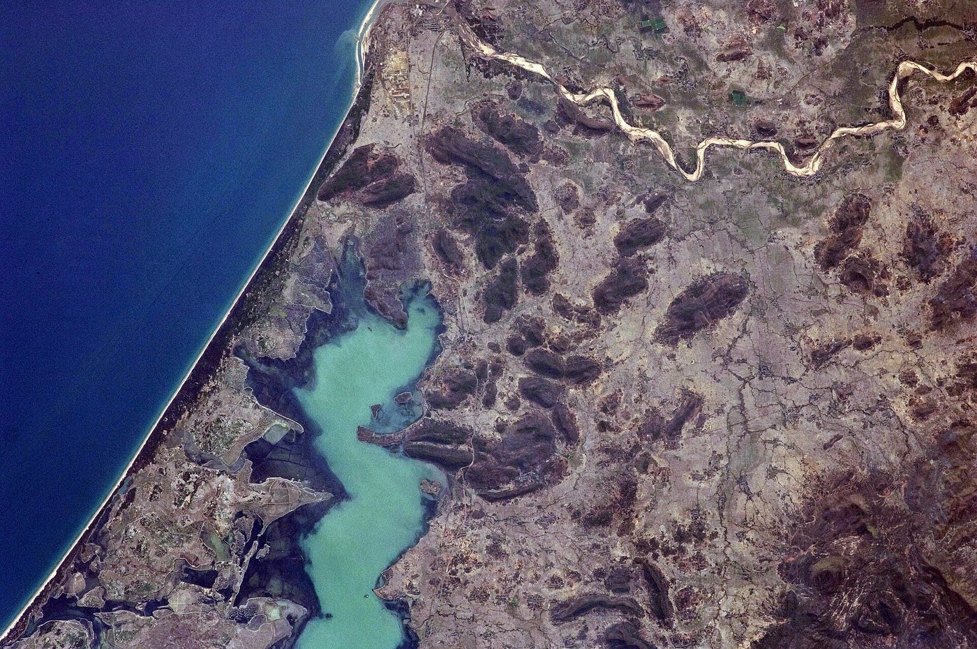
Chilika: a lagoon behind a sandy ridge
Chilika in Odisha is the textbook Indian lagoon. The Chilika Development Authority describes it as "Asia's largest brackish water lagoon". The Ramsar Convention listed it as a Wetland of International Importance on 1 October 1981 (Ramsar site 229), and its Ramsar record describes exactly the landform this part has built up: a "brackish lake separated from the Bay of Bengal by a long sandy ridge and subject to sea water exchange, resulting in extreme seasonal fluctuations in salinity in different sections of the lake." The same record notes that Chilika was added to the Montreux Record on 16 June 1993 and removed from it on 11 November 2002. NCERT's India: Physical Environment also lists Chilika Lake (Odisha) among India's Ramsar sites protected as water-fowl habitats.
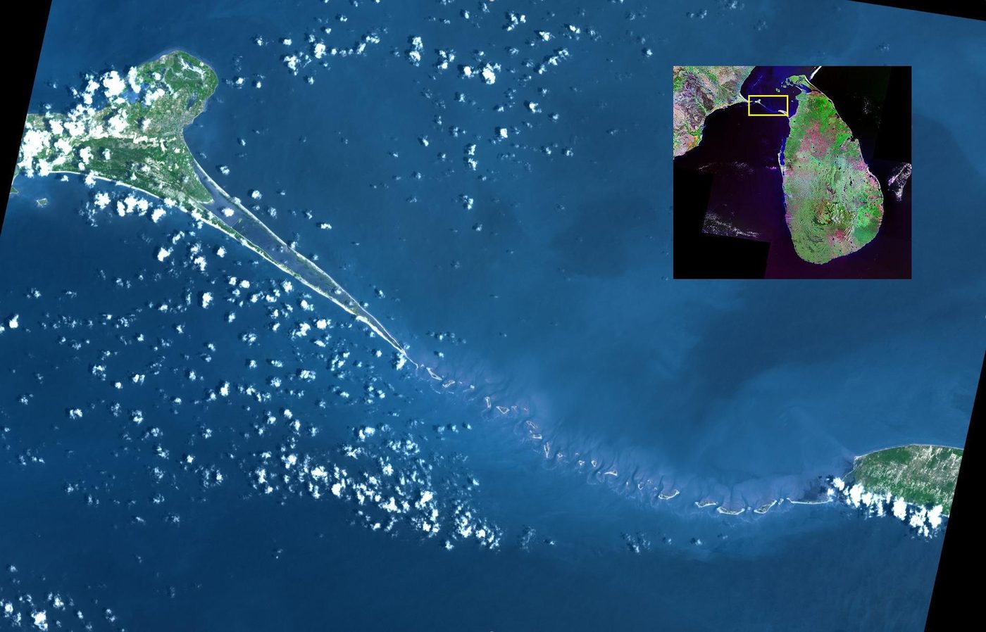
Between India and Sri Lanka: Adam's Bridge
Between the south-east coast of India and Sri Lanka lies Adam's Bridge. NASA's Jet Propulsion Laboratory describes it as "a 48 km long chain of limestone shoals" that formerly formed a land bridge between India and Sri Lanka, and adds that "the geologic origin of the bridge is still controversial." It is a good reminder to treat any single explanation of its origin as a hypothesis, not settled fact.
Exam tip
A one-line answer to "why does the east coast have deltas and the west coast does not?" in NCERT's terms: the east coast is a low, emergent sedimentary coast where large rivers bring plenty of sediment and build deltas, while the west coast is a high, submerged rocky coast with a narrow plain whose rivers form no delta. (Fluvial landforms adds that the Narmada and Tapi flow through rift valleys and end in estuaries.)
India's two coasts compared
| Feature | West coast | East coast |
|---|---|---|
| Type (NCERT) | High rocky retreating coast; submerged | Low sedimentary coast; emergent |
| Dominant landforms | Erosional | Depositional |
| Width of the plain | Narrow belt; narrow in the middle, broader in the north and south | Broader |
| Deltas | Rivers form no delta | Mahanadi, Godavari, Krishna and Kaveri deltas |
| Ports and harbours | Natural conditions for ports: Kandla, Mazagaon, JLN port Navha Sheva, Marmagao, Mangalore, Cochin | Fewer ports and harbours |
| Divisions (north to south) | Kachchh and Kathiawar (Gujarat), Konkan (Maharashtra), Goan coast, Malabar (Karnataka, Kerala) | - |
| Characteristic water bodies | Kayals (backwaters) of the Malabar coast, e.g. Punnamada Kayal | Lagoons, e.g. Chilika (Odisha) |
| NCERT spit example | - | Godavari delta (NCERT figure 6.13) |
Source: NCERT, Fundamentals of Physical Geography, Class XI, chapter 6 "Landforms and their Evolution" (Reprint 2026-27); NCERT, India: Physical Environment, Class XI, chapter 2 "Structure and Physiography" (Reprint 2026-27); Ramsar Sites Information Service, Chilika Lake (site 229).
Summary
- Waves do most of the work on a coast; storm and tsunami waves can change it far faster than ordinary waves. Currents carry the sediment that waves loosen, and wave refraction focuses erosion on headlands and spreads it across bays.
- The landforms of a coast depend on the configuration of the land and sea floor, and on whether the coast is emerging or submerging. NCERT contrasts high rocky (submerged) coasts, where erosion dominates, with low sedimentary (emerged) coasts, where deposition dominates.
- Erosional forms: sea cliffs (a few m to 30 m or more), wave-cut platforms and terraces (NCERT's terrace lies above the average height of waves; international usage puts the platform in the intertidal zone), sea caves, arches, stacks and stumps. All are temporary.
- Depositional forms: beaches (temporary, sand or shingle), dunes parallel to the coast, off-shore bars, barrier bars, spits, bay barriers, lagoons, tombolos and barrier islands. A bay passes through spit, lagoon and swamp to become a coastal plain.
- Off-shore bars, barriers, beaches, dunes and mangroves are a coast's natural defence; disturbing the sediment budget removes it.
- India's west coast is high, rocky and retreating, with a narrow plain, natural harbours, kayals and no deltas; the east coast is low and sedimentary, broad, with large deltas, lagoons such as Chilika and the Godavari spit.
Coastal landforms by process
| Landform | Erosional or depositional | How it forms | Where to expect it |
|---|---|---|---|
| Sea cliff | Erosional | Waves undercut the base of the land; the rock above falls | High rocky coasts; headlands |
| Wave-cut platform / terrace | Erosional | Left in front of a receding cliff | Foot of cliffs |
| Sea cave | Erosional | Waves and smashed debris hollow out the cliff base | Weaker rock on headlands |
| Sea arch | Erosional | A cave cut right through a headland | Narrow headlands |
| Sea stack / stump | Erosional | An arch roof collapses or the cliff retreats, leaving a pillar; the pillar is worn low | Just off a retreating coast |
| Wave-built terrace | Depositional | Eroded debris deposited offshore in front of the wave-cut terrace | Seaward of a platform |
| Beach | Depositional | Sediment from rivers and wave erosion, kept moving by waves, tides and currents | Depositional shores; pockets in bays |
| Off-shore bar / barrier bar | Depositional | Sand and shingle ridge built in the off-shore zone; exposed as more sand is added | River mouths, bay entrances |
| Spit | Depositional | Barrier bar keyed to one end of a bay or a headland | Where the coast turns into a bay |
| Lagoon | Depositional | Bay enclosed by bars and spits; fills to swamp and coastal plain | Low sedimentary coasts; Chilika |
| Tombolo | Depositional | Sediment dropped in the slow water behind an island or stack | Island close to the shore |
Source: NCERT, Fundamentals of Physical Geography, Class XI, chapter 6 "Landforms and their Evolution" (Reprint 2026-27); US National Park Service, "Rocky coast landforms" (updated 20 Mar 2019); US National Park Service, "Sandy coast landforms" (updated 11 Dec 2019).
Sources
Each table and figure names its source beneath it. The main documents are collected here, with a date where the source carries one. Figures not listed under image credits were drawn for this page from the sources stated in their source lines.
Main sources
| Topic | Source |
|---|---|
| Textbooks | NCERT, Fundamentals of Physical Geography, Class XI, chapter 6 "Landforms and their Evolution" (Reprint 2026-27); NCERT, India: Physical Environment, Class XI, chapter 2 "Structure and Physiography" (Reprint 2026-27) |
| Wave refraction, rocky coasts, caves, arches and stacks | US National Park Service, "Rocky coast landforms" (updated 20 Mar 2019) |
| Platforms and terraces | US National Park Service, "Coastal landforms" (updated 16 Aug 2023) |
| Beaches, dunes, spits, tombolos and barrier islands | US National Park Service, "Sandy coast landforms" (updated 11 Dec 2019) |
| Chilika | Chilika Development Authority, Government of Odisha; Ramsar Sites Information Service, Chilika Lake (site 229) |
| Adam's Bridge | NASA Image and Video Library, PIA24949 |
Image credits
| Image | Credit and licence |
|---|---|
| CINMS kayakers explore sea caves | Claire Fackler/NOAA, Channel Islands National Marine Sanctuary, 4 October 2014. Public domain. File page |
| Sea Stacks on Oregon Coast | Michael Theberge, April 2009. Public domain. File page |
| Aerial satellite imagery of Chilika lake, Odisha | NASA, 22 February 2012. Public domain. File page |
| Adam's Bridge, India-Sri Lanka (PIA24949) | NASA/JPL, PIA24949, acquired 25 March 2020. Public domain. File page |
| All other figures | Drawn for this page from the sources given in their source lines. |