 BharatNotes
Part 3 of 9 of the Geomorphology and Landforms notes. The overview page has the quick revision, exam strategy and key terms for all nine parts.
Mass Movement, Erosion and Deposition
Weathering loosens rock where it stands. This part follows the loosened material, and solid rock too, as it moves. First comes mass movement, in which gravity alone moves material downslope, from creep too slow to see to rockfalls faster than anyone can run. Then come landslides and India's exposure to them, with the official figures and their owners, and the Wayanad and Dharali disasters. The part ends with erosion and deposition, the work of the five agents that the later parts of these notes take one at a time.
Cross-paper relevance
- GS1 (Geography, primary): mass movement and why slopes fail, creep, flows and landslide types, erosion and deposition by the five agents
- GS3 (Disaster management): landslides and India's landslide-prone regions, landslide zonation (GSI's national susceptibility maps), landslide forecasting, the Wayanad (2024) and Dharali (2025) disasters, glacial lake outburst floods
What mass movement is
Mass movements "transfer the mass of rock debris down the slopes under the direct influence of gravity" (NCERT). Air, water or ice do not carry the debris; the debris may carry air, water or ice with it. Movements range from slow to rapid, affect shallow to deep columns of material, and include creep, flow, slide and fall. NCERT also groups them as three forms of movement: heave (heaving up of soils by frost growth and other causes), flow and slide.
Two points in NCERT's account are easy to get wrong:
- Weathering is not a prerequisite. Gravity acts on bedrock as well as on the products of weathering, so "weathering is not a pre-requisite for mass movement though it aids mass movements". Mass movements are very active on weathered slopes.
- Mass movement is not erosion. No geomorphic agent such as running water, glaciers, wind, waves or currents takes part, so "mass movements do not come under erosion though there is a shift (aided by gravity) of materials from one place to another". The NPS glossary makes the same distinction: in mass wasting, "the debris removed is not carried within, on, or under another medium" (NPS glossary: mass wasting).
Don't confuse: Mass wasting, mass movement, landslide
NCERT asks whether "mass wasting" or "mass movement" is the better term. NPS treats mass wasting as "synonymous with 'slope movement'" (NPS glossary). The word landslide is used in two ways. The US Geological Survey uses it broadly, for "a wide variety of processes that result in the downward and outward movement of slope-forming materials", by falling, toppling, sliding, spreading or flowing; in its narrower sense it means movement on a distinct zone of weakness (USGS Fact Sheet 2004-3072). NCERT uses "landslides" for relatively rapid, perceptible movements of relatively dry material.
Why slopes fail
Material on a slope has its own resistance and "will yield only when force is greater than the shearing resistance of the materials" (NCERT). Some conditions make that more likely: weak unconsolidated materials, thinly bedded rocks, faults, steeply dipping beds, vertical cliffs or steep slopes, abundant precipitation and torrential rain, and scarce vegetation. On top of these, NCERT lists nine activating causes that come before a mass movement:
- Removal of support from below, by natural or artificial means.
- An increase in the gradient and height of slopes.
- Overloading by the addition of material, naturally or by artificial filling.
- Overloading by heavy rainfall, and saturation and lubrication of slope materials.
- Removal of material or load from over the original slope surface.
- Earthquakes, explosions or machinery.
- Excessive natural seepage.
- Heavy drawdown of water from lakes, reservoirs and rivers, so that water flows slowly out from under slopes or river banks.
- Indiscriminate removal of natural vegetation.
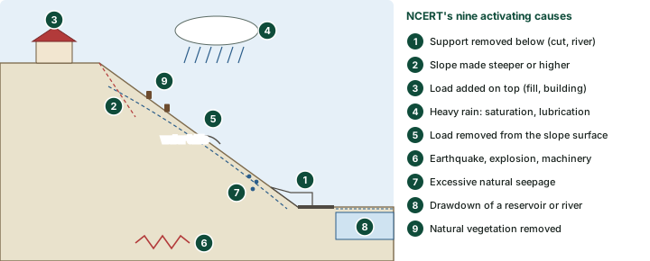
Of all these, water stands out. The USGS calls slope saturation by water "a primary cause of landslides", whether it comes as intense rainfall, snowmelt, changes in groundwater level, or changes in water level along coasts, earth dams and the banks of lakes, reservoirs, canals and rivers (USGS). That is why landslides and floods so often come together, and why debris flows and mudflows in small, steep channels are often mistaken for floods.
Fast and slow: placing the movements on a scale
NCERT refers to a chart of "the relationships among different types of mass movements, their relative rates of movement and moisture limits". Two things decide where a movement falls: how fast it goes, and how much water the moving mass holds. Speed has an agreed scale. These notes use the velocity classes in Hungr, Leroueil and Picarelli (2014), an update of the Varnes classification, which follow WP/WLI (1995) and Cruden and Varnes (1996).
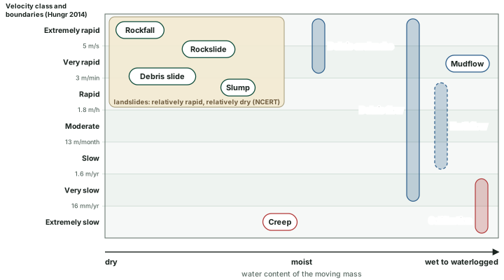
Landslide velocity classes
| Class | Description | Velocity range | Response (Hungr) |
|---|---|---|---|
| 7 | Extremely rapid | > 5 m/s | Nil |
| 6 | Very rapid | 3 m/minute to 5 m/s | Nil |
| 5 | Rapid | 1.8 m/hour to 3 m/minute | Evacuation |
| 4 | Moderate | 13 m/month to 1.8 m/hour | Evacuation |
| 3 | Slow | 1.6 m/year to 13 m/month | Maintenance |
| 2 | Very slow | 16 mm/year to 1.6 m/year | Maintenance |
| 1 | Extremely slow | < 16 mm/year | Nil |
Source: Hungr, O., Leroueil, S. and Picarelli, L. (2014), "The Varnes classification of landslide types, an update", Landslides (April 2014), doi:10.1007/s10346-013-0436-y, Table 2 (after WP/WLI 1995 and Cruden and Varnes 1996). Ranges are read from the class boundaries in the table.
Slow movements
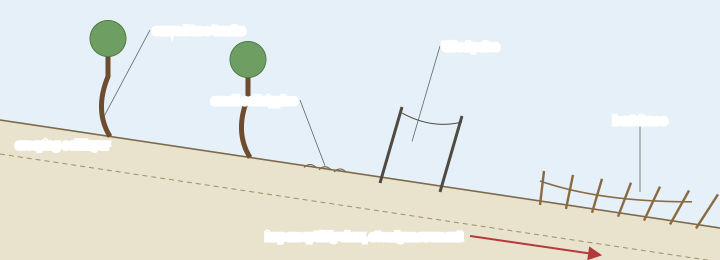
Creep is "the imperceptibly slow, steady, downward movement of slope-forming soil or rock" (USGS). The stress is enough to cause permanent deformation but too small to cause failure. The USGS recognises three types: seasonal, within the depth of soil affected by seasonal changes in moisture and temperature; continuous, where shear stress always exceeds the strength of the material; and progressive, where a slope is nearing failure. On the velocity scale, soil creep is "extremely slow": Hungr and colleagues describe it as movement of surface soil layers, typically less than 1 m deep, driven by cyclical volume changes such as wetting and drying and frost heave, and quote rates of 0.5 to 10 mm a year (compiled by Saunders and Young, 1983). Creep shows itself in curved tree trunks, bent fences or retaining walls, tilted poles or fences, and small soil ripples or ridges (USGS).
Solifluction is "the slow downslope movement of waterlogged soil, normally at rates of 0.5 to 5.0 cm (0.2 to 2 in) per year; especially, the flow occurring at high elevations in regions underlain by frozen ground, which acts as a downward barrier to water percolation" (NPS glossary). Where it runs faster on parts of a slope it builds solifluction lobes, tongue-shaped features as much as 25 m wide and 150 m long. Hungr and colleagues call it shallow soil creep in the active layer of alpine or polar permafrost, intensified roughly tenfold by seasonal ground ice. So, to NCERT's question whether solifluction is a rapid flow: by these rates it is not; it is a slow flow.
Worked example: Where do the published speeds fall?
NPS gives solifluction rates of 0.5 to 5.0 cm a year, says rapid debris flows reach 160 km/h, and says avalanche velocities may exceed 500 km/h. Place each on the Hungr scale.
- Solifluction: 0.5 to 5.0 cm a year = 5 to 50 mm a year. The class boundary is 16 mm a year, so the slower end is "extremely slow" and the faster end "very slow".
- Rapid debris flow: 160 km/h ÷ 3.6 = 44.4 m/s, far above the 5 m/s boundary: "extremely rapid".
- Avalanche: 500 km/h ÷ 3.6 = about 139 m/s: also "extremely rapid".
- Slow debris flows, which NPS says may move less than 1 m a year, span "extremely slow" (below 16 mm a year) and "very slow" (16 mm to 1.6 m a year).
Answer: Solifluction straddles extremely slow and very slow; fast debris flows and avalanches are extremely rapid. One name, debris flow, spans most of the scale.
Rapid flows
- Earthflow: the slope material liquefies and runs out, leaving a bowl or depression at the head. Earthflows have a characteristic "hourglass" shape and usually occur in fine-grained materials or clay-bearing rocks on moderate slopes under saturated conditions (USGS).
- Mudflow: an earthflow wet enough to flow rapidly, containing at least 50 per cent sand-, silt- and clay-sized particles. Newspapers often call mudflows and debris flows "mudslides" (USGS).
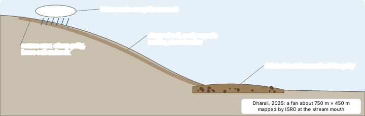
- Debris flow: loose soil, rock, organic matter, air and water mobilised as a slurry that flows downslope, with less than 50 per cent fines (USGS). NPS puts it as "more than half of the particles larger than sand size". Debris flows are commonly set off by intense surface-water flow from heavy rain or rapid snowmelt; their deposits form debris fans at the mouths of gullies, and fires that strip slopes of vegetation make them more likely (USGS).
- Lahar: a mixture of water and volcanic debris moving rapidly down the slope of a volcano, more than half of it fine-grained material (NPS glossary: lahar).
- Debris avalanche: "a variety of very rapid to extremely rapid debris flow" (USGS). NCERT notes that debris avalanches and landslides occur very frequently in the Himalayas.
Don't confuse: Snow avalanche or debris avalanche?
NPS defines an avalanche as a large mass of "snow, ice, soil, or rock, or a mixture of these" moving very rapidly under gravity, with velocities that "may exceed 500 kph", and adds that in geological writing an avalanche other than a snow avalanche carries a descriptive term, such as "debris avalanche" (NPS glossary). A snow avalanche is a hazard of snow and ice; a debris avalanche or rock avalanche is a mass movement of earth material. Keep the qualifier.
Landslides
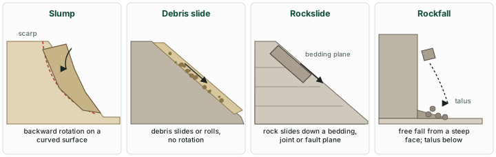
NCERT describes landslides as "relatively rapid and perceptible movements" of relatively dry material. The size and shape of the detached mass depend on the discontinuities in the rock, the degree of weathering and the steepness of the slope. NCERT names five types (table below).
NCERT's landslide types
| Type | NCERT's description | Note from other sources |
|---|---|---|
| Slump | Slipping of one or several units of rock debris with a backward rotation with respect to the slope | USGS: a rotational slide, on a surface of rupture "curved concavely upward" |
| Debris slide | Rapid rolling or sliding of earth debris without backward rotation of mass | USGS: a translational slide moves on a roughly planar surface with little rotation |
| Debris fall | Nearly a free fall of earth debris from a vertical or overhanging face | A fall of loose debris rather than solid rock |
| Rockslide | Sliding of individual rock masses down bedding, joint or fault surfaces; very fast and destructive on steep slopes | Planar failure along discontinuities such as steeply dipping bedding planes (NCERT) |
| Rock fall | Free falling of rock blocks over any steep slope, keeping away from the slope | NPS: "the most rapid type of slope movement" |
Source: NCERT, Fundamentals of Physical Geography, Class XI (reprint 2026-27), ch 5; USGS FS 2004-3072; NPS glossary: rockfall, slump.
Don't confuse: Rock fall or rockslide?
Rock fall and rockslide are not the same. NCERT: "Rock falls occur from the superficial layers of the rock face, an occurrence that distinguishes it from rockslide which affects materials up to a substantial depth." A rockfall separates along fractures, joints or bedding planes and moves by free fall, bouncing and rolling (USGS); the broken fragments collect at the foot as talus.
Landslides in India
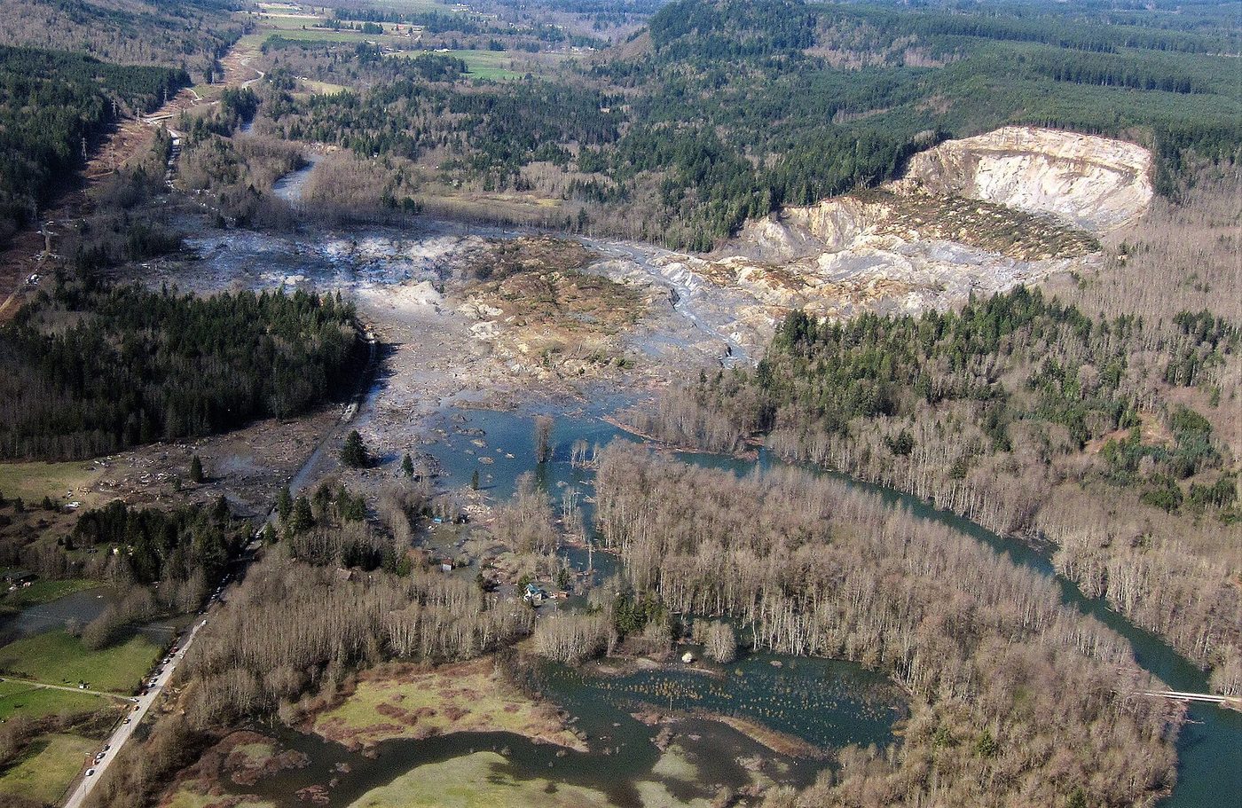
NCERT explains why debris avalanches and landslides are so frequent in the Himalayas: the range is tectonically active, made up mostly of sedimentary rocks and unconsolidated and semi-consolidated deposits, and its slopes are very steep. The Nilgiris, bordering Tamil Nadu, Karnataka and Kerala, and the Western Ghats along the west coast are relatively stable tectonically and made mostly of very hard rocks, yet landslides and debris avalanches occur there too, though less often. NCERT's reasons: many slopes are steep, with almost vertical cliffs and escarpments; mechanical weathering from temperature changes is pronounced; and heavy rain falls over short periods, so "there is almost direct rock fall quite frequently in these places". NCERT's own photograph shows landslide scars in the Shiwalik ranges near the river Sarada.
How much of India is landslide-prone depends on whose figure you take. Three government sources give three numbers, measured in different ways and published on different dates:
India's landslide-prone area: three official figures
| Source and date | Area | Other figures given |
|---|---|---|
| NRSC (ISRO), Landslide Atlas of India, 2023 (page 8; the Atlas attributes the area figure to GSI) | About 0.42 million km², 12.6% of the land area excluding snow-covered area | Inventory of landslides recorded 1998 to 2022; exposure ranking of 147 districts in 17 states and 2 UTs (page 60) |
| Geological Survey of India, note of 8 August 2024 | 4.2 lakh km² of hilly and mountainous terrain, in parts of 19 states and UTs, affecting parts of 179 districts (its state table prints a total of 433,863 km²) | 87,474 active landslides inventoried; susceptibility maps at 1:50,000 |
| Ministry of Earth Sciences, Parliament reply (PIB, 20 August 2025) | About 4.3 lakh km², in parts of 19 states and UTs | 91,000 historical landslides; 33,904 field-validated; low 245, moderate 126, high 63 thousand km² (56, 29 and 15 per cent) |
Source: as linked; MoES state table: MoES PDF. 1 lakh km² = 0.1 million km², so 4.2 lakh km² = 0.42 million km².
The figures agree closely once the units are aligned (4.2 lakh km² is 0.42 million km²). The Atlas also expresses the area as a share of land excluding snow cover. GSI's 2024 note gives 4.2 lakh km² in its text, while its own state table prints a total of 433,863 km², about 4.3 lakh km², the figure the Ministry of Earth Sciences used in 2025 for the completed national susceptibility map.
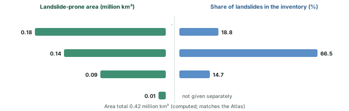
The Atlas splits the prone area by region and, separately, gives each region's share of the landslides in its inventory (NRSC Atlas, pages 8 and 58). The two do not rank the regions the same way: the North-East Himalaya has the largest prone area, but the North-West Himalaya accounts for two-thirds of the recorded landslides.
The Atlas also ranks districts by their exposure: how much population, housing, livestock and road lies in landslide-affected terrain. Rudraprayag in Uttarakhand, which the Atlas says has the highest landslide density in India, ranks first (NRSC Atlas, page 60). Exposure is not the same as hazard: a district ranks high when many people and assets sit in harm's way.
Most exposed districts, NRSC Landslide Atlas (2023)
| Rank | District | State or UT |
|---|---|---|
| 1 | Rudraprayag | Uttarakhand |
| 2 | Tehri Garhwal | Uttarakhand |
| 3 | Thrissur | Kerala |
| 4 | Rajauri | Jammu and Kashmir |
| 5 | Palakkad | Kerala |
| 6 | Poonch | Jammu and Kashmir |
| 7 | Malappuram | Kerala |
| 8 | South District | Sikkim |
| 9 | East District | Sikkim |
| 10 | Kozhikode | Kerala |
| 13 | Wayanad | Kerala |
Source: NRSC (ISRO), Landslide Atlas of India, 2023, page 60 (socio-economic exposure rank of 147 districts). District names as printed in the Atlas.
Most landslides in India occur in the monsoon months, June to September, and the Atlas places India among the four countries with the highest landslide risk; it cites Froude and Petley (2018) for India's share of 16 per cent of the world's rainfall-triggered landslide events (NRSC Atlas, page 7).
Forecasting has begun. GSI's National Landslide Forecasting Centre was inaugurated on 19 July 2024 and issues operational forecast bulletins for Darjeeling and Kalimpong (West Bengal) and the Nilgiris (Tamil Nadu), with experimental bulletins for other districts (GSI note, 2024). By the 2025 monsoon, bulletins covered 21 districts in eight states, Wayanad among them (MoES, PIB, 20 August 2025).
Recent events (2024 to 2026)
Wayanad, 30 July 2024
Wayanad, Kerala, 30 July 2024. Landslides struck the hills of Wayanad district. According to Kerala government figures given to the Lok Sabha in April 2025, 298 people died; 32 of them were missing persons declared dead (news report of the Union Home Ministry reply, 1 April 2025). The Geological Survey of India's first report (as quoted by The News Minute, 11 August 2024) assessed the trigger as the loose, unconsolidated overburden, in which excess pore pressure rose under incessant rain. This is the textbook combination described under why slopes fail, above: weak unconsolidated material (a favouring factor) and saturation by heavy rain (an activating cause). Wayanad ranks 13th in the Atlas exposure list.
Dharali, 5 August 2025
Dharali, Uttarakhand, 5 August 2025. "A catastrophic flash flood triggered by intense rainfall caused debris-laden flows over Dharali and Harsil villages, in Uttarkashi district, Uttarakhand, on the 5th August 2025" (ISRO). Cartosat-2S images taken on 7 August showed a fan-shaped deposit of sediment and debris of about 20 hectares (about 750 m by 450 m) at the confluence of the Kheer Gad and the Bhagirathi, and buildings buried or swept away by "intense mud flow and debris". The cause was not settled: "Scientific analysis is being carried out to ascertain the cause of the triggering event" (ISRO/NRSC, 7 August 2025). Explanations offered at the time ranged from a cloudburst (the view of the state government) to the burst of a lake dammed by a landslide; a mountaineering and disaster-response team that trekked to the Srikanth glacier found no glacial lake there (ETV Bharat, 17 August 2025).
Glacial lakes, 2024
Expanding glacial lakes (ISRO, 22 April 2024). Satellite images of the catchments of Indian Himalayan river basins, from 1984 to 2023, show that of 2,431 glacial lakes larger than 10 hectares identified in 2016-17, 676 have expanded notably since 1984, and 601 of them (89 per cent) have more than doubled. The catchments reach well beyond India: only 130 of the 676 lie within India (65 in the Indus, 7 in the Ganga and 58 in the Brahmaputra basin). Most of the expanding lakes are moraine-dammed (307). Such lakes can burst when their natural dams fail, causing glacial lake outburst floods (GLOFs); ISRO names avalanches of ice or rock among the triggers (ISRO).
Worked example: How fast did Ghepang Ghat lake grow?
ISRO reports that Ghepang Ghat glacial lake (Indus basin, Himachal Pradesh, 4,068 m) grew from 36.49 ha in 1989 to 101.30 ha in 2022. Find the percentage increase and the average yearly growth.
- Increase = 101.30 − 36.49 = 64.81 ha.
- Percentage increase = 64.81 ÷ 36.49 × 100 = 177.6 per cent.
- Years = 2022 − 1989 = 33; average growth = 64.81 ÷ 33 = 1.96 ha a year.
Answer: About 178 per cent, or 1.96 ha a year: both match ISRO's published 178 per cent and 1.96 ha a year.
Erosion and deposition
"Erosion involves acquisition and transportation of rock debris" (NCERT). Once rock has been broken up by weathering or any other process, the erosional agents (running water, groundwater, glaciers, wind and waves) remove it and carry it elsewhere, each according to its own dynamics. Abrasion by the debris they carry helps greatly. By erosion, relief degrades. Again NCERT stresses that "though weathering aids erosion it is not a pre-condition for erosion to take place". Weathering, mass wasting and erosion are the degradational processes, and "it is erosion that is largely responsible for continuous changes that the earth's surface is undergoing".
NCERT sorts the five agents in a way worth remembering. Wind, running water and glaciers are controlled by climate, and they represent the three states of matter: gas, liquid and solid. Waves and groundwater are not controlled by climate. The work of waves depends on location, the coast where land meets sea; the work of groundwater depends on the rock: "If the rocks are permeable and soluble and water is available only then karst topography develops."
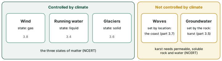
Each agent has its own part in these notes: running water, groundwater, glaciers, waves and currents and wind.
Deposition is a consequence of erosion. The agents lose velocity, and so energy, on gentler slopes, and the material they carry starts to settle. "In other words, deposition is not actually the work of any agent. The coarser materials get deposited first and finer ones later." Deposition fills depressions, and the same agents (running water, glaciers, wind, waves and groundwater) act as aggradational or depositional agents (NCERT).
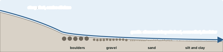
Remember
Degradation (wearing down) is done by weathering, mass wasting and erosion; aggradation (filling up) is done by deposition. NCERT keeps the word gradation for the wearing down of relief through erosion (see weathering).
Summary
- Mass movement moves material downslope under gravity alone; no agent carries it, so it is not erosion, and weathering aids it but is not required.
- Slopes fail when force exceeds shearing resistance. NCERT lists favouring factors and nine activating causes; saturation by water is a primary cause (USGS).
- Speeds run from extremely slow creep (below 16 mm a year) to extremely rapid flows and falls (above 5 m/s) on the Hungr scale. Solifluction is slow; debris flows span many classes.
- NCERT's landslides are rapid and relatively dry: slump (rotation), debris slide, debris fall, rockslide and rock fall.
- India's landslide-prone area is about 0.42 million km² (4.2 to 4.3 lakh km²), mostly in the Himalaya and the Western Ghats; three official sources give the figure on slightly different bases.
- Erosion acquires and transports debris through five agents; deposition happens when they lose energy, coarse first.
Weathering, mass movement, erosion and deposition compared
| Weathering | Mass movement | Erosion | Deposition | |
|---|---|---|---|---|
| What happens | Rock breaks down in place | Material moves downslope | Material is picked up and carried | Material settles |
| Moved by | Nothing: in situ | Gravity alone | An agent: water, ice, wind, waves | Agent loses energy |
| Needs weathering first? | No | No, but aided by it | No, but aided by it | Follows erosion |
| Effect on relief | Prepares material | Degrades slopes | Degrades relief | Fills depressions (aggradation) |
| Examples | Carbonation, frost, exfoliation | Creep, slump, rockfall, debris flow | Valley cutting, abrasion | Fans, deltas, dunes, moraines |
Source: NCERT, Fundamentals of Physical Geography, Class XI (reprint 2026-27), ch 5.
Sources
Each table and data figure names its source beneath it. The main documents are collected here, with a date where the source carries one. Figures not listed under image credits were drawn for this page from the sources stated in their source lines.
Main sources
| Topic | Source |
|---|---|
| Textbook | NCERT, Fundamentals of Physical Geography, Class XI (reprint 2026-27), ch 5 |
| Mass movement, creep, flows and landslide types | USGS Fact Sheet 2004-3072; NPS: glossary of geologic terms |
| Velocity classes | Hungr, O., Leroueil, S. and Picarelli, L. (2014), "The Varnes classification of landslide types, an update", Landslides (April 2014), doi:10.1007/s10346-013-0436-y |
| India's landslide-prone area, exposure and forecasting | NRSC (ISRO), Landslide Atlas of India (2023); Geological Survey of India, note of 8 August 2024; Ministry of Earth Sciences, Parliament reply (PIB, 20 August 2025); MoES state table (PDF) |
| Wayanad, 30 July 2024 | News report of the Union Home Ministry reply, 1 April 2025; GSI first report as quoted by The News Minute, 11 August 2024 |
| Dharali, 5 August 2025 | ISRO/NRSC, 7 August 2025; ETV Bharat, 17 August 2025 |
| Expanding glacial lakes | ISRO, "Satellite insights: expanding glacial lakes in the Indian Himalayas" (April 2024) |
Image credits
| Image | Credit and licence |
|---|---|
| Oso Landslide aerial | Mark Reid, USGS, 15 May 2014. Public domain. File page |
| All other figures | Drawn for this page from the sources given in their source lines. |