 BharatNotes
Part 2 of 7 of the Plate Tectonics and Volcanism notes. The overview page has the quick revision, exam strategy, vocabulary and key terms for all seven parts.
Continental Drift
Look at a world map and the coasts on either side of the Atlantic seem to fit like the pieces of a puzzle. In 1912 the German meteorologist Alfred Wegener turned that observation into a full theory: the continents had once been joined in a single landmass and had since drifted apart. His evidence was strong, but he could not say what force moved the continents, and most scientists rejected the idea for decades. This part sets out the theory, each line of evidence, the forces Wegener proposed and why they failed. The next part, on sea-floor spreading, shows how the ocean floor later revived the idea.
Before Wegener
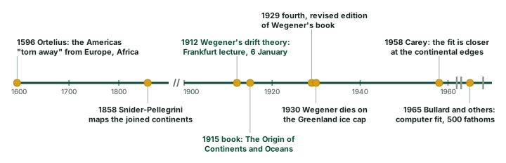
The symmetry of the coastlines on either side of the Atlantic led many scientists to wonder whether the two Americas, Europe and Africa were once joined. From the known records of the history of science, NCERT credits Abraham Ortelius, a Dutch map maker, with first proposing such a possibility, as early as 1596. USGS gives his words from the Thesaurus Geographicus: the Americas were "torn away from Europe and Africa . . . by earthquakes and floods", and "the vestiges of the rupture reveal themselves, if someone brings forward a map of the world and considers carefully the coasts of the three [continents]" (USGS, This Dynamic Earth, "Historical perspective").
In 1858 the geographer Antonio Snider-Pellegrini (NCERT calls him Antonio Pellegrini) drew two maps showing how the American and African continents may once have fitted together and later separated. Neither man offered a full theory. That came with Wegener.
Wegener's hypothesis
Alfred Wegener, a German meteorologist, put forward a comprehensive argument, "the continental drift theory", in 1912 (NCERT). He first presented it in a lecture to the Geologische Vereinigung (Geological Association) in Frankfurt am Main on 6 January 1912, and first published it in Petermanns Geographische Mitteilungen in April 1912. A short book of 94 pages, The Origin of Continents and Oceans, followed in 1915, and its fourth, revised edition appeared in 1929 (I. J. Demhardt, "Alfred Wegener's Hypothesis on Continental Drift and Its Discussion in Petermanns Geographische Mitteilungen (1912-1942)", Polarforschung 75(1), PDF). USGS notes that he was 32 years old in 1912. The timeline below sets these dates in order.
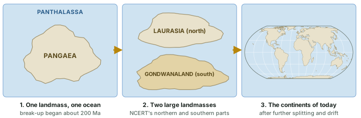
According to Wegener, all the continents once formed a single continental mass surrounded by a single great ocean:
- The supercontinent was Pangaea, which NCERT translates as "all earth" (USGS: "all lands" in Greek).
- The mega-ocean was Panthalassa, meaning "all water".
- Around 200 million years ago, Pangaea began to split (NCERT; USGS puts the start of the break-up at about 225-200 million years ago).
- It first broke into two large masses, Laurasia in the north and Gondwanaland in the south, which then broke into the smaller continents of today (diagram below).
Don't confuse: Who named Laurasia and Gondwanaland?
NCERT presents the two-part split as part of Wegener's account. USGS credits the proposal that Pangaea first broke into Laurasia and Gondwanaland to Alexander Du Toit, a professor of geology at Witwatersrand University and one of Wegener's strongest supporters (USGS, This Dynamic Earth, "Historical perspective"). Do not write that Wegener named them. India belonged to the southern mass: the section on the evidence below shows how India's Gondwana rocks match those of the other southern landmasses.
The evidence
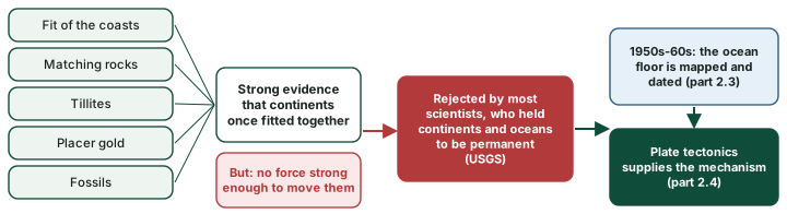
Wegener and his supporters gathered several independent lines of evidence. Each could perhaps be explained another way; together they pointed strongly to continents that had once been joined. NCERT groups them under five headings.
1. The jigsaw fit of the continents
The shorelines of Africa and South America facing each other show a remarkable and unmistakable match. But a coastline is not the true edge of a continent. As Bullard and his colleagues explained, the position of the coastline "would, in many places, be greatly changed by a small rise or fall of sea level"; the real edge is the continental slope, where the sea floor drops steeply from about 50-100 fathoms to over 2,000 fathoms (1 fathom = 6 feet, about 1.8 m). Wegener "pointed out that the fit should be made at the continental edge, but did not pursue the matter in detail". Carey (1958) was the first to show that the fit is much closer at the continental edges than at the coastline (E. Bullard, J. E. Everett and A. G. Smith (1965), "The fit of the continents around the Atlantic", Phil. Trans. R. Soc. A 258: 41-51 (PDF)).
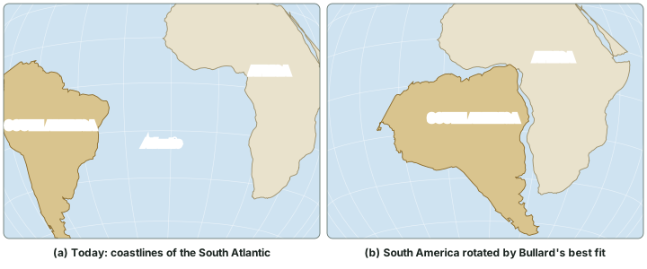
In 1965 Bullard, Everett and Smith fitted the continents around the Atlantic by computer, using a least-squares measure of misfit. Their best fit was at the 500-fathom contour, on the steep part of the continental edge, with root-mean-square errors of 30 to 90 km for the different pairs of continents. Their fit of South America to Africa is a rotation of 57° about a centre at 44.0° N, 30.6° W (500-fathom contours, longer stretch of coast). The diagram below applies that rotation to today's coastline of South America.
NCERT says 1,000 fathoms; the paper says 500
NCERT and the 1965 paper differ. NCERT says a computer map of the best fit of the Atlantic margin "was presented by Bullard in 1964", that it "proved to be quite perfect", and that the match was tried "at 1,000-fathom line". The published paper (1965) found the best fit at the 500-fathom contour; it also tested the 1,000-fathom line. Quote NCERT's figure in NCERT-based answers and know the paper's.
Worked example: How far has South America moved relative to Africa?
Bullard's fit turns South America through 57° about a centre at 44.0° N, 30.6° W. How far did a point near the eastern tip of Brazil, at 8° S, 35° W, travel?
- Rotate the point about the centre by 57°: it lands at about 4.2° N, 7.7° E, on the coast of the Gulf of Guinea.
- The angle between the two positions, measured at the Earth's centre, is 44.3°.
- Distance = angle in radians × radius = 44.3 × π ÷ 180 × 6,370 km = about 4,922 km.
Answer: About 4,900 km. NCERT's two Mesosaurus localities are now 4,800 km apart: the same order of separation.
2. Rocks of the same age across the oceans
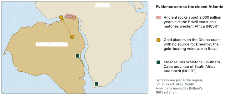
Radiometric dating has made it possible to correlate rock formations on different continents across the oceans. NCERT notes that a belt of ancient rocks 2,000 million years old on the coast of Brazil matches rocks in western Africa (see the map below). The earliest marine deposits along the coasts of South America and Africa are of Jurassic age, which suggests that the ocean between them did not exist before that time.
3. Tillite: the record of ancient ice
Tillite is sedimentary rock formed from the deposits of glaciers. NCERT says the Gondwana system of sediments in India has counterparts in six different landmasses of the Southern Hemisphere. At its base lies thick tillite, a sign of extensive and prolonged glaciation. Counterparts of this succession are found in Africa, the Falkland Islands, Madagascar, Antarctica and Australia. The overall resemblance of these Gondwana-type sediments shows that the landmasses had remarkably similar histories, and NCERT calls the glacial tillite "unambiguous evidence of palaeoclimates and also of drifting of continents".
In India these glacial deposits at the base of the Gondwana succession are the Talchir beds. USGS gives another example: glacial deposits in present-day arid South Africa, in the Vaal River valley. Glaciation on this scale in lands that now lie in the tropics and subtropics is what makes tillite evidence of drift.
Why it happens: Climate clues point to moving continents
Rocks record the climate in which they formed. Glacial tillite now lies in warm India and Africa. In Antarctica, coal seams formed from Permian swamp forests show that the continent once had a milder climate than its present ice. Research on Antarctic fossil peat shows these were high-latitude forest mires, not tropical ones (Slater, McLoughlin and Hilton (2014), "A high-latitude Gondwanan lagerstätte: the Permian permineralised peat biota of the Prince Charles Mountains, Antarctica", Gondwana Research), so the coal does not prove Antarctica was at the equator; it shows a climate warm enough for forests near the pole. Either way, the rocks do not fit the continents' present positions.
4. Placer deposits
Rich placer deposits of gold occur on the Ghana coast, yet the region has no source rock for them at all. The gold-bearing veins are in Brazil. NCERT concludes that the gold of Ghana was derived from the Brazil plateau when the two continents lay side by side.
5. The distribution of fossils
When identical species of plants and animals adapted to life on land or in fresh water are found on both sides of an ocean, their distribution needs explaining. USGS notes that Wegener regarded identical fossils along the coasts of Africa and South America as the most compelling evidence that the two continents were once joined: most of these organisms could not have swum or been carried across a vast ocean.
- Mesosaurus was a small reptile. NCERT says it was adapted to shallow brackish water and that its skeletons are found in only two localities, the Southern Cape province of South Africa and Brazil, now 4,800 km apart with an ocean between. The Geological Society calls it a freshwater reptile of the early Permian, between 286 and 258 million years ago, found in southern Africa and eastern South America (Geological Society, "Fossil Evidence from the Southern Hemisphere").
- Glossopteris was a woody, seed-bearing shrub or tree, some reaching 30 m tall, whose fossils are found in Australia, South Africa, South America, India and Antarctica (Geological Society, "Fossil Evidence from the Southern Hemisphere").
- Lystrosaurus, a land reptile of the early Triassic about 250 million years ago, is found in Antarctica, India and South Africa (Geological Society, "Fossil Evidence from the Southern Hemisphere").
- Cynognathus, a mammal-like reptile about as large as a modern wolf, of the early to mid Triassic (250 to 240 million years ago), is found in South Africa and South America (Geological Society, "Fossil Evidence from the Southern Hemisphere").
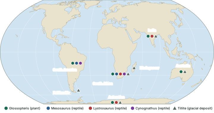
Fossils that span the southern oceans
| Fossil | What it was | Age | Found in |
|---|---|---|---|
| Mesosaurus | Small reptile; shallow brackish water (NCERT) or fresh water (Geological Society) | Early Permian, 286-258 Ma | Southern Africa; Brazil (eastern South America) |
| Glossopteris | Woody seed-bearing shrub or tree, up to 30 m | Permian | Australia, South Africa, South America, India, Antarctica |
| Lystrosaurus | Land reptile, about 1 m long, pig-like build | Early Triassic, about 250 Ma | Antarctica, India, South Africa |
| Cynognathus | Mammal-like reptile, wolf-sized | Early to mid Triassic, 250-240 Ma | South Africa, South America |
Geological Society, "Fossil Evidence from the Southern Hemisphere"; Mesosaurus habitat and localities also from NCERT, Fundamentals of Physical Geography, Class XI, chapter 4 "Distribution of Oceans and Continents" (Reprint 2025-26 edition).
Don't confuse: Lemuria
Lemurs live in India, Madagascar and Africa, and NCERT notes that this led some people to imagine a connecting landmass, "Lemuria", linking the three. Drift offers a different explanation for such shared life: the landmasses themselves were once together.
The lines of evidence for drift
| Evidence | What is observed | What it suggests |
|---|---|---|
| Fit of the coasts | Africa and South America match, best at the continental edge | They were once one block |
| Rocks of the same age | 2,000-million-year-old belt in Brazil matches western Africa; earliest coastal marine deposits are Jurassic | The rocks formed together; the ocean opened later |
| Tillite | Gondwana glacial deposits in India and other southern landmasses | One ice sheet covered lands now far apart and partly tropical |
| Placer gold | Gold on the Ghana coast; source veins in Brazil | The gold was carried before the continents separated |
| Fossils | Mesosaurus, Glossopteris, Lystrosaurus, Cynognathus on several continents | Land and freshwater life could not cross oceans |
NCERT, Fundamentals of Physical Geography, Class XI, chapter 4 "Distribution of Oceans and Continents" (Reprint 2025-26 edition); fossils Geological Society, "Fossil Evidence from the Southern Hemisphere".
The forces Wegener proposed
A theory of moving continents needs a force to move them. In his 1912 paper Wegener was cautious: he mentioned effects of the "lunar tide onto the globe" and suggested treating the movements, for the time being, "as results of accidental currents in the globe" (I. J. Demhardt, "Alfred Wegener's Hypothesis on Continental Drift and Its Discussion in Petermanns Geographische Mitteilungen (1912-1942)", Polarforschung 75(1), PDF). In the form NCERT teaches, he proposed two forces (diagram below):
- Pole-fleeing force, related to the rotation of the earth. The earth is not a perfect sphere: rotation gives it a bulge at the equator, and the force was supposed to push continents away from the poles.
- Tidal force, due to the attraction of the Moon and the Sun, which raises the tides in the oceans.
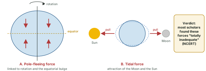
Wegener believed these forces would become effective if applied over many millions of years. Most scholars considered them totally inadequate (NCERT).
Why the theory was rejected
At the time, the scientific community firmly believed the continents and oceans to be permanent features of the Earth's surface, so drift was not well received. Its fatal weakness was the question its critics asked: what forces could be strong enough to move such large masses of solid rock over such great distances? Wegener suggested that the continents simply ploughed through the ocean floor. The English geophysicist Harold Jeffreys, USGS notes, "argued correctly that it was physically impossible for a large mass of solid rock to plow through the ocean floor without breaking up" (USGS, This Dynamic Earth, "Historical perspective"). Jeffreys doubted even the fit: as late as 1964 he wrote, "I simply deny there is an agreement" (E. Bullard, J. E. Everett and A. G. Smith (1965), "The fit of the continents around the Atlantic", Phil. Trans. R. Soc. A 258: 41-51 (PDF)).
Wegener spent the rest of his life gathering evidence. He died in 1930 during an expedition across the Greenland ice cap (USGS, This Dynamic Earth, "Historical perspective"). After his death, new evidence from exploring the ocean floor revived his ideas and led to the theory of plate tectonics (diagram below). NCERT makes the turning point clear: the evidence for drift came almost entirely from the continents, from the distribution of plants, animals and deposits such as tillite; the discoveries after the Second World War came from the ocean floor.
Worked example: How fast must the continents have moved?
NCERT's Mesosaurus localities are 4,800 km apart, and Pangaea began to split about 200 million years ago. What is the least average rate at which they moved apart?
- Convert: 4,800 km = 4,800 × 100,000 cm = 480,000,000 cm.
- They had at most 200 million years.
- Rate ≥ 480,000,000 cm ÷ 200,000,000 years = 2.4 cm a year.
Answer: At least about 2.4 cm a year on average: slow, but over 200 million years enough to open an ocean. The part on plate boundaries gives measured rates.
Where NCERT and other sources differ
| Point | NCERT | Other source |
|---|---|---|
| Meaning of Pangaea | "All earth" | "All lands" in Greek (USGS) |
| Laurasia and Gondwanaland | Presented with Wegener's split of Pangaea | Two-block division proposed by Du Toit (USGS) |
| Computer fit | Bullard, 1964; at the 1,000-fathom line | Bullard, Everett and Smith, 1965; best at 500 fathoms |
| Mesosaurus habitat | Shallow brackish water | Fresh water (Geological Society) |
| Pellegrini | "Antonio Pellegrini" drew a map | Antonio Snider-Pellegrini, two maps, 1858 (USGS) |
NCERT, Fundamentals of Physical Geography, Class XI, chapter 4 "Distribution of Oceans and Continents" (Reprint 2025-26 edition); USGS, This Dynamic Earth, "Historical perspective"; E. Bullard, J. E. Everett and A. G. Smith (1965), "The fit of the continents around the Atlantic", Phil. Trans. R. Soc. A 258: 41-51 (PDF); Geological Society, "Fossil Evidence from the Southern Hemisphere".
Exam tip
For "evidence of continental drift", name the five NCERT lines (fit, rocks, tillite, placers, fossils) with one example each, and add the Indian link: the Gondwana system and its Talchir tillite, and Glossopteris and Lystrosaurus in India. For "why was it rejected", the answer is the mechanism: Wegener's forces were far too weak, and solid continents cannot plough through the ocean floor.
Summary
Summary: the theory
- Ortelius (1596) and Snider-Pellegrini (1858) noticed the fit; Wegener (1912) made it a theory.
- Pangaea and Panthalassa; split from about 200 Ma into Laurasia and Gondwanaland.
- The fit is best at the continental edge (Carey 1958; Bullard and others 1965, 500 fathoms).
Summary: evidence and fate
- Evidence: 2,000-million-year rocks, tillite (Gondwana, Talchir), Ghana gold from Brazil, fossils (Mesosaurus, Glossopteris, Lystrosaurus).
- Forces: pole-fleeing and tidal, both "totally inadequate".
- Rejected for want of a mechanism; revived by the ocean floor (sea-floor spreading).
Sources
Each table and data figure names its source beneath it. The main documents are collected here, with a date where the source carries one. Figures not listed under image credits were drawn for this page from the data and formulas stated in their source lines.
Main sources
| Topic | Source |
|---|---|
| Textbook | NCERT Class XI, Fundamentals of Physical Geography, ch. 4, Distribution of Oceans and Continents (Reprint 2025-26 edition) |
| Continental drift | USGS, Historical perspective; Demhardt, Polarforschung (2005); Bullard and others (1965); Geological Society, fossil evidence |
| Antarctic coal and climate | Slater, McLoughlin and Hilton (2014), Gondwana Research |
Image credits
| Image | Credit and licence |
|---|---|
| Land outlines on maps | Natural Earth, 1:110m and 1:50m vectors. Public domain. |
| All other figures | Drawn for this page from the data and formulas given in their source lines. |