 BharatNotes
Part 4 of 7 of the Plate Tectonics and Volcanism notes. The overview page has the quick revision, exam strategy, vocabulary and key terms for all seven parts.
Plate Tectonics and Plate Boundaries
The ideas of the two previous parts, continental drift and sea-floor spreading, meet in one theory. Wegener showed that continents had moved; the mapping of the ocean floor showed that new floor is made at ridges and old floor disappears at trenches. Plate tectonics joins the two: the rigid outer shell of the Earth is broken into plates that move over a weaker layer below, and almost everything dramatic in geology, from mountain ranges to earthquakes and volcanoes, happens where plates meet. This part explains the plates, the three kinds of boundary between them, how fast they move, what may drive them, and what the large earthquakes of 2023 to 2025 teach about each kind of boundary.
Cross-paper relevance
- GS1 (Geography, primary): the plates, divergent, convergent and transform boundaries, rates of plate motion, the forces that may drive the plates, and where earthquakes happen
- GS3 (Disaster management): why earthquakes cluster at plate edges and along sinking slabs, and the earthquakes of 2023 to 2025 (Turkey and Syria, Noto, Hualien, Tingri, Myanmar) as case studies of faulting and loss of life; India's seismic zones are covered in the part on the Indian plate
The theory of plate tectonics
By the middle 1960s two lines of evidence were in hand. Continental drift explained why the coasts and rocks on either side of the Atlantic match, but it could not say what moved the continents. Sea-floor spreading explained how ocean floor is made at mid-ocean ridges and lost at trenches. NCERT records the step that joined them: "It was in 1967, McKenzie and Parker and also Morgan, independently collected the available ideas and came out with another concept termed Plate Tectonics." The theory says that the lithosphere, the rigid outer shell that, in NCERT's words, "includes the crust and top mantle", is broken into large pieces called plates, and that these plates move horizontally over the asthenosphere below.
NCERT defines a plate as "a massive, irregularly-shaped slab of solid rock, generally composed of both continental and oceanic lithosphere", and adds that plates "move horizontally over the asthenosphere as rigid units". Two words in that definition carry the theory. Rigid means a plate does not bend or stretch much in its interior, so its deformation is concentrated at its edges; that is why earthquakes and volcanoes are strung out in narrow belts. Both continental and oceanic means a plate is not the same thing as a continent. The South American plate, for example, carries the continent and the western half of the South Atlantic floor as one unit.
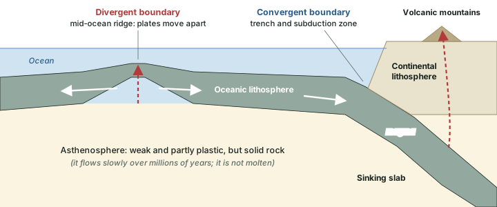
How thick is a plate? The answer depends on its age and kind, and the sources word it differently. NCERT's chapter 4 gives the lithosphere a thickness of 5 to 100 km in oceanic parts and about 200 km in the continental areas; NCERT's chapter 3 gives a single range, "10-200 km". The USGS gives "less than 15 km for young oceanic lithosphere to about 200 km or more for ancient continental lithosphere". All three say the same thing in different words: oceanic plates are thin, especially near the ridges where they form, and the old cores of continents have the thickest roots. Below the lithosphere lies the asthenosphere. It is hot and weak enough to flow very slowly, but it is solid rock: the USGS calls it "semi-solid material, which can soften and flow". The part on the interior of the Earth describes these layers in full.
Key idea: Plates move, not continents
NCERT puts it directly: "It is not the continent that moves as believed by Wegener. Continents are part of a plate and what moves is the plate." The continents ride on plates the way luggage rides on an airport belt; the ocean floor is part of the same belt.
Don't confuse: Lithosphere is not the same as crust
Lithosphere is the rigid outer shell: the crust plus the uppermost part of the mantle (NCERT). Crust is only the outermost layer, above the Moho discontinuity (see the part on the interior of the Earth). A plate is a piece of lithosphere, so every plate includes some mantle rock under its crust.
The theory also explains Pangaea in a new way. NCERT notes that all the continents were once together as Pangaea, which was itself "a result of converging of different continental masses that were parts of one or the other plates". The continental masses resting on the plates, NCERT adds, "have been wandering all through the geological period". Using palaeomagnetic data, scientists have worked out where each landmass lay in past geological periods; NCERT notes that the position of the Indian subcontinent is "traced with the help of the rocks analysed from the Nagpur area", a story the part on the Indian plate takes up.
The plates of the world
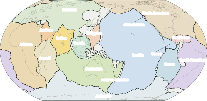
NCERT says the lithosphere "is divided into seven major and some minor plates", and that "Young Fold Mountain ridges, trenches, and/or faults surround these major plates". Its list is the one exam answers use. Research models divide the lithosphere more finely. The model most often used for world maps is PB2002, published by Peter Bird in 2003: it has 52 plates, 14 large ones and 38 small ones. Bird does not divide five regions into plates (the Alps-Persia-Tibet mountain belt, the Philippine Islands, the Peruvian Andes, the Sierras Pampeanas and the California-Nevada zone); he marks them as "orogens", 13 cross-hatched areas on his map, where the model is not expected to be accurate, because there the deformation is spread over wide zones rather than along clean lines.
The plates in numbers
- 7 + minor: major plates in NCERT, plus minor plates
- 52: plates in the PB2002 model (14 large, 38 small)
- ~260,000 km: total length of PB2002 boundaries (computed)
NCERT's seven major plates and their counterparts in the PB2002 model
| No. | NCERT's wording | PB2002 plate(s) |
|---|---|---|
| I | Antarctica and the surrounding oceanic plate | Antarctica |
| II | North American (with western Atlantic floor separated from the South American plate along the Caribbean islands) | North America |
| III | South American (with western Atlantic floor separated from the North American plate along the Caribbean islands) | South America |
| IV | Pacific plate | Pacific |
| V | India-Australia-New Zealand plate | India and Australia, two plates in PB2002 |
| VI | Africa with the eastern Atlantic floor plate | Africa (Nubia) and Somalia, split along the East African Rift |
| VII | Eurasia and the adjacent oceanic plate | Eurasia, with small plates such as Amur, Yangtze, Sunda and Okhotsk at its edges |
NCERT wording from NCERT, Fundamentals of Physical Geography, Class XI, chapter 4 "Distribution of Oceans and Continents" (Reprint 2025-26). Plate names from Bird, P. (2003), "An updated digital model of plate boundaries", Geochemistry, Geophysics, Geosystems 4(3), 1027, doi:10.1029/2001GC000252, read from the PB2002 plate file.
The Pacific plate is the largest, and it is almost wholly ocean floor: NCERT calls it "largely an oceanic plate", while the Eurasian plate "may be called a continental plate". The USGS notes that plate size "can vary greatly, from a few hundred to thousands of kilometers across", and that "the Pacific and Antarctic Plates are among the largest". Plates also change with time. The small Juan de Fuca plate off the coast of Oregon and Washington is, in the USGS's words, "a remnant of the formerly much larger oceanic Farallon Plate", and it is still sinking beneath North America.
Exam tip: Seven or fifty-two?
For a question on the number of plates, give NCERT's answer (seven major plates and several minor ones) and, where the answer allows, add that modern models such as PB2002 (Bird, 2003) recognise 52. Name the basis of each figure; neither is wrong, they answer different questions.
NCERT's important minor plates
| Plate | Location, in NCERT's words |
|---|---|
| Cocos | Between Central America and Pacific plate |
| Nazca | Between South America and Pacific plate |
| Arabian | Mostly the Saudi Arabian landmass |
| Philippine | Between the Asiatic and Pacific plate |
| Caroline | Between the Philippine and Indian plate (North of New Guinea) |
NCERT, Fundamentals of Physical Geography, Class XI, chapter 4 "Distribution of Oceans and Continents" (Reprint 2025-26).
Three kinds of plate boundary
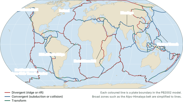
Plates can do only three things relative to a neighbour: move apart, move together, or slide past. Each gives a kind of boundary, and NCERT defines them in words worth learning exactly. Divergent: "Where new crust is generated as the plates pull away from each other"; the places where plates move apart are called spreading sites. Convergent: "Where the crust is destroyed as one plate dived under another"; NCERT adds, "The location where sinking of a plate occurs is called a subduction zone." Transform: "Where the crust is neither produced nor destroyed as the plates slide horizontally past each other".
The USGS adds a fourth category that helps with real maps: plate-boundary zones, "broad belts in which boundaries are not well defined and the effects of plate interaction are unclear". The Mediterranean-Alpine region between the Eurasian and African plates is its example, with several microplates caught between the two large ones. On a world map these zones are drawn as single lines, which is a simplification.
Length of plate boundaries in the PB2002 model, by class (computed)
| Boundary class (Bird 2003) | Kind | Length (km) | Share |
|---|---|---|---|
| Oceanic spreading ridge | Divergent | 67,300 | 26% |
| Continental rift boundary | Divergent | 27,500 | 11% |
| Subduction zone | Convergent | 51,300 | 20% |
| Oceanic convergent boundary | Convergent | 17,400 | 7% |
| Continental convergent boundary | Convergent | 23,000 | 9% |
| Oceanic transform fault | Transform | 47,800 | 18% |
| Continental transform fault | Transform | 26,100 | 10% |
| All boundaries | 260,500 | 100% |
Computed from Bird's PB2002 steps file (Bird, P. (2003), "An updated digital model of plate boundaries", Geochemistry, Geophysics, Geosystems 4(3), 1027, doi:10.1029/2001GC000252): the great-circle length of each of its 5,819 boundary steps, summed by class, on a sphere of radius 6,371 km and rounded to the nearest 100 km. Shares may not add to 100% because of rounding.
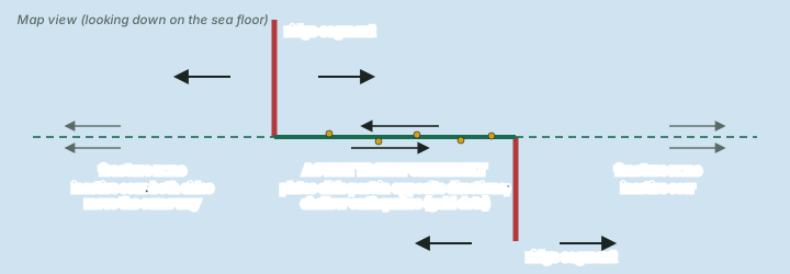
The table shows something a map hides. In PB2002, divergent boundaries make up about 36% of the total length, convergent boundaries about 35% and transform faults about 28% (computed). Transform faults are individually short but numerous, because they cut the ridges into many segments (map above).
Divergent boundaries: where plates move apart
Mid-ocean ridges
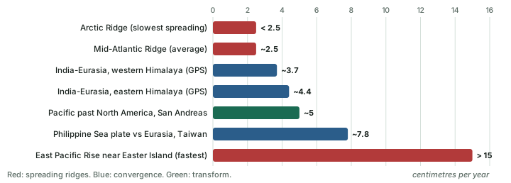
Most divergent boundaries lie under the sea, along the crests of mid-ocean ridges (the part on sea-floor spreading describes their relief). As two plates move apart, new crust is created, in the USGS's words, "by magma pushing up from the mantle". NCERT describes the ridge as "characterised by a central rift system at the crest", and adds that this rift system "is the zone of intense volcanic activity"; earthquakes there are shallow. NCERT names the best-known example: the Mid-Atlantic Ridge, where "the American Plate(s) is/are separated from the Eurasian and African Plates". The USGS gives its average spreading rate as "about 2.5 centimeters per year (cm/yr), or 25 km in a million years", slow by human standards but enough, over 100 to 200 million years, to have opened the whole Atlantic.
Iceland is a piece of the Mid-Atlantic Ridge that stands above sea level, so the process can be watched on land. The USGS describes Iceland as "splitting along the spreading center between the North American and Eurasian Plates". Around Krafla volcano in the north-east, rifting episodes between 1975 and 1984 widened the ground by a total of about 7 m (USGS).
Continental rifts
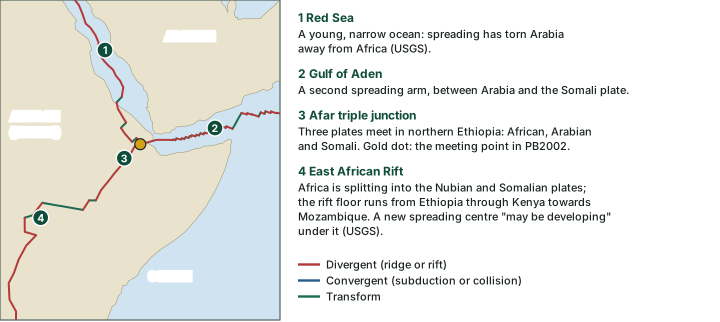
A divergent boundary can also begin inside a continent. The crust is stretched and thinned, blocks drop down between faults to form a long rift valley, and magma rises through the cracks. If stretching goes on, the rift floor sinks below sea level, the sea floods in and true ocean crust begins to form; given enough time a wide ocean with a ridge in the middle results. The Red Sea is a young ocean at that middle stage. In the USGS's words, "spreading processes have already torn Saudi Arabia away from the rest of the African continent, forming the Red Sea".
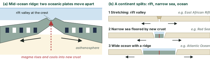
The best place to see a continental rift is East Africa. The Arabian plate is moving away from Africa along the Red Sea and the Gulf of Aden, and the two arms meet a third, the East African Rift, in the Afar region of northern Ethiopia. Such a meeting point of three plates is called a triple junction. The Geological Society of London describes the African plate as "becoming stretched along the line of the East African Rift Valley and is splitting to form two new plates; the Nubian and Somalian Plates". The rift floor, with its chain of lakes, runs "from northern Ethiopia through Kenya and southward to Mozambique" (Penn State). The USGS is careful with its tense: "A new spreading center may be developing under Africa along the East African Rift Zone." If spreading continues, the USGS adds, the Horn of Africa could one day become a large island.
Don't confuse: Rift lakes
Not every big African lake is a rift lake. Lake Tanganyika lies in the rift: it is about 650 km long and about 1,470 m deep. Lake Victoria, the largest, does not: Penn State notes that it "lies in a broad depression on the high topography of the Kenya plateau, rather than within the rift itself".
Convergent boundaries: where plates meet
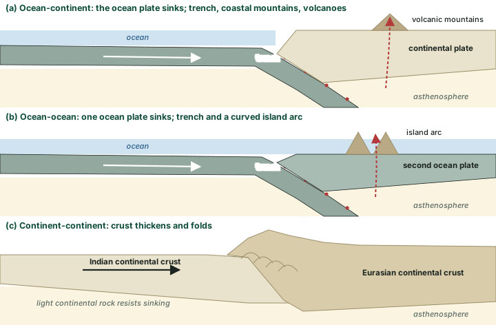
The Earth is not growing, so crust made at the ridges must be destroyed somewhere at about the same rate. The USGS notes that the planet's size "has not changed significantly during the past 600 million years". The destruction happens at convergent boundaries. What happens there depends on what each plate carries at its leading edge, because oceanic lithosphere is dense and can sink, while continental crust is light and resists sinking. NCERT names three cases: convergence "between an oceanic and continental plate", "between two oceanic plates" and "between two continental plates".
Ocean-continent convergence
When an oceanic plate meets a continent, the denser oceanic plate bends down and sinks beneath it. A deep, narrow trench marks the line where it goes down; the USGS describes trenches around the Pacific as "thousands of kilometers long and 8 to 10 km deep". Off South America the oceanic Nazca plate is sinking beneath the continental South American plate along the Peru-Chile Trench, and the overriding edge has been raised into the Andes. Subduction also feeds chains of volcanoes such as those of the Andes and the Cascade Range, though the USGS notes that scientists "vigorously debate" whether the magma comes from partial melting of the sinking slab, of the overlying plate, or of both. Parts of the sinking plate stay locked for long periods and then slip suddenly. Off South America, the USGS notes, "Strong, destructive earthquakes and the rapid uplift of mountain ranges are common in this region."
Ocean-ocean convergence
When two oceanic plates meet, one sinks beneath the other, again forming a trench. Volcanoes grow on the sea floor of the overriding plate until they rise above sea level as a curved chain of islands, an island arc, parallel to the trench. The Mariana Trench, where the USGS says "the fast-moving Pacific Plate converges against the slower moving Philippine Plate", holds the deepest point of the oceans, the Challenger Deep: NOAA gives its depth as about 10,935 m, though other surveys give figures between about 10,900 and 11,000 m. The Mariana Islands and the Aleutian Islands are island arcs.
Continent-continent convergence
When the ocean between two continents has been used up, the continents themselves meet. Neither sinks far. The USGS puts it simply: "When two continents meet head-on, neither is subducted because the continental rocks are relatively light". Instead the crust is folded, broken by thrust faults, stacked and thickened, building the highest mountains and plateaus on Earth. The Himalaya and the Tibetan Plateau, formed as India met Asia, are the standard example; the part on the Indian plate tells that story in detail. The Alps are another collision belt, formed in the wider convergence of Africa and Eurasia, where several small plates make the picture complicated.
Read the landforms
- Trench + coastal mountains + volcanoes: ocean-continent (Andes).
- Trench + island arc: ocean-ocean (Mariana, Aleutians).
- No trench, no volcanic arc, very high mountains and a plateau: continent-continent (Himalaya and Tibet).
Transform boundaries: where plates slide past
At a transform boundary the plates grind sideways past each other, so crust is neither made nor destroyed. The USGS credits the concept to the Canadian geophysicist J. Tuzo Wilson, who proposed that these large faults connect two spreading centres or, less often, two trenches. Most transform faults are on the ocean floor, where they cut the ridges into offset segments and give the ridge its zig-zag outline; NCERT describes them as "the planes of separation generally perpendicular to the mid-oceanic ridges", and the USGS notes that they are "generally defined by shallow earthquakes".
Only the stretch of the fault between two ridge segments is active, because only there do the two sides move in opposite directions. Beyond the ridge ends the fault continues as a fracture zone, a scar on the sea floor across which both sides move the same way. The USGS says some fracture zones are hundreds to thousands of kilometres long and as much as 8 km deep; the Clarion, Molokai and Pioneer fracture zones off California and Mexico are examples that are no longer active.
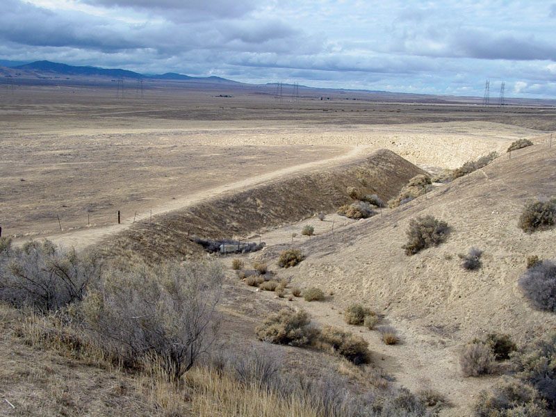
A few transforms run across land. The best known is the San Andreas Fault zone in California, which the USGS describes as "about 1,300 km long and in places tens of kilometers wide". It links the East Pacific Rise to the south with the Gorda, Juan de Fuca and Explorer ridges to the north. Land west of the fault, on the Pacific plate, moves north-west relative to land east of it, on the North American plate; the USGS gives an average rate of about 5 cm/yr over the last 10 million years. Because the fault locks and then slips, its motion comes in sudden jumps: the San Francisco earthquake of 18 April 1906 had a moment magnitude (Mw) of 7.9 in the USGS catalogue. Another land transform, the Dead Sea Transform, is a left-lateral fault separating the Arabian plate from the Sinai part of the African plate, with some opening across it as well.
Worked example: How far has the San Andreas Fault moved?
The USGS says the Pacific plate has moved past the North American plate along the San Andreas Fault at an average of about 5 cm/yr for 10 million years. How far is that in total?
- Distance = rate × time.
- Rate = 5 cm/yr; time = 10,000,000 years.
- Distance = 5 × 10,000,000 = 50,000,000 cm.
- 1 km = 100,000 cm, so the distance is 50,000,000 ÷ 100,000 = 500 km.
Answer: About 500 km of sideways movement (computed from the USGS average rate). A rock body cut by the fault should now lie that far from its other half, which is how geologists check such rates in the field.
Comparing the three kinds of plate boundary
| Divergent | Convergent | Transform | |
|---|---|---|---|
| Plate motion | Apart | Together | Side by side |
| Crust | Created | Destroyed or thickened | Neither created nor destroyed |
| Landforms | Ridge with central rift; rift valley | Trench, volcanic arc, fold mountains | Offset ridges, fracture zones |
| Earthquakes | Shallow | Shallow to several hundred km deep | Shallow |
| Volcanoes | Along the ridge crest | Above subduction zones | Not characteristic |
| Examples | Mid-Atlantic Ridge, East African Rift | Andes, Mariana arc, Himalaya | San Andreas, Dead Sea Transform |
Compiled from NCERT, Fundamentals of Physical Geography, Class XI, chapter 4 "Distribution of Oceans and Continents" (Reprint 2025-26), USGS, This Dynamic Earth, "Understanding plate motions" and USGS, This Dynamic Earth, "Developing the theory".
How fast do plates move?
Plate speeds are measured in centimetres a year, yet over millions of years they add up to thousands of kilometres. There are three ways to measure them. The first uses the magnetic stripes of the ocean floor: NCERT explains that the strips of normal and reverse magnetism parallel to the ridges "help scientists determine the rates of plate movement", since the age of each stripe is known and its distance from the crest can be measured. The second matches a rock formation of known age on both sides of a boundary and measures how far apart the two halves now are. The third, since the late 1970s, is space geodesy (very long baseline interferometry, satellite laser ranging and GPS), which measures the motion of fixed points directly. The USGS notes that rates measured over a few years "compare well" with rates averaged over millions of years.
The rates vary a great deal. NCERT gives the two ends of the range for spreading ridges: the Arctic Ridge is the slowest, at "less than 2.5 cm/yr", and the East Pacific Rise near Easter Island, "about 3,400 km west of Chile", is the fastest, at "more than 15 cm/yr".
Worked example: The age of the sea floor from its distance to the ridge
A sample of basalt is taken 500 km from the crest of a ridge. That side of the ridge has moved away from the crest at a steady 2.5 cm/yr. How old is the sample?
- Distance = 500 km = 50,000,000 cm.
- Time = distance ÷ rate = 50,000,000 ÷ 2.5 = 20,000,000 years.
- Check which rate a question gives. A "spreading rate" may be the full rate at which the two plates separate; each side then moves away from the crest at half that rate, and the age doubles.
Answer: About 20 million years (computed). This is how the age of the sea floor is related to distance from the ridge.
What drives the plates?
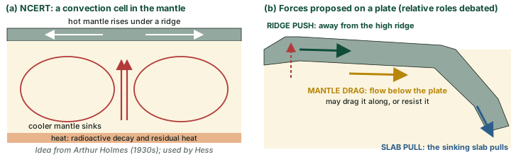
NCERT teaches the convection explanation. Heat inside the Earth comes from "radioactive decay and residual heat"; hot mantle rises, spreads and cools, and sinks again, forming convection cells. "Arthur Holmes first considered this idea in the 1930s, which later influenced Harry Hess’ thinking about seafloor spreading." NCERT concludes: "The slow movement of hot, softened mantle that lies below the rigid plates is the driving force behind the plate movement."
Research, however, has not settled the matter. The USGS states that "one of the chief outstanding questions is the one Wegener failed to resolve: What is the nature of the forces propelling the plates?" Three forces are discussed, and their names describe them: ridge push, a push away from the high ground of a ridge; slab pull, the pull of the slab already sinking at a trench, which is denser than the mantle around it, on the rest of the plate; and mantle drag, the drag of the flowing mantle beneath a plate, which may help or resist its motion. Geophysicists still debate the relative roles of the three. The strength of slab pull depends on how long the sinking slab is and how much denser it is than its surroundings: for a slab 500 to 1,000 km long and about 2 per cent denser, van Hinsbergen and colleagues (2011) estimate that "slab pull can be several times larger than the collisional resistance" (the part on the Indian plate explains why this matters for India).
An open question
The debate is about balance: how much of the motion comes from the flowing mantle beneath the plates (NCERT's picture), and how much from forces at the plates' own edges, the push at ridges and the pull of sinking slabs. The balance may differ from plate to plate.
Where earthquakes happen
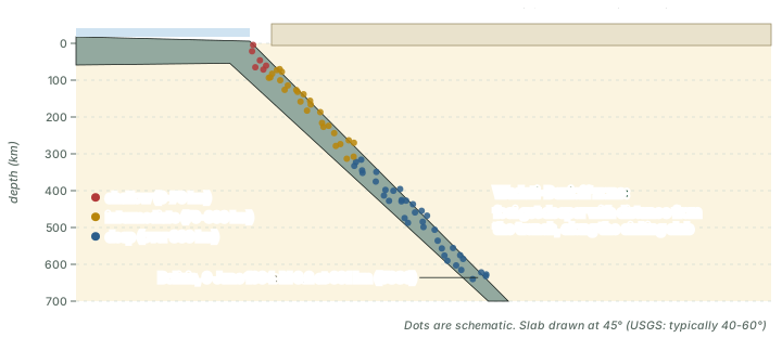
An earthquake is a sudden slip on a fault, a break in the crustal rocks; the part on the interior of the Earth explains focus, epicentre, waves and magnitude. Plate tectonics explains where earthquakes happen. Because plates are rigid, their relative motion is taken up at their edges, where the rocks lock by friction, store strain and then slip. NCERT notes that the foci in the area of the Mid-Oceanic Ridges are at shallow depths, whereas along the Alpine-Himalayan belt and the rim of the Pacific they are "deep-seated", and that trenches have deep-seated earthquakes while the ridges have shallow ones. According to National Geographic Education, about 90% of all earthquakes happen along the Ring of Fire, the roughly 40,000 km horseshoe of trenches and volcanic arcs that rings the Pacific; the part on volcanoes returns to it.
The deep earthquakes have a striking pattern. The USGS records that by the late 1920s seismologists had found earthquake zones "parallel to the trenches that typically were inclined 40-60° from the horizontal and extended several hundred kilometers into the Earth". These came to be called Wadati-Benioff zones, after Kiyoo Wadati of Japan and Hugo Benioff of the United States. Plate tectonics explains them at once: they mark, in the USGS's words, "the zones where oceanic lithosphere sinks back into the mantle (beneath the trenches)". The 9 June 1994 earthquake in Bolivia, magnitude 8.2 (Mw), struck at a depth of about 631 km within the slab between the Nazca and South American plates, and caused no major damage because it was so deep (USGS catalogue, USGS event page usp0006dzc; the older This Dynamic Earth text gives magnitude 8.3 and 636 km).
The pattern of seismic belts was mapped in detail only in the 1960s. The USGS notes that the Worldwide Standardized Seismograph Network was set up then to monitor compliance with the 1963 treaty banning above-ground nuclear tests; its records allowed seismologists "to map precisely the zones of earthquake concentration worldwide", and the map that emerged, with belts along ridges and trenches, helped confirm sea-floor spreading.
Don't confuse: Deep versus shallow earthquakes
Deep earthquakes, hundreds of kilometres down, lie along subduction zones in the Wadati-Benioff zone of the sinking slab. Ridges have shallow earthquakes (NCERT), and so do transform faults (USGS).
Lessons from the earthquakes of 2023 to 2025
The large earthquakes of the last few years are a good test of this part, because each one happened on a different kind of boundary, or in a place where the boundaries are complicated. Magnitudes below are the USGS moment magnitudes (Mww) unless another agency is named; other agencies sometimes give slightly different values.
Strike-slip faulting on land
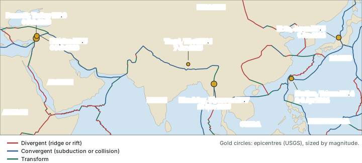
Turkey and Syria, 6 February 2023 (strike-slip). Two great shocks struck in one day. The first, M7.8 near Pazarcik at 01:17 UTC (04:17 local time), was followed 11 minutes later by an M6.7 aftershock; the second, M7.5 near Elbistan, came at 10:24 UTC (13:24 local time), about 9 hours later. Both were strike-slip ruptures on the East Anatolian fault zone, near the triple junction of the Anatolian, Arabian and African plates; that fault zone takes up the westward escape of the Anatolian block toward the Aegean. USGS impact figures (updated 15 April 2023) were at least 50,399 people killed in Turkey and at least 8,476 in Syria.
Reverse faulting in the crust
Noto Peninsula, Japan, 1 January 2024 (reverse). M7.5 (USGS; the Japan Meteorological Agency gives 7.6, provisional) at 07:10 UTC (16:10 Japan time). The USGS attributes it to "shallow reverse faulting in the Earth's crust" on the west coast of Honshu, not to the Pacific subduction interface. The ground rose by up to 4 m in western Wajima, and tsunami waves reached 6.58 m at Joetsu. Japan's Cabinet Office reported 594 people dead or missing, including 364 disaster-related deaths (as of 13 May 2025).
Reverse faulting at a convergent boundary
Hualien, Taiwan, 2-3 April 2024 (reverse). M7.4 at 23:58 UTC on 2 April, 07:58 on 3 April in Taiwan. The USGS describes "reverse faulting near the boundary between the Eurasia and Philippine Sea plates", where the Philippine Sea plate moves north-west relative to Eurasia at about 78 mm/yr; an M6.5 aftershock followed 13 minutes later. At least 17 people were killed by rockfalls (USGS). Unlike the Turkish shocks, this was reverse faulting, not strike-slip.
A continental transform
Mandalay, Myanmar, 28 March 2025 (strike-slip). M7.7 at 06:20 UTC (12:50 Myanmar time) on the right-lateral Sagaing Fault, which the USGS places "in the fault zone that defines the plate boundary between the Indian and Sunda plates". The USGS finite-fault model, informed by satellite data, makes the rupture "about 460 km by 15 km (length x width)"; separately, a surface rupture of 500 km "was confirmed through satellite observations". The first figure is the modelled fault plane, the second the break mapped at the surface, and the 15 km is the depth extent of the fault, not the width of a damage belt. USGS impact figures (updated 6 June 2025): at least 3,791 killed in Myanmar and at least 63 in Thailand. Models draw this boundary differently: in PB2002 the boundary step nearest the epicentre is a continental transform fault between the Indian and Eurasian plates, about 2 km from it (computed). The USGS summary itself uses both descriptions: faulting "between the India and Eurasia plates", on a fault in the zone of the Indian-Sunda boundary.
Extension behind a collision
Tingri, southern Tibet, 7 January 2025 (normal). M7.1 at 01:05 UTC (09:05 China time), about 80 km north-north-east of Everest (computed from the USGS epicentre). Surprisingly for the collision zone, the USGS describes "normal faulting at shallow depths north of the boundary between the Eurasia and Indian plates", on a roughly north-south fault: the crust of southern Tibet was being pulled apart east-west, not squeezed. At least 126 people were killed (USGS, updated 17 March 2025). The part on the Indian plate explains why stretching happens on top of a collision.
Large earthquakes of 2023-2025 and their tectonic setting
| Date (UTC) | Time | Mww (USGS) | Faulting | Setting | Deaths (source, as of) |
|---|---|---|---|---|---|
| 6 February 2023 | 01:17 UTC (04:17 UTC+3) | 7.8 | Strike-slip | East Anatolian fault zone; Anatolia-Arabia-Africa | At least 50,399 (Turkey) and 8,476 (Syria), USGS, 15 Apr 2023 |
| 6 February 2023 | 10:24 UTC (13:24 UTC+3) | 7.5 | Strike-slip | East Anatolian fault zone (second shock) | Included in the figures above |
| 1 January 2024 | 07:10 UTC (16:10 UTC+9) | 7.5 | Reverse (crustal) | Crust of west-coast Honshu | 594 dead or missing incl. 364 disaster-related (Cabinet Office, 13 May 2025) |
| 2 April 2024 | 23:58 UTC (07:58 UTC+8) | 7.4 | Reverse | Near the Eurasia-Philippine Sea boundary | At least 17 (USGS) |
| 7 January 2025 | 01:05 UTC (09:05 UTC+8) | 7.1 | Normal | Southern Tibet, within Eurasia north of the boundary | At least 126 (USGS, 17 Mar 2025) |
| 28 March 2025 | 06:20 UTC (12:50 UTC+6:30) | 7.7 | Strike-slip | Sagaing Fault, Indian-Sunda boundary | At least 3,791 (Myanmar) and 63 (Thailand), USGS, 6 Jun 2025 |
USGS event pages us6000jllz, us6000jlqa, us6000m0xl, us7000m9g4, us7000pn9s, us6000pi9w; Noto deaths from Cabinet Office, Government of Japan, White Paper on Disaster Management 2025, special feature chapter 1. Local times computed from the USGS UTC origin times.
Exam tip: Reading earthquake news
When an earthquake is in the news, ask three questions: which plates are involved, which kind of boundary is it, and what kind of faulting (normal, reverse or strike-slip) did it show? The answers usually match: normal faults where crust is stretched, reverse faults where it is squeezed, strike-slip where plates slide past. Tingri shows that the local answer can differ from the regional one.
Summary
- Plate tectonics (McKenzie and Parker, and Morgan, 1967, as NCERT dates it) says the rigid lithosphere is broken into plates that move over the weak, solid asthenosphere. Plates, not continents, move.
- NCERT lists seven major plates and several minor ones; the PB2002 model has 52.
- Divergent boundaries make crust (mid-ocean ridges, continental rifts such as East Africa); convergent boundaries destroy or thicken it (ocean-continent: Andes; ocean-ocean: Mariana arc; continent-continent: Himalaya); transform boundaries do neither (San Andreas, ridge offsets).
- Plates move a few centimetres a year: from under 2.5 cm/yr at the Arctic Ridge to over 15 cm/yr on the East Pacific Rise (NCERT).
- NCERT attributes plate motion to mantle convection; research still debates the roles of ridge push, slab pull and mantle drag.
- Earthquakes concentrate at plate edges; deep ones follow the sinking slab in Wadati-Benioff zones.
- The 2023-2025 earthquakes show every style of faulting: strike-slip (Turkey, Myanmar), reverse (Noto, Hualien) and normal (Tingri).
Sources
Each table and data figure names its source beneath it. The main documents are collected here, with a date where the source carries one. Figures not listed under image credits were drawn for this page from the data and formulas stated in their source lines.
Main sources
| Topic | Source |
|---|---|
| Textbook | NCERT Class XI, Fundamentals of Physical Geography, ch. 3, The Interior of the Earth; ch. 4, Distribution of Oceans and Continents (Reprint 2025-26) |
| Plates and boundaries | Bird (2003), "An updated digital model of plate boundaries", Geochemistry, Geophysics, Geosystems 4(3), 1027; USGS, Plate tectonics; USGS, Understanding plate motions; USGS, Developing the theory; USGS, Historical perspective; National Geographic, Ring of Fire |
| East African Rift | Geological Society of London, "Triple junction"; Penn State, EARTH 105, lesson 10 |
| Rates and driving forces | Banerjee and Bürgmann (2002); van Hinsbergen and others (2011) |
| Earthquakes | USGS ComCat event pages (fetched 24 October 2026): usp0006dzc, us6000jllz, us6000jlqa, us6000m0xl, us7000m9g4, us7000pn9s, us6000pi9w; Cabinet Office of Japan, White Paper on Disaster Management 2025, special feature chapter 1 |
Image credits
| Image | Credit and licence |
|---|---|
| Wallace Creek on the San Andreas Fault | USGS. Public domain. File page |
| World maps: plate boundaries | Bird (2003), PB2002 model, doi:10.1029/2001GC000252; GeoJSON conversion fraxen/tectonicplates, Open Data Commons Attribution License 1.0 |
| Land outlines on maps | Natural Earth, 1:110m and 1:50m vectors. Public domain. |
| All other figures | Drawn for this page from the data and formulas given in their source lines. |