 BharatNotes
Part 1 of 7 of the Plate Tectonics and Volcanism notes. The overview page has the quick revision, exam strategy, vocabulary and key terms for all seven parts.
Inside the Earth
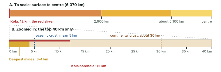
No one has ever seen the Earth's interior. The deepest borehole has gone 12 km into a planet whose radius is 6,370 km. Yet geographers describe a crust, a mantle and a two-part core with confidence, give each a depth and say which parts are solid and which are liquid. This part shows how that picture was built: from the little we can sample directly, and above all from the waves that earthquakes send through the planet. It ends with what an earthquake is and how it is measured, the base for the plate-tectonics parts that follow.
How do we know what lies inside?
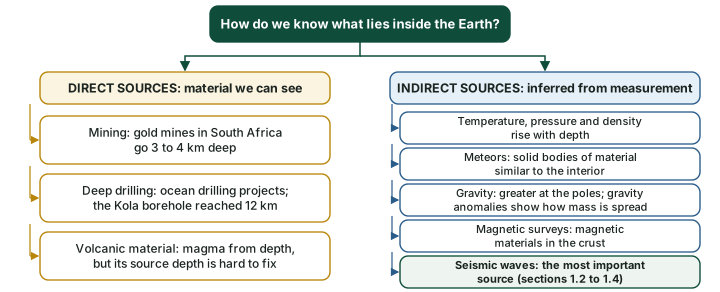
The Earth's radius is about 6,370 km (NCERT). Everything we know about its interior comes from two kinds of evidence. Direct sources are materials we can hold and test. Indirect sources are measurements made at the surface from which the interior is inferred. The diagram below sorts them.
Direct sources
Mining and drilling. The most easily available solid material is surface rock and rock brought up from mines. NCERT notes that gold mines in South Africa are as deep as 3 to 4 km; going beyond this depth is not possible because it is very hot there. Scientists have also drilled into the crust under two major projects that NCERT names, the Deep Ocean Drilling Project and the Integrated Ocean Drilling Project, and the deepest drill, at Kola, has reached a depth of 12 km. These and other deep drilling projects have provided a large volume of information through the analysis of materials collected at different depths.
Volcanic material. When a volcano erupts, molten material (magma) is thrown onto the surface and becomes available for laboratory study. NCERT's caution matters here: it is difficult to know the depth from which the magma came, so volcanic rock is a direct sample of the interior but not of a known depth.
Worked example: How far have we really gone?
The deepest borehole reached 12 km (NCERT). What share of the distance to the Earth's centre is that?
- Distance to the centre = radius = 6,370 km (NCERT).
- Share = 12 ÷ 6,370 × 100 = 0.19%.
- Scale it: if the Earth were a 1-metre ball (radius 50 cm), the borehole would be 50 cm × 12 ÷ 6,370 = 0.94 mm deep: less than a millimetre.
Answer: About 0.2% of the way. This is why the interior has to be studied indirectly.
Indirect sources
Temperature, pressure and density. Mining shows that temperature and pressure rise with depth, and density rises too. Knowing the rate of change and the total thickness of the earth, scientists have estimated the temperature, pressure and density at different depths (NCERT).
Meteors. Meteors that reach the Earth are solid bodies. Their material is not from the Earth's interior, but the material and structure seen in them are similar to the earth's: they are solid bodies that developed out of materials the same as, or similar to, our planet's (NCERT). That makes them an indirect sample.
Gravity. Gravitational attraction is greater near the poles and less at the equator, because the equator is farther from the centre than the poles are. Gravity also depends on the mass of material below a place. When a measured value differs from the expected value, the difference is a gravity anomaly, and anomalies show how mass is distributed in the crust. Magnetic surveys similarly show how magnetic materials are spread through the crust.
Seismic activity. NCERT calls it one of the most important sources of information about the interior, and the next sections explain why: the study of seismic waves "provides a complete picture of the layered interior".
Don't confuse: Meteors and volcanic rock
Meteors are not samples of the Earth's interior. They come from space. They are useful because their material and structure are similar to the interior's, so they are an indirect source. Volcanic lava, by contrast, does come from inside the Earth, so it is a direct source, even though the depth it rose from is uncertain.
Earthquakes: the probe that reaches the core
An earthquake, in simple words, is a shaking of the earth. It is a natural event caused by the release of energy, which sends out waves in all directions.
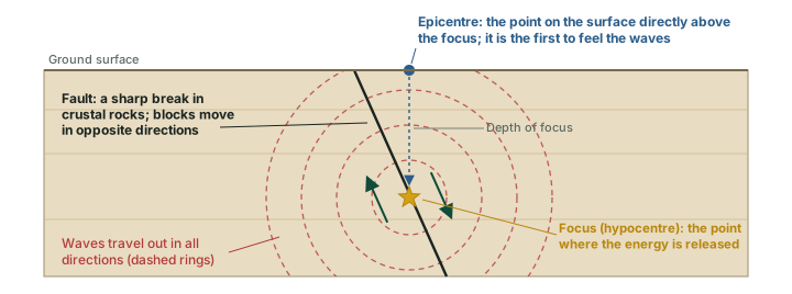
Why does the earth shake? The energy is released along a fault, a sharp break in the crustal rocks. The rocks on either side of a fault tend to move in opposite directions, but the weight of the rock above presses them together and friction locks them. Stress builds until, at some point, the tendency to move overcomes the friction. The blocks deform and then slide past one another abruptly, releasing the stored energy as waves (NCERT).
The point inside the earth where the energy is released is the focus, also called the hypocentre. The point on the surface nearest to the focus, directly above it, is the epicentre. It is the first place on the surface to experience the waves (diagram below). NCERT adds that all natural earthquakes take place in the lithosphere, which it describes here as the part of the earth up to 200 km deep.
Don't confuse: Focus and epicentre
Focus (hypocentre) is underground: the place where the rock breaks. Epicentre is on the surface: the point directly above the focus. News reports give the epicentre as a place name and the focus as a depth ("10 km deep"). Shaking is generally strongest near the epicentre and decreases away from it (see the section on magnitude and intensity below).
Earthquake waves
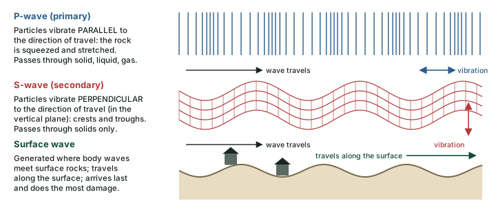
An instrument called a seismograph records the waves that reach the surface. The record (a seismogram) shows three distinct sections, each a different type of wave (diagram below). They fall into two families.
Body waves are generated by the release of energy at the focus and move in all directions through the body of the earth. Surface waves are a new set produced when body waves interact with the surface rocks; they travel along the surface. There are two kinds of body wave, P and S.
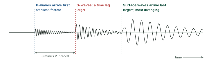
- P-waves (primary waves) move fastest and are the first to arrive. They are similar to sound waves and travel through gaseous, liquid and solid materials.
- S-waves (secondary waves) arrive with some time lag. They can travel only through solid materials. NCERT stresses that this single property has helped scientists understand the structure of the interior.
- Surface waves are the last to be recorded. They are the most destructive, because they displace rocks and cause structures to collapse.
Speed, reflection and refraction. The velocity of the waves changes as they pass through materials of different density: NCERT puts it as "the denser the material, the higher is the velocity". Their direction also changes. At a boundary between materials a wave can reflect (rebound) or refract (bend and carry on in a new direction). Seismographs all over the world record these changes in speed and direction, and they are the clues from which the layers are worked out.
The three kinds of earthquake wave
| P-wave (primary) | S-wave (secondary) | Surface wave | |
|---|---|---|---|
| Type | Body wave | Body wave | Surface wave |
| Order of arrival | First (fastest) | Second, after a time lag | Last; the most destructive |
| Vibration | Parallel to travel: squeeze and stretch | Perpendicular to travel: crests and troughs | Along the surface |
| Passes through | Solids, liquids and gases | Solids only | Travels along the surface |
| What it reveals | Bends at the core boundary: P shadow zone | Stopped by the liquid outer core: S shadow zone | Displaces rocks; structures collapse |
Source: NCERT, Fundamentals of Physical Geography, Class XI, chapter 3 "Interior of the Earth" (Rationalised 2023-24 edition).
How the waves move rock
As a wave passes, it makes the rock vibrate. In a P-wave the vibration is parallel to the direction of travel. The rock is pushed and pulled along the path, so it is alternately squeezed and stretched, creating density differences (compressions and rarefactions). In an S-wave the vibration is perpendicular to the direction of travel, in the vertical plane, so the rock is thrown into crests and troughs (diagram below). A liquid cannot spring back against this sideways shearing, which is why S-waves die out in liquids.
Remember
P = Primary = Push-pull (parallel) = passes everything. S = Secondary = Shake sideways (perpendicular) = Solids only. Surface waves arrive last but do the most damage.
Shadow zones and what they prove
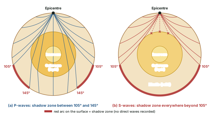
After a large earthquake, seismographs around the world record its waves, but there are some areas where waves are not recorded. Such an area is a shadow zone. Every earthquake has its own shadow zone, because the zone is fixed by the distance from that quake's epicentre, measured as an angle at the Earth's centre (NCERT).
- Seismographs within 105° of the epicentre record both P-waves and S-waves.
- Seismographs beyond 145° record P-waves but not S-waves.
- The zone between 105° and 145° is a shadow zone for both types of wave.
- The entire zone beyond 105° receives no S-waves. So the S-wave shadow zone is much larger than the P-wave shadow zone, which appears as a band around the earth between 105° and 145°.
Why it happens
Why a P-wave shadow? At the core-mantle boundary, about 2,900 km down, P-waves are refracted (bent) sharply. Rays that only graze the core carry on to about 105°; rays that enter it are bent and come out beyond 145°. No direct ray lands in between.
Why an S-wave shadow? S-waves travel only through solids. They vanish at the core boundary, so nothing beyond 105° receives them. The only explanation that fits is that the outer core is liquid.
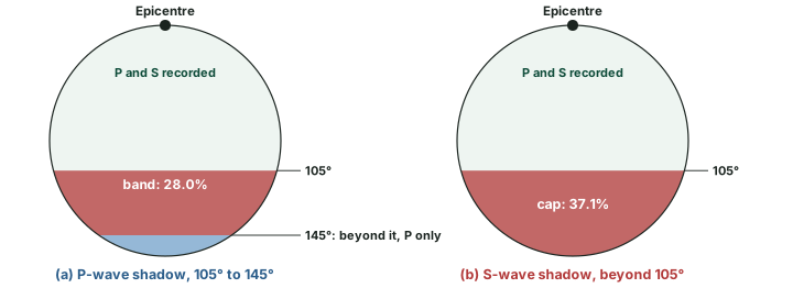
NCERT says the S-wave shadow zone covers "a little over 40 per cent of the earth surface". Simple geometry lets you check the figures behind both shadows.
Worked example: How big are the shadow zones?
On a sphere, the share of the surface lying farther than an angle θ from a point is (1 + cos θ) ÷ 2. Use it for the S-wave shadow (beyond 105°) and the P-wave band (105° to 145°).
- Beyond 105°: (1 + cos 105°) ÷ 2 = (1 − 0.2588) ÷ 2 = 0.371, about 37% of the surface.
- Beyond 145°: (1 + cos 145°) ÷ 2 = (1 − 0.8192) ÷ 2 = 0.090.
- P-wave band = 0.371 − 0.090 = 0.280, about 28%.
- So on the 105° boundary NCERT quotes, the S-wave shadow is about 37% of the surface; NCERT's "a little over 40 per cent" is larger than this geometric value.
Answer: S-wave shadow about 37% (computed from 105°); P-wave band about 28%. For exam answers quote NCERT's "a little over 40 per cent", and know that the 105° figure gives about 37%.
From observation to inference
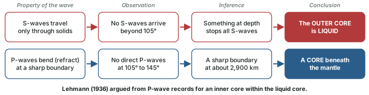
The reasoning is worth setting out step by step, because it is the core of how the interior is known (diagram below). Each conclusion rests on a wave property and an observation, not on direct sight.
The inner core was found later, also from P-waves. In 1936 the seismologist Inge Lehmann published a paper titled P', using measurements of a 1929 New Zealand earthquake, which argued for an inner core inside the liquid one. Before then the common view was of two layers, a liquid core and a solid mantle (Niels Bohr Institute, University of Copenhagen, "P' or the discovery of the Earth's core"). Today the inner core is described as solid (NCERT; USGS).
The layers: crust, mantle and core
The changes in wave speed and direction reveal a layered Earth (diagram below). USGS notes that the three main layers, crust, mantle and core, were identified around the turn of the 20th century. The boundaries between layers, where the waves change speed sharply, are called discontinuities.
The crust
The crust is the outermost solid part of the earth, and it is brittle. It is thinner under the oceans than under the continents: NCERT gives a mean thickness of 5 km for oceanic crust and around 30 km for continental crust. The crust is thicker under major mountain systems, as much as 70 km under the Himalaya. USGS gives the same averages and notes that under large ranges such as the Alps or the Sierra Nevada the base of the crust can be as deep as 100 km (USGS, This Dynamic Earth, "Inside the Earth"). Quote NCERT's 5, 30 and 70 km in the exam.
The base of the crust is the Moho, which NCERT calls "Moho's discontinuity" (in full, the Mohorovičić discontinuity). It is a boundary of rock type: below it lies the denser rock of the mantle.
The mantle
The mantle extends from the Moho to a depth of 2,900 km (NCERT; USGS describes it as a dense, hot layer of semi-solid rock about 2,900 km thick). Its upper portion is the asthenosphere, from astheno, meaning weak. NCERT says it is considered to extend to about 400 km and that it is the main source of the magma that reaches the surface in volcanic eruptions (see volcanoes and eruptions). The lower mantle lies beyond the asthenosphere and is solid.
The core
Earthquake wave velocities revealed the core. The core-mantle boundary lies at a depth of 2,900 km (NCERT), often called the Gutenberg discontinuity. The outer core is liquid and the inner core is solid. The core is made of very heavy material, mostly nickel and iron, which is why it is sometimes called the nife layer (NCERT). USGS adds that the core is nearly twice as dense as the mantle, because it is metallic (an iron-nickel alloy) rather than stony, and that motion in the liquid outer core as the Earth rotates creates the Earth's magnetic field. That field, frozen into rocks, becomes key evidence for sea-floor spreading.
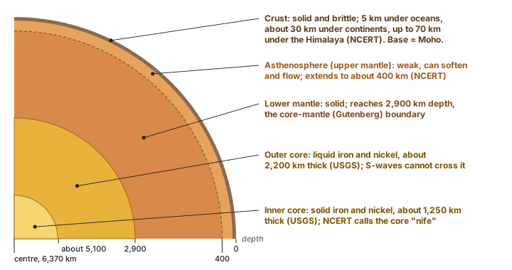
The layers at a glance
| Layer | Depth | State | Material | Seismic waves |
|---|---|---|---|---|
| Crust | Surface to the Moho: 5 km (oceans), about 30 km (continents), up to 70 km (Himalaya) | Solid, brittle | Lighter rock | P and S pass |
| Asthenosphere (upper mantle) | Below the lithosphere to about 400 km | Weak; semi-solid rock that can soften and flow | Mantle rock | P and S pass |
| Lower mantle | About 400 km to 2,900 km | Solid | Mantle rock | P and S pass |
| Outer core | 2,900 km to about 5,100 km (about 2,200 km thick) | Liquid | Iron and nickel | P passes (refracted); S stopped |
| Inner core | About 5,100 km to the centre (about 1,250 km thick) | Solid | Iron and nickel | P passes |
Source: NCERT, Fundamentals of Physical Geography, Class XI, chapter 3 "Interior of the Earth" (Rationalised 2023-24 edition); thicknesses of the core layers and "semi-solid ... can soften and flow": USGS, This Dynamic Earth, "Inside the Earth". About 5,100 km computed as 2,900 + 2,200 km.
Exam tip
Three numbers carry most questions: 2,900 km (core-mantle boundary), 105° and 145° (shadow-zone limits), and 5 / 30 / 70 km (crust under oceans, continents and the Himalaya). A question on "evidence that the outer core is liquid" wants the S-wave shadow zone.
Lithosphere and asthenosphere
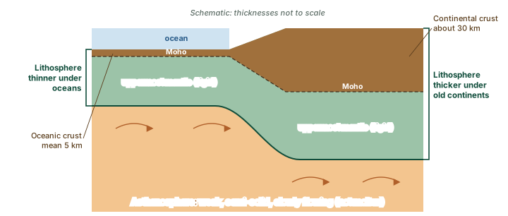
Crust, mantle and core are layers of different composition. Plate tectonics needs a second way of dividing the outer Earth, by strength. The crust and the uppermost part of the mantle together form a rigid outer shell, the lithosphere (from lithos, Greek for stone). NCERT gives its thickness as 10 to 200 km. USGS says it is thinnest under the oceans and in volcanically active continental areas (USGS, This Dynamic Earth, "Inside the Earth"), and gives plate thicknesses from less than 15 km for young oceanic lithosphere to about 200 km or more for ancient continental lithosphere (USGS, This Dynamic Earth, "Understanding plate motions: tectonic plates").
Below lies the asthenosphere. It is not molten. USGS describes it as hot, semi-solid material "which can soften and flow after being subjected to high temperature and pressure over geologic time", and the rigid lithosphere is thought to "float" or move about on it (USGS, This Dynamic Earth, "Inside the Earth"). That weak layer is what lets the plates move.
Don't confuse: Crust and lithosphere; asthenosphere and magma
Crust is not the same as lithosphere. The crust ends at the Moho; the lithosphere goes deeper and includes the rigid uppermost mantle. Asthenosphere is not liquid magma. It is solid rock that is weak and partly plastic, able to flow very slowly over geological time. Writing "molten asthenosphere" is a common error. NCERT calls it the main source of magma; how rock melts to form magma is explained in volcanoes and eruptions.
Who named it
The name "asthenosphere" is credited to the geologist J. Barrell, in 1914. Treat the year as a common attribution rather than a fact you must learn.
Types of earthquakes
NCERT lists five types by cause. Most are tectonic; the others are local and usually small.
Types of earthquakes
| Type | Cause | Where and how often |
|---|---|---|
| Tectonic | Sliding of rocks along a fault plane | The most common type; the great earthquakes described in plate boundaries are tectonic |
| Volcanic | A special class of tectonic earthquake | Confined to areas of active volcanoes |
| Collapse | Roofs of underground mines cave in | Minor tremors in areas of intense mining |
| Explosion | Explosion of chemical or nuclear devices | Ground shaking from human-made blasts |
| Reservoir induced | Linked to large reservoirs | Occur in the areas of large reservoirs |
Source: NCERT, Fundamentals of Physical Geography, Class XI, chapter 3 "Interior of the Earth" (Rationalised 2023-24 edition).
Measuring earthquakes: magnitude and intensity
Earthquakes are scaled in two quite different ways. Magnitude relates to the energy released at the source; there is one magnitude for each earthquake. The best known scale is the Richter scale, named after Charles F. Richter of the California Institute of Technology. Intensity measures the strength of shaking and the visible damage at a particular place. Its scale is named after Mercalli, an Italian seismologist; in its modified form it runs from I to XII in Roman numerals (USGS, "What Do Earthquake 'Magnitude' and 'Intensity' Mean?", page modified 30 Nov 2016).
Because intensity depends on where you stand, one earthquake has many intensities. It is highest near the epicentre and generally decreases away from it, and local ground matters: USGS notes that sites on soft ground or alluvium commonly have intensities 2 to 3 units higher than sites on bedrock.
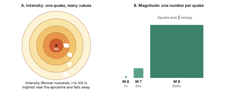
The magnitude scale is logarithmic. USGS explains that a recording of 7 means ground motion 10 times as large as a recording of 6, while the energy released is about 30 times as much; an M 8 releases about 900 times (30 × 30) the energy of an M 6. A magnitude 2 is about the smallest normally felt by people, and quakes of 5 or more are potentially damaging. NCERT expresses magnitude "in numbers, 0-10" and intensity from "1-12"; USGS points out that the Richter scale is open-ended, and that because it does not separate the largest earthquakes well, seismologists now use a moment magnitude scale. The earthquakes in plate boundaries are given as moment magnitudes (Mw).
Worked example: How much bigger is one step?
Using the USGS rule of about 30 times the energy per whole step of magnitude, compare an M 8 earthquake with an M 6, and an M 7.7 with an M 6.
- M 8 is two steps above M 6, so energy ratio = 30 × 30 = 900 (the USGS figure).
- M 7.7 is 1.7 steps above M 6, so ratio = 301.7 = about 324.
- Ground motion grows only 10 times per step: the recorded ground motion of an M 8 is 10 × 10 = 100 times that of an M 6.
Answer: About 900 times and about 324 times the energy. A "small" difference in magnitude is a very large difference in energy.
Magnitude versus intensity
| Magnitude | Intensity | |
|---|---|---|
| What it measures | Energy released at the source | Strength of shaking and damage at a place |
| Values per earthquake | One | Many: falls with distance from the epicentre |
| Scale | Richter; today moment magnitude (Mw) | Modified Mercalli |
| Numbers | Arabic numerals; NCERT: 0-10; open-ended in principle (USGS) | Roman numerals I to XII (NCERT: 1-12) |
| Depends on | The size of the earthquake | Distance from the epicentre; local ground (soft ground or alluvium shakes more) |
| Basis | Instrumental, logarithmic | Observed effects |
Source: NCERT, Fundamentals of Physical Geography, Class XI, chapter 3 "Interior of the Earth" (Rationalised 2023-24 edition); USGS, "What Do Earthquake 'Magnitude' and 'Intensity' Mean?" (page modified 30 Nov 2016).
Don't confuse: Magnitude and intensity
"An earthquake of intensity 7.8" is wrong in two ways: 7.8 is a magnitude, and intensity is written in Roman numerals (VII, VIII). Magnitude belongs to the earthquake; intensity belongs to a place.
Effects and frequency
NCERT lists the immediate hazardous effects of an earthquake: ground shaking, differential ground settlement, land and mud slides, soil liquefaction, ground lurching, avalanches, ground displacement, floods from dam and levee failures, fires, structural collapse, falling objects and tsunami. The first six have some bearing on landforms; the others are of immediate concern to life and property. A tsunami occurs only if the epicentre is below oceanic waters and the magnitude is high enough; the tsunami is a set of waves generated by the tremor, not an earthquake itself. Though the shaking lasts only seconds, NCERT notes that the effects are devastating when the magnitude is more than 5.
Not every part of the globe has major shocks, and large ones are rare. NCERT puts the frequency of quakes of magnitude 8 or more at about once in 1 to 2 years, while "tiny" ones occur almost every minute. Where they occur, along narrow belts that trace the edges of the plates, is the subject of sea-floor spreading and plate boundaries.
Summary
Summary: how we know
- Direct sources reach only a few kilometres; the deep interior is known from seismic waves.
- P-waves pass solids and liquids; S-waves pass solids only.
- The S-wave shadow beyond 105° proves a liquid outer core; the P-wave band (105° to 145°) fixes the core boundary at 2,900 km.
- P-wave records led Lehmann (1936) to an inner core, today known to be solid.
Summary: what we know
- Crust 5 / 30 / 70 km; mantle to 2,900 km; outer core liquid, inner core solid, both iron and nickel ("nife").
- Lithosphere (crust + uppermost mantle, 10-200 km) is rigid; the asthenosphere below is weak and semi-solid, not molten.
- Five types of quake (NCERT); magnitude is one number of energy, intensity is local damage, I to XII.
Sources
Each table and data figure names its source beneath it. The main documents are collected here, with a date where the source carries one. Figures not listed under image credits were drawn for this page from the data and formulas stated in their source lines.
Main sources
| Topic | Source |
|---|---|
| Textbook | NCERT Class XI, Fundamentals of Physical Geography, ch. 3, The Interior of the Earth (Rationalised 2023-24 edition) |
| Layers, lithosphere and asthenosphere | USGS, This Dynamic Earth: Inside the Earth; USGS, This Dynamic Earth, "Understanding plate motions: tectonic plates" |
| The inner core | Niels Bohr Institute, University of Copenhagen, "P' or the discovery of the Earth's core" |
| Magnitude and intensity | USGS, "What Do Earthquake 'Magnitude' and 'Intensity' Mean?" (page modified 30 Nov 2016) |
Image credits
| Image | Credit and licence |
|---|---|
| All other figures | Drawn for this page from the data and formulas given in their source lines. |