 BharatNotes
Part 5 of 7 of the Plate Tectonics and Volcanism notes. The overview page has the quick revision, exam strategy, vocabulary and key terms for all seven parts.
The Indian Plate and the Himalaya
The part on plate tectonics and plate boundaries explained plates and their boundaries. This part applies those ideas to the plate that carries India. It traces the edges of the Indian plate, its long journey north from the old southern continent of Gondwana, the speeds at which it closed on Asia, the collision that raised the Himalaya and the Tibetan Plateau, the subduction zone off the Andaman and Nicobar Islands, and what all this means for earthquakes in India today.
Cross-paper relevance
- GS1 (Geography, primary): the boundaries of the Indian plate, India's journey from Gondwana, the collision with Asia and the rise of the Himalaya and the Tibetan Plateau, present convergence
- GS3 (Disaster management): earthquakes on the plate's edges and within it, the 2004 Sumatra-Andaman earthquake and tsunami, India's seismic zones under IS 1893 (Part 1):2016
The Indian plate and its boundaries
NCERT treats India and Australia as one plate, the "India-Australia-New Zealand plate" of its list (see plate boundaries), and says that "The Indian plate includes Peninsular India and the Australian continental portions." It then walks round the plate's edges. In the north, the Himalaya mark the boundary, in the form of continent-continent convergence. In the east the boundary runs through the Arakan Yoma (Rakhine Yoma) mountains of Myanmar, which NCERT calls the "Rakinyoma Mountains", towards "the island arc along the Java Trench". On the west it follows the Kirthar range of Pakistan and the Makran coast (NCERT writes "Makrana coast"; do not confuse it with Makrana, the marble town of Rajasthan) and joins "the spreading site from the Red Sea rift southeastward along the Chagos Archipelago". In the south, the boundary with the Antarctic plate is an oceanic ridge "running in roughly W-E direction", and NCERT describes the far eastern margin as a spreading site east of Australia in the south-west Pacific.
NCERT calls the northern edge "The subduction zone along the Himalayas", but the USGS explains that when two continents meet "neither is subducted because the continental rocks are relatively light". The safest description is the one NCERT itself adds: a boundary of continent-continent convergence, where the ocean floor that once lay between India and Asia has been subducted and the continents have collided (see the section on the collision below).
Exam tip: Describing the Indian plate
For an NCERT-based answer, describe the plate as NCERT does: Peninsular India plus the Australian continental portion, bounded by the Himalaya in the north, the Myanmar-Java Trench arc in the east, Kirthar-Makran in the west and ridges in the south. Add that research models such as PB2002 treat India and Australia as separate plates.
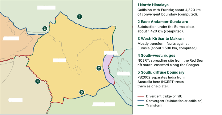
The Indian plate's neighbours in PB2002, with boundary lengths (computed)
| Neighbour (PB2002) | Boundary classes and lengths (computed) | What NCERT says about this margin |
|---|---|---|
| Eurasia | continental convergent boundary 4,320 km; continental transform fault 1,590 km; continental rift boundary 130 km | Northern margin: Himalaya, continent-continent convergence; western margin: Kirthar mountains |
| Burma | subduction zone 1,420 km; continental transform fault 500 km; oceanic convergent boundary 90 km | Eastern margin: through Myanmar towards the island arc along the Java Trench |
| Arabia | oceanic transform fault 810 km; oceanic convergent boundary 560 km; oceanic spreading ridge 280 km | Western margin along the Makran coast |
| Somalia | oceanic spreading ridge 2,490 km; oceanic transform fault 1,220 km; oceanic convergent boundary 110 km | "spreading site from the Red Sea rift southeastward along the Chagos Archipelago" |
| Australia | oceanic convergent boundary 2,310 km; oceanic spreading ridge 1,060 km; oceanic transform fault 230 km | Not a boundary in NCERT: Australia is part of the same plate |
| All neighbours | 17,110 km |
Computed from the PB2002 steps file (Bird, P. (2003), "An updated digital model of plate boundaries", Geochemistry, Geophysics, Geosystems 4(3), 1027, doi:10.1029/2001GC000252): great-circle lengths of every step between the India plate and each neighbour, rounded to 10 km (so the rows add up to 17,120 km; the total, 17,110 km, is the rounded sum of the unrounded lengths). NCERT wording from NCERT, Fundamentals of Physical Geography, Class XI, chapter 4 "Distribution of Oceans and Continents" (Reprint 2025-26).
The model and the textbook agree on the big picture and differ in detail. Because PB2002 splits India from Australia, its India plate has no boundary with Antarctica; that ridge belongs to the Australian and Antarctic plates in the model, and runs for about 11,150 km (computed). East of Australia, where NCERT places a spreading site, PB2002 draws mostly subduction and transform boundaries against the Pacific plate (about 2,160 km of subduction, computed), with short spreading segments against small plates such as Tonga and Kermadec.
The journey from Gondwana
NCERT tells the story in a few sentences. "India was a large island situated off the Australian coast, in a vast ocean." The Tethys Sea lay between it and Asia; India "is supposed to have started her northward journey about 200 million years ago at the time when Pangaea broke", and "About 140 million years before the present, the subcontinent was located as south as 50°S. latitude." NCERT's figure 4.6 shows India's positions from about 71 million years ago. On the way the lava of the Deccan Traps poured out, starting "somewhere around 60 million years ago", while "the subcontinent was still close to the equator". India "collided with Asia about 40-50 million years ago causing rapid uplift of the Himalayas".
Research papers date the stages more finely, and the dates differ from NCERT's. Van Hinsbergen and colleagues (2011) place "The establishment of the Indian plate by separation from Gondwana" at "around 130–120 Ma, upon initiation of seafloor spreading between India and Antarctica-Australia". Around 90 Ma, they write, sea-floor spreading started between Madagascar and India; around 65 Ma, after the Deccan lavas erupted, a jump of the spreading ridge transferred the Seychelles from the Indian plate to Africa. On this view the Indian plate became separate around 130-120 Ma, and Madagascar and the Seychelles broke away from it later. The part on volcanic landforms discusses the date of the Deccan Traps.
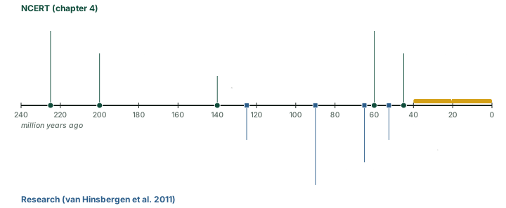
The USGS gives the same outline: "About 225 million years ago, India was a large island still situated off the Australian coast, and a vast ocean (called Tethys Sea) separated India from the Asian continent. When Pangaea broke apart about 200 million years ago, India began to forge northward." (NCERT words the first point as the Tethys separating India from Asia "till about 225 million years ago".) The USGS adds that about 80 million years ago India "was located roughly 6,400 km south of the Asian continent, moving northward at a rate of about 9 m a century".
India's journey: NCERT and research compared
| Stage | NCERT | Research and USGS |
|---|---|---|
| Start of the northward journey | About 200 Ma, as Pangaea broke | Indian plate separated from Gondwana around 130-120 Ma (van Hinsbergen 2011); USGS also gives 200 Ma for India beginning to move north |
| Position in the past | About 50° S at 140 Ma | About 6,400 km south of Asia at 80 Ma (USGS) |
| Speed | Not given | Convergence ~8 cm/yr before 66 Ma, up to ~16 cm/yr around 50 Ma, ~5 cm/yr by 35 Ma (van Hinsbergen 2011) |
| Deccan Traps | Began around 60 Ma | Around 65 Ma (van Hinsbergen 2011); see volcanic landforms |
| Collision with Asia | About 40-50 Ma | "Most authors prefer an age around 55–50 Ma for collision" (van Hinsbergen 2011); USGS: 40-50 Ma |
| Present convergence | Not given ("rising even to this date") | 37 to 44 mm/yr, west to east along the Himalaya (GPS, Banerjee and Bürgmann 2002) |
NCERT, Fundamentals of Physical Geography, Class XI, chapter 4 "Distribution of Oceans and Continents" (Reprint 2025-26); van Hinsbergen, D. J. J. et al. (2011), "Acceleration and deceleration of India-Asia convergence since the Cretaceous: Roles of mantle plumes and continental collision", Journal of Geophysical Research 116, B06101, doi:10.1029/2010JB008051, full text; USGS, This Dynamic Earth, "The Himalayas: Two continents collide"; Banerjee, P. and Bürgmann, R. (2002), "Convergence across the northwest Himalaya from GPS measurements", Geophysical Research Letters 29(13), doi:10.1029/2002GL015184, reprint.
How fast did India travel?
NCERT gives no speeds. Research measures how fast India and Asia closed on each other, which is a convergence rate between two moving plates, not India's own speed over the mantle. Van Hinsbergen and colleagues (2011) found that convergence was about 8 cm a year before 66 million years ago, then showed "an equally impressive acceleration since 66 Ma from 8 to 16 cm/yr", and later "decreased from 16 cm/yr around 50 Ma to 5 cm/yr around 35 Ma". The USGS's older account gives about 9 m a century, that is about 9 cm a year, around 80 million years ago, and says that when India met Asia "its northward advance slowed by about half". The exact numbers depend on the plate reconstruction used.
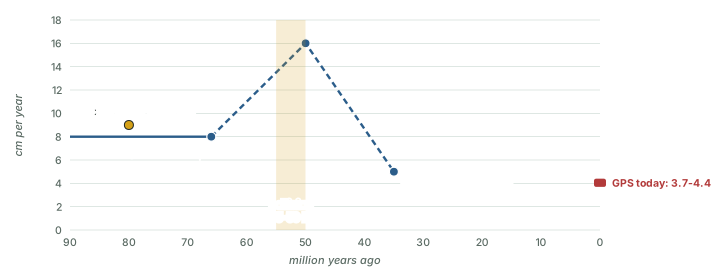
Hypothesis: Why so fast?
Why did India and Asia converge as fast as about 16 cm a year? Van Hinsbergen and colleagues conclude: "We concur with previous hypotheses that plume-induced weakening ... and an increased slab pull and ridge push efficiency are the most likely explanations". Another proposal, by Jagoutz and colleagues (2015), is double subduction, involving an additional intra-oceanic subduction zone. It is one hypothesis among several. NCERT does not discuss the cause.
Worked example: Converting plate speeds
The USGS gives India's speed around 80 Ma as about 9 m a century. Van Hinsbergen and colleagues give a rise from 8 to 16 cm/yr between 66 and 50 Ma. GPS shows Bangalore moving toward Eurasia at 40 mm/yr. Express these in comparable units.
- 9 m a century = 900 cm ÷ 100 years = 9 cm/yr.
- If the rate rose steadily from 8 to 16 cm/yr, the average is (8 + 16) ÷ 2 = 12 cm/yr.
- Over 16 million years that closes 12 cm × 16 × 1,000,000 = 192,000,000 cm = 1,920 km.
- 40 mm/yr × 100 years = 4,000 mm = 4 m a century.
Answer: About 9 cm/yr; about 1,920 km of convergence between 66 and 50 Ma if the rise was steady (computed, an assumption, not a measurement); and about 4 m a century today.
The collision and the rise of the Himalaya
For India and Asia to meet, the Tethys ocean floor between them had to be destroyed, and the part on plate boundaries shows where ocean floor is destroyed: at subduction zones. When the last of that ocean floor had gone down, Indian continental crust arrived at the boundary. Continental rock is too light to sink far, so, in the USGS's words, "The pressure of the impinging plates could only be relieved by thrusting skyward, contorting the collision zone, and forming the jagged Himalayan peaks." The range today stretches about 2,900 km (USGS). The USGS adds that the collision and the slowing of the plate "are interpreted to mark the beginning of the rapid uplift of the Himalayas", and that most of the growth of the Himalaya and the Tibetan Plateau "occurred during the past 10 million years".
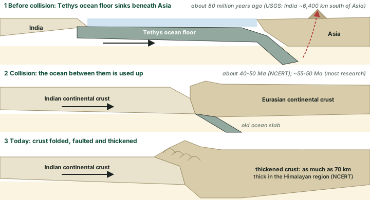
The evidence for India's northward shift is written in the rocks of Tibet too. The USGS describes pink sandstones about 50 km north of Lhasa whose magnetic minerals record the Earth's magnetic field and whose fossils show "a relatively mild, wet environment about 105 million years ago, when Tibet was closer to the equator"; since then the region has shifted north by "nearly 2,000 km" and become much drier. The Tibetan Plateau now stands at an average of about 4,600 m, "higher than all the peaks in the Alps except for Mont Blanc and Monte Rosa" (USGS). NCERT notes that the crust is "as much as 70 km thick in the Himalayan region", against about 30 km for continents in general.
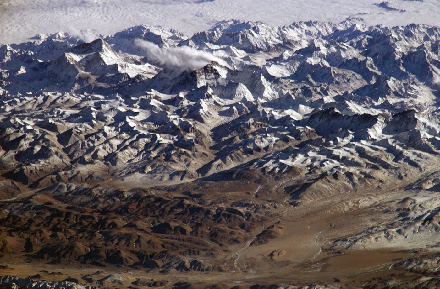
Is the Himalaya still rising? NCERT says "Scientists believe that the process is still continuing and the height of the Himalayas is rising even to this date." The rate depends on the place and the method of measurement; the USGS's older text says the range continues "to rise more than 1 cm a year". The USGS also offers an explanation for why the mountains are not higher still: "Scientists believe that the Eurasian Plate may now be stretching out rather than thrusting up, and such stretching would result in some subsidence due to gravity." The Tingri earthquake of 2025 (see the section on earthquakes in India below) is consistent with that picture: it was a normal-fault shock that pulled the crust of southern Tibet apart east-west, and GPS studies also record "east-west extension of southern Tibet" (Banerjee and Bürgmann 2002).
Remember: Dates to keep apart
NCERT: India collided with Asia about 40-50 Ma; the Himalaya formed from 40 Ma onward and are still rising. Research: collision about 55-50 Ma (most authors); convergence slowed from about 16 to about 5 cm/yr between 50 and 35 Ma; most of the height was gained in the last 10 million years (USGS).
Present convergence
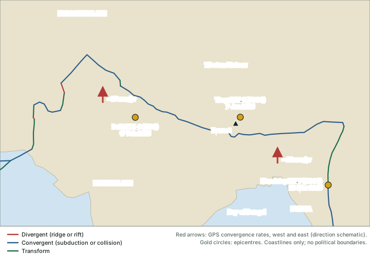
India is still moving towards Eurasia. GPS measurements analysed by Banerjee and Bürgmann (2002) show that "India-Eurasia plate convergence rates increase from 37 to 44 mm/yr from west to east along the Himalaya", and that "Station IISC near Bangalore moves towards Eurasia at 40 ± 1 mm/yr". In round numbers that is about 4 to 5 cm a year, about 4 m a century. The push is felt far beyond the Himalaya: the USGS notes that the pressure of India on Asia squeezes "parts of Asia eastward toward the Pacific Ocean", and that the resulting stresses are "relieved periodically by earthquakes along the numerous faults that scar the landscape".
Don't confuse: Past and present rates
The speeds of 8 to 16 cm a year are India-Asia convergence rates of the past. The 37 to 44 mm a year is the present convergence measured by GPS. Neither is "the speed of India" over the mantle, and the past and present figures come from different methods.
The Andaman-Sunda subduction zone
East of India the plate boundary changes character. Along the Andaman and Nicobar Islands and Sumatra, the Indian plate is not colliding with a continent but sinking beneath the plate to the east, at a subduction zone of the kind described in the part on plate boundaries. The USGS describes the setting as "ongoing subduction of the India plate beneath the overriding Burma microplate", and PB2002 draws about 1,420 km of subduction between the Indian and Burma plates (computed). The USGS adds that "the India and Australia plates move towards the north-northeast with respect to the interior of the Eurasia plate with velocities of about 60 mm/yr in the region", which produces "oblique convergence at the Sunda Trench".
On 26 December 2004 this boundary produced an earthquake of magnitude 9.1 (USGS), at 00:58 UTC (06:28 IST, computed), off the west coast of northern Sumatra. It "occurred as the result of thrust faulting on the interface of the India plate and the Burma microplate". Later modelling showed "that significant slip extended over a region up to about 1,500 km to the north of the epicenter, and that rupture lasted for more than 500 seconds"; the rupture was about 150 km wide, the slip on the fault "upwards of 20 m", and the sea floor above was uplifted by several metres, raising the tsunami that devastated the shores of the Indian Ocean. The USGS impact summary records more than 283,100 people killed and 1,126,900 displaced in 10 countries of South Asia and East Africa. On the Andaman Islands, a mud volcano near Baratang became active on 28 December.
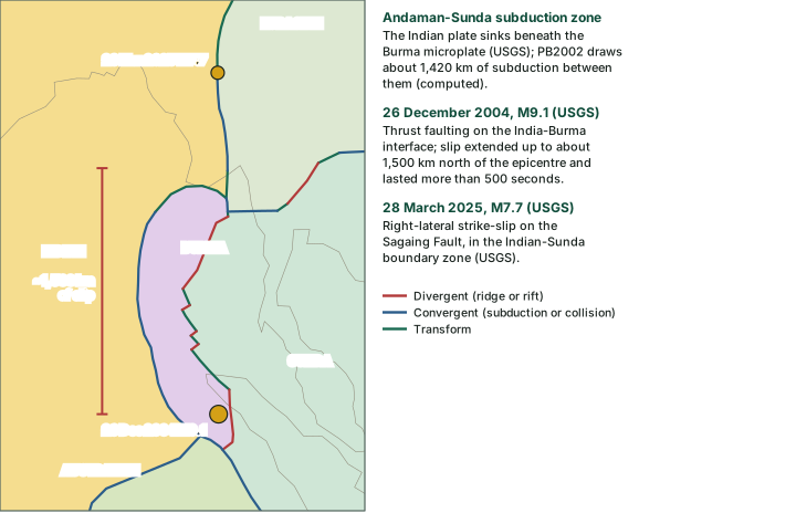
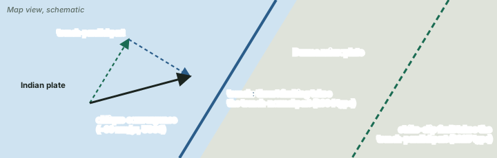
The motion is oblique, at an angle to the trench, and the USGS explains how the crust deals with it: "The oblique motion is partitioned into thrust faulting, which occurs on the interface between the India plate and the Burma microplate and involves slip directed at a large angle to the orientation of the trench, and strike-slip faulting, which occurs on the eastern boundary of the Burma microplate and involves slip directed approximately parallel to the trench." The great 2004 earthquake was the first kind. The Mandalay earthquake of 28 March 2025 was strike-slip faulting of the second kind, a right-lateral rupture on the Sagaing Fault (see plate boundaries), which the USGS places in the fault zone of the Indian-Sunda plate boundary.
Don't confuse: Burma, Sunda or Eurasia?
The USGS uses "Burma microplate" for the block east of the Andaman trench; PB2002 also has a Burma plate. In its summary of the 2025 earthquake the USGS calls the Sagaing Fault zone the boundary between the Indian and Sunda plates. Names of small plates depend on the model; the motions they describe are the same. Barren Island and Narcondam, the volcanoes of this arc, are covered in the part on volcanoes.
Earthquakes in India: zoning and recent events
Because the whole northern and eastern edge of the Indian plate is an active boundary, and because stresses reach into the plate interior too, India maps its earthquake hazard by zones. The Bureau of Indian Standards code IS 1893 (Part 1):2016 divides the country into zones numbered II to V; there is no Zone I, so Zone II is the lowest and Zone V the highest. According to press reports, a 2025 revision of the code, announced in late November 2025, added a new highest zone, Zone VI, and was withdrawn in March 2026, which left the 2016 zones in force.

In the news: Stretching in Tibet
Tingri, southern Tibet, 7 January 2025. An M7.1 earthquake (USGS) struck at 01:05 UTC (06:35 IST, computed) about 80 km north-north-east of Everest (computed). The USGS describes it as "normal faulting at shallow depths north of the boundary between the Eurasia and Indian plates", on a roughly north-south fault within the Eurasian plate. At least 126 people were killed and 3,612 homes destroyed (USGS, updated 17 March 2025); thirteen people were injured in Nepal.
In the news: A small shock under the capital
Delhi, 17 February 2025. The National Center for Seismology reported an M4.0 earthquake at 05:36:55 IST, with its epicentre at 28.59° N, 77.16° E "beneath the Jheel Park, Dhaula Kuan" and a depth of only 5 km. It was caused by normal faulting, and the maximum intensity in the epicentral area was IV on the Modified Mercalli scale.
Earthquakes in and around India discussed in these notes
| Date | Magnitude | Faulting | Setting | Effects (source, as of) |
|---|---|---|---|---|
| 26 December 2004 | M9.1 (USGS) | Thrust on the India-Burma interface | Andaman-Sunda subduction zone | More than 283,100 killed in 10 countries; tsunami across the Indian Ocean (USGS) |
| 7 January 2025 | M7.1 (USGS) | Normal | Southern Tibet, within Eurasia north of the collision boundary | At least 126 killed (USGS, 17 Mar 2025); 13 injured in Nepal |
| 17 February 2025 | M4.0 (NCS) | Normal | Delhi, within the Indian plate; depth 5 km | Maximum intensity IV (MMI) near the epicentre (NCS) |
| 28 March 2025 | M7.7 (USGS) | Right-lateral strike-slip | Sagaing Fault, Indian-Sunda boundary zone | At least 3,791 killed in Myanmar (USGS, 6 Jun 2025) |
USGS event page for the 2004 Sumatra-Andaman earthquake; USGS us6000pi9w; National Center for Seismology, "Preliminary Earthquake Report of February 17th, 2025, New Delhi (M 4.0)", Report No. NCS-NSN-EPG-2025/02 (published on seismo.gov.in); USGS us7000pn9s.
Exam tip: One plate, three styles
A shallow normal-fault shock under Delhi, a normal fault in Tibet, a great thrust off Sumatra and a strike-slip rupture in Myanmar: three styles of faulting around one plate. Matching each to its boundary (or to the plate interior) is the skill this part builds.
Summary
- NCERT's Indian plate includes Peninsular India and the Australian continental portion; PB2002 treats India and Australia as separate plates.
- Boundaries: collision in the north (Himalaya), subduction in the east (Andaman-Sunda), mostly transform faults in the west (Kirthar-Makran) and ridges in the south-west.
- NCERT: the journey began about 200 Ma, India lay near 50° S at 140 Ma, the Deccan Traps began around 60 Ma, and India collided with Asia about 40-50 Ma. Research: the plate separated from Gondwana around 130-120 Ma, and most authors date the collision to about 55-50 Ma.
- India-Asia convergence was about 8 cm/yr before 66 Ma, rose to about 16 cm/yr, and fell to about 5 cm/yr by 35 Ma; GPS today gives 37-44 mm/yr along the Himalaya.
- Colliding continents do not sink; the crust thickens (up to 70 km under the Himalaya, NCERT) and the Himalaya and Tibet rise, most of their height gained in the last 10 million years (USGS).
- The 2004 Sumatra-Andaman earthquake (M9.1) was thrusting on the Andaman-Sunda subduction zone; the 2025 Mandalay earthquake was strike-slip on the Sagaing Fault.
- India's seismic zones run from II (lowest) to V (highest) under IS 1893 (Part 1):2016, which remains in force.
Sources
Each table and data figure names its source beneath it. The main documents are collected here, with a date where the source carries one. Figures not listed under image credits were drawn for this page from the data and formulas stated in their source lines.
Main sources
| Topic | Source |
|---|---|
| Textbook | NCERT Class XI, Fundamentals of Physical Geography, ch. 4, Distribution of Oceans and Continents (Reprint 2025-26); ch. 3, The Interior of the Earth (Rationalised 2023-24) |
| Plate boundaries | Bird (2003), "An updated digital model of plate boundaries", Geochemistry, Geophysics, Geosystems 4(3), 1027, doi:10.1029/2001GC000252; plate polygons via fraxen/tectonicplates |
| India's journey and the Himalaya | USGS, This Dynamic Earth, "The Himalayas: Two continents collide"; USGS, This Dynamic Earth, "Understanding plate motions"; van Hinsbergen and others (2011), Journal of Geophysical Research 116, B06101 (full text) |
| Present convergence | Banerjee and Bürgmann (2002), Geophysical Research Letters 29(13) (reprint) |
| Earthquakes | USGS, 2004 Sumatra-Andaman earthquake; USGS us6000pi9w, Tingri, 7 Jan 2025; USGS us7000pn9s, Mandalay, 28 Mar 2025; National Center for Seismology, "Preliminary Earthquake Report of February 17th, 2025, New Delhi (M 4.0)", Report No. NCS-NSN-EPG-2025/02 (published on seismo.gov.in) |
| Seismic zones | Bureau of Indian Standards, IS 1893 (Part 1):2016 |
Image credits
| Image | Credit and licence |
|---|---|
| The Himalaya from the International Space Station, 28 Jan 2004 | NASA. Public domain. File page |
| Plate boundaries on maps | Bird (2003), PB2002 model, doi:10.1029/2001GC000252; GeoJSON conversion fraxen/tectonicplates, Open Data Commons Attribution License 1.0 |
| Land outlines on maps | Natural Earth, 1:110m and 1:50m vectors. Public domain. |
| All other figures | Drawn for this page from the data and formulas given in their source lines. |