 BharatNotes
Part 6 of 11 of the Atmosphere and Climatology notes. The overview page has the quick revision and exam strategy for all eleven parts.
Local and Regional Winds
The planetary winds of the general circulation cover thousands of kilometres. Underneath them, the shape of the land makes its own winds: a cool breeze off the sea every afternoon, cold air sliding down a hillside at night, a gale squeezed through a mountain pass, a warm dry wind that melts snow in hours. This part sorts them by what drives them, then tours the named winds that examiners like to ask about.
What makes a local wind
NCERT puts the idea in one sentence: "Differences in the heating and cooling of earth surfaces and the cycles those develop daily or annually can create several common, local or regional winds." Heating is only one of the drivers, though. Mountains also block, funnel and lift the air that the large-scale pressure pattern pushes against them. Stull's Practical Meteorology sorts regional winds by mechanism, and that sorting is the easiest way to remember them.
Five families of local and regional wind
| Family | What drives it | When it blows best | Examples in this part |
|---|---|---|---|
| Thermal circulations | land and sunlit slopes heat and cool faster than water and free air | calm, clear weather; weak large-scale wind | sea, land and lake breezes; slope and valley winds |
| Gap winds | pressure difference across a range pushes dammed air through a gap | winter: cold air behind a range, a low beyond | pass, strait and fjord winds; mistral, tramontane |
| Fall winds | strong wind forces cold air, deeper than the ridge, over the crest | very cold air behind a range | the bora |
| Foehn winds | air warmed by compression as it descends the lee slope | strong flow across a range | foehn, chinook, Santa Ana, zonda |
| Density currents | colder, denser air spreads under warmer air | behind fronts and storms; coasts by day | sea-breeze front, gust front, southerly buster |
Source: Sorted by mechanism from R. Stull, Practical Meteorology (Univ. of British Columbia, via LibreTexts), sections 17.3, 17.5 and 17.10; southerly buster from the Bureau of Meteorology blog, "The big bust—southerly busters explained!" (30 Oct 2011).
Why land and water heat at different rates is part of the heat-budget story; the pressure gradient force then turns the temperature contrast into a wind.
Land and sea breezes
NCERT begins with the heating contrast: "As explained earlier, the land and sea absorb and transfer heat differently." By day the land becomes warmer than the sea, and "the wind blows from the sea to the land as the sea breeze". At night "the reversal of condition takes place": the land cools faster, and a land breeze blows from land to sea.
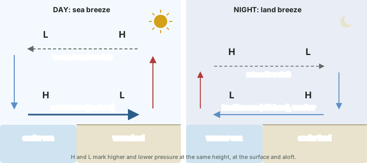
Stull adds the numbers. "A sea breeze is a shallow cool wind that blows onshore (from sea to land) during daytime". It forms in "large-scale high-pressure regions of weak or calm geostrophic wind under mostly clear skies"; a strong synoptic wind would sweep the local contrast away. Similar lake breezes blow off large lakes. "The sea breeze is caused by a 5 °C or greater temperature difference between the sun-heated warm land and the cooler water." At the coast, a fully developed sea breeze blows at 1 to 10 m/s near the surface, typically 6 m/s.
How a temperature contrast becomes a wind
Why does the wind start? Warming the land column makes it expand, so pressure falls more slowly with height over the land than over the sea. A little way up, pressure is therefore higher over the land than over the sea at the same height, and air aloft drifts out to sea. With air leaving the land column, the surface pressure over land falls, and the surface air flows in from the sea to fill it. This is Stull's explanation, built on the hypsometric idea that warm air columns are thicker.
The leading edge of the cool sea air is the sea-breeze front. It "behaves similarly to a weak advancing cold front or a thunderstorm gust front", and it can be marked by a line of cumulus clouds, or by thunderstorms if the air inland is unstable. Stull gives its reach: "The sea-breeze front can advance L = 10 to 200 km inland by the end of the day, although typical advances are L = 20 to 60 km". Over the water, the whole circulation can extend 20 to 250 km out to sea, and Stull notes that mariners used these breezes. At night "a weaker, reverse circulation called the land-breeze forms in response to the nighttime cooling of the land surface relative to the sea".
Mountain and valley winds
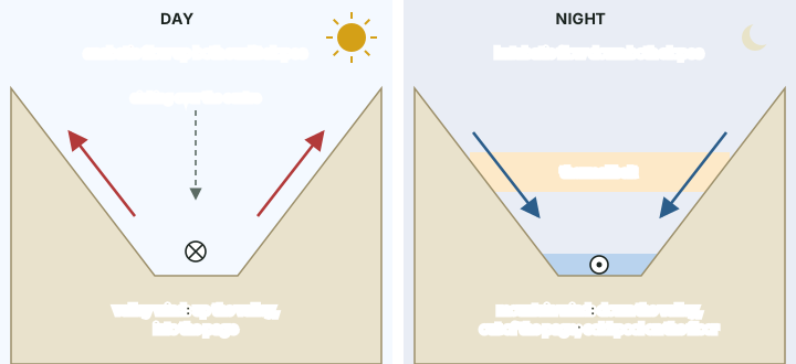
NCERT describes the daily cycle in a valley. By day the slopes heat up, the air over them rises, and air from the valley moves up to replace it: "This wind is known as the valley breeze." "During the night the slopes get cooled and the dense air descends into the valley as the mountain wind." NCERT then adds a third name: "The cool air, of the high plateaus and ice fields draining into the valley is called katabatic wind."
Stull separates two directions of flow, and keeping them apart clears up most confusion:
- Cross-valley (slope) winds run up or down the side slopes. By day the anabatic wind climbs the sunlit slopes, typically at 3 to 5 m/s and hundreds of metres deep; clouds can form over the ridge tops where it rises. At night the katabatic wind drains down the cooled slopes, typically 10 to 100 m deep and 3 to 8 m/s. "Katabatic flows are shallower and less turbulent than anabatic flows."
- Along-valley winds run along the valley floor. By day the valley wind blows up the valley towards the mountains; at night the mountain wind blows down the valley and out onto the plains. Each has a weaker return flow above it (the anti-valley and anti-mountain winds).
Don't confuse: Mountain wind or katabatic wind?
NCERT's night-time "mountain wind" and its "katabatic wind" are often treated as one thing. Stull keeps them apart by direction: "Katabatic winds are cross-valley flows that merge into the along-valley mountain winds draining down the valley." In short, katabatic means down the side slopes, mountain wind means down the valley. Both are cold, dense air flowing downhill, which is all the US National Weather Service glossary asks of a katabatic wind: "A wind that is created by air flowing downhill" (US National Weather Service glossary, "Katabatic wind").
Three consequences are worth knowing:
- Thermal belt. On clear nights the coldest air collects on the valley floor, while a band of the middle slopes stays milder. Stull calls it "a good place for vineyards and orchards because of fewer frost days". This is the cold-air drainage and valley inversion described in the part on temperature.
- Trapped pollution. By day, sinking air over the valley centre "helps trap air pollutants" in the valley.
- Katabatic winds can be fierce. Over Antarctica, where the slopes run for hundreds of kilometres, katabatic winds blow at 3 to 20 m/s, reach 50 m/s in extreme cases and last for days. The Coriolis effect turns them 30 to 50 degrees to the left of straight downhill (Stull). Katabatic flow can also form by day over snow- or ice-covered slopes.
Gap winds
In winter, cold air often lies dammed against one side of a mountain range. When a low approaches the other side, the pressure difference across the range pushes the cold air through any gap it can find: a river valley, a fjord, a strait or a pass. Stull gives the scale: gap winds of 5 to 25 m/s have been observed, with gusts to 40 m/s; at the top of the cold-air layer the temperature jumps by 5 to 10 °C (15 °C in extremes), so a sharp inversion caps the flow; and the flowing layer is 500 m to over 2 km deep. Stull separates short gaps from long ones (about 100 km long and 2 to 20 km wide), where the Coriolis effect matters too. "In any locale, the citizens often name the gap wind after their town or valley."
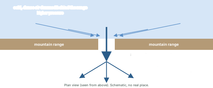
Two of the best-known European winds work this way. The mistral is a strong, turbulent and generally dry wind of south-east France, felt as cold even on hot summer days. It blows from the north down the Rhône valley, from the north-west around Marseille and from the west along the Var coast and Corsica. It blows when north-westerly flow lies between a high near the Atlantic and a low over the Gulf of Genoa, often behind a cold front; the Alps block the air and the Rhône corridor, narrowest between Valence and Donzère, funnels it. Its mean speed is about 50 km/h, with gusts of 80 to over 100 km/h, and an episode can last several days, sometimes more than a week. It is often stronger in winter and spring (Météo-France, "Le mistral" (page dated 5 Aug 2026)).
The tramontane is its western neighbour: a turbulent, violent north-westerly that blows from Roussillon through the Aude valley to western Hérault. It speeds up through the bottleneck between the Massif Central and the Pyrenees near Carcassonne, can gust above 100 km/h on the lower Aude plains and at Cap Béar, and is usually cool or cold, though when it blows without the mistral the air it brings is often mild (Météo-France, "La tramontane" (page dated 5 Aug 2026)). It can rise in any season, most strongly in winter and spring (Météo-France, "Les vents régionaux" (page dated 29 Sep 2026)). A climate study of both winds notes: "They are caused by similar synoptic situations, and consequently, they often coincide" (Obermann-Hellhund et al. (2018), Climate Dynamics 50: 693-703).
Fall winds and the bora
Strong winds can come down the lee side of a range in several ways; Stull says such "fast winds, generically called fall winds" can descend the lee slope, and the US National Weather Service glossary defines a fall wind simply as "A strong, cold, downslope wind" (US National Weather Service glossary, "Fall wind"). The classic fall wind is the bora.
A bora needs a pool of very cold air on the windward side that is deeper than the ridge is high, and strong upstream winds that push it over the crest. Squeezed through the narrow space over the crest, the flow speeds up (the Venturi effect) and pours down the lee slope as a very fast cold wind, which Stull says can reach hurricane force. It warms by compression on the way down but stays cold, because it started so cold. The NWS glossary puts it exactly that way: "A regional downslope wind whose source is so cold that it is experienced as a cold wind, despite compression warming as it descends the lee slope of a mountain range" (US National Weather Service glossary, "Bora").
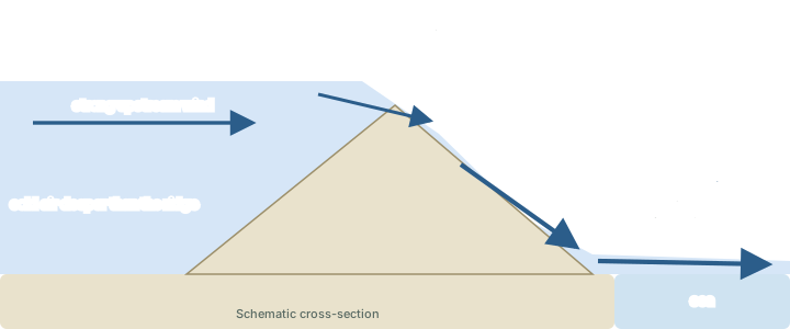
The name comes from one coast. "Boras were originally named for the cold fall wind along the Dalmatian coast of Croatia and Bosnia in winter, when cold air from Russia crosses the mountains and descends southwest toward the Adriatic Sea. The name Bora is used generally now for any cold fall wind having similar dynamics." Like the gap winds, a bora can last for several days.
Don't confuse: Katabatic or bora?
Some textbooks list the bora with the katabatic winds, since both are cold air going downhill. Stull separates them: "The difference between katabatic and Bora winds is significant." A katabatic wind is driven by the cooling of the slope itself and blows when the large-scale wind is weak. A bora is driven by the inertia of strong upstream winds. If an answer needs one line: katabatic = gravity drainage on a calm night; bora = a cold gale forced over a range.
Foehn and chinook
NCERT notes the warm side of the story without naming it: on the leeward side of a range the descending air "gets warmed up by adiabatic process. This dry air may melt the snow in a short time." That wind is the foehn. The NWS glossary defines it as "A warm, dry wind on the lee side of a mountain range, the warmth and dryness of the air being due to adiabatic compression as the air descends the mountain slopes" (US National Weather Service glossary, "Foehn"). Stull adds that its onset can bring a very rapid rise in surface temperature, and that it is known as a "snow eater".
"Foehn winds were originally named for the southerly winds from Italy that blow over the Alps and descend in Austria, Germany, and Switzerland." The same kind of wind has other names elsewhere: the chinook east of the Rocky Mountains, the Santa Ana in southern California, the zonda in Argentina, the austru in Romania and the aspre in France (Stull).
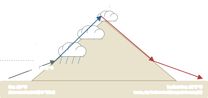
Stull gives three ways a foehn can arise:
- Dammed cold air. Cold air is trapped on the windward side, so the air that crosses the range comes from higher up. It descends the lee slope and warms by compression, arriving warmer than the air it replaces.
- Latent heating. Moist air rises up the windward slope, cools, condenses and rains out, gaining the latent heat of condensation. Having lost its moisture, it descends the lee slope dry and arrives warmer and drier than it began. The bank of cloud that hangs over the crest is the foehn wall.
- Wake turbulence. Turbulence in the lee of the range mixes warm air downwards from an elevated temperature inversion.
The second mechanism is the textbook one, and its arithmetic uses the lapse rates explained in the part on water in the atmosphere. Unsaturated air cools by 9.8 °C for every kilometre it rises (the dry adiabatic lapse rate) and warms by the same rate as it sinks. Saturated air cools more slowly, by about 6 °C per kilometre on average, because condensation releases latent heat.
Worked example: Warming across a 3 km range
Air at sea level is at 20 °C. It is forced over a range 3 km high; its cloud base is at 1 km, and all the condensed water rains out on the windward side. Using 9.8 °C/km for unsaturated air and 6 °C/km for saturated air, find its temperature back at sea level on the lee side.
- Rising dry from 0 to 1 km: 20 - 9.8 × 1 = 10.2 °C at the cloud base.
- Rising saturated from 1 to 3 km: 10.2 - 6 × 2 = -1.8 °C at the summit.
- Sinking dry from 3 km to 0 m: -1.8 + 9.8 × 3 = 27.6 °C.
- Check: the net gain is (9.8 - 6) × 2 = 7.6 °C, the latent heat released over the 2 km of saturated ascent.
Answer: 27.6 °C on the lee side, 7.6 °C warmer than at the start, and drier (computed).
Not every foehn is that dramatic. In Stull's own worked example the air ends up "much drier (RH ≈ 25%) on the lee side, but nearly the same temperature as initially. This is typical of a foehn wind."
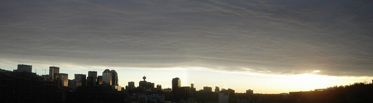
In the United States, "the term chinook is used for Foehn winds in the Rocky and Sierra mountains" (US National Weather Service glossary, "Foehn"). The NWS adds that the chinook "is a fairly common wintertime phenomena in the mountainous west and in parts of Alaska" (US National Weather Service glossary, "Chinook"). Its herald is the chinook arch, "a bank of altostratus clouds east of the Rocky Mountains, heralding the approach of a chinook", which forms in the rising part of standing waves on the lee side. The Santa Ana of southern California is, in NWS words, "a weather condition in which strong, hot, dust-bearing winds descend to the Pacific Coast" (US National Weather Service glossary, "Santa Ana").
Density currents and the southerly buster
When cold, dense air meets warmer, lighter air along a boundary, the cold air spreads out underneath as a density current. Its leading edge lifts the warmer air ahead of it, which can form a line of cloud. The sea-breeze front described above is one; a thunderstorm gust front is another; the cold front (see air masses and fronts) behaves in a similar way.
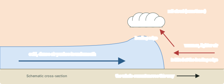
A spectacular example is the southerly buster of south-eastern Australia, which the Bureau of Meteorology describes as "an abrupt southerly change that can charge up the New South Wales coast, mostly between October and February". A cold front crosses south-eastern Australia; the cool air behind it is trapped against the mountains of the Great Dividing Range and moves north along the coast as a shallow density current, replacing hot northerly or westerly winds. Its gusts often exceed 60 km/h, the temperature can fall by 10 to 15 °C within an hour, and the leading edge is sometimes marked by a roll cloud. Sydney gets about five a year; the stronger ones arrive in the late afternoon or early evening after several days of hot weather. The Bureau adds that "this fast-moving southerly change is not unique to New South Wales": Tasmania, New Zealand and Argentina see similar changes (Bureau of Meteorology blog, "The big bust—southerly busters explained!" (30 Oct 2011)).
Named winds of the world
Most named winds are local versions of the five families above. The tables give where each blows, what it feels like and what drives it, with the source for each. Learn the mechanism first; the name then tells you the rest.
Named winds: Europe and the Mediterranean
| Wind | Where | Character | Cause or season |
|---|---|---|---|
| Mistral | Rhône valley and the coast of south-east France, out to Corsica | strong, turbulent, generally dry; felt as cold; gusts 80 to over 100 km/h | gap wind between an Atlantic high and a Gulf of Genoa low; often stronger in winter and spring |
| Tramontane | Roussillon, the Aude valley, western Hérault | violent, turbulent north-westerly, usually cold (mild when it blows alone); gusts can exceed 100 km/h | gap wind between the Massif Central and the Pyrenees; any season, strongest in winter and spring |
| Bora | Dalmatian coast of the Adriatic | cold fall wind; can reach hurricane force | winter; cold air from Russia crosses the mountains and descends south-west to the sea |
| Sirocco | from North Africa across the Mediterranean | warm southerly: hot, dry and dusty near Africa, moist with low cloud by the time it reaches Europe | a blanket term that covers the ghibli (Libya), chili (Tunisia) and khamsin (Egypt) |
| Khamsin | Egypt and the Red Sea | hot, dry, dusty southerly | ahead of depressions moving east, while pressure is high east of the Nile; most frequent April to June |
| Leveche | south-east coast of Spain | hot, dry southerly carrying dust and sand; a brownish strip of cloud on the southern horizon | ahead of a depression |
| Levant | Strait of Gibraltar | humid easterly | most frequent June to October, possible in any month |
| Etesians (meltemi) | eastern Mediterranean, above all the Aegean | northerly winds (north-east to north-west) under clear skies, about 5 m/s over the Aegean | high pressure over the western Mediterranean and Balkans against the Persian heat low; May to September (Met Office) or June to September with a July-August peak (Di Capua et al.) |
Sources: Météo-France, "Le mistral" (page dated 5 Aug 2026); Météo-France, "La tramontane" (page dated 5 Aug 2026); Météo-France, "Les vents régionaux" (page dated 29 Sep 2026); R. Stull, Practical Meteorology (Univ. of British Columbia, via LibreTexts), section 17.10 (bora); Met Office, "Winds of the world" (sirocco, khamsin, leveche, levant, etesians); Met Office climate report "Egypt" (khamsin); Di Capua et al. (2024), Climate Dynamics 62 (etesians).
The Met Office notes that the etesians are known as the meltemi in Turkey. Its "levant" is the wind of the Strait of Gibraltar; do not mix it up with winds of the same name elsewhere.
Named winds: the rest of the world
| Wind | Where | Character | Cause or season |
|---|---|---|---|
| Foehn | lee of the Alps (Austria, Germany, Switzerland); now any range | warm, dry; the "snow eater" | air warmed by compression as it descends the lee slope |
| Chinook | east of the Rocky Mountains | the US name for a foehn; common in winter | foehn mechanism; heralded by the chinook arch |
| Santa Ana | southern California | strong, hot, dust-bearing winds descending to the coast | listed by Stull among the foehn winds |
| Zonda, austru, aspre | Argentina, Romania, France | foehn winds | foehn mechanism |
| Harmattan | West Africa | dry and relatively cool north-easterly or easterly; dust haze | the northern-hemisphere dry season |
| Berg wind | interior of South Africa and Namibia, blowing to the south and west coasts | dry offshore wind bringing "unseasonably warm temperatures" | winter; descends from the interior plateau |
| Southerly buster | coast of New South Wales, Australia | abrupt cool southerly; gusts often over 60 km/h; a 10 to 15 °C fall | density current trapped against the Great Dividing Range; mostly October to February |
| Williwaw | mountainous coasts, as in the Aleutian Islands | sudden, violent, cold gust down to the sea | cold air spilling off the mountains |
Sources: R. Stull, Practical Meteorology (Univ. of British Columbia, via LibreTexts), section 17.10 (foehn names); US National Weather Service glossary, "Foehn"; US National Weather Service glossary, "Chinook"; US National Weather Service glossary, "Santa Ana"; Met Office, "Winds of the world" (harmattan, berg wind); Fazel-Rastgar and Mthembu (2026), Air Quality, Atmosphere and Health (berg wind); Bureau of Meteorology blog, "The big bust—southerly busters explained!" (30 Oct 2011); US National Park Service newsletter The Williwaw (2020) (williwaw).
Don't confuse: Hot or not?
The harmattan is a dry, dusty wind, but not a hot one: the Met Office calls it "dry and relatively cool", and nicknames it "the doctor". A medical review dates the season from "the end of November and mid March" ("The Cold Dusty Harmattan" (medical commentary, PMC5004994)). The berg wind is the opposite case: a winter wind that is warm because it comes down from the plateau, described in a 2026 study as "dry continental offshore winds descending from the interior plateau toward the coast" (Fazel-Rastgar and Mthembu (2026), Air Quality, Atmosphere and Health).
A blizzard is defined by its effects rather than its origin. Under the US National Weather Service definition, a blizzard means winds of 35 mph (about 56 km/h, computed) or more with considerable falling or blowing snow, visibility frequently below a quarter of a mile (about 400 m, computed), lasting 3 hours or longer (US National Weather Service glossary, "Blizzard").
India's own local winds belong to the Indian climate page. NCERT explains the loo as advection: "In tropical regions particularly in northern India during summer season local winds called 'loo' is the outcome of advection process" (NCERT, Fundamentals of Physical Geography, Class XI, ch 8 "Solar Radiation, Heat Balance and Temperature" (Reprint 2026-27)). The loo, the Nor'westers and the western disturbances are taught on page 08 (Monsoon Mechanism, Jet Streams and Tropical Cyclones).
Summary
The record 24-hour temperature change
The US National Weather Service records that "In Loma, Montana, the temperature soared from 54 degrees below zero to 49 degrees above zero on January 14-15, 1972." It adds: "The 103-degree change is the greatest ever recorded in the world for a 24 hour period." Those are Fahrenheit degrees: -54 °F is about -47.8 °C, 49 °F is about 9.4 °C, and the change of 103 °F is about 57.2 °C (computed, × 5/9) (US NWS Aberdeen, "This Day in Weather History: January 14th").
- 5 °C land-sea contrast that drives a sea breeze (Stull)
- 20-60 km typical inland reach of the sea-breeze front by evening
- 3-8 m/s typical katabatic wind; up to 50 m/s in Antarctic extremes
- 5-25 m/s observed gap winds, gusts to 40 m/s
- +7.6 °C foehn warming in the worked example (computed)
- 10-15 °C temperature fall in a southerly buster, often within an hour
In one minute
- Thermal winds reverse daily: sea breeze by day, land breeze by night; anabatic and valley winds by day, katabatic and mountain winds by night.
- Katabatic = down the side slopes; mountain wind = down the valley.
- Gap winds are pushed through passes by a pressure difference: the mistral and tramontane.
- A bora is cold air forced over a range; it stays cold even after warming on the way down.
- A foehn is warm and dry because the air lost its moisture on the windward side and sank at the dry rate: chinook, Santa Ana, zonda.
- The sea-breeze front, the gust front and the southerly buster are density currents.
- The harmattan is dry and relatively cool, not hot.
Sources
Each table and data figure names its source beneath it. The main documents are collected here, with a date where the source carries one. Figures not listed under image credits were drawn for this page from the sources stated in their source lines.
Main sources
| Topic | Source |
|---|---|
| Textbook | NCERT, Fundamentals of Physical Geography, Class XI, ch 9 "Atmospheric Circulation and Weather Systems" and ch 8 "Solar Radiation, Heat Balance and Temperature" (Reprint 2026-27) |
| Mechanisms of local winds | R. Stull, Practical Meteorology (Univ. of British Columbia, via LibreTexts), sections 17.3, 17.5 and 17.10 |
| Definitions of named winds | US National Weather Service glossary: Katabatic wind, Fall wind, Bora, Foehn, Chinook, Santa Ana, Blizzard |
| Mistral and tramontane | Météo-France, "Le mistral" and "La tramontane" (pages dated 5 Aug 2026), "Les vents régionaux" (page dated 29 Sep 2026); Obermann-Hellhund et al. (2018), Climate Dynamics 50: 693-703 |
| Southerly buster | Bureau of Meteorology blog, "The big bust—southerly busters explained!" (30 Oct 2011) |
| Sirocco, khamsin, leveche, levant, etesians, harmattan, berg wind | Met Office, "Winds of the world"; Met Office climate report "Egypt" (khamsin) |
| Etesians | Di Capua et al. (2024), Climate Dynamics 62 |
| Berg wind | Fazel-Rastgar and Mthembu (2026), Air Quality, Atmosphere and Health |
| Harmattan season | "The Cold Dusty Harmattan" (medical commentary, PMC5004994) |
| Williwaw | US National Park Service newsletter The Williwaw (2020) |
| Record 24-hour temperature change (Loma, Montana) | US NWS Aberdeen, "This Day in Weather History: January 14th" |
Image credits
| Image | Credit and licence |
|---|---|
| Chinook arch over Calgary, Alberta, Canada (March 2007) | Qyd. CC BY 2.5, via Wikimedia Commons. File page |
| Foehn wall at Zurich airport, Switzerland (28 February 2010) | Aero Icarus from Zürich, Switzerland. CC BY-SA 2.0, via Wikimedia Commons. File page |
| All other figures | Drawn for this page from the sources given in their source lines. |



